[a post by Anne Jefferson]
If I had a time machine and could go back to any point in geologic history, as supposed in this month’s Accretionary Wedge call, the event that I’d most like to see is the repeated flooding of the Pacific Northwest at the end of the last Ice Age. These “Missoula floods” are among the largest floods in Earth history and they irrevocably changed the topography of Washington and Oregon. My time machine would be an aircraft capable of flying with the floodwaters as they raced from Montana to the Pacific Ocean, and my time machine would also have LIDAR capabilities for collecting pre-, syn-, and post-flood digital measurements of topography and water surfaces and allowing an unparalleled determination of flood magnitudes and erosive volumes.
Our story begins 19,000 years ago, shortly after the Last Glacial Maximum, deep in the heart of the Bitterroot Mountains in western Montana (Figure 1), as melt water from the waning glaciers began to pour into Clark Fork River valley and its tributaries. Water in the Clark Fork ponded up behind an enormous ice dam from a lobe of the Cordilleran Ice Sheet, and reached a maximum depth of 600 meters as Glacial Lake Missoula. The lake contained more than 2000 cubic kilometers of water, more than the modern volume of Lake Erie and Lake Ontario combined. Pedestrians in the modern day town of Missoula might notice a strange horizontal striping to the hillsides surrounding town (Figure 2)…these are the traces of the shorelines of the ancient lake.
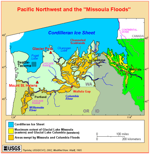
Figure 1. USGS map of the Pacific Northwest between ~12 and 19 thousand years ago.
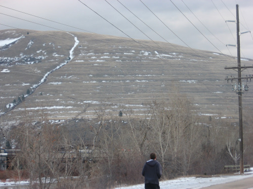
Figure 2. Traces of Glacial Lake Missoula in Missoula, Montana, February 2009. Photo by the author.
A little after 19,000 years ago, water in Glacial Lake Missoula ruptured the ice dam, and the collected water went rushing downstream at speeds reaching 100 km/hr. Peak discharge in the Spokane Valley has been estimated at 17 +/- 3 million cubic meters per second, and drainage of the lake took several days.
Today, the Clark Fork River drains into the upper Columbia River and then into the Pacific Ocean. At the time of the Missoula Floods, the upper Columbia was buried under glaciers and that route was blocked to the floodwaters from Glacial Lake Missoula, so instead they were forced to take an overland route, carving new channels into the fertile Palouse loess deposits and the underlying 17 million year-old Columbia River basalts of eastern Washington. These channels are spectacular (Figures 3 and 4): up to 182 m deep and 32 km wide, with dry waterfalls, scoured potholes, and streamlined islands. Granite boulders the size of small cars were carried by the flood from the Idaho batholith and deposited in central Washington. Even for geologists, it can be hard to appreciate the full extent of these floods from the ground, but satellite photos (Figure 5) show the huge aerial extent of the erosion, covering a region we now call the Channeled Scablands.
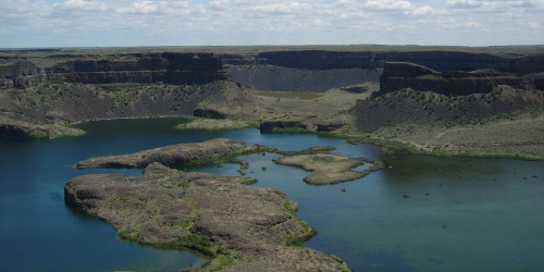
Figure 3. Dry Falls and Grand Coulee near Coulee City, Washington, June 2004. The falls are 122 m high and 5.6 km wide. Photo by the author.
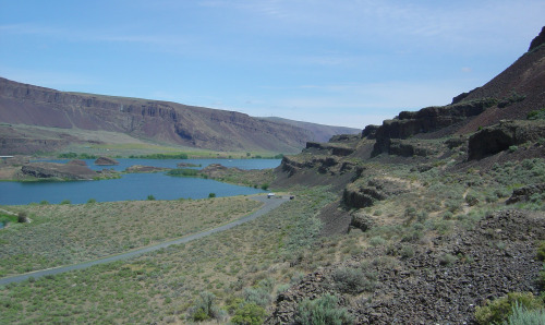
Figure 4. Grand Coulee downstream of Dry Falls as viewed from Lenore Caves, June 2004. Photo by the author.

Figure 5. Landsat view of the Channeled Scablands region. This image was taken on August 31, 1972 and shows about 34,250 square kilometers of eastern Washington. The dark green features are the channels, the light green is the wheat-farmed Palouse region and the modern Columbia River is at the top right. Image retrieved from a National Park Service website.
Several times along their way across Washington, the floodwaters found basins in which to spread out and slow down. The fertile, wine-growing soils of the Yakima and Walla Walla valleys are slackwater flood deposits of loess from the Palouse valley. In a few special places, we can see the thick layers of silt, separated by thin horizons of soil (Figure 6). The number of layers preserved in these places help constrain the number of floods, and ash layers in the soils help constrain their timing. The best estimate is that there were more than 40 late Pleistocene megafloods that crossed eastern Washington, though not all of them may have come from from Glacial Lake Missoula itself. The floods began after 19 thousand years ago, many occur after 15 thousand years ago, and some post-date a Mount Saint Helens eruption 13 thousand years ago. More than 25 floods had peak discharges exceeding 1 million cubic meters per second.
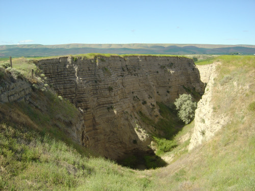
Figure 6. Missoula flood deposits in the Walla Walley valley, Washington, June 2004. Photo by the author.
Where the Columbia River turns east and runs along the modern-day border of Oregon and Washington, the Missoula Floods were once again confined to a single channel, at a place called Wallula Gap. As immense as the Columbia River Gorge is (Figure 7), this channel was a major constriction on the flood, only able to transmit 20% of the peak discharge. The waters therefore backed up behind the gap, flooding the Pasco Basin and creating a temporary lake – Lake Lewis – around the tri-cities region of Washington. Floodwaters in the gorge were more than 215 m deep, as evidenced by the flood deposits found on surrounding ridgelines. The town of Lyle, Washington, in the Columbia River is built on a giant eddy bar left by the floods (Figure 7).
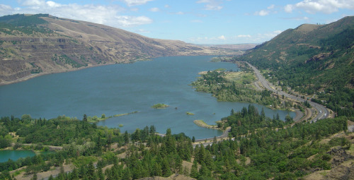
Figure 6. Columbia River Gorge, looking upstream from Rowena Crest, Oregon, June 2004. Photo by the author.
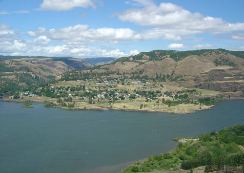
Figure 7. Lyle, Washington, as viewed from Rowena Crest, Orego. Photo by the author in June 2004.
When the floods reached Portland, Oregon, the waters filled the Willamette Valley, producing a lake 100 m deep, approximately 50 km wide, and 175 km long. Today the lake bottom is seen in the flat topography and fertile soils of the valley. Icebergs, probably remnants of the glacier that dammed Lake Missoula, were carried this far, because the valley is pocked by glacial erratics (Figure 8), rocks that had fallen onto or into the ice, were rafted downstream, and left behind when the icebergs melted. These rocks are not rounded, so it is clear that are not material moved by the flood itself.
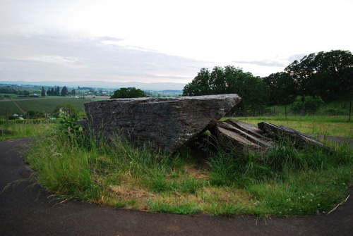
Figure 8. Glacial erratic on the edge of the Willamette Valley in Erratic Rock State Park, Oregon. Photo taken May 2008 by aboutmovies and used under Creative Commons license.
Slowly the water would drain from the Willamette Valley and upstream lakes and empty completely into the Pacific Ocean through the Columbia River. Vegetation would encroach on the new sediments, and soil would begin to develop. In the meantime, another Glacial Lake Missoula would be forming behind a new ice dam on the Clark Fork River, getting ready to repeat the process again. Presumably floods of varying magnitudes continued until the glaciers had retreated north of the river. The last floods probably occurred less than 13 thousand years ago.
Floods over, measurements completed, my time machine and I would return to the present, ready to fill in the details of the floods that shaped the topography, soils, and agriculture of the Pacific Northwest. Even without a time machine, there’s so much more I could tell you about the Missoula Floods, but I’ve already gone on long enough. Instead I’ll refer you to the numerous scientific papers on the subject beginning with those of J. Harlan Bretz in the 1920s. When Bretz proposed a megaflood as the source of the Channeled Scablands, it flew in the face of the ruling uniformitarian paradigm and his work was not accepted for several decades. The casual audience may want to check out the Ice Age Floods Institute website, an on-line USGS publication on the The Channeled Scablands of Eastern Washington, the book Cataclysms on the Columbia, and, if you can find it airing sometime, the excellent Oregon Public Broadcasting documentary Ice Age Floods. If you live in or are traveling to the Pacific Northwest, also keep an eye out for sites along the newly-approved Ice Age Floods National Geologic Trail.
Categories: by Anne, geology, outcrops, past worlds, Pleistocene


Comments (14)