The latest from Lusi
![]() Two years after it first erupted,
Two years after it first erupted,
The world’s fastest-growing mud volcano is collapsing by up to three metres overnight, suggests new research.
As the second anniversary (May 29) of the eruption on the Indonesian island of Java approaches, scientists have found that the volcano – named Lusi – could subside to depths of more than 140 metres with consequences for the surrounding environment.
The sudden overnight three metre collapses could be the beginning of a caldera – a large
basin-shaped volcanic depression – according to the research team, from Durham University UK, and the Institute of Technology Bandung, in Indonesia.Their findings, based on Global Positioning System (GPS) and satellite measurements, are due to be published in the journal Environmental Geology.
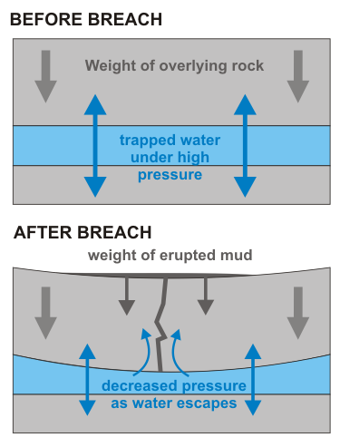
The fact that subsidence is occuring is actually no surprise; it’s a natural consequence of the eruption itself. Lusi was the result of the breaching of a subsurface aquifer – a porous, water-bearing rock horizon, which was being squeezed by the weight of all the overlying rocks. Because the cap rocks were impermeable mudstones, the water couldn’t move anywhere in response to this squeezing, meaning that the water within the aquifer was being held under extremely high pressure. As soon as the breach occurred, all that pressure had an outlet, causing high pressure water to burst upwards, mixing with the overlying mudstones on the way to create the lovely ooze that is currently engulfing Sidoarjo province. For those who remember Super Soakers, they work along a similar principle – you increase the water pressure by pumping air into a sealed water reservoir, resulting in a much stronger water jet when you finally pull the trigger and create a ‘breach’.

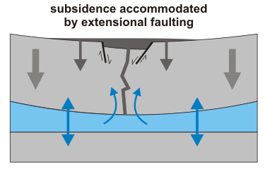
Obviously this is going to lead to a decrease in water pressure within the aquifer; since this pressure was resisting the weight of the overlying rock – now augmented by the weight of the mud that has erupted onto the surface – a decrease will lead to compression of the aquifer, and subsidence, in the area where the eruption is occuring. The Environmental Geology paper by Abidin et al. observes exactly this. The GPS data presented was collected between June 2006 and September 2007, and indicates fast subsidence of 2-4 centimetres a day in the first four or five months after the eruption, and slower (and apparently slowing) subsidence of 0.1-0.3 cm a day thereafter. Even after it slowed down, that’s getting on for a metre of displacement every year, which is very fast by geological standards. The paper also refers to more recent measurements where large vertical displacements – 10s of cm or even metres – appear to have occurred literally overnight, which might indicate that some of the subsidence is now being taken up by extensional faulting around the vent.

The formation of such a caldera may restrict the lateral extent of the mud flow, by creating a natural hole for it to fill (although human intervention though the building of dams is also a control here).
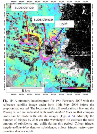
Radar interferometry, which compares altimetry data collected after the eruption to altimetry collected before to highlight changes in topography, has also been used to examine elevation changes over a wider area, and confirms that subsidence has occurred up to 10 km from the central vent. Interestingly, it also shows that a sizable area to the northeast has been uplifted since the eruption:

The boundary between the uplifted region and the subsiding vent follows the trend of a fault which runs through the area, indicating that it has been active since Lusi first erupted. This is very interesting, because it is this fault – the Watukosek Fault – that has been cited in the argument that Lusi was a natural response to an earthquake, rather than shoddy drilling practices. Does this new data support that interpretation, and let PT Lapindo Brantas (or whatever they’re called now) off the hook? No, actually – the deformation associated with motion on this fault only begins after July 2006, two or three months after the eruption first started, so it in fact fairly conclusively proves that it was not involved in the initial breakthrough. Somehow, though, I doubt this will be the final word on this particular subject.
Abidin, H.Z., Davies, R.J., Kusuma, M.A., Andreas, H., Deguchi, T. (2008). Subsidence and uplift of Sidoarjo (East Java) due to the eruption of the Lusi mud volcano (2006-present). Environmental Geology DOI: 10.1007/s00254-008-1363-4


Comments (4)