When geologists talk about how old a rock or a fossil is, or when a particular tectonic event happened, they don’t usually just give an age in millions or billions of years – they also state its location within a hierarchy of Eons (Phanerozoic, Proterozoic), Eras (Mesozoic, Cenozoic), and Series (Jurassic, Neogene) that make up the geological timescale.

The fact that the time axis is rescaled three times in the plot above indicates that these subdivisions are not regularly spaced chunks of time; the more recent geological periods are generally much shorter than the earlier ones. The reason for this is partly historical; the general structure of the timescale was developed before the advent of radiometric dating techniques allowed absolute age determinations. However, it is also a consequence of what these subdivisions actually represent. The overarching goal of Geology as a science is to reconstruct the history of the Earth, and each of the geological periods can be considered chapters in this story; each one has its own distinctive characters – the form and diversity of life – and setting – the climate and the configuration of the continents. For example, the Mesozoic Era represents a time where dinosaurs, giant marine reptiles and ammonites were dominant on a warm, dry planet with no ice caps and most of the continents amalgamated into Pangaea.
With this in mind, it becomes no surprise that the further back we go, the coarser our framework becomes. Older rocks are both rarer and less easy to read, because they tend to be more deformed and chemically altered, so we lose a lot of the details which might allow further subdivision. The lack of any fossilised large animals prior to the Cambrian/Ediacaran is a major contributor to this loss of resolution – if you examine the International Commission on Stratigraphy chart on which the timescale above is based, you’ll see that many of the boundaries between different periods are defined (or proposed to be defined) by the first or last appearance of a particular type of fossil.
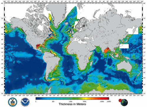
So, the geological timescale represents a common narrative framework for Earth history. However, do not let this fool you into believing that every rock of a particular age is the same. The reason why should be obvious: the Earth is a very dynamic place, and at any point in time there are a wide variety of different depositional processes simultaneously operating in different places. As the map below (from here, courtesy of Brian – click on the image for a larger version) illustrates, presently you’re getting much larger amounts of sediment accumulating in the Ganges and Mississippi deltas, say, than off the coast of Australia.
Continental deposition is not shown on this map, but without a big hole to dump sediment in there is little being deposited in many places beyond the occasional layers of silt from rivers in flood. The only exception is in the mountain belts, where large thicknesses of rocks are being eroded away, the records they hold being erased from the face of the planet.
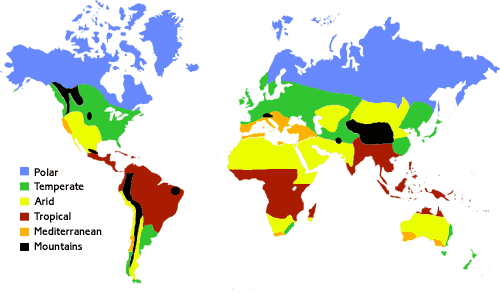
The depositional environment will also depend on climate; you won’t get evaporites and limestones forming at the poles and glacial till at the equator; neither will you get dune deposits forming in rainforests and soil horizons in deserts.
To use a historical analogy, if you’re told someone lived in Victorian Britain, that tells you a lot about the world they inhabited: the technology, the political situation, the average life expectancy. But you couldn’t say just from that information what profession they had, who they voted for, or the precise causes of their death; that is unique to that person. Likewise, calling a deposit ‘Ordovician’ tells you some general things about the world it was deposited in, but it doesn’t specify its type or its thickness, and there are many places where there will be no rocks of Ordovician age at all – they either never existed in the first place, or they have been eroded away by a later mountain-building episode.
So, there is no single ‘geological column’ for the whole Earth; each area has its own unique stratigraphy, or sequence of rock types. Which is where we geologists come in: because, to reconstruct the larger story encapsulated in the geological timescale, we have to correlate all these stratigraphic columns, working out which units were deposited at the same time as each other. We can use radiometric dating to give us absolute ages for the different sequences, but often we look for global events or signatures which many or all of them have in common.*
- The pattern of magnetic field reversals
- The occurrence of index fossils which have both a widespread distribution and a rapid rate of evolutionary change.
- Geochemical signals, for example the iridium anomaly which marks the KT extinction, or the Plio-Pleistocene oxygen isotope variations due to the waxing and waning of the ice-caps.
All of these methods have their advantages and drawbacks, but by employing all of them we can start to tie all of these different sequences into a common timescale, and start asking the interesting questions about what was actually happening in the world at the time they were deposited.
*Which is why, all you biblical literalists out there, we’d love for there to have been a global flood – the sediments laid down by such an event would be the ultimate correlatable horizon, because they would exist in every stratigraphic column in the entire world. Sadly for us (and you), it’s just not there, so we have to do things the hard way.


Comments (9)