The 2011 Grímsvötn eruption was the biggest explosive Icelandic eruption since Katla 1918*, producing twice as much material as Eyjafjallajökull 2010 in around one tenth of the time. During and after the eruption, many scientists measured the effects that it had on the UK. The final version of our paper containing the findings was published last week.
The paper uses results of a citizen science tape-sampling exercise (co-organised by the British Geological Survey and this blog) along with data from public agencies such as the Department for Environment, Food and Rural Affairs (DEFRA), the Scottish Environment Protection Agency (SEPA) and the Met Office, to show where and when the ash fell.
We found that the north of the UK (mainly Scotland) received a light dusting of ash in the 48-72 hours following the beginning of the eruption, which caused little or no health or environmental problems. This post explains how we know this.
The greatest impact of the Grímsvötn eruption on the UK was the disruption to aviation. A second blog post discusses how new flight rules introduced during the Eyjafjallajökull 2010 eruption meant that the eruption caused much less trouble than it could have done.
Where ash fell in the UK
After Eyjafjallajökull, we found that it was hard to say exactly where ash had fallen, or when, because we only had data from a few samples. This time, we decided to get the public involved and put a video online showing people how to collect samples. It explained how to use common household items (e.g. sticky tape and plain paper) to make simple ‘slides’. We used Twitter, Facebook and the British Geological Survey’s press office contacts to spread the word and got 130 samples from across the UK. Some were from individuals, others were from whole school classes. We checked them under the microscope to see if we could find ash.

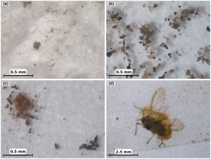
Things that we found in the sticky-tape slides. (a) Volcanic ash grains were tiny, brown-yellow, glassy and often clumped together. (c-d) We also found wind-blown sand, soot, and bits of plants and dead insects. Click image to enlarge. Refer to full paper for more details.
The ash grains were tiny, just 25 millionths of a metre, but you can still recognise them because they look glassy and have a yellow-brown colour, and because they often clump together. The slides were contaminated with other stuff, too, such as wind-blown sand, soot, pollen and even dead flies. These made it hard to be sure if ash was definitely there, so we divided them into three groups: no ash, possible ash, likely ash, and the slides were checked by three different people.

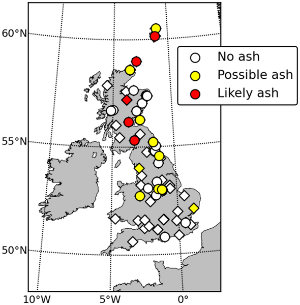
Results from sticky-tape samples. All the samples with “Likely ash” and most with “Possible ash” came from Scotland and were collected on 24 May 2011. Refer to full paper for more details.
We found that all the “likely ash” samples came from Scotland, and most of the “possible ash” samples were also from northern parts of the UK. “No ash” samples were found across the UK. We also checked when the samples had been collected; most ash fell on Tuesday 24th May (the eruption began on the previous Saturday evening). The results agreed with rainwater samples that we analysed from rain gauges (collected by volunteers, too; Thank you), which also contained volcanic ash grains. The amount of ash in each location was very small (remember that Grímsvötn is over 900 km from NW Scotland). In most places, ash was only noticeable if you looked really carefully, but in Thurso, Shetland and Orkney, in the far north of Scotland, it was thick enough to make all the cars look dirty. The sticky-tape samples were a big help in working out where the ash fell.
Effects on health and the environment
DEFRA and SEPA collected data during the eruption that we incorporated in our study. DEFRA has a network of air quality monitoring stations that check for pollution by recording the concentration of tiny particles (less than 10 millionths of a metre across) in the air. These are called PM10. High PM10 concentrations can cause health problems, especially in people with breathing difficulties, and even small amounts of airborne volcanic ash have been associated with increased deaths in New Zealand.
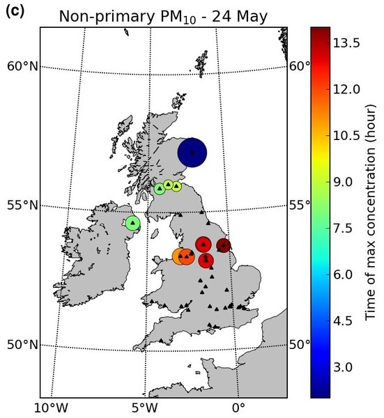
There were big spikes in the amount of PM10 during the eruption, especially in Scotland. The maximum hourly-averaged PM10 was 413 micrograms per cubic metre, recorded in Aberdeen early on 24 May. Not all of these particles were volcanic ash, but by using measurements of other pollutants (e.g. nitrogen oxides) at some of the stations, air pollution experts at King’s College, London, worked out how much is man-made. These results show the ash cloud sweeping southwards across the country on 24 May, reaching the English Midlands in the early afternoon.

Air quality monitoring stations that recorded spikes in airborne particles that were probably volcanic ash. Hotter colours record peaks at later times, so the southward movement of the cloud can be tracked. There are no stations north of Aberdeen; if there were, they would have detected ash, too. Refer to full paper for more details.
Nevertheless, there were no health problems reported. When averaged over 24 hours, the elevated concentrations were still classed as ‘low level’, except for Aberdeen, which reached ‘moderate’ for 24 May. To put these values in context, hourly PM10 concentrations of over 200-300 micrograms per cubic metre can be measured in towns across the UK on Bonfire Night and windblown ash from the last two eruptions in Iceland caused hourly PM10 concentrations in Reykjavík to reach over 700 micrograms per cubic metre during one day this spring. Aircraft flights are restricted at levels of 2000 micrograms per cubic metre, but remember that PM10 measurements are only the finest particles, and only at ground level (see the second post for more on this).
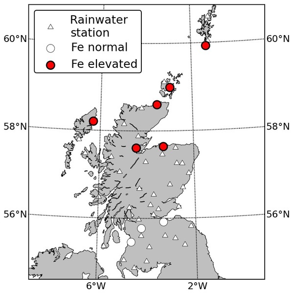
Volcanic eruptions also release acidic gases such as sulphur dioxide (SO2) and fluorine (F2). SO2 dissolves in water to form acid rain, which damages crops and trees. When sheep and other animals eat too much grass contaminated by fluoride, they die of a nasty condition called fluorosis, which can turn their bones as soft as rubber. SEPA tested the acidity (pH) and fluoride content of rainwater samples collected by a network of volunteers, but found no evidence of contamination. They also tested a few samples for iron (Fe) and aluminium (Al) and found the highest concentrations in samples collected (…surprise, surprise…) in northern Scotland on 24 May. These levels were not harmful (in fact, iron from volcanic ash can sometimes act as a fertiliser) but the rainwater chemistry results help us see where most ash fell.

Locations of rainwater chemistry samples (triangles). None detected fluorine or acidic rain. Contamination by iron (Fe) was tested at sites marked with circles, and high concentrations were found in locations marked red. Refer to full paper for more details.
What it all means
Despite being larger and more powerful than the Eyjafjallajökull 2010 eruption, the Grímsvötn 2011 eruption caused minimal disruption or damage to the UK. There is no doubt that Iceland’s volcanoes are capable of huge, destructive and even deadly eruptions, but it is important to remember that not all eruptions actually are. This is especially important given the sensationalist way that they are portrayed in the mainstream media. By improving our monitoring ability during the eruptions with small effects, we increase our ability to cope when a larger eruption eventually comes along.
Further reading
This is the first of two posts about the effects of the Grímsvötn eruption on the UK. Read the second post to find out about the effects on aviation.
Our study was published in the Journal of Applied Volcanology, which is an open access journal. This means that anyone can download and read the full report for free by clicking the link below:
-
Stevenson, J. A., S. C. Loughlin, A. Font, G. W. Fuller, A. MacLeod, I. W. Oliver, B. Jackson, C. J. Horwell, T. Thordarson, and I. Dawson (2013), UK monitoring and deposition of tephra from the May 2011 eruption of Grímsvötn, Iceland, Journal of Applied Volcanology, 2(1), 3, doi:10.1186/2191-5040-2-3.
Last year, we published a similar paper in the Journal of Geophysical Research about the deposition of Eyjafjallajökull ash across Europe :
- Stevenson, J. A., S. C. Loughlin, C. Rae, T. Thordarson, A. Milodowski, J. S. Gilbert, S. Harangi, R. Lukács, B. Højgaard, U. Árting, S. Pyne-O’Donnell, A. MacLeod, B. Whitney, and M.Cassidy, (2012), Distal deposition of tephra from the Eyjafjallajökull 2010 summit eruption, J. Geophys. Res., 117, B008904, doi:201210.1029/2011JB008904.
For other Iceland-volcano related posts, covering topics such as the probability of ash clouds reaching the UK, why volcanoes explode and an account of an expedition to Grímsvötn’s crater, follow the links from my Every Post Ever page.
* Technical point: There are a number of ways to define the size of a volcanic eruption, such as plume height, volume of material erupted, volume of magma involved. These are incorporated into the Volcano Explosivity Index. Here we are talking about the volume of widely-dispersed tephra deposited from a (sub-)Plinian eruption column. The 1963-1967 submarine eruption of Surtsey, and the 1996 subglacial eruption of Gjálp both produced larger volumes of tephra (mainly hyaloclastite), but it was not widely dispersed.


Pingback: Grímsvötn 2011 (Part 2): Effects on aviation of the biggest Icelandic eruption since Katla 1918 | Volcan01010
Pingback: Three years of volcan01010: Highlights of 2013 | Volcan01010
Pingback: An Icelandic eruption 100 times more powerful than Eyjafjallajökull | Volcan01010
Pingback: How big are the grains in a volcanic ash cloud? | Volcan01010
Pingback: Recommended sources of information on Katla volcano | Volcan01010
Pingback: buy ansomone hgh