Note: 02 December 2011.
The current media interest in Katla does not stem from a recent change in activity at the volcano, but from an article published on the BBC website today. The same thing followed a Guardian article earlier in the year. Activity at Katla is still elevated, as it has been for six months already. There is no new evidence today that an eruption is likely very soon. In geological terms, imminent could mean weeks, months, or maybe years. This post was written in early November.
Katla rumbles on.
The unrest began in the summer, when a small flood broke out from beneath the glaciers and washed away the bridge over the Múlakvísl river. Since then, there have been a number of small earthquakes every day. This is more activity than usual, but less than, for example, occurred at Eyjafjallajökull in the weeks before the 2010 eruption. It is not clear where this is heading, but Iceland continues to prepare for an eruption and local towns have been running evacuation drills.
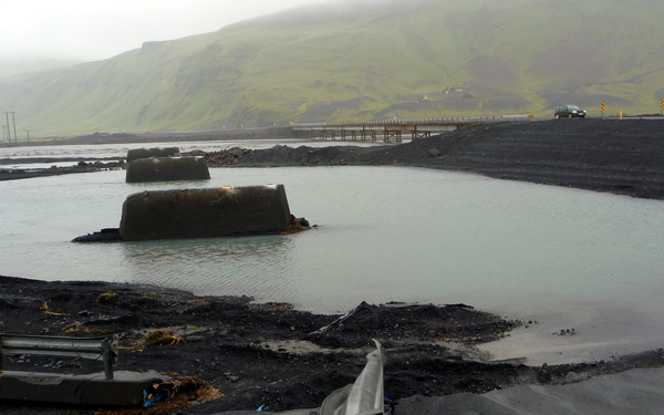
The remains of the bridge at Múlakvísl that was washed away in the flood of July 2011, with the replacement bridge in the background. Note the yellow earth-moving equipment high on the hillside. They aren't parked up there for the view.
While the international media focus on the potential ash cloud and ‘travel misery’, the real destruction in Iceland will be caused by meltwater floods. Katla is covered by glaciers up to 500 m thick. These represent a huge reservoir of water, waiting to be unlocked by the heat of an eruption. A look at floods from the last time round, in 1918, gives an indication of what could be expected.
The jökulhlaup from the 1918 eruption
There is a word in Icelandic for such floods from beneath the ice: jökulhlaup. Translated directly into English, it means glacier leap. This seems appropriate, as the water bursting under, over and through the ice tears off huge chunks and carries them suddenly forward down the valley. When the water subsided after the flood of 1918, the plain was strewn with giant icebergs, up to 60-80 m high.
Eyewitnesses said the speed of the Katla 1918 jökulhlaup was “so great that a fit man could not have avoided it”. Escaping from the eastern side of the glacier, the flood wave reached the ocean in 45 minutes. These reports correspond to a speed of 10 metres per second (36 km per hour). The high-water mark of the jökulhlaup is recorded on the slopes of small hills along the way that were scoured clean by the swirling torrent. Near the glacier, the waters peaked at 25 metres deep.
Haukur Tómasson combined velocity and the depth of the flood with the shape of the channel and came up with an estimate for the peak discharge of 300,000 cubic metres per second. The total volume of water was estimated to be around 8 cubic kilometres. The flooded area was as much as 700 square kilometres. There was sufficient sediment in the flow to extend the coastline by 5 kilometres.
To put these figures in context, the average discharge of the Mississippi is a relative trickle at 17,000 cubic metres per second! The flood is equivalent to pouring out Loch Ness onto an area half the size of Greater London in less than 8 hours.
The jökulhlaup from the next eruption
To understand the hazard from future flooding, researchers in Iceland used computer models to simulate what would happen if another Katla 1918-sized flood was to occur at the volcano. They found that floods would reach the roads to the east of the volcano in 1-1.5 hours after the eruption began; a very short window to get people to safety. Few people live in this region, but destruction of the road would be a major blow for the tourism-based economy of the area.
Iceland is a country about the size of Ireland. For 9 months of the year, you cannot cross the middle as the roads are blocked by snow. Highway 1 is the tarmac ring-road that runs around the country near the coast. If it is destroyed, it means that you can no longer drive directly from Vík in the south, to Höfn in the south east (271 km, about 3 hours). Instead, you have to go all the way round the other way (1068 km, about 13 hours). A severe jökulhlaup could close the road for months.
The models showed that a flood travelling westward would sweep across the farmlands of the Landeyjar district, which is home to around 600 people, within 3-10 hours. Homes, farms and livestock would be destroyed. Fortunately, investigation of deposits from past jökulhlaups in the region suggest that this area is flooded rarely, perhaps only once every 500-800 years.
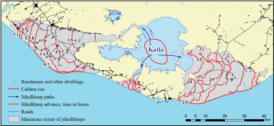
Predicted times for Katla flooding from 1918-sized jökulhaup. Click to enlarge. Source: Gudmundsson, M. T., G. Larsen, Á. Höskuldsson, and Á. G. Gylfason (2008), Volcanic hazards in Iceland, Jökull, 58(58), 251-268.
Summary in a single picture
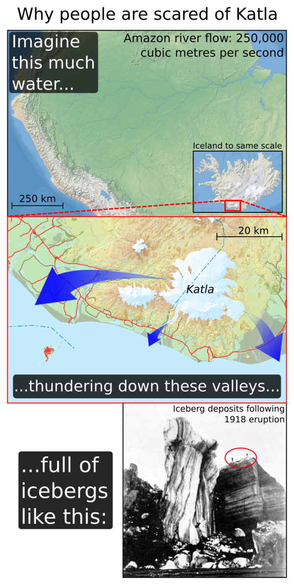 Sources: Amazon map – Natural Earth data; Iceland map – atlas.lmi.is; Iceberg image – Larsen, G. (2010), 3 Katla: Tephrochronology and Eruption History.


can the blast noise from Katla be heard in Widnes Cheshire UK?
Probably not. Eruptions through ice are surprisingly quiet. For example, check out this video of Eyjafjallajökull 2010; you can’t even hear the volcano over the noise of the aeroplane.
Pingback: Stuff we linked to on Twitter last week | Highly Allochthonous
Sooo how long ago did Katla last flood west? 800 years ago?
According to historic documents, all the jökulhlaups since AD 1179 have gone east, except for 1860, when a small part went south. That isn’t to say that a westward flood is now ‘due’, but it is important to remember that they can happen.
To answer the question in your title then, “because it’s a scary thing!”
I thought that the conventional translation of jokullhlaup was as “glacier vomiting”.
I’m just having this image of an Icelander on Sauchihall Street, shouting “hlaup! hlaup!”, instead of “hughie! hughie!”
Well, stranger things have happened. Frequently.
Pingback: Grímsvötn 2011 (Part 1): UK ash deposition from the biggest Icelandic eruption since Katla 1918 | Volcan01010
I am British and have lived in Iceland last 13 yrs, so I am a bit nervous that Katla has been having earthquakes. I live with my husband and 3 children in Hveragerði , just wondering how safe I am there ?! Worried about the flooding, ash being poisonous etc ! thanks Gaenor :/
Hi Gaenor,
Although Katla has been having earthquakes, they do not mean that an eruption is coming soon. Earthquakes are common at Katla, especially in the summer, and so far there haven’t been significantly more than in other years, and they are fewer and smaller than when the flood happened in 2011. You can see this in the top graph of this plot from the Icelandic Met Office: http://hraun.vedur.is/ja/Katla/katla_cal_qu_new.png.
When the next eruption eventually comes (and this might not happen for years), Hveragerði will be fine. It is quite far from the volcano and most of the time the wind blows from the west, so any tephra (ash + other debris) will be blown in the other direction. Any floods are most likely to affect the uninhabited sandur plains to the east of Vík, and the Civil Defence will shut the roads if there is any sign that an eruption is coming soon. If the eruption is large, and deposits lots of ash on land, it may be toxic for livestock who are eat it with the grass. It is unlikely to poison humans; during the Laki eruption, people were much more dependant on the land and couldn’t just eat pilsur. However, lots of ash blowing around in the air can be unpleasant for your eyes and lungs, so people may need protection at times.
The current warnings about Katla are not about an eruption, but about the risk of more meltwater floods. It is not a good idea to go hiking on Solheimajökull just now. This is because a flood could make the glacier move suddenly, or it could release gases that can suffocate you.
For more information, here is a link to some (fairly technical) articles on Volcanic Hazards in Iceland that the Almannavarnir have posted on their website:
http://www.almannavarnir.is/displayer.asp?cat_id=291.
John
Pingback: How to Keep Things Hot at Yellowstone and Katla: Just Add Water | Science Blogs | Tsangg
Pingback: How to Keep Things Hot at Yellowstone and Katla: Just Add Water | Nagg
Pingback: Bárðarbunga – waiting and watching | Volcan01010
Pingback: Bárðarbunga – turning Dettifoss into Niagara Falls | Volcan01010
Pingback: An Icelandic eruption 100 times more powerful than Eyjafjallajökull | Volcan01010
Pingback: Cluster of Big Earthquakes Rattles Iceland’s Katla Volcano – Rincon Tech News
Pingback: Cluster of Big Earthquakes Rattles Iceland’s Katla Volcano | iTruck NEWS
Pingback: Cluster of Big Earthquakes Rattles Iceland’s Katla Volcano – Global News
Pingback: Cluster of Big Earthquakes Rattles Iceland’s Katla Volcano | BeautyCribTV
Pingback: Cluster of Big Earthquakes Rattles Iceland’s Katla Volcano | Website Master Info
Pingback: Cluster of Big Earthquakes Rattles Iceland’s Katla Volcano – Technology and Computing
Pingback: Cluster of Big Earthquakes Rattles Iceland’s Katla Volcano – Cloud Up2date
Pingback: Cluster of Big Earthquakes Rattles Iceland’s Katla Volcano – Technology Up2date
Pingback: Natural disasters in the WORLD,Space,Science,History,Travel- RadioMetafora.ro
Hi!
I was wondering what happens if you’re hiking the Laugavegur trail when the eruption starts (as it can take hours to evacuate)?
I hiked it last summer and would like to return, but I’ve been a bit worried ever since I learnt that Katla could erupt any moment.
Thank you,
Best regards,
Petra
Pingback: Cluster of Big Earthquakes Rattles Iceland’s Katla Volcano | News