Queen of Icelandic volcanoes
Hekla is the Queen of Icelandic volcanoes, famed and feared throughout Middle-Ages Europe as news of her fierce eruptions percolated back to the continent. She was in the news again recently when GPS sensors detected ground deformation around the volcano. Although many mainstream media reports of the unrest were riddled with errors and hype, it is true that recent eruptions have come with little prior warning. Consequently, people in Iceland are keeping a close eye on her.
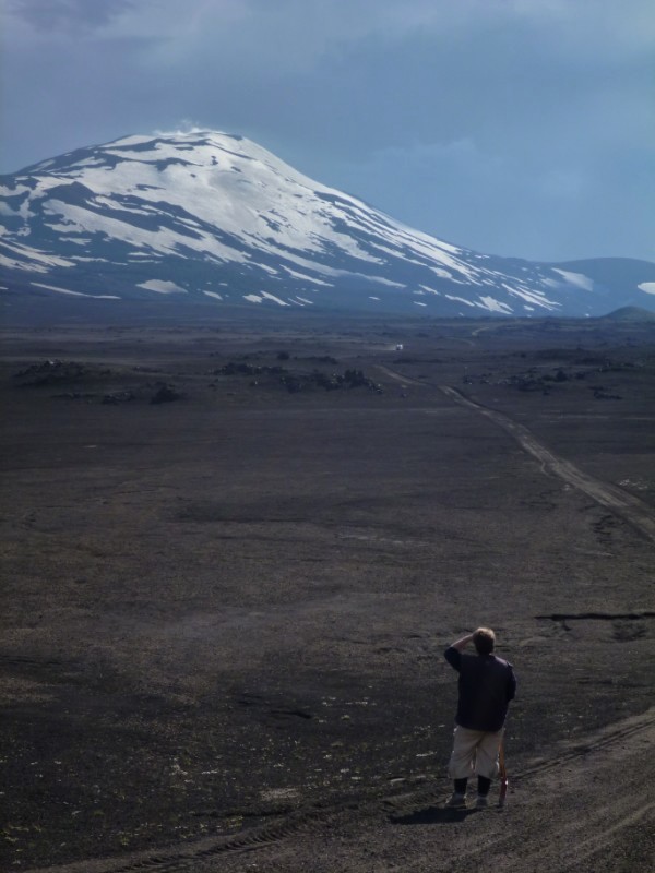
Hekla viewed from the north.
This post contains photos from recent fieldwork looking into some of her past eruptions. They give a taste of what she can do if she’s in the mood.
Tephrochronology
Tephrochronology is the use of tephra horizons in soils and lake cores as a dating tool. Tephra is the technical term for all the ash and pumice and rock fragments ejected from a volcano during an explosive eruption (strictly speaking, ash only refers to particles less than 2 mm in diameter). In Iceland, as elsewhere, this technique is an important method in working out the size and frequency of explosive volcanic eruptions in the past.
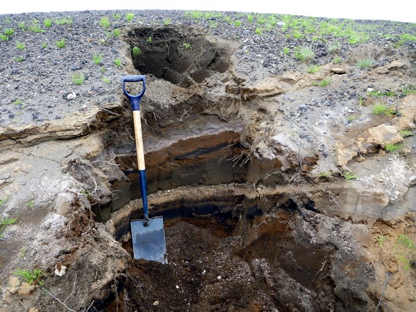
A tephra pit in south Iceland. In general, soil is brown and the light and dark bands are tephra horizons from volcanic eruptions. The black bands here are from Katla eruptions. The upper and lower pale-coloured bands are from eruptions of Hekla and Torfajökull volcanoes, respectively.
The Hekla 4 eruption
The Hekla 4 eruption (H4; estimated to have occured approximately 4000 years ago) was one of the largest explosive eruptions in Iceland since the Ice Age ended about 10,000 years ago. Around 5,600,000,000 cubic metres of tephra was erupted, which puts the eruption into Category 5 of the Volcano Explosivity Index, alongside Mount St Helens 1980 and Vesuvius 79 A.D. Ash from the eruption can be found across Scotland and Scandinavia, where it is an important tephrochronological marker.
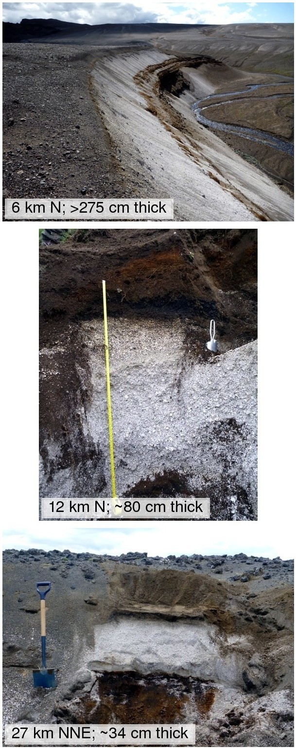
Soil pits containing Hekla 4 tephra across South Iceland. The layers consist of chunks of white, bubbly pumice and smaller dark fragments of older lava that were ripped from the volcano during the eruption. As you get further from the volcano, the layers get thinner and the chunks of pumice get smaller.
The scale of the eruption can be appreciated by tracing the thickness of the tephra layer across the surrounding countryside. The early parts of the eruption produced distinctive white rhyolite pumice that is easily seen against the brown soil.
Isopach maps
Isopach maps show the thickness of tephra layers produced in explosive eruptions. The isopach map for the H4 eruption was published by Icelandic volcanologists over 30 years ago, and was produced with data from hundreds of tephra pits all over the country. The total volume of the eruption can be calculated from the area contained between each of the contours of tephra thickness (isopachs).
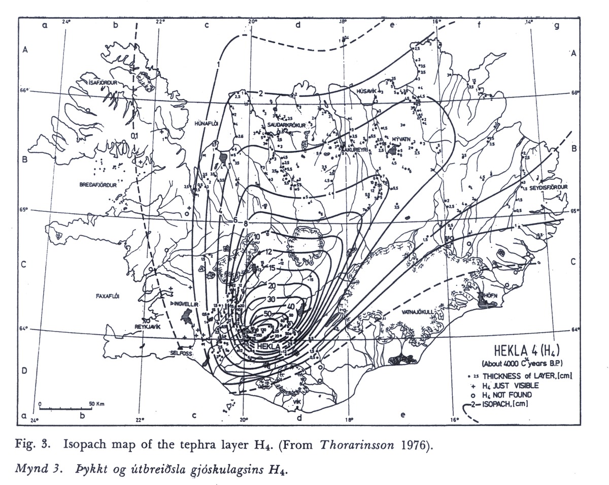
Isopach map for the Hekla 4 eruption. The contours give the thickness of tephra in centimetres. Most of the tephra was blown to the north of the volcano and over half the country received more than 1 cm of ashfall. Click on the image to see a larger version. Source: Larsen, Gudrún, and Sigurdur Thorarinsson. 1977. “H4 and other acid Hekla tephra layers.” Jökull 27 (27): 28-46.
By revisiting this work and sampling the tephra at many locations, modern methods can used to get an even better understanding of the eruption. In particular, by knowing the grainsize distribution in each sample, the total amount of fine ash produced can be estimated. It is fine ash (<64 microns diameter) that travels furthest from the volcano and interferes with air travel. If we know how much was produced in H4 then we can work out the likely consequences of a similar eruption.
The next eruption of Hekla
The next eruption of Hekla will probably not be as large as the Hekla 4 eruption, however. The most recent eruptions (in 1970, 1980, 1981, 1990 and 2000) were all much smaller. Each began with a short explosive phase lasting hours to days, followed by days, weeks, or months of lava production. The 1947 eruption was the largest Hekla eruption last century; the explosive part was similar in size to this year’s Grímsvötn eruption and tephra can still be found within peat bogs in the British Isles. The volcano then went on to produce smaller explosions and lava flows for the following year.
New rules on volcanic ash avoidance meant that disruption to air traffic due to the recent Grímsvötn eruption was much less than that caused by the Eyjafjallajökull eruption of the previous year, despite more tephra being produced in a short amount of time. These rules would also apply during any future Hekla eruption, so flight cancellations would probably number in the hundreds as opposed to the tens of thousands. This scenario may not sound too disastrous to European airport bosses, but that view is not shared in Iceland, where a northerly wind would dump the tephra across the fertile agricultural regions in the southern part of the country and a big eruption could put local farms out of action for years.
The Icelanders continue to watch their Queen of Volcanoes.


Pingback: Grant applications are hard work (includes LaTeX template) | Volcan01010
Pingback: Grímsvötn 2011 (Part 1): UK ash deposition from the biggest Icelandic eruption since Katla 1918 | Volcan01010
Pingback: Volcano suit / What to wear in Iceland | Volcan01010
Pingback: Fieldwork at the Holuhraun | Volcan01010