
![]() Squashed and squeezed between the Eurasian continent to the north and the northward-moving Arabian plate to the south, it is no surprise that Iran is a seismically active country, and in the past week it has been living up to expectations. Last Tuesday, a magnitude 6.3 earthquake at 10 km depth shook the western Bushehr region on the coast of the Persian Gulf; this Tuesday, a much larger magnitude 7.8 rupture occurred in the western province of Sistan Baluchistan, near the border with Pakistan.
Squashed and squeezed between the Eurasian continent to the north and the northward-moving Arabian plate to the south, it is no surprise that Iran is a seismically active country, and in the past week it has been living up to expectations. Last Tuesday, a magnitude 6.3 earthquake at 10 km depth shook the western Bushehr region on the coast of the Persian Gulf; this Tuesday, a much larger magnitude 7.8 rupture occurred in the western province of Sistan Baluchistan, near the border with Pakistan.
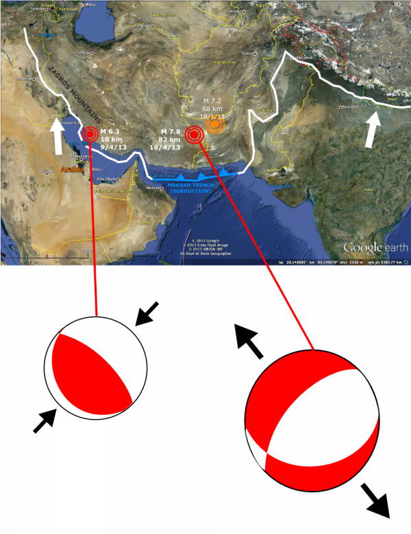
Location and focal mechanisms of the two recent large earthquakes in Iran. Data from the USGS.
The USGS originally reported the rupture depth for this week’s quake as 15 km, but as more data was analysed the estimate became much deeper, around 80 km depth (other solutions suggest it’s closer to 50 km). This meant that although this quake was powerful enough to shake buildings from Oman to India, the strength of the shaking immediately above the rupture was far less powerful than was originally feared. Although the mud brick buildings common in this region are not particularly resilient to earthquakes, the largest death toll reported so far is 34 people across the border in Pakistan.
The map above shows that both these earthquakes are associated with the collision of the Arabian and Eurasian plates, although there is a transition from a full-on continental collision in the west to a subduction zone (the Makran Trench in the east). However, the focal mechanisms for these two earthquakes are very different, last Tuesday’s M 6.3 indicating northeast-southwest compression and this Tuesday’s M 7.8 indicating northeast-southwest extension. The former is much more in keeping with what you’d expect at a collisional plate boundary than the latter, at least until you remember that the depth of the rupture makes it much more likely to have occurred in the subducted Arabian slab that must exist underneath eastern Iran and western Pakistan, rather than the folded and crumpled Eurasian plate we see on the surface. In fact, as I’ve also marked on the map above, in January 2011 a magnitude 7.2 earthquake with a very similar depth and extensional focal mechanism occurred around 250 km to the northwest of this week’s rupture in western Pakistan. The plot below, modified from Engdahl et al. (2006) shows both of these earthquakes fall within the projected confines of the subducted Arabian plate; the extensional focal mechanisms are probably therefore caused by either the pull of the down-dip slab, or some sort of plate bending effect.
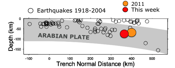
Rough shape of the subducting Arabian plate (shading added by me) based on the earthquake locations of Enghdal et al. (2006), with approximate locations of this week’s M 7.8 earthquake and the very similar M 7.2 event in western Pakistan, Jan 2011.
As I noted in 2011, the northwest-southeast axis of extension is considerably rotated from the north-south axis you would predict for either ‘slab-pull’ on, or bending of, a north-dipping slab, so some other forces may be at play; perhaps the faster collision of India to the east that forms the Himalayas is forcing some kind of lateral buckling of the Arabian slab.
I was also quite interested in last week’s magnitude 6.3, because it was located in the Zagros mountains: the main shock and aftershocks are located right amidst some of the beautiful folds for which the region is famous, traced out in aerial view by resistant limestone ridges.
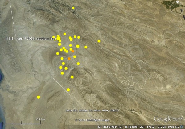
Location of last week’s M 6.3 in the Zagros mountains, with aftershocks and pretty, pretty folds. Data from USGS.
The Zagros region is also an example of thin-skinned thrusting, where a layer of weak rock – in this case a Cambrian evaporite – acts as a detachment, or décollement, which isolates folding and thrusting in the surface layers from the deeper parts of the crust. As such, you would expect seismicity in this area to be located on this decollement, or on thrust splays propagating up from it. A nice cross section across this region can be found in McQuarrie (2004), and indicates that the 10 km depth of the rupture is close to the decollement depth, but combining the information from the focal mechanism with this section suggests the rupture was on a NE-dipping splay fault. McQuarrie also suggests that most of the faults are associated with the cores of the folds observed at the surface, although it is hard to clearly see this from the aftershock pattern.
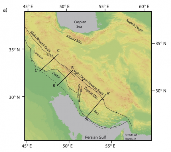
Map of Zagros Mountains. Cross-section A-A' is reproduced below. From McQuarrie(2004).
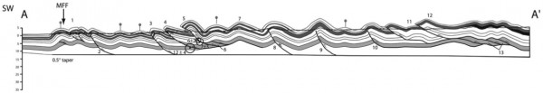
Balanced cross-section through Zagros fold belt in the same region as last week’s M 6.3 Earthquake. From McQuarrie (2004).
So it seems that Iran’s seismic week encompassed both shallow and deep collisional processes, on opposite sides of the country. And tempting as it is to look for some deeper reason for both of these earthquakes occurring within a week of each other, the Bushehr earthquake last week was probably too small and far away to have had any influence on the timing of this week’s rupture.


Links (2)-
-
Pingback: The Fukang meteorite. | Memo Of The Air
Pingback: The dimensions of natural disasters | Highly Allochthonous