![]() Around 3pm local time yesterday, there was a massive earthquake about 100 miles off the east coast of northern Honshu Island, Japan. Initially calculated to be a magnitude 8.9, it has since been upgraded: the current CMT solution at the USGS has it as a 9.1. Either way, this is the biggest instrumentally recorded earthquake Japan has ever been shaken by, and is one of the biggest ever detected: it’s up there with the 2004 Boxing Day earthquake, and like that earthquake it generated a large – and extremely damaging – tsunami. The footage from the Honshu coast almost defies belief.
Around 3pm local time yesterday, there was a massive earthquake about 100 miles off the east coast of northern Honshu Island, Japan. Initially calculated to be a magnitude 8.9, it has since been upgraded: the current CMT solution at the USGS has it as a 9.1. Either way, this is the biggest instrumentally recorded earthquake Japan has ever been shaken by, and is one of the biggest ever detected: it’s up there with the 2004 Boxing Day earthquake, and like that earthquake it generated a large – and extremely damaging – tsunami. The footage from the Honshu coast almost defies belief.
There is already lots of excellent coverage of this earthquake from the geoblogosphere: Callan Bentley has an excellent summary of the characteristics of the earthquake and the tectonics that generated it, and over at Georneys Evelyn provides some excellent explanations of the geological forces acting at subduction boundaries, and Japan in particular. A comprehensive list of other posts on the earthquake is being compiled by Silver Fox over at Looking For Detachment.
Nonetheless, I think there’s still a few issues that I can try to clear up:
Which fault actually ruptured in this earthquake?
Japan is situated in a complicated plate boundary region where three subduction zones meet. This particular earthquake is on the part of the boundary where the Pacific plate is being subducted west beneath the North American plate (yes, really: the not-particularly active boundary between the North American plate and the Eurasian plate runs through Siberia, down the western edge of the Sea of Okhotsk and through Japan). Unsurprisingly, the focal mechanism indicates compression, along either a shallowly west-dipping or a steeply east-dipping fault (primer on focal mechanisms)
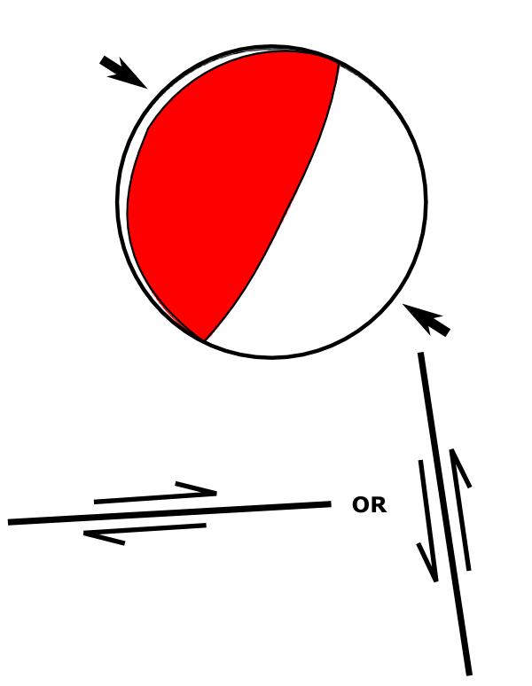
Focal mechanism for the main shock, and cross-sections of the two possible fault orientations
[Note: due to a severe foul up in my initial analysis, I’ve had to heavily modify this section. Contrary to what I originally wrote, the focal mechanism is entirely consistent with movement on the subduction interface, so is not a splay fault as I originally proposed. Many thanks to Kim Hannula and Eric Fielding, who both corrected me via e-mail. I am now heading to stereonet bootcamp]
This is consistent with motion on the subduction interface, and even though the rupture was 150 km behind the trench where the plate boundary intersects with the seafloor, it seems to have propagated most or all of the way to the surface, producing large, sudden vertical movement of the sea-bed and the overlying water and generating a tsunami.
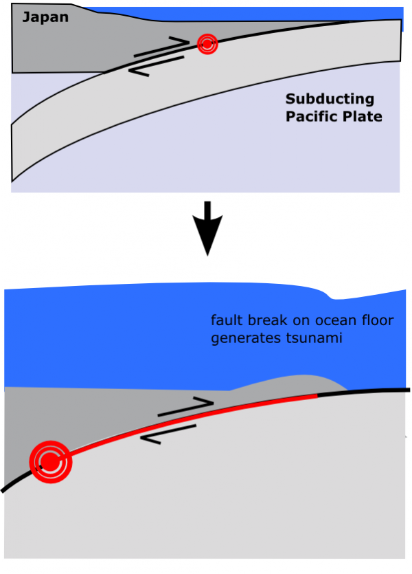
The rupture appears to have propogated to the sea-floor, generating a tsunami.
What’s with the changing magnitude estimates?
To estimate earthquake magnitudes, you look at the amplitude of the seismic waves it generates: the larger the amplitude of the waves, the larger the magnitude of the earthquake that produced them. However, in very large earthquakes, this relationship starts to break down, at least for the frequencies of seismic waves that are generally used to produce the quick magnitude estimates: they ‘saturate’, or stop increasing in amplitude as the earthquake magnitude does. This means that the magnitude estimates for the largest earthquakes will be somewhat underestimated until seismologists look at lower frequency waves, which are less susceptible to this saturation effect.
Were there foreshocks earlier in the week, and did they warn a bigger quake was on the way?
Yes to the first, no to the second. On Wednesday, there was a magnitude 7.2 earthquake in the same region as today’s earthquake, with a very similar-looking compressional focal mechanism, which was followed by a number of smaller >M 5 quakes, including three M 6-6.1 events (the focal mechanisms for two of these are also shown in the figure below; there is no focal mechanism available for the third). These were mainly clustered in a region just to the northeast of today’s larger rupture, and within the much larger cloud of aftershocks that are still being produced by that event (at my last count, there have been more than 100 aftershocks of greater than magnitude 5, and almost 20 of greater than magnitude 6). Thus, in hindsight, these earthquakes were clearly foreshocks of today’s main event.
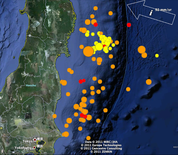
Map showing location of seismicity on 9th and 10th of March (yellow circles) compared to March 11's ~M9 (largest orange circle) and its aftershocks (other orange and red circles).
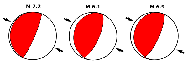
However, there was no way of telling this in advance: there is nothing particularly “foreshock-y” about foreshocks beyond the fact that they end up being smaller in magnitude than the main shock they precede. In fact, if you plot the last few days of earthquakes over time, you can see that, on Wednesday and Thursday, seismic activity seemed to be dying down again in the wake of Wednesday’s 7.2 quake.
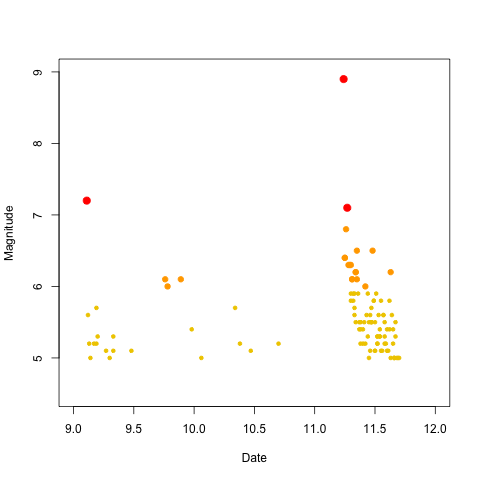
Magnitude of earthquakes (M5-6=small yellow circles, M6-7 orange circles, M7+ large red circles) off the coast of Honshu, 9-11 March.
What didn’t cause this earthquake?
In case you were wondering, this earthquake was not anything to do with:
- The moon (or the ‘Supermoon’, which is the woo-ified way of saying ‘the Moon, a teeny tiny bit closer to Earth than it is on average) – Erik Klemetti has a good dismantling of this one.
- The Christchurch earthquake – devastating as it was due to it’s location, this month’s M 6.3 earthquake in Christchurch was not that large in the grand scheme of things, releasing around 30 times less energy even than Wednesday’s 7.2 foreshock.
- Non-existent US government earthquake weapons
- The run-up to 2012 (we’re still way behind the 1960s)
Sadly, devastating events like this are a part of the way the planet we live on works. Despite claims and pseudo-predictions to the contrary, they require no special explanation beyond normal plate tectonics, with all of the unpredictability – on human timescales, at least – that that implies.


Comments (12)
Links (12)-
-
-
-
-
-
-
-
-
-
-
-
Pingback: Why are there Earthquakes and Volcanoes in Japan? In Response to: Magnitude 8.9 Earthquake & Tsunami in Japan | Global Posts
Pingback: More unique perspectives of the 8.9 quake « The Trembling Earth
Pingback: Japanese earthquake, tsunami, and nuclear safety: ‘NDR’ revisited « Geodoctor
Pingback: Aftershocks of the Sendai earthquake | Highly Allochthonous
Pingback: Yet Another Interview with my Dad, a Nuclear Engineer, about the Fukushima Daiichi Nuclear Power Plant Disaster in Japan | Global Posts
Pingback: USA: Science Bloggers Explain Earthquakes and Tsunamis · Global Voices
Pingback: Tsunami Video Roundup | Deep Sea News
Pingback: Reverberations of the Honshu tsunami | Highly Allochthonous
Pingback: Reverberations of the Honshu tsunami – Anne Jefferson – HighlyAllochthonous | Hating God - With due respect and all
Pingback: Review: StarTalk Radio “A Violent Earth” | GeoMika
Pingback: Etazonia: Mpitoraka Bilaogy Momba ny Siansa Manazava ny Horohorontany Sy Ny Tsunami · Global Voices
Pingback: Reverberations of the Honshu tsunami « Watershed Hydrogeology Blog