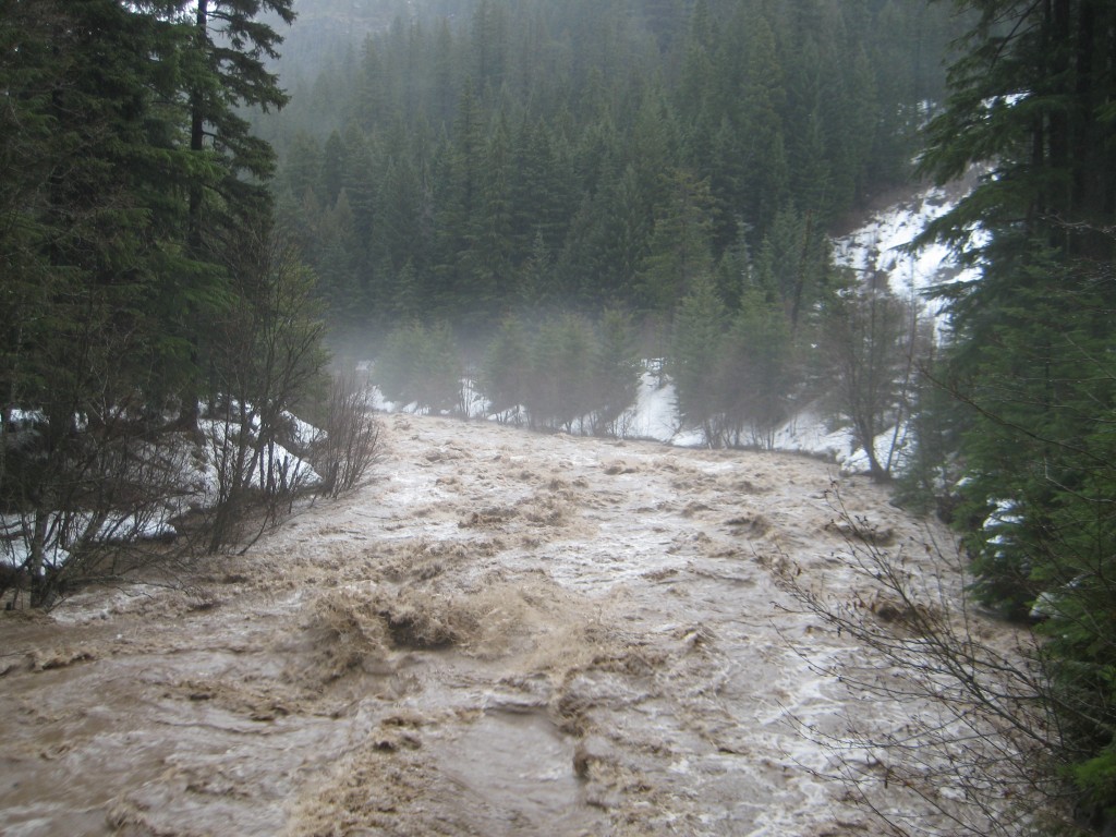
Flooding on the East Fork Hood River at the Tamanawas Falls trailhead, January 16, 2011. Photo by Sue Marsh and used with permission.
![]() It’s the middle of January. You’ve traveled to Oregon’s majestic Mount Hood for a weekend of skiing the snow- and glacier-covered slopes. On Saturday morning when you begin to head up the mountain from Portland, it’s warm and raining. “No problem,” you think, “it will be snowing at higher elevations.” (Thanks to generally decreasing temperature with increasing elevation, or the environmental lapse rate.) But it’s not. Instead, it is raining. Not just run-of-the-mill Oregon drizzle, either. It’s really raining hard.
It’s the middle of January. You’ve traveled to Oregon’s majestic Mount Hood for a weekend of skiing the snow- and glacier-covered slopes. On Saturday morning when you begin to head up the mountain from Portland, it’s warm and raining. “No problem,” you think, “it will be snowing at higher elevations.” (Thanks to generally decreasing temperature with increasing elevation, or the environmental lapse rate.) But it’s not. Instead, it is raining. Not just run-of-the-mill Oregon drizzle, either. It’s really raining hard.
That’s not just a made-up story. It happened last weekend. On January 15-16, 2011, Portland got ~40 mm (1.4″) of rain. Timberline Lodge, Mt. Hood’s most famous and highest elevation ski lodge, got 170 mm (6.76″). Of rain.
Rain on the mountain was thanks to warm, moist air being blown in from the Hawaiian Islands. This was a classic “Pineapple Express.” The extra-large helping of rain at higher elevations was the result of the orographic effect, in which mountains force air to move up in elevation, where it cools and can’t hold as much water vapor, so it produces more rain.
All that warm rain had to go someplace. And the first thing it hit on the mountainside was the snowpack. At the Mt. Hood SNOTEL site, 36 cm (14″) of snow depth were melted away by the warm rain between Friday and Monday. That contributed an additional 33 mm (1.3″) of liquid water to the festivities. So, something like 200 mm (8″) of water was loosed upon the the landscape over a two day period. (More at higher elevations, less at lower elevations.)
Some of that water probably soaked into the ground, but a lot of it ran off into the streams and rivers that drain the flanks of Mt. Hood. Below, I’ve reproduced the hydrographs of two of Mt. Hood’s Rivers to give the quantitative picture of what happens when that much water reaches a river in a short amount of time.
![CropperCapture[1] Hydrographs of Hood and Sandy Rivers for flood of January 15-16, 2011 (Data from USGS)](https://all-geo.org/highlyallochthonous/wp-content/uploads/2011/01/CropperCapture1.jpg)
Hydrographs of Hood and Sandy Rivers for flood of January 15-16, 2011. The Sandy River (at the Marmot gage) drains Hood's west side, and the Hood River (at the Tucker Bridge gage) drains its northeast side. The gap in the Sandy River data represents an equipment failure or lack of an adequate rating curve at high water levels. (Data from USGS)
I could wax lyrical about what I see in those hydrographs, but I think the following two videos do a pretty good job of showing the amount of sediment (and large trees and roadway) that 350 m3/s can carry out of the mountains.
The Sandy River from alexandra erickson on Vimeo.
The thing about this past weekend’s flood, though, was it’s utter unremarkableness. A few ill-positioned streamside cabins and some roadways bit the dust, but most infrastructure was fine. Because floods like this happen quite frequently. In the graph below, I’ve reproduced the same hydrographs for this past weekend. But now I’ve added the most recent good-sized flood (November 2006, which I have blogged about before), and the rather larger 1996 and 1964 floods for comparison.
![CropperCapture[3] 2011 flood hydrographs in comparison to 2006, 1996, and 1964 peak flows for the Hood and Sandy Rivers, Oregon (USGS data)](https://all-geo.org/highlyallochthonous/wp-content/uploads/2011/01/CropperCapture3.jpg)
2011 flood hydrographs in comparison to 2006, 1996, and 1964 peak flows for the Hood and Sandy Rivers, Oregon (USGS data)
Oregon builds for flowing water much more powerful than last weekend’s flood. So while the wet weather created some localized problems, the videos above clearly show that this sort of event mostly just makes for something different to do on the weekend (flood-watching in lieu of skiing).
What would have changed that equation is if large or numerous landslides had been triggered by the rain and running water, like they were in a similar event in 2006. When flowing water becomes flowing car-sized boulders, the damage gets much more serious. Thankfully, Mt. Hood had a healthy snowpack that could sustain 36 cm of rapid melt without exposing the loose sediments that give rise to such boulder torrents. Plus, the places most likely to produce landslides had done so only four years earlier, so they may not have been as overloaded with sediment ready to move. Nonetheless, as warmer winter temperatures reduce snowpacks, bring more winter rain, and force glaciers to retreat (exposing more loose sediment), it’s likely that the mid-winter rain storms of the future will produce more landslides along with the floods. And, as one unfortunate Mt. Hood ski resort learned in 2006, landslides don’t just force skiiers into becoming flood watchers, but can ruin the whole season.


Comments (1)
Links (1)-
Pingback: Stuff we linked to on Twitter last week | Highly Allochthonous