![]() Without question, the most important geologic experiences in my career have been floods. I grew up on the Upper Mississippi River in southern Minnesota and decided I wanted to study rivers during the Great Flood of 1993. Four years later, when I was a senior in high school, the Mississippi River flooded again with an even higher crest in my area, but it was overshadowed by the record-breaking floods on the other side of the state. In 2001 when I moved back to Minnesota to study for my Water Resources Science MS degree, the Mississippi and Minnesota Rivers flooded again – just to make sure I was paying attention. Days after I moved to North Carolina in 2007, my hometown got up to 43 cm of rain and there were devastating floods on every creek in the area. And as I write this post, southeastern Minnesota and western Wisconsin are flooding again – thanks to up to 25 cm of rain on already saturated soils. So you could say I’ve grown up with big floods, maybe even gotten used to them as a fact of life. But I never expected to experience one during a trip to one of the most arid regions on earth – Australia’s Great Red Centre.
Without question, the most important geologic experiences in my career have been floods. I grew up on the Upper Mississippi River in southern Minnesota and decided I wanted to study rivers during the Great Flood of 1993. Four years later, when I was a senior in high school, the Mississippi River flooded again with an even higher crest in my area, but it was overshadowed by the record-breaking floods on the other side of the state. In 2001 when I moved back to Minnesota to study for my Water Resources Science MS degree, the Mississippi and Minnesota Rivers flooded again – just to make sure I was paying attention. Days after I moved to North Carolina in 2007, my hometown got up to 43 cm of rain and there were devastating floods on every creek in the area. And as I write this post, southeastern Minnesota and western Wisconsin are flooding again – thanks to up to 25 cm of rain on already saturated soils. So you could say I’ve grown up with big floods, maybe even gotten used to them as a fact of life. But I never expected to experience one during a trip to one of the most arid regions on earth – Australia’s Great Red Centre.
Early in the year 2000, I was studying abroad in Wollongong, Australia and some friends and I made fantastic travel plans for the Easter holidays. We were going to fly into Alice Springs, see Uluru, Kata Tjuta and then head north to Darwin and Kakadu. We flew into Alice Springs on 20 April – and much to our surprise when we got off the plane, it was raining. And raining. And raining. It proceeded to rain for at least the next 3 days – maybe longer. My memory blurs a bit from endless hours being trapped in a soggy hostel with hundreds of other stranded holiday-makers in a town that was not equipped for tourists to do much more than pass through. And a town that was in increasing danger of going under water.
But let me back up a bit. Alice Springs is in pretty much the dead center of Australia. It gets, on average, less than 30 cm of precipitation per year. The Todd River flows through the center of town. Though flows might be too generous a word for a river on which there is a famous boat race that has to be canceled if there is water in the river. Participants run down the river channel in bottomless canoes. Seriously. The river is dry more than 95% of the time.
Alice Springs is also a major place for tourists who want to visit Uluru (Ayers Rock) to fly into before taking a 400+ km bus ride to the rock itself. There is one road to the south, towards Uluru. There’s one road to the north, toward Darwin. As far as I know, there are no roads toward the west, because in that direction lies nothing but desert. And there’s one road to the east, toward the Alice Springs airport and points beyond. After our first night in Alice, every road except the one to the airport was underwater. Planes kept bringing in hapless tourists like ourselves, but there was no way for any of us to get out.
Because the waters kept rising. For you see, on 20 April, Cyclone Rosita had made landfall near Broome, on the northwest coast of Australia, as a Category 5 storm. It then tracked across the Great Sandy Desert and towards the headwaters of the Todd River and Alice Springs itself. And when large amounts of rain fall in a short time in an arid environment, boy do the rivers run.
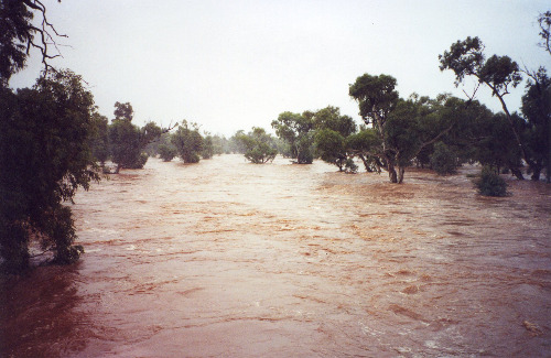
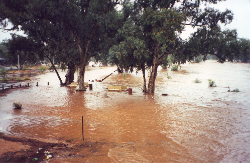
Todd River in Alice Springs, 21 April 2000 (photo by A. Jefferson, from the only above-water bridge in town)
My recollection is that the photo above was taken about the time of peak flow on 21 April 2000, and it shows that the buildings in town were largely spared. However, I don’t have any photos from 22 April, which I remember as a miserably wet day during which my friends and I huddled in the hostel and played a lot of Uno.
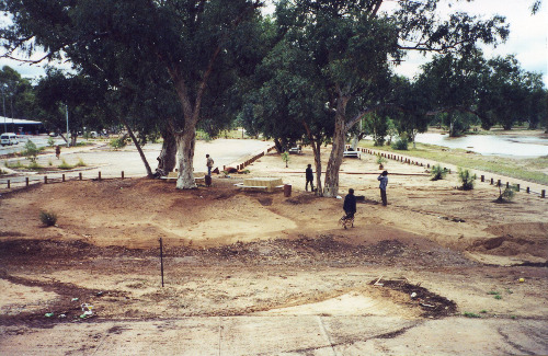
Once the rains finally dwindled, sometime on early on 23 April, the Todd rapidly receded and by mid-afternoon I got the above and below shots of areas that had been underwater just a few hours before. I particularly like the picture below because it nicely illustrates differential deposition and erosion associated with flow obstructions.
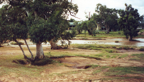
Scour around a riparian tree with the receding Todd River in the background, 23 April 2000 (photo by A. Jefferson)
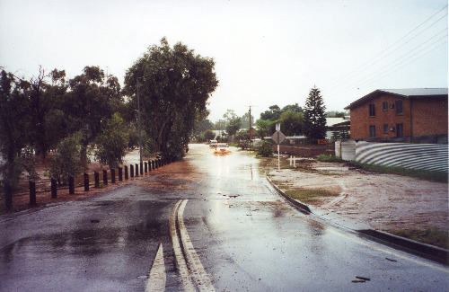
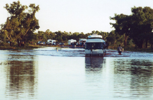
Finally, on 24 April, we were able to get out of town and head south to Uluru. But while the floodwaters had passed in Alice, there was still LOTS of water in the desert. As desert roads aren’t always equipped with bridges, there were several places where the vehicles had to ford slow-moving or ponded water. Even in college, I was enough of a river rat to know that driving across a flooded roadway is a great way to get yourself killed and I remember lots of consternation at the prospect of the water crossing pictured below. But we were literally in the middle of nowhere so my options for abandoning the trip were limited and after watching at least a dozen other vehicles ford the water, my friends and I got back on our bus and safely made it across the remnants of Rosita’s rain.



Comments (6)
Links (3)-
-
-
Pingback: When You Thought it was Safe. « Mythusmage Opines
Pingback: Important Geological Experience: Know Your Tools | Point Source
Pingback: Stuff we linked to on Twitter last week | Highly Allochthonous