A message from Brian Vanderkolk:
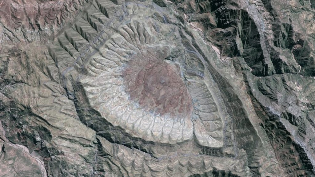
Having won WoGE 183 I choose a location that has intrigued me personally ever since I found it while browsing Google Maps. I pick this place because I don’t have the geologic knowledge to understand what I am seeing. It appears something amazing has happened here. I hope the winner and others will help me learn something new. North is up in this picture and eye altitude is about 20 kilometers.
![]()
Click the image for a larger version.
Anne says: First person to identify the latitude and longitude of the image, give a place name, and take a decent stab at why it might be interesting gets the honor of hosting the next round of the game. If you are not a blogger, you can still play, win, and then designate the blogger of your choice to host your image and the next round. I’m invoking the Schott Rule, to keep giving newcomers like Brian a chance to get in on the fun. The Scott Rule, means that you need to wait one hour after the post time to answer for each Wo(G)E round you’ve won in the past.
The Authors
Search this blog
Categories
Archives
-
Recent Posts
- In large earthquakes, the Earth moves for almost everyone
- And the ScienceSeeker Award for best physics, astronomy, or earth science post goes to…
- Weekend procrastination for geonerds
- The dimensions of natural disasters
- After the dam came out: The Cuyahoga River in Kent
- My class visits the Geology Department – by Geokid
- The intrusion of nature
- Echoes of Wenchuan: magnitude 6.6 earthquake shakes Sichuan province in west China.
Latest Comments
- On And the ScienceSeeker Award for best physics, astronomy, or earth science post goes to…:
- Silver Fox: Very nice! Read
- Carol Jefferson: Most excellent, Chris. Read
- Chenjian: Cool! Congratulations! Read
- Eric Bilderback: As noted in other comments, the three axis plot is a graphical representation of some of the... Read
- Damian Grant: This is exactly the representation of risk used in the risk literature, where Vulnerability is... Read
- Gaythia Weis: I agree that vulnerability is key. This could be quite useful in such things as future development... Read
- Anne Jefferson: The Pennsylvania and Ohio canal was constructed around 1840 and went out of use in ~1857. A... Read
- Lab Lemming: How long since the locks were navigated? They look early 1800′s from the channel size. Read
Geotweetage


Hi,
I found this pretty fast.
19¬? 3’24.88″Z
65¬?25’40.89″W
I ist situated in Bolivia. Looking to the picture, You see it must be in an arid environment in an external zone of a mountain chain. So, I could already focus on mountainchains in arid zones. Comparing the colors, is suspected somehow it to be lying in the andes mountains.
And bingo, found it pretty fast
Geology of the area: Looking at the layering I would say undulating layers forming a hollow area in the center with in the center preferred erosion following the layering, so you get the strange circular form.
But… looking up “Serranias de maragua” which is indicated on Google Earth it seems to be a volcanic “crater”.
see http://www.thefreelibrary.com/Sucre-a0147524308
The hike to the edge of the crater from Chaunaca takes another two hours, minimum. From Chaunaca take the trail going south through the fields rather than along the road. Once at the crater’s edge, use binoculars to pick out the obsidian deposits that are always on the surface and sparkle in the sun like black glass. This rare rock was usually chipped into knife blades and was highly prized by indigenous people from Alaska to Tierra del Fuego Tierra del Fuego , separated from the mainland by the Strait of Magellan. . Other things of interest in the crater are stalagmites and stalactites that indicate there was once a cave here. Without binoculars you can see the green and red hills that blend together to form an arch called the Serranias de Maragua. The green is from copper deposits and the red is from iron. Any of the other colors are from rarer mineral deposits and plants. The occasional dots that move along the landscape are people dressed in the best of weavings.
Well done Erwin for finding this, however I wouldn’t describe this as a crater feature and it certainly isn’t a volcanic crater. It seems to be more a rather round-looking synclinal structure, where at least three synclinal fold axes meet; one in the north with a fold axis trending roughly NNW-SSE, one in the west with a fold axis trending roughly E-W, and one in the south-east with a roughly NW-SE trending fold axis. The fact that many of the geological structures surrounding the syncline are anticlinal structures further confirms this structural form, as does the fact that it is within the upper-reaches of a foreland fold and thrust belt.
Thanks Erwin for locating the structure: I am at 2 m from Dan and he was getting mad trying to find it.
People call Maragua a “crater”, because it resembles a circular meteoric impact, but, as Dan, I also support the “syncline solution”. This is a tectonic structure rather than a crater. We can clearly see the attitude of the bedding, dipping towards the center of the structure. The structures formed in a meteoric impact, leading to the genesis of a crater, are usually in the other direction, like a domal structure where the beds dip toward the outside are of the crater.
Good sight!
Jorge
Wow. I guess that wasn’t that hard. Erwin, you used much the same technique I did to find Bullengarook – in my case it was the color of the forest.
I too doubt the volcanic idea, even though I am buy a rank amateur. I understand the concept of synclines and anticlines. That’s why I was perusing this area so much one day. But this structure just baffled me.
I would love to find some information or a paper giving theories on how these synclines came together this way. I’m somewhat reminded of a couple locations in the desert north of LA, specifically along the San Andreas. Those being The Devil’s Punchbowl (great day hiking) and Vasquez Rocks (where Captain Kirk fought a Gorn). In each of these cases I believe there was a small crustal block that was rotated and tilted while the main blocks slid by each other in lateral motion.
Brian
Yes Dan,
I agree completely with your opinion about the geologic structures creating this unusual round topography.
I mentioned the crater because that was what I found on the web about “Serranias de maragua”.
I also suspect the “crater” origin to be wrong.
Check also this view on the inner side
http://static.panoramio.com/photos/original/14209550.jpg
Found some more info:
http://www.panoramio.com/photo/14384697
EddyBaldellon, on November 17, 2008, said:
No es un crater volcanico, es una depresi??n estructural por plegamiento, conformando el sinclinal de Maragua, rocas sedimentarias de edad Cretacica con huellas de dinosaurios y fosiles marinos, flujos de basaltos intercalan con los sedimentos.
Looking up “sinclinal de Maragua”, found this thesis about the sedimentology and stratigraphy of the surrounding region.
http://etd.lsu.edu/docs/available/etd-0619102-182614/unrestricted/Fink_thesis.pdf
So Brian, here you have something to read about the origin
Hey! Thanks for finding that PDF. Looks like I’ll have some reading to do this weekend.
Brian