
It looks like a good number of the guesses for last week’s geopuzzlewere along the right sort of track. The most obvious topographic feature in the Google Earth image I posted is a patchwork of narrow linear ridges, which tend to either have an approximately northwest-southeast trend (I’ve highlighted some in red in the interpreted image below), or a northeast-southwest trend (yellow).
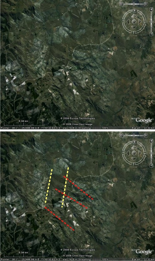
What makes these ridges stand out is a lithological difference – a change in the composition of the underlying rock. Whilst most of the basement rock in this area is granite belonging to the Barberton Greenstone Belt (making it somewhere between 3 and 3.5 billion years in age), the ridges are made up of a more basaltic igneous rock called dolerite, which is more resistant to weathering. Each ridge is a dike, a steeply dipping igneous intrusion (as opposed to a sill, which is a shallowly dipping intrusion) formed when hot magma is injected into subsurface rocks, cooling and solidifying without ever being erupted at the surface.
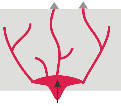
The fact that these dikes have a number of preferred orientations in this area indicates that they record several intrusive events. A pulse of magma ascending from below branches out as it forces its way upwards through the crust, seeking and exploiting weak points.
This produces sets, or ‘swarms’ of dikes that can extend over a fairly wide geographic region. Often all the dikes in a particular set will have the same, or a similar, orientation. This is due to a combination of factors. Many rocks will fracture more easily in particular directions, either due to the original lithology or as the result of a fabric imparted by later deformation. The tectonic stresses currently being applied to the part of the crust being intruded will also have an effect: for example, where the crust is extending dikes will tend to parallel the direction being formed. So the two different trends we see here represent two separate volcanic events. In fact, it’s possible that there are more than two; just like faults can get reactivated, new batches of upwelling magma can exploit the same structural weaknesses, leading to sets of intrusions with similar orientations but different ages (for example, in the very north of the image above, it looks like there are a couple of dikes with a slightly more NNW orientation than the ones I’ve marked in red).
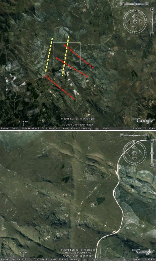
The only way to know for sure how old the different swarms are is to radiometrically date the dolerite, but you can get some idea of their relative ages – which ones are older and which ones are younger – by looking at cross-cutting relationships. If we zoom in on an area where the one of the northeast-trending dikes intersects with a couple of the north-west trending ones, its pretty clear that the former cuts through the latter, meaning that the northeast-trending dikes are younger.
So, other than showing yet another cool geological thing you can do with Google Earth, do these dike swarms have any wider significance? As I found out on a recent field trip to the area we’re discussing, the answer is a definite ‘yes’. My companion on this trip is working on a project which is trying to identify, and date, the various dike swarms found on all the different continents. Working out the number, timing and extent of the diffferent volcanic events which have shaped a particular piece of the planet is important in itself, but the real fun starts when you have read the “magmatic barcodes” for several continental fragments, and are able to compare them. Because when you start seeing periods of Earth history where these barcodes match up – in other words, where you see a sequence of intrusive events of the same age – this is a clue that during that time, the bits of crust in question were close enough to each other to be invaded by the same pulse of magma, and thus even if they are widely separated now, at one point they were merged together in an ancient supercontinent.

I think this is a neat example of how something apparently quite mundane can turn out to be so useful. After all, it’s not like the intrusions we’re talking about are in any way special; so who would have thought that this mess of ridges could hold the key to reconstructing past geographies?


Nice plan for content warnings on Mastodon and the Fediverse. Now you need a Mastodon/Fediverse button on this blog.