
If I’m ever going to talk about my own research in any detail, I’m first going to have to explain a little (or a lot) about the field I fell into almost by accident, paleomagnetism. Literally ‘ancient magnetism’, paleomagnetism is the study of the signals left in volcanic and sedimentary rocks by the Earth’s magnetic field; signals which can be preserved over millions of years of geological time. Paleomagnetic and other rock magnetic measurements are typically quick and non-destructive, and can potentially be usefully applied across the earth sciences – in fields as diverse as tectonics, geochronology, paleoclimate, and physical oceanography.
So, what is the nature of the Earth’s magnetic field? The shape and intensity of the field fluctuate over time, as records of secular variation – the changing position of the magnetic north pole with respect to the geographic north pole over the last few hundred years – illustrate. However, if you average these variations over a few thousand years, to a first approximation the field closely resembles a dipole centred near the axis of rotation.
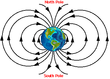
The shape of this field should look familiar to most people: it resembles that of a giant bar magnet (in a bizarre historical co-incidence, one of the first people to realise this, William Gilbert, was born in the same town – Colchester – that I was). However, this does not mean that the geomagnetic field is generated by a giant bar magnet at the Earth’s core. For a start, it’s much too hot (~5-6000o C) in the core for any material to retain a permanent magnetisation; the effect is dependent on long-range interactions between unpaired electrons, which are destabilised by too much thermal energy. The short-term variability of the field expressed as secular variation, and the fact that the it can reverse polarity (see below), are further indications that some other, more dynamic, process is responsible. In fact the ultimate source is thought to be convection of liquid iron in the outer core (a subject worthy of its own post, which I may supply in due course).
What it does mean, though, is that the common school physics demonstration of the way iron filings align around a bar magnet can be scaled up to describe the behaviour of compass needles at different places on the surface of the earth – in both cases they align parallel to the magnetic field lines curving from south to north pole (because magnetic polarities were first defined with reference to the behaviour of compass needles, the current magnetic north pole is currently located near the geographic south pole).

This means that although a compass needle will always align north-south in the horizontal plane, allowing us to reliably calculate bearings, in the vertical plane the inclination (or dip) of the magnetic vector varies with latitude, from almost horizontal at the equator to vertical at the poles. Also, a compass needle will point downward in the northern hemisphere, and upward in the southern hemisphere. If we want to, the direction of the magnetic vector in the vertical plane gives us information about our latitude on the Earth’s surface.
So much for the signal, what about the recorder? Ferromagnetic minerals such as magnetite, which are capable of storing the direction of an applied magnetic field even after it has been removed, are common in many volcanic and sedimentary rocks, and in the right conditions record the direction of the magnetic field at the time they form. In igneous rocks, these minerals crystallise directly out of the lava as it cools. Below a certain temperature (~600oC) the interactions which make magnetite ferromagnetic become stable, so the crystals become magnetized parallel to the direction of the extant geomagnetic field. In accumulating sediments, the magnetic moment of ferromagnetic minerals will align with the geomagnetic field as they settle, and this orientation is “locked” in after the sediments are compacted and lithified. In both types of rocks, this alignment can be preserved as a remanent magnetization over millions of years of geological time.
What can this record tell us? Quite a lot, actually. If you sample a sequence of rocks of different ages at the same location, it’s almost certain that you’ll see changes in the direction of the recorded magnetisation over time. This information can be put to many uses, including:
- Reconstructing continental drift.Changes in inclination indicate a change in location relative to the northern geographic pole over time, which is evidence for movement of the continents. For example, in the UK, Devonian (~400 million year-old) rocks have magnetizations with a very shallow inclination, indicating that they formed very close to the equator. This cheerfully coincides with the fact that most of the Devonian Rocks found in Britain are part of the Old Red Sandstone, which appears be formed mainly from sediments eroded from a dry, desert-like landmass quite unlike my present green and pleasant homeland. In contrast, here in the sunny and lower-latitude climes of South Africa, the steep inclinations measured in the Permian and Triassic (~250 million year-old) Karoo sequences explain the clear signs of glacial erosion affecting these sequences.
- Dating sequences using magnetostratigraphy. If you measure a continuous sequence of rocks, spanning a few tens of millions of years, you will make the surprising discovery that every few million years on average, the inclinations change polarity. Rocks in the northern hemisphere will not record a downward pointing magnetization as they would if they formed today, but an antipodal, upward pointing magnetization; inclinations from rocks in the southern hemisphere are likewise reversed. This is evidence of polarity reversals, when the two magnetic poles switch geographic location: the north pole goes to the south pole and vice versa.
Because geomagnetic reversals are globally synchronous events, occurring at the same time everywhere on the planet, finding a sequence of reversals in rocks of a similar age allows each sequence to be precisely correlated to the other, with the reversal boundaries acting as common age markers. This allows the correlation and dating of rock sequences worldwide. The striped magnetic anomalies on the ocean floor give us a continuous record of reversals going back almost 200 million years, which is the basis of the geomagnetic polarity timescale. - Measuring crustal rotations. This was a major part of my PhD. If you measure the remanent magnetization direction of 5-20 million year old rocks from New Zealand, you will find that in many places, the declination (the orientation of the magnetic vector in the horizontal plane) has changed substantially, so that instead of pointing north, they point north-east or east. In other words, the blocks of crust that make up New Zealand have rotated almost 90o clockwise in the last 20 million years. This type of deformation is very common in areas where deformation is spread across a wide zone of faulting, and without palaeomagnetic measurements, observing it, much less measuring it, would be very difficult.
So, one question remains to be answered: why “palaeomagic”? Well, it does almost seem like magic sometimes: you can’t see a remanent magnetisation, you can’t feel it or smell it, and it is often a property of only a tiny fraction of the mineral grains in your sample. Also, the post above sketches over the details of exactly how you measure a remanent magnetisation. When I started my PhD, a study of tectonic rotations in New Zealand, I viewed palaeomagnetism as a simple tool: stick rocks in, get direction out. It turns out its not that easy. Some rocks guard their magnetic secrets jealously, behind a wall of present day overprints and remagnetisations; it requires a lot of work and head-scratching to coax any useful information out. To illustrate, I’ll note that on submission three and a half chapters of my PhD thesis were devoted to unravelling the remanent magnetisation of New Zealand sediments. Only then could I actually start talking about the tectonic story, which was what I was actually interested in. Without knowing the palaeomagnetic story, however, there was no tectonic story; it was palaeomagic which transformed confusion into understanding.
(reposted with a fair amount of rewriting from ye olde blog).
More posts on palaeomagnetism:
Palaeomagnetism: from drilling to publication
A map of wonderful magnetic things
Where the Earth’s magnetic field comes from
Comments (5)
Links (1)-
Pingback: Where the Earth’s magnetic field comes from | Highly Allochthonous