Sediment and sea: from the heights to the depths

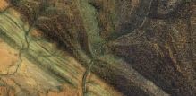
This study in blues and greys and browns, this combination of fuzziness and sharp edges, where is it?

It’s where land and ocean meet and mingle. A place where mud and silt and sand pause half way along an incredible journey that links the destruction of mountains to the creation of new land.

It’s an aerial view of the sea offshore from the Sundarbans, a vast area of tidal mangrove forest in India and Bangladesh. Sitting in the eastern elbow of the Indian subcontinent this is where the water from the Ganges and Tsangpo-Bhramaputra rivers enters the sea.

What makes the picture interesting is the dynamic shifting patterns of the sediment under the water. Water that when madly dashing down-hill had the power to carry sediment, but now it’s reached the sea it slows down and the sediment starts to pile up. Tiny clay minerals that were happily floating in suspension in fresh-water suddenly clumped together and sank in the salty sea1. The shape of the land here is caused by this process, plus the influence of the daily tides and the sinking of the ground as the sediment squashes down into itself. Fractally-frequent creeks and rivers snake their lazy way across near-flat terrain making it dangerously sensitive to changes in sea-level.

What is the sediment?

The sediment in this image came from the Himalayas. Some of came from near Mount Kailas and moved nearly 3,000km along the Tsangpo river tracing a line parallel to and north of the Himalayas. Cutting through the Himalayas at the Namche Barwa syntaxis the river cuts deep into the earth, eroding so deeply that the hot rocks beneath are flowing up to fill the hole, like jam oozing from a cut doughnut.

Map of the Yarlung-Tsangpo-Bhramaputra river. Image source.

Map of the Yarlung-Tsangpo-Bhramaputra river. Image source Wikipedia.

Often we are taught erosion as a gradual, calm almost civilised process. Not necessarily. Some of this sediment did indeed start as a small grain popped of an outcrop and rolled gently into a mountain stream. But more of it comes from boulders in glaciers scraping and scratching the rocks beneath, the resulting rock flour staining the glacial streams a milky blue. Or maybe from where the river cut a slope impossibly steep and a huge landslide smashed the rock into pieces. Or where the landslide dammed the river, until inevitably the water overtops it and a huge boulder-rolling crushing scouring flood sweeps down the valley.

Where the sediment came from

Sediment isn’t just generic stuff, it’s made of minerals, each with a character and a history of its own.

The sediment carries traces of the intense underground events that formed the mountains. Simple sand can be quartz crystals freed from ancient sandstones, born in the vanished Tethys ocean. Yet transformed in the meantime, crystals lattices rotated, grain boundaries switching and twisting as the rocks were heated and deformed.

More dramatic still is the story of the clay. Layers of silicates like illite or chlorite, packed higgley-piggledy with all manner of atoms, lazy and relaxed, suited for a soft low-pressure life on the surface. But these minerals are new, results of chemical weathering, a decline, a descent from what was once strong and pure2. Metamorphic minerals forged in the mountain’s heart: sparkling muscovite; kyanite, face lined from the pressure; hot-headed sillimanite, bushels of fibres bursting out the guts of the biotite it was feeding on.

These are strong minerals, forged under intense conditions. But under the attack of water, oxygen and sunlight they turn back into the clay the originally formed from. Some metamorphic minerals can survive longer at the surface, garnet, zircon and others form a very small part of the sediment load, but one that can tell us a great deal about where they’ve been.

Where it’s going

The sediment patterning the sea-bed in the image above has not reached the end of its journey. Sediment that joined a river perched 5 kilometers above sea-level is still nearly the same height again above the vast deep plains of the Indian Ocean.

Sediment flows downhill under water just as well as it does on land. Submarine channels are formed by turbidity currents – fast flows of sediment-filled water that travel vast distances down into the deep ocean. These undersea rivers have banks and trace sinuous patterns on the surface just like their cousins above land.

For over 20 million years, sediment flowing into the ocean from the Himalayas has formed the Bengal fan, a triangular pile of sediment that is 3000 km long, filling nearly all the sea-floor between the Indian sub-continent and south east Asia.
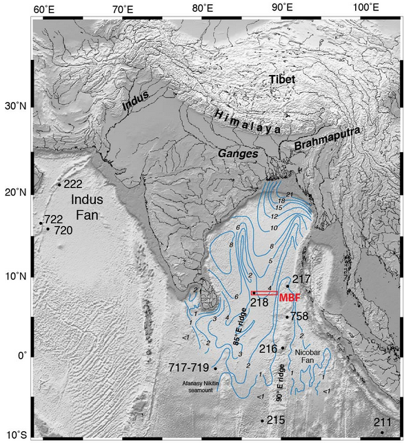
Blue lines are thickness of sediment in the Bengal Fan. Image Source.

Blue lines are thickness of sediment in the Bengal Fan. Image Source: IODP Red box is location of this year’s drilling.

This is no thin layer either. In places the pile of sediment is over 20 km thick. The oldest sediments are buried so deep they must now be metamorphic rocks3.

The total volume of the fan has been estimated to be4 12.5 million cubic kilometres. That’s enough sediment to cover the whole of Britain with a 100 km thick pile, or even the USA with over a kilometre5.

Assuming most of the sediment came from the Himalayas, which have an area of a million square kilometres, this implies that since the mountains were formed around 12.5 km of rock has been eroded off the top6. This makes sense – much of the High Himalaya is made of metamorphic rocks formed beneath the mountains and since exposed by erosion. 7.

Linking sea and mountain

This makes the fan a time-machine. Geologists who study the Himalayas, who want to understand its history, can use cores of sediment from the fan to understand what happened in the past. What metamorphic minerals were being washed off the mountains 20 million years ago? What age where they? Are there traces of the Monsoon (which is caused by the high Tibetan Plateau) at this time? The International Ocean Discovery Program (IODP) were drilling here earlier this year to answer exactly these questions.

The beautiful image we started with is from the boundary between land and sea, but the links between these two domains are many and important. Rocks that once sat kilometres above those now forming the modern High Himalaya now sit, shattered and decayed in the deep sea thousands of kilometres away. Erosion is focussed in the Himalaya partly due to monsoon rains, where moist air from the Indian Ocean is drawn onto the land by heating of air above the high mountains. Formation of the Indian Ocean crust pushed the Indian continent away from its location next to Africa to smash into Asia and form the mountains in the first place.

One day the plates will rearrange themselves and the Indian ocean will be destroyed and some of these rocks will once again find themselves on land, perhaps high in a mountain range waiting to go on another incredible journey back into the deep sea.

Scars, acne and others: circles on the ground

Looking is never just looking. When we gaze at something, we are not passive recipients of an image, instead our brain is constantly looking for patterns. If you are drifting over the earth, whether as an astronaut or via Google Maps then a simple shape such as a circle will ‘jump out’ at you. It turns out there are many different types of circle on the earth. They can be born in seconds or slowly, be mysterious, sinister, large or small. All are round.

Volcanoes

A classic volcano has an elegant cone1 and round crater at the top. If you’re lucky you’ll get multiple circles, like on Mount Kilimanjaro.

Or here in Italy, Mount Vesuvius gives us three circles. The first is the volcano itself, its steep sides rising above the towns surrounding it. The highest portion is relatively bare of vegetation and makes a smaller grey circle for the crater to sit in.

Craters form in different ways. Some are holes made by volcanic explosions. Crater Lake in the US is a glamorous example of this – what was once a volcano is now just a hole in the ground.

Calderas are round structures formed when a magma chamber (the big pool of molten rock deep under the volcano) empties. The rocks above collapse down into the now empty space.
Circular structures under volcanoes too. A volcano is typically a single point source of magma. With no real reason to be asymmetrical, any structures that form tend to be circular. For example here in Ardnamurchan in Scotland.

The volcano here was active 60 million years ago, so we are looking at the eroded roots of it. The rock structure used to be interpreted as a ‘ring dyke’ a circle of rock that filled the vertical cracks within a caldera. It’s now thought instead to be a saucer-shaped sheet of rock called a lopolith.

Bullet-holes

Volcanic craters are common on the earth, so scientists long assumed that the many craters on the moon were volcanic in origin. In fact they are impact craters, not planetary acne as volcanoes are, but bullet holes – scars that show we are living in a dangerous neighbourhood.

The most elegant scar is in Quebec in Canada, lake Manicouagan.

Like Ardamurchan above, this is not a fresh structure, but the eroded roots of an ancient impact. With it’s old rocks and ancient surface, Canada is rich in impact craters. Australia, another craton is good too, such as here at Gosses Bluff.

The biggest impact crater know is the Vredefort structure in South Africa.


Over 2 billion years old, this was once a huge hole in the ground – up to 9 km of rock were instantaneously removed when a huge rock from space hit the ground.

The Meteor/Barringer Crater in Arizona is small but much fresher, a mere 50,000 years. Here we are looking at the original hole in the ground, rather than deep structures now brought to the surface by erosion.

;

Fakes

Once we saw impact craters on the moon and thought they were volcanoes. Now we see round structures on the earth and assume they are impacts. Here are a few that formed in other ways.

The Richat Structure “eye of the Sahara” is formed of domed sedimentary rocks, perhaps uplifted by volcanic activity (volcanic rocks sit in the middle). Scientists have searched for ‘shocked’ minerals and other signs of impact and found none.

The Kondyor massif in eastern Russia is beautifully circular, but is not a crater. It’s an eroded volcanic structure.

Into the Anthropocene

Let’s end with a type of crater scoured by a massive fireball created by the same process that powers the sun. They appeared all over the earth for a few brief decades but (hopefully) they’ve stopped forming for good.

This sinister pair of holes were caused by nuclear testing on Enewetak Atoll in the Pacific. The left hand one was an island called Elugelab, until the explosion of the world’s first hydrogen bomb on the 1st November 1952.

Into the Third Dimension: using Google Maps to know what’s underground

Much of the earth’s surface is covered by sedimentary rocks. These form as sediment settles on the surface. As the types of sediment change – sand to mud to sand again – different layers are formed, some hard some soft. The patterns these layers make are responsible for some of the most interesting Great Geology in Google Earth.

Sedimentary layers start off flat1 but as plates collide and squash, they may be folded, like pushing the edge of a rug. The resulting 3-dimensional structures are later eroded and brought to the surface – itself a 3-D structure. The 2-D lines we see on the aerial images below are formed by the intersections of these different 3-D structures. This can make interpreting them a little difficult, as we’ll see.

Compare and contrast the next two images. First look at these smooth lines from Mexico.

Versus these zig-zag ones from Argentina.

Both of these patterns involve sedimentary rocks, but the causes of the wavy lines are very different. The secret is to work out the shape of land surface and then infer the shape of the sedimentary layers. Rivers are our friends here. In Argentina there is a clear relationship between them and the lines the layers are making on the ground. Every zig has a river in it and every zag is a little hill in between. The sedimentary layers are pretty much flat and the pattern of lines is caused by the shape of the land surface. Imagine cutting a wedge out of a layered cake – this is what it would look like.

In Mexico the pattern is mostly due to folding of the sediments. The beautiful curves and swoops are due to flat layers having been slowly buckled as the earth’s plates rearranged themselves.

Analysing these shapes and making sense of them is bread-and-butter for geologists. A bed-rock part of any geological education. Typically we use maps, but in desert areas photos tell everything we need to know.

One important trick geologists learn is to create cross-sections, drawing a slice through the earth to show how the folded rocks continue underground. One of the many types of sedimentary layer is a coal-seam, so you can see how this is not a purely academic exercise.

A good geological map will have symbols showing how many degrees tilt the layers have and in which direction they are pointing down. Without these we can’t do a proper cross-section. But using our friends the rivers and streams we can still tell a lot.

Here’s a nice fold. Imagine one of the layers is rich in valuable unobtanium and you want to mine it2. You can trace a line where the edge of it is, but which side of the line is the rest on? Think of it another way, are we looking down at an arch with the top sliced of (an antiform) or a basin (a synform)3 Should you sink your unobtanium mine-shaft in the middle of the fold or around the edge? If you get it wrong, you’ll choose the part where the valuable layer has already been eroded away from.

dipToTheNorthLook at the rivers (streams/creeks) that cross the layers on the top side of the fold. Notice a pattern? Every time the stream cross the layers, it makes a little V-shape, with the sharp bit of the V pointing North. A stream bed is always lower than its surroundings so it gives us a glimpse into the third dimension. Cut into the layer and it’s edge moves north – it’s deeper the further north you – it’s dipping to the north – it’s a tilted sheet that disappears under the ground to the north.

dipToTheSouthWe can check if we’re right because this a fold. For this trick to work the south side of the fold should have the opposite pattern. We are looking at a breached arch and the southern side should have the opposite pattern. It’s harder to see on this side (probably because the beds are tilted more nearly vertically and the effect is smaller) but indeed, our little V-shapes point the other way.

This 3-D stuff is hard work. Yet it’s something geologists have to be good at (maybe there’s some link with the strong anecdotal evidence that they tend to be left-handed). If you need some help, some of these Google Maps have good photos associated to help you get another view of the structures. Alternatively this post makes the same link.

Let’s leave you with some sheer aesthetic pleasure. Some totally flat layers turned into beautiful patterns by erosion.

Looking from the sky at diamonds

When a geologist looks at Google Maps images, we usually filter out any human activity. But in the case of mines, that would be a mistake – the holes humans dig can tell us about the geology.

What’s this? A big circular hole in the ground and large piles of bluish mine waste. The shadows are on the northern side, showing we are in the Southern hemisphere. This is the Letlhakane mine in Botswana.

And here’s another one, in the northern hemisphere. The hole here is half a kilometre deep (it’s an older mine, the Mirny mine in Siberia. They used jet engines to melt the soil so they could dig).

And again, the Diavik mine in Canada. Note that the hole is considerably deeper than the lake it sits in. They really wanted to dig that hole and yet most of the its contents are sitting in those big blue piles.

Finally the oldest example in the world, the Big Hole in Kimberley. The piles of dirt were put back in the hole, or covered in houses. Mining underneath here reached a kilometre depth.

We’ve been looking at some famous diamond mines. Diamonds form deep in the earth and those worth digging holes for only reach the surface via weird fizzy molten rock called kimberlite. This magma zips up from 100km depth to the surface in only hours. Travelling at depth along a narrow crack (or dyke in geo-speak1) when the magma reaches the surface it forms a carrot-shaped pipe. The magma solidifies, peppered with diamonds that formed at depth and were pulled up inside it.

The pipe is circular in cross-section, so as the miners dig out the kimberlite they leave a circular hole. The vast majority of what is dug out is waste – only the precious diamonds are extracted. Kimberlite is bluish in colour, as you can see from the piles of it above.

The Big Hole in Kimberley was the first kimberlite pipe ever identified2, in the 19th Century. Diamonds found before then were from placer deposits, river gravels that contain diamonds eroded out of kimberlite pipes. Diamond placer deposits were first discovered in India and then Brazil. But the biggest area for modern mining is on Namibia’s Skeleton Coast.

Southern Africa’s Orange river rises on the Kapvaal Craton, an area rich in kimberlite pipes. For 100 million years it has flowed across the continent into the Atlantic ocean, leaving thick placer deposits. These have since been pushed around since by wind and ocean waves to cover a wide area.

Starting at the beginning of the Twentieth Century, German settlers found diamonds and the government designated a huge area of land as Sperrgebiet – forbidden territory. This whole area remains closed, but active mining is concentrated the southern end, on the coast, where the diamonds are concentrated in ancient beach sands.

The mine here looks very different from the others, no round hole or blue kimberlite (but look for the regular patterns on the spoil heaps). Like the other mines, this one was caused by the desire for the beauty and strength of diamonds.