In areas of active mountain-building the middle crust can get hot and weak, like a soft jam/jelly filling in a sandwich. These squishy rocks are hidden from us by the cold rigid upper crust, so we wouldn’t expect to see them reach the surface, would we? Well, what happens if you overfill a sandwich and there’s a break in the upper layer? Nanga Parbat in the Karakoram Himalaya tells us what.
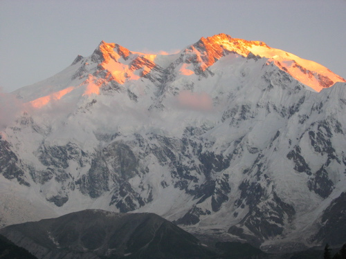
Nanga Parbat is one of only 14 mountains over 8,000m in height. It’s summit is a mere 25km from the Indus, a major river flowing off the Tibetan Plateau and then along the length of Pakistan. The mountain face between the two (the Rakhiot Face, above) is often called the world’s highest as there is a drop of 7,000m, from peak to river. Nanga Parbat sits at the Western syntaxis of the Himalaya, this is the point where the structural grain of the Himalaya changes from East-West to North-South. It corresponds roughly to the corner of the Indian plate (buried somewhere below), where the plate boundary swings around.
Nanga Parbat contains granites at the surface that cooled only a million years ago. Not lava but granite that was intruded at depth and yet is now at the surface. A active major thrust puts gneisses on top of river gravels. It’s estimated that 25km of crust has been eroded away in the last 10 million years (or 12-15km over the last 3Ma, take your pick).
A hard rain falling
In order to remove 25km of crust, you need a lot of erosion. That sort of erosion requires high rainfall and a major river to take all the bits away. Both of these things are present at Nanga Parbat. What is mind-expanding is the idea that the erosion and the tectonics are linked.
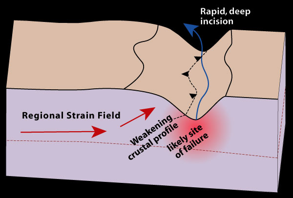
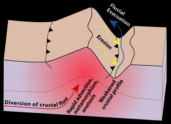
The “tectonic aneurysm” model (defined in Zeitler et. al 2001) suggests that the tectonics of the area are caused by the high rainfall and presence of the Indus river valley. Consider a river valley cutting deep into a mountainous area – it’s made a kilometres deep hole in the crust and this weakens the rocks below and either side of it.
To state the obvious, remove rock from the surface and the material below moves closer to the surface. This does two interesting things – firstly the reduction in pressure makes brittle rocks weaker. Secondly, the valley will change the thermal structure of the crust. Cutting a hole into the crust will bring hotter rocks closer to the surface (because the surface is lower). Then if the rocks beneath the valley start moving up (a process called advection) then they may move up so fast that they can’t cool down on the way. There’s more. Releasing pressure in very hot rocks (decompression) can trigger melting and granite production. The presence of melt reduces the strength of the crust by an order of magnitude. This means that the crustal flow will become easier as the rocks become weaker.
Erosion causes uplift which causes crustal flow which causes more uplift which causes more erosion which….. This positive feedback loop turns the initial weakness into a much bigger structure that affects the entire crust. The term ‘tectonic aneurysm’ refers to a medical condition where a weakness in an artery wall can cause serious medical problems as it gets bigger. My analogy of the overfilled sandwich with a cut in the top is more cheerful, but ‘tectonic aneurysm’ sounds much more sciency.
Egg or chicken?
The tectonic aneurysm model has also been applied to the Eastern syntaxis, at Namche Barwa in Tibet, where the Tsangpo river forms a deep gorge. These syntaxes are tectonic features, related to the corners of the Indian indentor, yet the aneurysm model regards a river gorge as thing that initiates extrusion. Why is there a connection between the two?
For me this is the most satisfying part of the model – the rivers flow across the syntaxes because of the geometry of the mountains – tectonics controls the location of the rivers which in turn influences the tectonics. Processes that affect the surface and those involving the entire crust are intertwined in a dance that lasts millions of years.
Consider the growth of the Himalayas. Rivers that used to drain off proto-Tibet into the Tethys ocean are now blocked by a mountain range, where India is pushing into Asia. These rivers start to flow parallel to and behind the mountains. Over time syntaxes develop and news rivers start to cut into them. Eventually these new rivers reach the old mountain-parallel ones and ‘capture’ them. The precipitation that has been stuck to the North of the Himalayas can now get through and the major river systems of the Indus and the Tsangpo-Bhramaputra can finally reach the Indian Ocean. At the ‘knick-point’ where these rivers drop sharply in altitude major gorges are formed. These ‘cut the sandwich’ and allow the weak hot middle crust to extrude out to the surface, forming some of the most fantastic scenery on earth.
The idea that patterns of erosion affect tectonics is a lovely illustration of the interconnectedness of the geosciences and is a current topic. A very recent paper in GSA Today by Paul Kapp and co-workers looks at wind erosion in the North of Tibet. They show significant rates of erosion and speculate a link with the (small-scale) tectonics of the area. It seems you don’t need big rivers (or indeed water) for the atmosphere to influence the way rocks deform.
The processes of crustal thickening that created the hot middle crust now extruding to the surface at Nanga Parbat affects all of Tibet. What happens to this soft material where it can’t reach the surface? Also are the syntaxes the only places the sandwich has leaked? Interesting questions. Someone should write a blog-post about them…
This post is part of my journey into the geology of mountains.
Further reading
![]() All of the papers listed here are publicly available right now. Click on the links and you get the entire paper no matter who you are. There are links in the text above, but here’s a list of the good stuff.
All of the papers listed here are publicly available right now. Click on the links and you get the entire paper no matter who you are. There are links in the text above, but here’s a list of the good stuff.
The good folk of the Geological Society of America make GSA Today available to all.
The GSA Today paper Zeitler et. al (Erosion, Himalayan Geodynamics, and the Geomorphology of Metamorphism) is the place to start for the tectonic aneurysm model.
Peter K. Zeitler, Anne S. Meltzer, Peter O. Koons, David Craw, Bernard Hallet, C. Page Chamberlain, William S.F. Kidd, Stephen K. Park, Leonardo Seeber, Michael Bishop, & John Shroder (2001). Erosion, Himalayan Geodynamics, and the Geomorphology of Metamorphism GSA Today
There is also a great set of papers on the Lehigh University website.
The Kapp et. al paper is in GSA Today, link to html version if you didn’t like PDF link above. DOI: 10.1130/GSATG99A.1
Kapp, P., Pelletier, J., Rohrmann, A., Heermance, R., Russell, J., & Ding, L. (2011). Wind erosion in the Qaidam basin, central Asia: Implications for tectonics, paleoclimate, and the source of the Loess Plateau GSA Today, 21 (4), 4-10 DOI: 10.1130/GSATG99A.1
For more information on Nanga Parbat geology, the 2006 paper from Jones et al. gives a good overview, plus a taster of what I’m writing about next.
Picture of Rakhiot Face from sunbeer on Flickr under Creative Commons Diagrams from Lehigh University ‘indentor corners’ project pages, with permission.


Awesome. I love this stuff. I find the coupling and feedbacks of the crust and its surface fascinating.
This essay was simply excellent, describing an exciting corner of geoscience research that I knew nothing at all about. Thanks for the introduction!
Pingback: Channel flow – hot rocks, big glaciers and the world’s tallest mountains | Metageologist
Pingback: Sediment and sea: from the heights to the depths | Metageologist
Pingback: Speed of metamorphism: cooling down | Metageologist