The May 2011 Grímsvötn eruption blasted ash and pumice and rock fragments (collectively known as tephra) through the Vatnajökull glacier, forming a massive plume up to 20 km tall. It was the biggest eruption in Iceland since Hekla 1947. Locally, ash rained down across southern Iceland turning day into night, while the finest grains were swept across the Atlantic to be deposited at least as far afield as in the UK. There are nice images of the plume and its consequences at The Boston Globe website.
Last month, the Institute of Earth Sciences of the University of Iceland and the Iceland Glaciological Society organised an expedition to Grímsvötn to study the deposits of the eruption. Following an adventurous journey across the glacier to the volcano (see Grímsvötn 1 – Crossing the glacier and Grímsvötn 3 – Bonus truck pictures), it was possible to see the deposits of the eruption, and thus what was in the plume, at first hand. This post shows what was erupted and explains some of what the deposits can tell us.
All this should be snow
The dispersal of volcanic ash is controlled by the wind. During the May 2011 Grímsvötn eruption, southerly winds blew the top of the plume northwards, while northerly winds blew the lower part to the south. It was the lower part that contained most of the tephra that was deposited near the volcano. Tephra is the technical term for all the ash and pumice and rock fragments that are thrown out in an explosive eruption (strictly speaking, ash only refers to material less than 2 mm in diameter).
This view, looking south from across Vatnajökull, should be dazzling white snow and ice all the way to the coast. Instead, it is black: a vast dark plain of pumice and ash extending tens of kilometres from the crater.
 Calculating the erupted volume
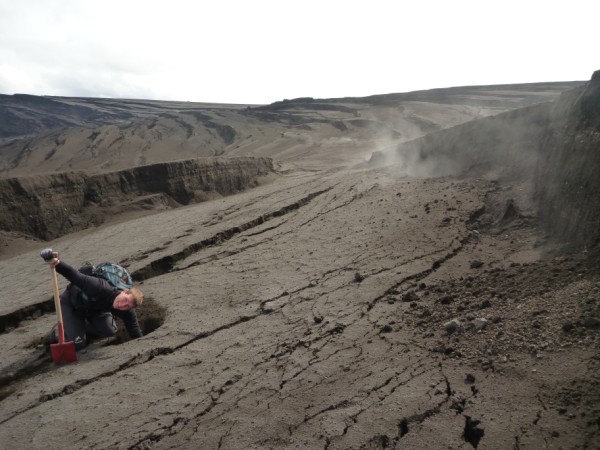
Digging through the black surface reveals the bright snow beneath. This makes it easy to measure the thickness of the tephra layer in different locations. A simple, but very important, question can be answered from the resulting map of tephra thickness: how much material was erupted?

At this location, if you keep digging, you will pass nothing but snow, ice and ancient tephra layers for over 700 metres before you finally reach the bedrock.
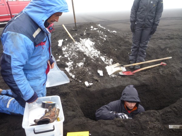
Closer to the crater, the tephra gets thicker and contains coarser, gravel-sized, pumice grains. At this site 8 km downwind of the crater, the deposit is nearly 2 m thick, and the hole took eight people over an hour to dig. It is clear why lone murderers favour shallow graves. A layer of ashy-hailstones that fell during the eruption has refrozen into an icy layer near the base. These were collected and transported back to Reykjavík in a freezer.
Other things that tephra can tell us
The deposits mainly contain ash and pumice: broken-up, bubbly rocks. The ash is fragmented pumice and looks like black sand or grit. All of this rock was hot enough to be liquid magma just moments before it erupted from the ground. A detailed look at some of the grains can tell us more about the eruption.
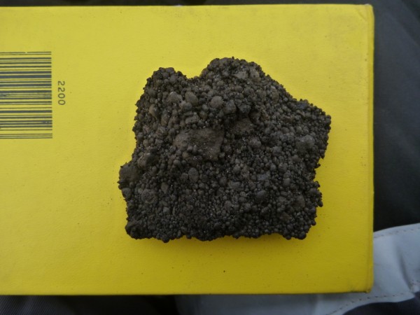
The first photo shows tephra from a layer that was full of smooth brown spheres called accretionary lapilli. If you cut one open, you find concentric rings (like in a gobstopper or an onion) of very fine ash grains. These form as the ash is swirled around in the turbulent plume. Helped by moisture, fine grains stick to the outside of the growing lapillus, building it up layer by layer.
It is important to understand accretionary lapilli because if these fine ash grains are sticking together and falling out onto the glacier then they aren’t drifting off downwind to bother European airports.
The second photo shows a piece of golden-coloured pumice. It is very lightweight and contains millions of tiny bubbles. This is unusual for basaltic tephra, which commonly has only a few, large bubbles. Bubbles in volcanic rocks form when gases dissolved in the magma are released (exsolved), usually in response to decreasing pressure as the magma rises up from depth. Thermodynamically, it is much easier for exsolving gas to join an existing bubble than to form a new one, so pumice with lots of tiny bubbles tells us that the gas was all trying to get out in a hurry.
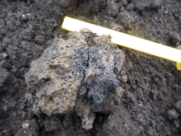 The golden pumice therefore means that the magma rose very quickly from deep beneath the volcano. This is consistent with the very intense eruption. Geochemists can measure how much gas is still dissolved in the rock, and how much is dissolved in material trapped inside crystals that formed at depth. From this, they can estimate the depth at which the magma was stored before the eruption, and how much gas (such as SO2) was released.
The southern crevasse field
Great volumes of ice near the crater was melted during the eruption. Since then, the glacier has flowed back toward the crater, producing a network of crevasses on the surface. Unlike crevasses in a more alpine setting, tephra has fallen into and filled these ones, allowing the area to be explored in relative safety. Unlike crevasses in a more alpine setting, these ones have steam coming out of them. Just a few centimetres down, the tephra pile here is still warm.
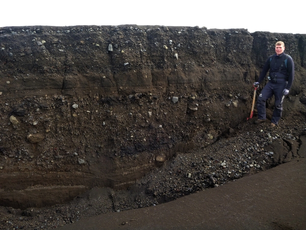
The long, tall walls produced by the crevasses are a volcanologists dream, as they expose all the individual layers produced by different stages of the eruption. These can be traced and measured over a wide area without the need for any digging whatsoever. Here, the deposit is rich in pale-grey, angular, dense rocky chunks, 10s of centimetres in diameter. These were cold pieces of old lava flows or other parts of the volcano that were ripped up and spat out during the eruption. They are heavy, and rained out from the plume close to the vent.
A view of the crater area
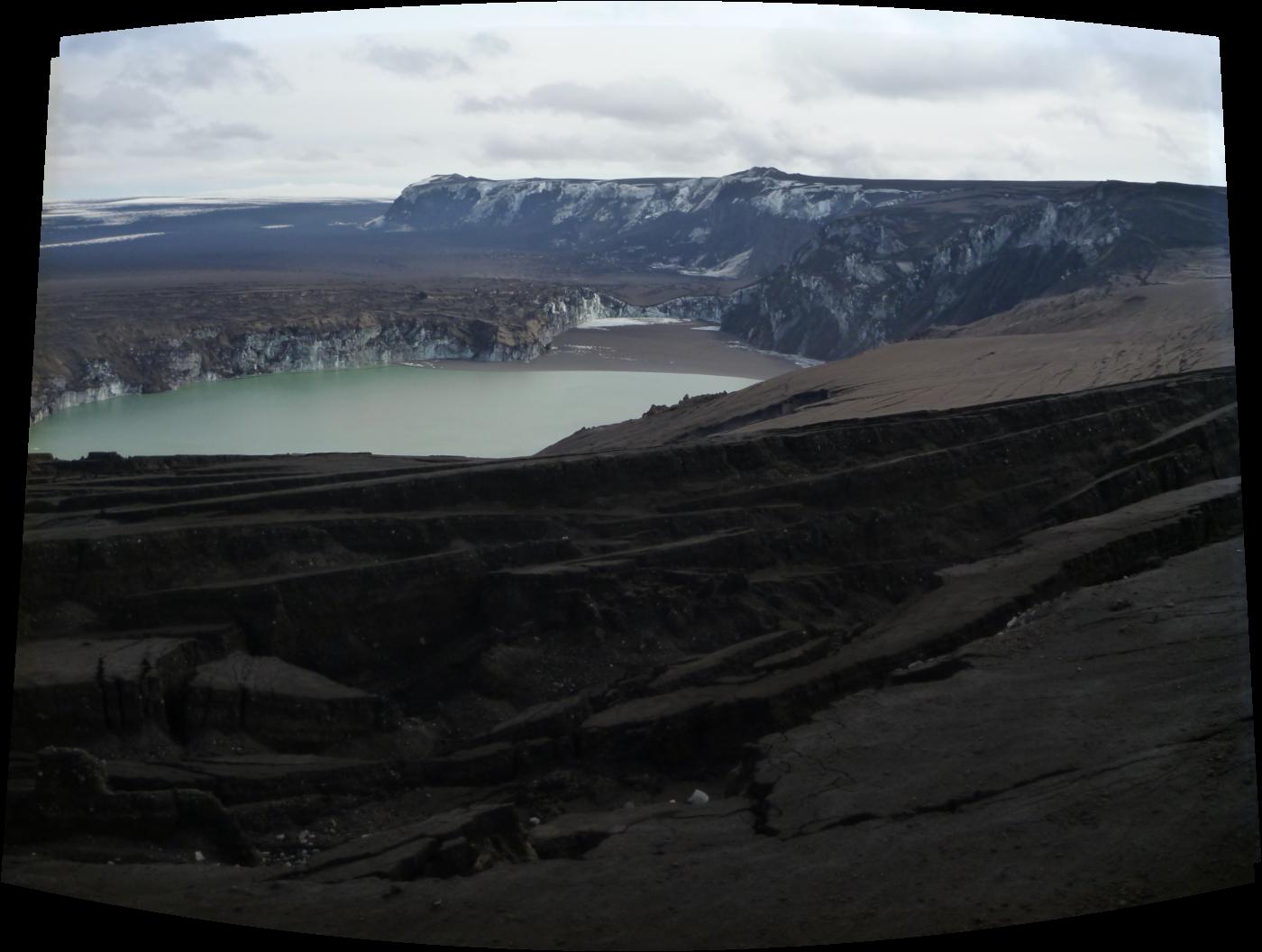
Looking across the crater area. Click for bigger version
The photo shows the crater area, looking from the west. The crevassed area in the foreground, with all the exposed tephra layers is clear. The ridge on the skyline is Mt Grímsfjall, and the huts are located at the far end. The cliff is about 200 m high. The eruption began along a 1.5 km fissure running parallel to the cliff, before focussing on a few craters.
The lower, flat, area of ice sits mainly on top of the permanent subglacial lake, Grímsvötn, which is kept from freezing by geothermal heat at the base. The water drains periodically from Grímsvötn in floods called jökulhlaups. The lake in the foreground has formed since the May 2011 eruption by surface water flowing in, and has flooded the site of the craters. The black area at the far end of the lake is not a beach, but a raft of floating pumice stones. The vertical ice cliffs are capped with tens of metres of tephra, and sometimes come crashing down into the lake.
It is a spectacular place.
The journey to Grímsvötn is described in the previous post (Grímsvötn 1 – Crossing the glacier) as well as the effect of the tephra on the glacier. The following post (Grímsvötn 3 – Bonus truck pictures) describes the difficulties of working on the tephra-covered glacier.


The ash-covered snow and ice could be what Saturn’s moon Iapetus looks like: http://solarsystem.nasa.gov/planets/profile.cfm?Object=Iapetus
-Tom Farr, JPL
Pingback: Grímsvötn 2011 (Part 2): Effects on aviation of the biggest Icelandic eruption since Katla 1918 | Volcan01010