Last month, the Institute of Earth Sciences of the University of Iceland and the Iceland Glaciological Society organised an expedition to Grímsvötn to study the deposits of the eruption that took place there in May. This post describes the journey to the volcano and the effect of volcanic ash and other debris from the eruption on ice and snow.
Driving on ice
Grímsvötn lies beneath the Vatnajökull ice cap, which is the largest glacier in Europe. At 120 km by 90 km by 900 m thick, it is huge. If, for some reason, you needed to hide the English Lake District, you could just slip it underneath. There would be room in there for the Yorkshire Dales, too. To get to the volcano it is necessary to drive across this expanse of ice, in our case approaching from the east.
Fortunately, driving on glaciers seems to be a relatively routine practice in Iceland. Two vehicles, equipped with winches, planks, shovels, compressors and a host of spares and tools can cross snow-covered ice with each providing a backup for the other. The other vital component is a set of massive, waist-high tyres.
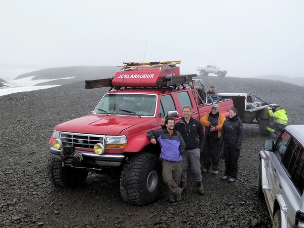 The final stage before driving onto the ice is reducing the air pressure in the tyres, which spreads the weight of the vehicle and greatly improves their grip. It may look like the truck is loaded with everything but the kitchen sink. That isn’t exactly true, but the large white object in the trailer is a household chest-freezer. This was brought to store samples containing ash-filled hailstones, which were produced during the eruption. At 08:00hrs, we were ready to get on the ice.
Follow the black ashy road
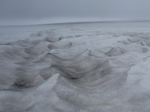
Ash from the Grímsvötn eruption is scattered thinly over the eastern part of the glacier. The dark coloured ash absorbs sunlight, heating the snow beneath and causing extra melting. Thus the surface of the snow, normally flat, is currently very uneven with curving ridges and smooth, wide valleys around 50 cm deep. In places they resemble frozen waves on a choppy sea. Crossing them is equally rough, and the maximum speed was around 10 km/hr.
 The eruption took place in the late spring, so there has been little new snow to bury the ash. Where it was blown into the tracks of vehicles that crossed the glacier back in June, it defines a vague road of long, dark, parallel trenches caused by the extra melting.
Snowfall accumulation and melting
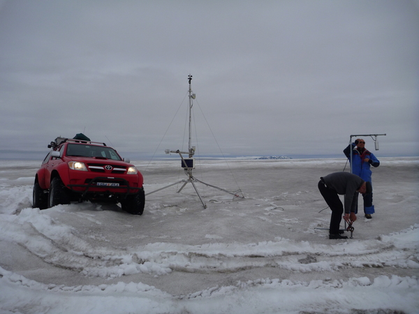
At a seemingly anonymous point, defined only by GPS coordinates, is a snow monitoring station. It uses echo-sounding the measure the distance from the sensor to the snow surface. In an average year, 6 m of snow fall onto the glacier in this area. Of those, 1.5 m melt and evaporate away; the remainder compacts and joins the rest of the ice flowing slowly to the lowlands. We stopped to adjust the height of the sensor and to download the data.
Thicker tephra and dirt cones
Tephra is the technical term for all the ash and pumice and rock fragments that are thrown out by an exploding volcano (strictly speaking, ash only refers to material less than 2 mm in diameter). Closer to Grímsvötn, the tephra got gradually thicker and coarser.
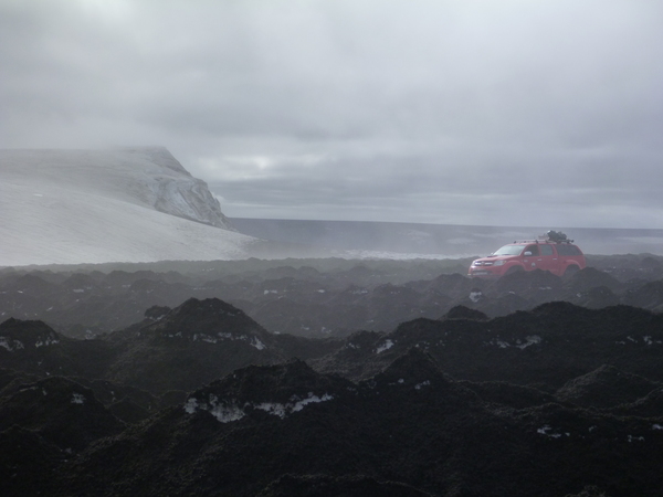
Once the tephra thickness gets more than a few centimetres, the effect that it has on the underlying snow changes. While the black tephra still absorbs extra sunlight, if the layer is thick enough then the heat isn’t transmitted through to the snow. Instead of enhancing melting, the underlying snow is protected. The result is a rough landscape of dirt cones. While the cones may be a metre high, the tephra only accounts for a black, sandy skin over their snowy cores.
Approaching the huts – Plan A
We were aiming for three wooden huts built on a ridge of rock called Grímsfjall, that pokes out above the ice. The normal approach is to drive up the slopes from the south, as the direct route from the east is blocked by a series of large crevasses. It appeared, however, that this route was also impassable. Where the tephra was even thicker (10-15 cm), it gave more uniform protection to the snow beneath, resulting the a series of large plateaux about 2 m taller than their melted-out surroundings.
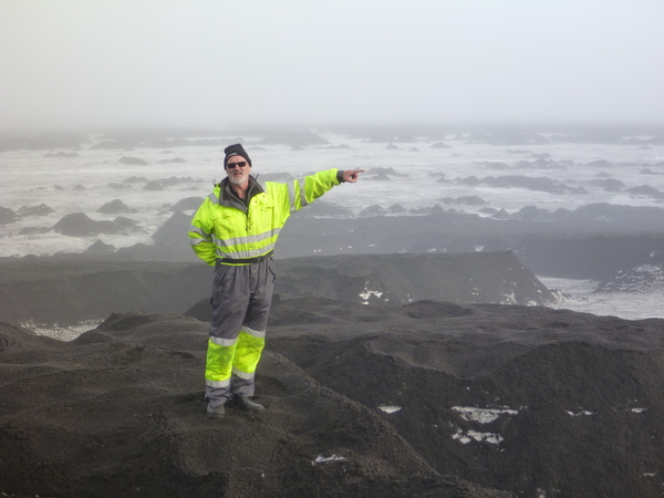 After driving back and forth along the foot of Grímsfjall and scanning the slope with binoculars, we could not see a way through. Potential leads were explored on foot, but they they were dead ends, finishing in steep dirty walls.
Approaching the huts – Plan B
It was decided that the best approach may be to try a bit further east, where the tephra was thinner. Driving up the slopes, things seemed promising as the black piles gave way to more open snow fields. We progressed steadily higher until CRUNCH! The front of the truck fell into a crevasse. These deep cracks form in the glacier where the ice accelerates down the slope and they are covered in snow-bridges that hide them from view. As the truck drove onto it, the bridge collapsed and it dropped down to its axle.
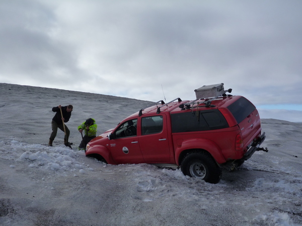 Removing the truck was suprisingly straightforward. Jump out, clear the snow from the front, set up a jack on the far side of the crack (which was only about a metre wide), jack up the truck, reverse out. It took less than 20 minutes. We looked for an area to the side where the crevasse was narrower then continued upwards.
CRUNCH! Another crevasse. We were going to need another plan.
Approaching the huts – Plan C
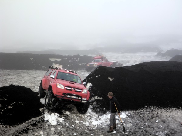
Where two high ash-covered platforms met, there was sometimes a notch in the wall. The notches were too narrow to drive through, but with a bit of shovelling, they could be enlarged sufficiently to allow the trucks and trailer to pass. A route was staked out on foot, then the gateways were dug through the snow. Four breaks were enough to give us access to the huts.
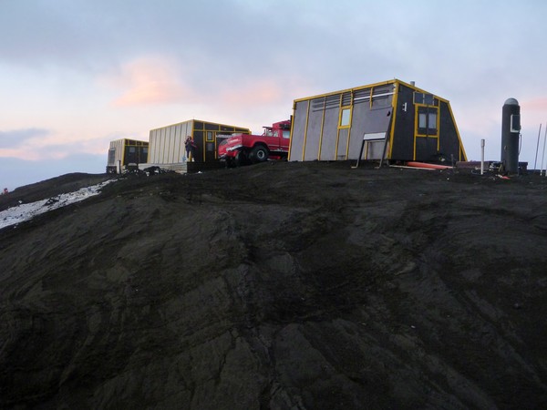
The Grímsfjall huts
Once through the worst of the tephra platforms, it was easy going to the crest of Grímsfjall and the huts. We finally arrived there at 20.30 hrs. With good snow conditions, the journey across the glacier can take just two hours. It had taken us over twelve. The difference was due to the tephra on the ice.
 Some observations from the fieldwork are described in the following post (Grímsvötn 2 – What was in the plume?) and there are some more vehicle-themed photos in another (Grímsvötn 3 – Bonus truck pictures).


I have just read Grímsvötn 1,2 and 3. Absolutely super reading with great pictures. I hope you get to go to places like that more often.
A big thank you from me.
Thanks, Rusty. Glad that you enjoyed it.
Very cool post, John. The journey to the Grimsfjall huts sounds like quite the adventure. Now I need to go read the other two posts. I missed this series when you put it up, because I was traveling. The UK rail system and motorways did feel like an adventure sometimes, but I think your journey exceeds that by at least an order of magnitude.
Thanks Anne, glad you liked it. At least on the glacier, as opposed to the UK motorway network, you know that you are travelling at walking speed for a reason…
Pingback: Grímsvötn 2011 (Part 2): Effects on aviation of the biggest Icelandic eruption since Katla 1918 | Volcan01010
Pingback: Grímsvötn 2011 (Part 1): UK ash deposition from the biggest Icelandic eruption since Katla 1918 | Volcan01010
Pingback: Fieldwork at the Holuhraun | Volcan01010