While international concern about an eruption at Bárðarbunga is focussed on flight disruption, a jökulhlaup (meltwater flood) is the most destructive potential outcome of a subglacial eruption. It would travel north from the glacier along the Jökulsá á Fjöllum river, and for this reason roads have been closed in the area. Edwin Baynes is a PhD student at Edinburgh University who studies past jökulhlaups in this area. In this guest post, he puts such a potential flood in context.
Turning Dettifoss into Niagara Falls
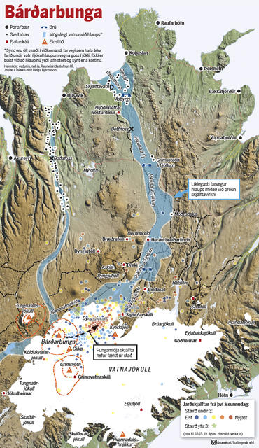
An Icelandic geophysicist, Magnús Tumi Guðmundsson, has predicted that if a subglacial eruption were to occur at Bárðarbunga, the meltwaters could increase the discharge in the Jökulsá á Fjöllum river by 10 or 20 times (to 2,000 – 4,000 m3 s-1). He describes such a flood as ‘not catastrophic‘ because it is smaller than the jökulhlaups caused by the 1996 Gjálp eruption (45,000 m3 s-1), which washed away the Skeiðarásandur bridge in South Iceland, or the estimated discharge for the Katla 1918 flood (300,000 m3 s-1). It is still very serious, however, and has potential to inundate the landscape and destroy important infrastructure such as bridges and farms. The map below shows the areas most likely to be affected.

Area most likely to be affected by jökulhlaup following subglacial eruption at Bárðarbunga. Published by Morgunblaðið – click image to see original article.
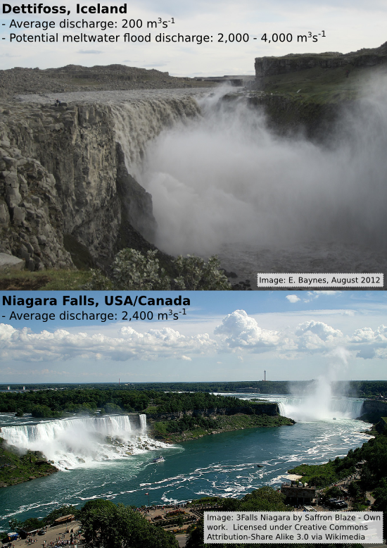
Jökulsá a Fjöllum contains some pretty impressive waterfalls, the most notable of which is Dettifoss. With a vertical drop of around 50 m and a peak summer discharge of 300-400 m3s-1, it is reputed to be ‘Europe’s most powerful waterfall’. Sci-fi fans may recognise it from the start of Prometheus, much of which was filmed in Iceland.
For comparison, the average discharge of the Niagara river is ~2,400 m3s-1 at Niagara Falls. Although Niagara Falls and Dettifoss have similar vertical drops (~50 m), Dettifoss is much narrower (~100 m wide vs ~700 m). A 20 times increase in discharge would mean a significant rise in water level within the channel, increased erosion and a possibly even an upstream retreat of Dettifoss waterfall by a short distance.

A jökulhlaup down the Jökulsá á Fjöllum river following a subglacial eruption at Bárðarbunga could increase the discharge over Dettifoss to levels similar to Niagara Falls.
Evidence for past jökulhlaups
Although rare on a human timescale, the Jökulsá á Fjöllum is no stranger to jökulhlaups. There are historic reports of powerful floods in the 17th and 18th centuries that destroyed farmland further downstream from Dettifoss. There have also been numerous prehistoric jökulhlaups of varying magnitude over the last 10,000 years, since most of the ice retreated from Iceland. Alho et al. (2005) used computer models to estimate the discharge that would be necessary to produce the water levels indicated by the highest boulder deposits and the highest fluvially-washed surfaces along the channel. Their result was 900,000 m3s-1. This is more than triple the flow of the Amazon and close to rivalling some of the biggest ‘megafloods’ that have ever occurred on Earth.
As expected, such large discharges had a significant impact on the landscape. The evidence for this erosion by the Jökulsá á Fjöllum river is preserved in the rocks of the Jökulsárgljúfur and Ásbyrgi canyons.

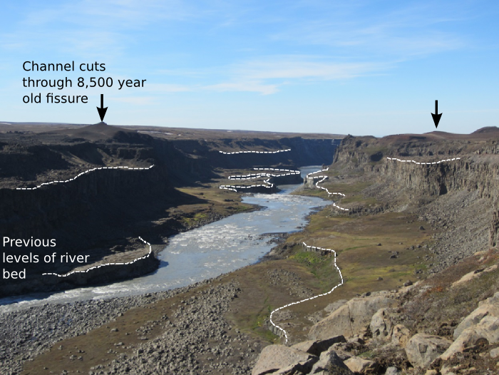
Looking downstream from Dettifoss into the ~500 m wide, 100m deep, Jökulsárgljúfur canyon, carved out by jökulhlaups since the last Ice Age. Photo: E. Baynes, June 2012
The canyon is significantly wider than the modern river channel (~100 m wide), indicating that the flow was much greater when the canyon was formed. Within the canyon are strath terraces (white dashed lines) that indicate historical positions of the river bed. The upper terrace is at the same elevation as Dettifoss and has been abandoned due to the retreat of Dettifoss during the largest jökulhlaups. Also shown in the photo is a volcanic fissure that erupted 8500 years ago. The canyon has eroded through one of the volcanic craters, exposing the conduit that brings lava to the surface in the canyon walls. The canyon is therefore younger than the fissure (i.e. <8,500 years).
The product of a catastrophic jökulhlaup

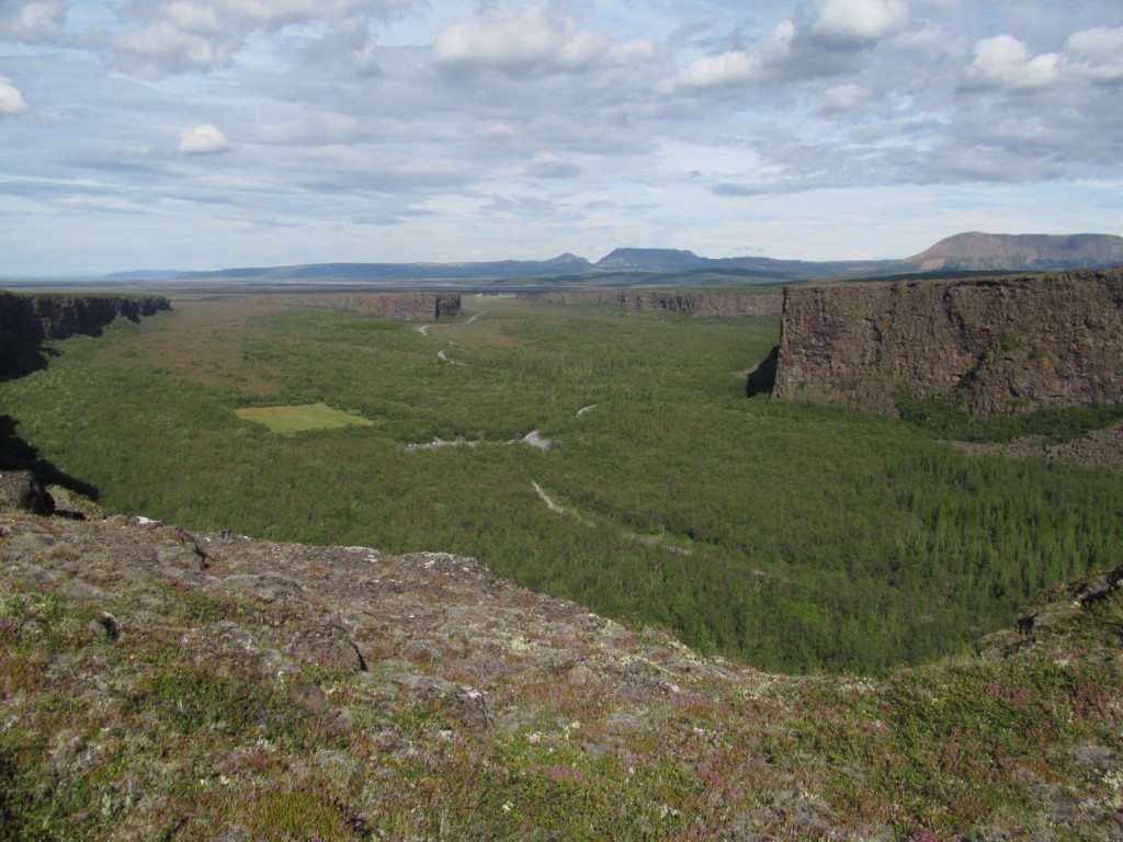
Caption: Looking North into Ásbyrgi canyon. Horseshoe shaped, 3 km long, 1 km wide, up to 100 m deep was carved out during a jökulhlaup that flowed away from where the photo is taken from. The floor of Ásbyrgi is littered with large boulders (some greater than 3 m in diameter) which shows that once there was a high magnitude flow within Ásbyrgi capable of transporting such large blocks. Photo: M. Attal, August 2012
Twenty-five kilometres north of Dettifoss is Ásbyrgi, a vast horseshoe-shaped canyon 3 km long, 1 km wide and up to 100 m deep. According to Norse mythology, Ásbyrgi was formed when Odin’s 8-legged horse, Sleipnir, stumbled and put a hoof down on Earth. However, evidence in the landscape suggests that a more likely hypothesis is that Ásbyrgi was carved during a jökulhlaup along the course of the Jökulsá á Fjöllum.

The large plunge pool at the base of the headwall at Ásbyrgi. Upstream, the landscape has been heavily scoured and sculpted by the action of water. Photo: M. Attal, August 2012
Large plunge pools are present at the base of the canyon headwall, there is a water-sculpted surface immediately upstream of the canyon and the amphitheatre-shaped canyon head is very similar to features elsewhere such as Box Canyon in Idaho and Dry Falls Lake in Washington. Both of these formed during floods following catastrophic drainage of ice-dammed lakes Bonneville and Missoula, respectively. Each of these features indicate a jökulhlaup origin for Ásbyrgi and show the potential for catastrophic erosion during jökulhlaups along the Jökulsá á Fjöllum following volcanic eruptions beneath the Vatnajökull ice cap.
Edwin’s PhD project is titled: Constraining bedrock erosion during extreme flood events in Iceland. He researches jökulhlaups in the Jökulsárgljúfur and Ásbyrgi canyons using topographic analysis and surface exposure dating with cosmogenic nuclides. You can find more information on his website at http://www.geos.ed.ac.uk/homes/s1141604/. You can also follow Edwin on Twitter: @EdwinBaynes.


Pingback: Icelandic Earthquake Swarm Heads Towards Askja: What Could Happen? | Science Blogs | Tsangg
Pingback: The photos from Iceland’s latest volcanic eruption are spectacular | ???? ??????
Pingback: Photos from Iceland's latest volcanic eruption - Vox
Pingback: ???? ?? ???? ?? - ????? ????
Pingback: ???? ?? ???? ?? - ????? ????
Pingback: Iceland’s erupting volcano looks absolutely stunning from space | ???? ??????
Pingback: Iceland's erupting volcano looks absolutely stunning from space | c7c World
Pingback: Four years of volcan01010: Highlights of 2014 | Volcan01010