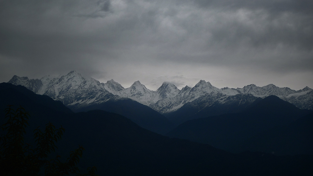
Eclogite: mysterious visitor from the deep

This post was chosen as an Editor's Selection for ResearchBlogging.orgFifty kilometres is not far. World-class marathon runners run 42km in a little over 2 hours. They only move along the earth’s surface though. Getting to 50 kilometres below your feet is a different thing entirely. It’s a  place of crushing pressure and meltingly high temperatures, somewhere human beings will never go. There is a type of rock that’s been there – and deeper – and yet somehow returned to tell the tale. On this journey its been transformed multiple times, released fluids that cause new crust to be generated far above, even grown diamonds. Its also the most attractive rock type of all. It’s called eclogite and its gorgeous.
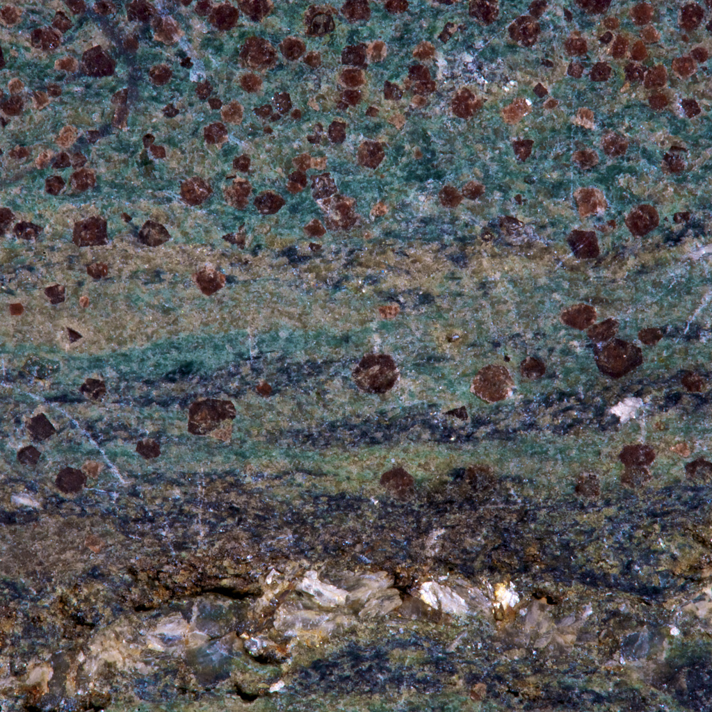
This is from the lawsonite type locality, Reed Station on the Tiburon Peninsula, Marin County, California. Keele collection.

This is from the lawsonite type locality, Reed Station on the Tiburon Peninsula, Marin County, California. Keele collection. From @hypocentre on Flickr http://www.flickr.com/photos/hypocentre/4639062593/in/photostream/

The beautiful red mineral is garnet, the lovely green is omphacite, the exquisite blue glaucophane.

Eclogite is rock of mafic composition (igneous rock relatively low in silica) that has been buried to 50 kilometres or more. At this depth, everyday minerals such as plagioclase feldspar or augite are no longer stable and they break down, allowing the rock to grow new denser (more attractive) minerals that are better suited to higher pressures.

Eclogites are typically formed by subduction of oceanic crust. Oceanic crust forms at mid-ocean ridges, where melting of the earth’s mantle produces a layered crust of mafic composition, basalts on top, gabbro below. New areas of oceanic crust are constantly being created and, to balance, older colder oceanic crust is pushed back down into the mantle at subduction zones. As the crust is pushed deeper and deeper, the gabbro and basalt is transformed into eclogite.
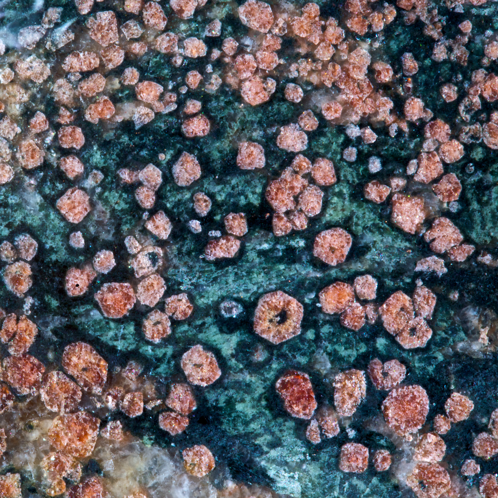
http://www.flickr.com/photos/17907935@N00/4652324838

Another picture from Ian Stimpson. Sample from the Mariánské Lázně Complex in the west Czech Republic. Keele Collection. http://www.flickr.com/photos/17907935@N00/4652324838

Pieces of eclogite that we can study and admire have somehow been brought back to the surface. How does this happen? Does subduction go into reverse, or does it get back to the surface in some other way? I’ll save these questions for another post.

Most eclogite doesn’t reach the surface, but returns to the mantle for good. Eclogite is denser than the surrounding mantle rocks and some subducted plates reach the very bottom of the mantle nearly 3000 kilometres below our feet. Material that’s been on this journey started as humble basalt but has been through a whole range of transformations, into eclogite and beyond.

For this post, I want to stick with a paper that illustrates how eclogites provide direct evidence of processes that we could only otherwise study indirectly.

Deep earthquakes, those below about 70km depth, are a little mysterious. At those depths, rocks are so hot they flow rather than fracture and so squeezed that fractures shouldn’t be able to move. Deep earthquakes are only seen in subducting slabs of oceanic crust. There’s been much speculation about the possible mechanisms that allow deep earthquakes. This is mostly based on seismic evidence and our knowledge about the transformations that occur in these rocks as they are buried. Wouldn’t it be great to somehow get hold of actual rocks from one of these deep fault zones?

Tucked away in the Italian Alps the Monviso Ophiolite is a crustal slice of an extinct ocean called Tethys. As if moving from ocean basin to high in the Alps wasn’t enough, it’s also been buried 80 kilometres under the surface. As described by Samuel Angiboust and colleagues in this months Geology, it contains not just eclogites, but eclogite breccias, something never found before. These are not sedimentary breccias – the material between the angular blocks is not sand or mud but consists of eclogite facies minerals. The eclogite was fractured at great depth. Even individual grains of garnet show evidence of multiple episodes of fracturing. There is a lot of deformation going on, there is a mylonitic fabric, a result of ductile deformation (flow rather than fractures), active both before and after the fracturing.
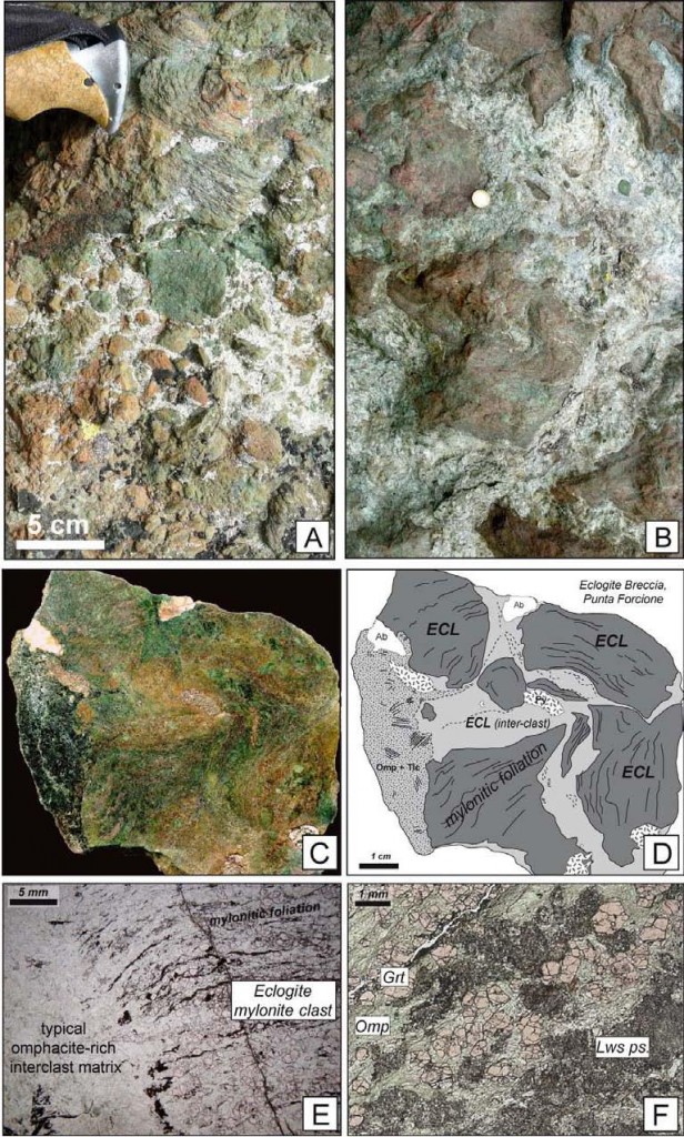
Typical textures from eclogite breccias described by Angiboust et al. Figure DR-1 from DATA REPOSITORY/ G32925 (URL in text). Follow this link for more description.

Using multiple lines of evidence, our authors suggest that the breccia was formed in a fault zone that created Magnitude 4 earthquakes at between 70 and 80 km depth. The minerals in the breccia suggest fluids were present and may in some way have allowed the fracturing to occur. The other forms of deformation (mylonites and fractured minerals) were relatively dry, but also silent and not directly detectable from the surface.

Eclogites are like mysterious and beautiful emissaries from another world. You can learn a lot about a place remotely, by listening to its earthquakes and so on, but finding something that’s been there and can tell you about it – that’s really special.

References

S. Angiboust, P. Agard, P. Yamato, & H. Raimbourg (2012). Eclogite breccias in a subducted ophiolite: A record of intermediate-depth earthquakes? Geology DOI: 10.1130/G32925.1

Supplementary material found at  DATA REPOSITORY/ G32925 (downloadable PDF).


How old is plate tectonics?

Plate tectonics is the process that underpins much of our understanding of the Earth. It explains manymany aspects of the Earth, from magnetic patterns in oceanic rocks to the distribution of plants and animals. How unusual is it? Well, it doesn’t seen to be happening on other rocky planets in our solar system. Many geologists have argued that plate tectonics wasn’t active during the earth’s early history. As astronomers find many rocky planets in other solar systems, the question of understanding how ‘typical’ plate tectonics has implications beyond the earth. How long has it been going on – how old is it?

The Precambrian, is the span of earth’s history before the Cambrian. When geological periods were first defined, by largely-British geologists in the Nineteenth century, they were distinguished by the fossils they contained. Precambrian fossils are rare (hard shells only evolved in the Cambrian) and not until the Twentieth century could we calculate the absolute age of rocks. Precambrian rocks in Britain are fairly uncommon, mostly restricted to the Highlands of Scotland, so lumping them into one group made sense at the time.

Geological timescale clock from Wikipedia

Unfortunately, it turns out that the Precambrian covers the vast majority of earth’s history. Now that we can get an absolute age for many rocks, it’s possible to divide the Precambrian into smaller chunks. The next level of division consists of the (increasingly old) Proterozoic (“earlier life”), Archaean (“beginning”) and Hadean (“hellish”).

Precambrian rocks are often very different to modern ones. As well as the atmosphere being very different, the earth itself was hotter (younger radioactive isotopes give off more heat). Rocks like komatiite lavas which erupted at 1600 °C, far hotter than modern basaltic lava, suggest that mantle temperatures were then much higher. For this and other reasons, its often been assumed that plate tectonics was not active in earth’s early history.

A paper by Peter Cawood and two other Oz-based scientists called “Precambrian plate tectonics: criteria and evidence” (free!) addresses this question in a systematic way.  First they contrast plate tectonics and ‘plume tectonics’ as two different ways of transferring heat out of the earth. Both are active now (e.g. Hawaiian plume is a hotspot) but plate tectonics is dominant.

How to distinguish the two? One key difference, Cawood argues, is that plate tectonics involves “the differential horizontal motion of plates”. Plate tectonics is all about chunks of crust wandering about the place, so evidence of this is significant. How to track the ancient movements of the plates? Palaeomagnetology, or palaeomagic as it is jokingly referred to, is the study of earth’s ancient magnetic field. As magnetic minerals form, or cool down, they fix an impression of earth’s magnetic field within them. Heating samples in the lab allows us to measure the orientation of this fossil magnetic field or ‘palaeopole’. One way in which these palaeopoles can be useful is to tell you the latitude of the sample at that time. Plotting palaeopoles from different areas of Precambrian rocks at different times, Cawood demonstrate that they change latitude over time, both absolutely and relative to each other. If continents are drifting, then plate tectonics is responsible.

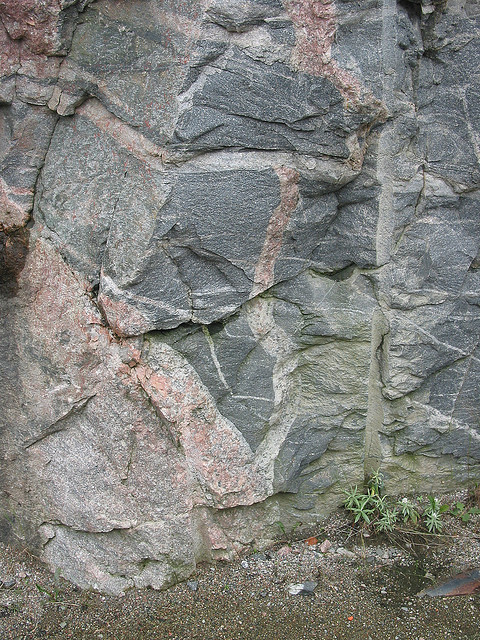
Greenstone Xenoliths in Archean Gneiss, near Sand River, Ontario

Greenstone Xenoliths in Archean Gneiss, near Sand River, Ontario, by Ron Schott: http://www.flickr.com/photos/rschott/303768298/sizes/z/in/pool-517016@N23/

Archean rocks often consist of distinctive granite-greenstone terranes that are not linked obviously to plate tectonic processes. Cawood lists evidence that while it may not be obvious, the link is there – in particular distinctive features such as ophiolites (slices of sea-floor on continents) and eclogites (very deeply buried metamorphic rocks) are increasingly being identified in very old rocks. Evidence from geochemistry and metal deposits is also brought to bare to argue that plate tectonics was active for most of the Precambrian and may have been active from the dawn of earth’s history. Precambrian rocks are distinctive, but the fundamental mechanism that drives the modern earth affected them too.

This paper is a great summary, but is not the final word (of course). Other scientists argue that plate tectonics wasn’t active and other processes were dominant. For example one groupuse numerical modelling and emphasise the importance of mantle temperature. If the mantle is too hot, then the lithosphere is weakened by melt and so not rigid enough to move as plate. An intermediate stage towards modern plate tectonics involves shallow underthrusting of oceanic lithosphere under continents. A very recent paper involving physical modelling of Archean crust provides an overview of alternative views. The paper focuses on explaining features of Granite-greenstone terranes such as “dome and keel” geometry in terms of channel flow. Channel flow is where soft squishy crust starts flowing sideways under pressure; today it happens (perhaps) only in thickened crust in mountain belts, like the Himalayas. In the hot Archean, it could have been a much more common process.

Whether or not the fundamental processes are the same, the Archean earth was very different to the planet we are sitting on now. It was frequently struck by large lumps of space debris, had a radically different atmosphere, no ‘visible’ life and weird geology. If we were suddenly transported to the Archean, we might (in the few moments before we suffocated) think we were on a different planet. When studying the remains of such a place, the uniformitarian idea that “the present is the key to the past” is stretched to breaking point. Understanding these extremely ancient rocks is very hard indeed, but it is one of the most interesting challenges in geology.

References

Cawood, P.A., Kröner, A., & Pisarevsky, S (2006). Precambrian plate tectonics: criteria
and evidence GSA Today DOI: 10.1130/GSAT01607.1

Open access link.

L.B. Harris et al. Regional shortening followed by channel flow induced collapse: A new mechanism for “dome and keel” geometries in Neoarchaean granite-greenstone terrains Precambrian Research 212-213 (2012) 139–154  Open access link.

Sizova et al., (2010) Subduction styles in the Precambrian: Insight from numerical experiments Lithos 116, 3-4  dx.doi.org/10.1016/j.lithos.2009.05.028Open access link.


The Geology of Mount Everest

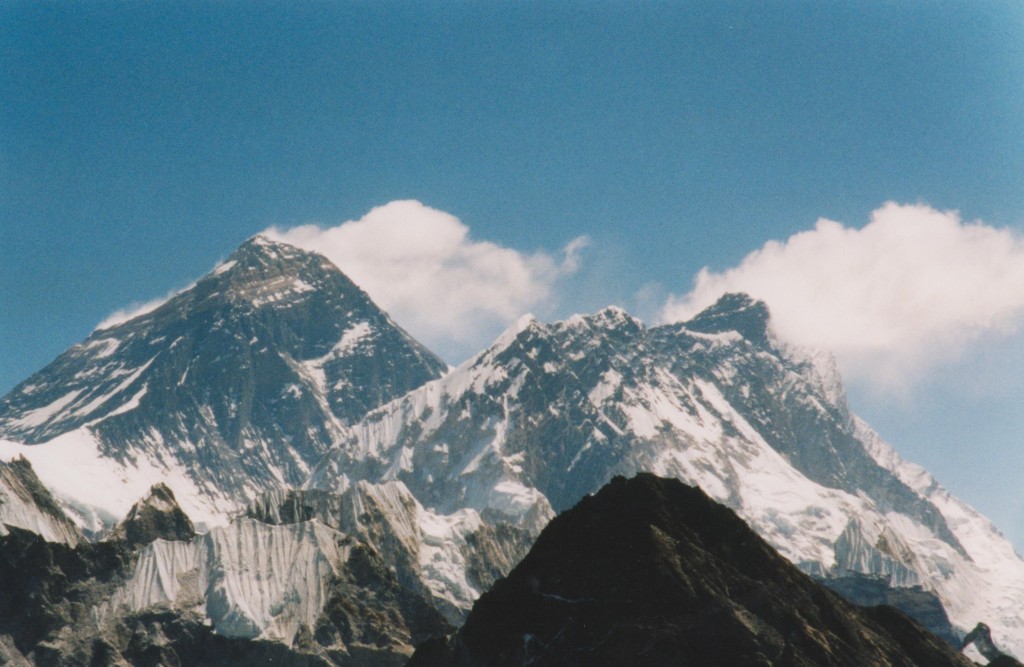
This post was chosen as an Editor's Selection for ResearchBlogging.orgGrowing up, I was mildly obsessed with Mount Everest. Even now I marvel at its wonderful geology.

Looking at that, who can blame me?

My youthful obsession was fuelled by books of British expeditions in the 1970s climbing it by various routes with varying levels of success.  The photos were the best; an image by Doug Scott showing Everest, Lhotse and Makalu, taken by from Kangchenjunga was particularly mesmerising. <aside> Makalu (left-hand of 3 tall peaks) in particular is intriguing as it looks like it had a glacial ‘U-shaped’ valley that has now mostly fallen away in landslides. If you know more, please tell me! </aside>.  I started my teenage years wanting to climb mountains like this, but by the end of my teens this had waned. It was too apparent that many people in the early books had been killed on the mountains. Now that Everest seems full to the seams with the rich and the foolish – littered with their corpses – the glamour has worn off somewhat.

It was still a great thrill to go on a walking holiday to the Everest region, particularly as by then the geology of the area was properly understood. I shall use my pictures to illustrate the geology, as described in a 2003 paper by Mike Searle and colleagues, available on line via his Everest map website.

Let’s revisit that first picture.

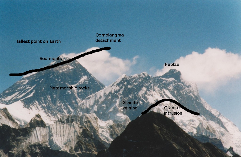
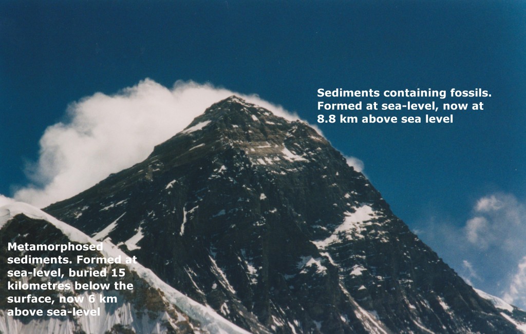
Mount everest geology

This shows the main features, north is to the left. The summit area is made of sedimentary rocks, now far from the sea. The contact with the metamorphic rocks is not an unconformity, but an extensional detachment:  a structure – here brittle fault, there shear zone- that is usually associated with thinning of the crust. The Qomolongma detachment, together with the Lhotse detachment (in my picture, hidden in the Western Cwm, the valley between Everest and Nuptse) together are part of the South Tibetan Detachment System (STDS) which can be traced along the entire Himalayan chain

The rocks labelled as metamorphic rocks are greenschist facies, but the Nuptse ridge (right hand side of picture) contains high-grade sillimanite gneisses and many granite intrusions. These are part of a package of high-grade metamorphic rocks, the High Himalaya Crystalline series that are everywhere found below the STDS. Searle and colleagues explain these rocks in terms of channel flow.  This amazing theory says that between 21 and 16 million years ago, a thick channel of soft hot rocks flowed out from under the Tibetan Plateau towards the Himalayas.

The Qomolangma detachment is part of the top of this channel. The high-grade rocks below flowed 200km south into their current position, moving at a shallow angle parallel to the top of the channel.  The driving force for all of this? The snow and rain falling on the mountains and eroding the surface.

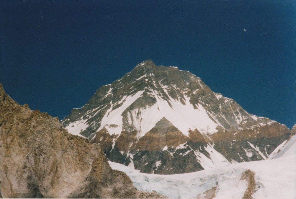
Let’s look at the rocks in more detail. Above is a picture of Changtse in Tibet, taken from near the head of the Khumbu valley in Nepal. It is looking up and north at the Qomolangma detachment. The prominent yellow band, often mentioned by mountaineers, is marble and lies just below the detachment. Above are unmetamorphosed sediments. Left in the foreground is mostly granite.

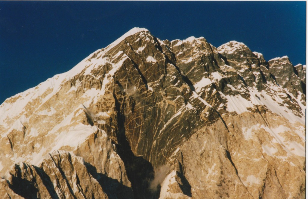
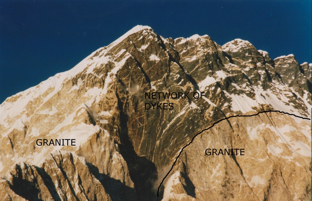
Turning to the metamorphic ‘channel’ rocks lets look at the South face of Nuptse, from a more direct angle.

The picture is around 3 kilometres from top to bottom. The dark rocks are high-grade gneisses, that flowed 200km towards the camera. A clue as to how they did that is found in the pale areas – granite. Rocks containing melt have a much lower viscosity. The many dykes/veins in above the granite are, according to Searle, an “explosive network of dykes emanating out of the top of the Nuptse–Everest leucogranite” caused by late-stage volatile rich magma. In other words, the fluid left behind as the main intrusion cooled and solidified.

Nuptse south face geology annotated

Searle interpret the right-hand granite body as a sill that ballooned into a much thicker body. It passes under the summit of Everest and an equivalent body is found in the east Kangshung face of Everest. They speculate that the presence of this 3km thick granite body might explain the particularly high mountains.

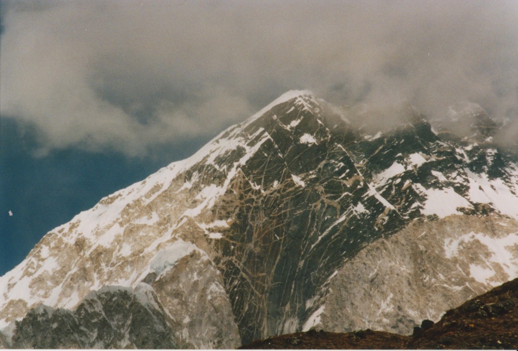
Another view there, in different light with some moody clouds.

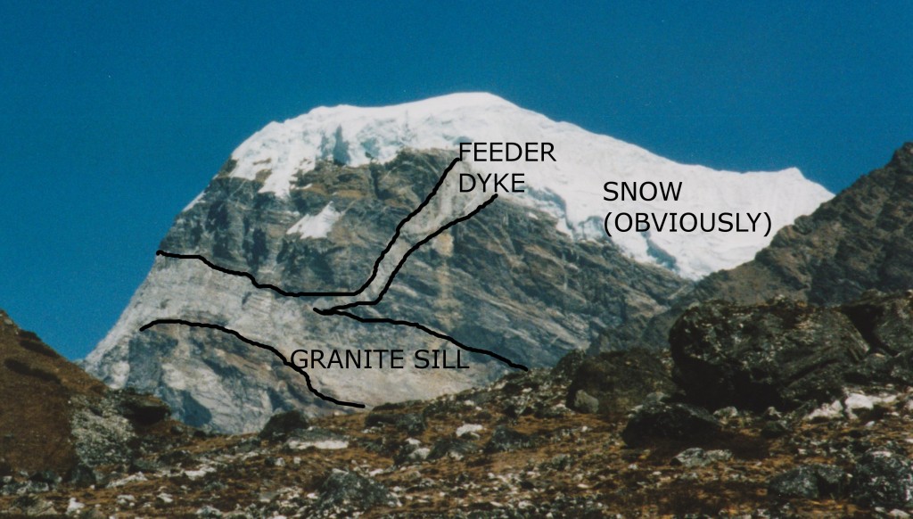
Granitic sill and feeder dyke, khumbu valley

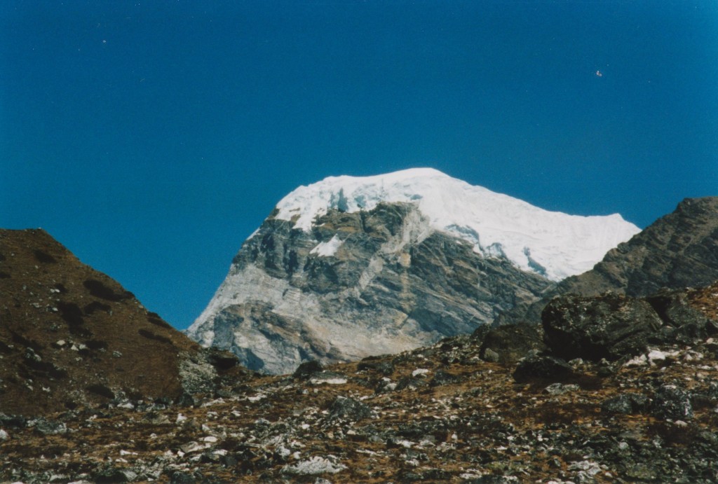
This is a view of an unnamed mountain on the side of the Khumbu valley. It shows a more typical view of the granite intrusions in the area, plus a glimpse of how it was intruded.

Annotated granite dyke-sill Everest region

Granite sills are typical of the area, but the dyke was the only one I saw. The intrusion process was of sills making space via hydraulic fracturing along bedding/foliation planes in the dark metamorphic rock. Dykes allow flow between sills.

In the 30’s and 50’s mountaineers on Everest were also explorers and they collected samples  One  geologist, Lawrence Wager, got to with 300m of the summit in 1933 and later became Professor of Geology at Oxford (my alma mater) . One paper on Everest geology (Jessup et al 2006) is a detailed study of microstructures. It involved studying Wager’s samples, plus others collected on the 1953 expedition. One was collected by Edmund Hilary only 12 metres below the (snow-covered) summit. Either just before or just after he became the first man on the Earth’s highest point, he took the time to collect a rock sample. Mount Everest and geology are closely intertwined.

References and further reading

ResearchBlogging.org
SEARLE, M., SIMPSON, R., LAW, R., PARRISH, R., & WATERS, D. (2003). The structural geometry, metamorphic and magmatic evolution of the Everest massif, High Himalaya of Nepal-South Tibet Journal of the Geological Society, 160 (3), 345-366 DOI: 10.1144/0016-764902-126

The Searle paper came out of joint research between Oxford and Virginia Tech universities. Both have websites with more gorgeous pictures. The Oxford one has a low-res version of a map made of the area and includes a copy of the Searle paper. The Virginia Tech one has pictures linked to a map.

Ron Schott has compiled a list of Gigapans from the Himalayas, including a few from the Everest region.

You can find more on the Wager / Everest connection online. If you want to see a photomicrograph of the highest rock sample ever collected, figure 6 of the Jessup et al paper is the place to go.

This post is the summit of my journey into the Geology of mountains. If you want more detail on channel flow and associated concepts, that’s the place to go.

Channel flow – hot rocks, big glaciers and the world’s tallest mountains

Leonardo da Vinci, famed artist and Renaissance “Renaissance Man” made some interesting remarks about Geology. When he looked at rocks in the Alps containing fossil molluscs, it was clear to his trained eye that the fossils were near identical to shells formed by creatures in the sea. That fossils are the remains of ancient creatures seems obvious now, but was a controversial idea at the time. This makes it even more impressive that he made the further step of thinking about how things that formed in the sea ended up on the top of mountains.

We now know that the highest peaks in the world – such as Mount Everest – are formed from ancient marine sediments. When we think about a coral – that grew safe and snug in a warm ocean that no longer exists – now lifted up 9 km to form the top of Mount Everest, the only proper response is awe. The rocks just below are even more amazing. They started in the sea  but they’ve been buried 15 kilometres below the surface, partly melted  and then drawn up to the surface by snow and rain.

everest geology

Channel flow

If you bury the right sort of rocks in the right sort of way, they form a hot soft layer in the middle of the crust. In Asia, a soft layer is formed by the collision between the Indian and Asian plates stuff sediments (rich in heat-forming radioactive elements) down under the Tibetan Plateau. Stuck between a cold rigid layer (the upper crust) and a strong rigid layer (lithospheric mantle) this soft layer is like jelly (jam) in a  sandwich. In special places on either end of the Himalayas, this ‘jam’ squeezes to the surface via a process of extrusion in a ‘tectonic aneurysm’. Extrusion is a particular case where the middle crust ‘jam’ reaches the surface, the more general concept is called channel flow.

The idea of channel flow was born on the INDEPTH geophysical surveys of the Tibetan plateau, led by Doug Nelson. These suggested that there is molten rock beneath Tibet right now. At the same time, geologists across the the Himalayas were puzzling over a thick layer of metamorphic and igneous rocks (High Himalayan Crystalline Series, below) that looked as if it had been squeezed out from underneath Tibet. Channel flow puts these the two observations together – hot rocks generated beneath Tibet flowed, lubricated by molten granite, out into the high Himalaya.

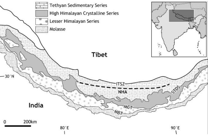
tectonic map of Himalaya from Harris (2007)

In 2004, there was a conference hosted by the Geological Society of London on the subject. This brought a fantastic range of techniques to bear on the problem – geophysics, mathematical modelling and a wide range of geological studies. The ‘special publication’ based on this conference is a fantastic resource; it mixes maths-rich papers – modelling the patterns of flow that are possible, with papers full of pictures of rocks – inferring how they flowed in the past.

It’s a big thick book, but in a sentence it goes as follows. “Hot rocks in the middle crust of Tibet have formed a weak ‘channel’ that flows laterally out from areas of over-thickened crust (probably, but more research etc…)”. There are two main ways this lateral flow of ‘the jam’ can happen.

Something moving deep inside

Imagine you are standing in eastern China looking west at the Tibetan mountains – what does the future hold? Channel flow predicts that hot middle crustal rocks are flowing into the crust below your feet. Deep below, a continuous slow shuffling of atoms in lattices is changing the shape of mineral grains. With enough time, small things make big changes and solid rock can creep and flow and squeeze itself along. The ground you are standing on is ever so slowing being jacked up.  In time it will be several kilometres  higher and part of a wider Tibetan Plateau. The pandas will be gone, replaced by yaks.

This process would take millions of years longer than a human lifespan, or course and there is little solid evidence it will happen in the future. It almost certainly happened in the past though – there is evidence from river gorges in eastern Tibetan of 1.5km uplift in the last 5 million years. Channel flow is a convincing mechanism to explain how this happened.

Hot rocks, big glaciers and the world’s tallest mountain

It is quite hard to know what is going on 20km below your feet. Places where the channel reaches the surface are easier to understand as you can do Geology at the surface, studying the cooled channel rocks  (the ‘fossil jam’). A 2007 JGS review paper by Nigel Harris of Britain’s Open University (available free online) looks in particular at the rocks found on the southern edge of the Tibetan plateau – the Himalayas.

One of the key observations leading to the proposal of channel flow was the observation that metamorphic rocks of the High Himalayan Crystalline Series – “HHCS” are bounded between two fault systems. Underneath there are thrust faults, above there are extensional faults, notably the South Tibetan Detachment System – “STDS” (not STDs, oh no). The combined sense of movement of these faults is to push the metamorphic rocks out. These metamorphic rocks acted in the past as a hot flowing channel, moving from under Tibet out and along to form the world’s tallest mountains.

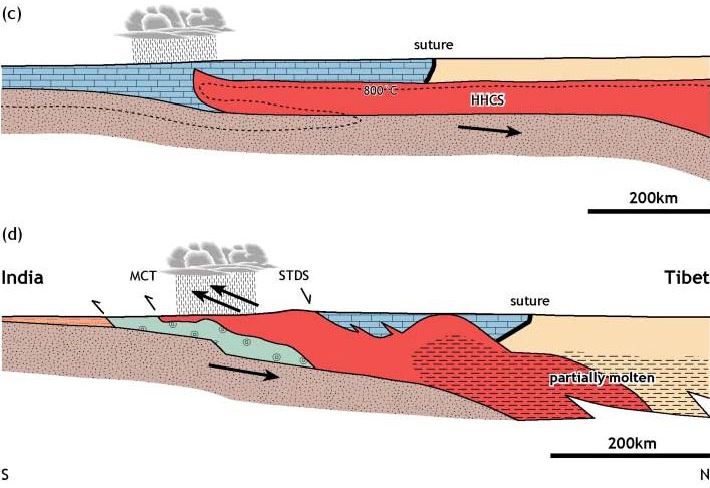
Channel flow cross section from Harris (2007)

This cross-section shows the channel flow model. Underneath the Tibetan Plateau, a hot (red) channel of soft rocks forms in the middle crust (the scale is very large so the topography is not very apparent). The stippled grey/brown material is the Indian Crust moving underneath. The Tibetan Plateau heats up in Spring and pulls moist air off the Indian Ocean up north over the Indian sub-continent to form the monsoon. Little of it gets beyond the southern edge of the plateau (cloud in the diagram) as the mountains cause precipitation. The enhanced erosion, from rain, rivers and glaciers causes exhumation (like at Nanga Parbat) and starts to draw the channel to the surface.  The lower diagram shows a slightly later stage, showing specific tectonic features. Enhanced erosion on the Himalaya front initiates a flow of material that reaches deep into the crust and 100s km laterally under the Tibetan Plateau.

This is such a beautiful idea that it ought to be true. But is it?

After extensively reviewing other models and all available evidence, Harris makes some interesting conclusions. First, “There can be little doubt that the high-grade rocks of the Himalaya were extruded southward, bounded by thrusting below and normal faults and shear zones below” so the metamorphic rocks were squeezed out as a package. Further, “evidence is emerging that is largely consistent with the hypothesis that southward extrusion during the Early to Mid-Miocene was facilitated by channel flow”, so it has happened, if only for a while 20-15 million years ago.

There is much less evidence that channel flow  in the Himalayas has been happening since. Current day zones of high exhumation and high rainfall are found further south where they are associated with brittle thrusting in lower grade rocks. This can be explained by viscous wedge models rather than by channel flow.

Himalayan rain from nandadevieast on Flickr

Rain and snow is amazing stuff. For a period of time it was able to influence rocks deep under the surface and 100s kms away, enticing metamorphic rocks to flow towards the surface where they can be broken into pieces and washed away back to the sea. The precipitation patterns are controlled by topography which is controlled by tectonics which is influenced by precipitation patterns… We make stories about the world, as that is the way our minds work, but a world where everything is so deeply connected can’t be reduced to our simple linear narratives.

In his paper, Nigel Harris discusses further links between precipitation and tectonics; he considers the ways in which higher rates of precipitation in the eastern Himalaya affect tectonic features. Granites associated with channel flow are  younger in (rainier) Bhutan than further west. The evidence is equivocal, but the idea that climate and tectonics have been linked for the past 20 million years and over thousands of kilometres may yet be proved right. That’s (even) more interesting than a few high-altitude fossils. If only Leonardo da Vinci were here to know it.

References and image sources

The Harris paper is available free via the Open University’s open research archive.

ResearchBlogging.org

Harris, N. (2007). Channel flow and the Himalayan-Tibetan orogen: a critical review Journal of the Geological Society, 164 (3), 511-523 DOI: 10.1144/0016-76492006-133

Godin, L., Grujic, D., Law, R., & Searle, M. (2006). Channel flow, ductile extrusion and exhumation in continental collision zones: an introduction Geological Society, London, Special Publications, 268 (1), 1-23 DOI: 10.1144/GSL.SP.2006.268.01.01

Everest picture my own, diagrams from Harris (2007) with permission of author, rainy Himalayan picture from nandadevieast on Flickr under Creative Commons.