The South Mayo Trough: tiny grains record huge events

Sedimentary basins have been described as ‘tape recorders’1 that preserve evidence of past events. Some sedimentary basins contain ‘recordings’ of grand tectonic events – plate collisions and mountain building. The information is stored as subtle but compelling patterns in the type of sand grains. Combined with studies of linked metamorphic and igneous rocks, they allow us to form a very rich understanding of past – to ‘listen in’ to dramatic stories from earth history.

Sandstones are made of sand, that has become stuck together to make rock2. These sand grains come from the breakdown of rocks that no longer exist. Whole mountain ranges are brought low by slow everyday processes. The mountains may be gone, but the stuff they were made of remains, as humble sand.

Most sand grains are overwhelmingly made up of quartz, followed by feldspar and fragments of rock. Other types of grain are there, but they make up a tiny proportion of the rock. To study these less common grains, geologists bash the sandstone back into sand and pour that into a heavy liquid. The common grains float to the top and many of the rarer ones sink. Geologists can then separate out the ‘heavy minerals’ and identify them under a microscope.

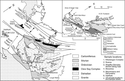
A dramatic example of the usefulness of heavy minerals comes from Ireland’s South Mayo trough. This area of Ordovician volcanic and sedimentary rocks sits within a complex collage of rocks shuffled around by the Caledonian orogeny. It is broadly a syncline in shape, with two sets of outcrops – a northern and a southern limb.

Location of South Mayo Trough. Figure 1 from Mange et al 2010

Location of South Mayo Trough. Figure 1 from Mange et al. (2010)

Today, the South Mayo Trough sits within the Eurasian plate, but it was born in the middle of an ocean that no longer exists.

All at sea

The oldest sediments are found in the Letterbrock formation3.  The sediment matches what you would expect from erosion of the rocks found immediately north of the basin, the Killadangan formation which has been interpreted as an accretionary prism.

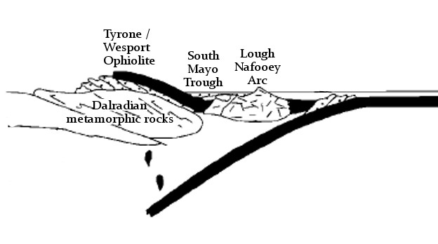
In the south, the sediments correlate with the Lough Nafooey group of volcanic rocks. These formed as part of an oceanic island arc within the Iapetus ocean. Together, this evidence suggests the South Mayo Trough formed as a forearc basin.

South Mayo Trough forming within the Iapetus ocean

South Mayo Trough forming within the Iapetus ocean

The oldest sediments in the north also includes ‘ophiolite detritus’ – grains such as epidote and chromite that are typical of the erosion of oceanic crust. In the overlying Derrymore and Sheefry the ophiolitic debris becomes dominant – serpentine and chromite are so abundant that some beds are unusually heavy and have a ‘soapy’ feel. The volume of chromite increases up through the Sheefry and its chemistry becomes richer in Cr/Ni/Mg. 

Grains of mica and zircon in these rocks have been dated. They show a variety of ages, all Precambrian, consistent with being derived from the old rocks of the Laurentian margin.

During this time, the volcanic rocks of the south show a change in composition. The earliest rocks are basaltic. Patterns of rare earth elements and other geochemical signatures are consistent with an oceanic island-arc origin (only oceanic crust involved). Over time the rocks become progressively more acidic, moving into andesitic and ultimately rhyolitic compositions. Rare earth elements show that the tectonic environment changes. Initially the oceanic island arc magmas were formed from melting of oceanic crust only. Progressively, more and more melt is derived from melting of Laurentian continental crust.

Collision but no mountains

The volcanic rocks therefore record that subduction zone has run out of oceanic crust – the island arc has collided into the continent – the leading edge of which was subducted and melted to feed the volcanic arc.

At the same time as these events recorded in the South Mayo trough, sediments formed on the edge of the Laurentian continent  the Dalradian Supergroup) were being buried, heated and deformed in Grampian/Taconic orogeny. The sediments were buried underneath the oceanic crust (ophiolite) and oceanic island arc as they collided with the continent.

South Mayo trough as part of arc-continent collision

South Mayo trough as part of arc-continent collision

This implies the South Mayo trough itself was part of the upper plate, thrust onto the continent. The work orogeny is synonymous with mountain building, but here we have a sedimentary basin sitting on top of an orogeny, not only being preserved, but continuing to fill up with sediment. Various explanations have been given: the subducting slab and the ophiolitic upper nappe may have been unusually dense. The sedimentary basin, packed with serpentine and chromite certainly was. The sea-level at this time (mid-Ordovician) was unusually high, between 250-500m higher than at present. It’s possible the South Mayo trough was only plastered onto the side of the orogen, not thrusted completely over the top.

Whatever the reasons we should certainly be grateful that the sedimentary tape recorder was preserved. It was still rolling and about to record some more remarkable events.

A  change of direction

Plate tectonics is a global phenomena. The closure of the subduction zone and the arc collision did not stop the overall convergence between the Laurentian continent and the Iapetan oceanic crust. In time another subduction zone formed, this time putting oceanic crust underneath the continent – a change of direction.

While this flip of subduction was taking place, conditions in the South Mayo trough at first didn’t change. The Lower Derrylea formation contains ophiolite debris from north (chrome spinel and purple zircons) and arc debris (clear zircons) from the south.

Diagram showing links events in the South Mayo Trough and other areas. Supporting Appendix. Key to columns: A, Western Newfoundland Ordovician Shelf; B, Notre Dame Bay arc stratigraphy; C, West Newfoundland ophiolites; D, Notre Dame arc ages; E, Quebec.New England; F, Scottish Highlands; G, Achill; H, Connemara; I, Clew Bay Complex; J, Scottish ophiolites; K, north limb of SMT; L, south limb of SMT (thicknesses in K and L in meters), detrital mica ages [71] in SMT; M, Derryveeny; N, Mweelrea; O, Derrylea; P, Rosroe; Q, Maumtrasna; R, Sheefry; S, Southern Uplands accretionary prism; T, detrital mica ages [70] in Southern Uplands accretionary prism.

Diagram showing links events in the South Mayo Trough and other areas. See Dewey (2005) for detailed explanation

Suddenly, around 466 million years ago, while the upper Derrylea formation was being deposited, a massive change occurs. Starting with a single massive thick turbidite bed there is an influx of different heavy minerals. In comes staurolite, almandine and chloritoid, along with floods of muscovite. These are metamorphic minerals and they show Ordovician ages – they come from the metamorphic rocks of the Dalradian.

Dating of these minerals shows that they were hot only 5-10 million years before they ended up as sand grains. Such rapid unroofing of metamorphic rocks suggests something more potent that erosion is at work. The Dalradian rocks in this area show rapid cooling at this time also suggesting something was bringing them rapidly towards the surface. What tectonic mechanisms could explain this?

With the creation of a new subduction zone to the south, the force of the converging plates was no longer supporting the thickened rocks of Taconic/Grampian orogeny. Now in a back-arc position, they extended rapidly. Major faults rapidly brought deep rocks to the surface sending metamorphic minerals cascading into the South Mayo Trough.

Once the Dalradian debris starts flowing, there are no more dramatic changes in the recording. It ends fairly soon after – the whole area is covered by unconformable Silurian sediments – but there is one more thing.

By 464Ma, the whole area is now in an ‘Andean’ type of tectonic environment, with intermediate vulcanism associated with the new subduction zone. This is recorded as ignimbrite layers in the South Mayo Trough, but also as granite intrusions within the nearby Connemara terrane. Once more we are able to make links between the surface and deep processes.

This is what makes these techniques and these rocks, so special. Linking surface to deep processes, resolving timescales to within a million years – these are very powerful ways of understanding how the earth really works.

References

Dewey J.F. (2005). Inaugural Article: Orogeny can be very short, Proceedings of the National Academy of Sciences, 102 (43) 15286-15293. DOI:
Mange M., Idleman B., Yin Q.Z., Hidaka H. & Dewey J. (2010). Detrital heavy minerals, white mica and zircon geochronology in the Ordovician South Mayo Trough, western Ireland: signatures of the Laurentian basement and the Grampian orogeny, Journal of the Geological Society, 167 (6) 1147-1160. DOI:
Brown D., Ryan P.D., Ryan P.D. & Dewey J.F. (2011). Arc-continent collision in the Ordovician of western Ireland: stratigraphic, structural, and metamorphic evolution, Arc-Continent Collision, 373-401. DOI:

Fracking great science from the British Geological Survey

Fracking is rightly a major political issue. In Britain this is topical as the government has just released a technical report showing that very large volumes of natural gas are locked into rocks beneath northern England. As a tax-payer whose house is heated and food cooked using gas, but who is concerned about CO2 emissions and climate change, I will be directly affected whether we extract this gas or if we leave it be.  But what interested me about the report was not politics, not energy policy, but a genuine pride in the quality of unbiased scientific data contained within it. Politics can wait. Let’s celebrate the vast data sets and clear and comprehensive analysis that I’m glad my taxes have paid for.

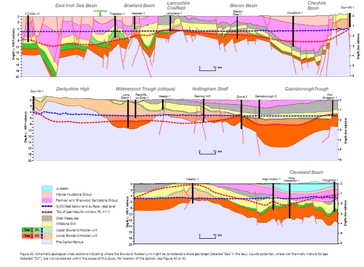
Figure 42, schematic cross sections of the north of England. Copyright DECC 2013

Figure 42, schematic cross sections of the north of England. Copyright DECC 2013

The report sits in a clean and fast web-page, linking to downloadable reports that include a vast amount of data. It’s copyrighted, but I can copy images into here, with attribution. There’s even an apologetic note that ‘users of assistive technology’ may not be able to make use of the files.  This is how all government websites should be.

The study focuses on a particular geological unit that covers much of the north of England, the Bowland-Hodder shale. For a geological introduction, I can’t better the report itself: “Marine shales were deposited in a complex series of tectonically active basins across central Britain during the Visean and Namurian epochs of the Carboniferous (c.347-318 Ma). …. The marine shales attain thicknesses of up to 16,000 ft (5000m) in basin depocentres (i.e. the Bowland, Blacon, Gainsborough, Widmerpool, Edale and Cleveland basins), and they contain sufficient organic matter to generate considerable amounts of hydrocarbons.” 

The study identifies draws on a mass of seismic and borehole data and distinguishes two horizons, an upper and a lower. The upper is a post-rift deposit that resembles “prolific North American shale gas plays”. The lower is less well known (not much drilling information) but was deposited during the rifting and so is a thicker deposit. Here’s a sense of how much data they are  drawing on:

Figure 8. Copyright DECC 2013

Figure 8. Copyright DECC 2013

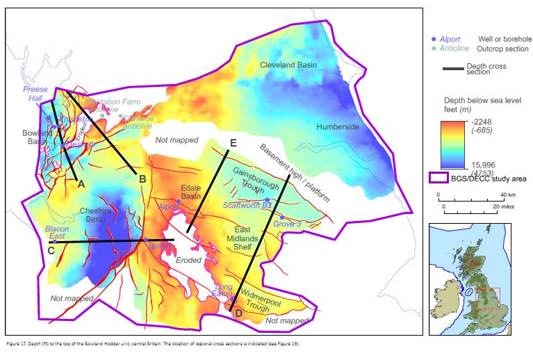
Seismic data gives you a cross-section view through the sedimentary layers. Borehole data allows you to link the layers to actual rocks. Gamma ray logging data allows you to estimate the amount of organic matter within these rocks. The report tells you how the deep the shale is:

Figure 17. Copyright DECC 2013

Figure 17. Copyright DECC 2013

It has other pretty maps showing how thick the layers are, plus lots of cross-sections.

These rocks started as mud with organic matter in them. This only turns into valuable oil or gas once that organic matter has been buried and heated. The shininess of woody matter from boreholes (called vitrinite reflectance), records how much the rocks have been heated. Particular values of vitrinite reflectance correspond to a ‘gas window’ indicating that shales with organic matter are likely to contain methane gas.

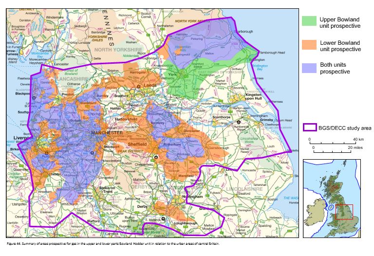
Putting all this data together, the British Geological Survey guys have produced maps of areas where the upper and lower units exist and have passed through the gas window.

Figure 44. Copyright DECC 2013

Figure 44. Copyright DECC 2013

What the man in the street wants to know is: how much gas is there? The study uses a Monte Carlo analysis of the various parameters to come up with an estimate. In layman’s terms, there is an enormous amount – around a quadrillion cubit feet. Even allowing for the fact that fracking can only extract a small proportion, the amounts are easily comparable with the conventional gas reserves already extracted from the North Sea.

I’ve barely scratched the surface of the data contained in these reports. I’m sure there are many geologists employed by industry studying them intently, but note that as far as I can tell, all of this data is provided by the British Geological  Survey. Will this report result in many more holes being drilled into the north of England? Only time will tell.

Dalradian – a Celtic Supergroup

Geology is such a great thing to study because it involves making so many connections through time and space, switching scales from the cosmic to the atomic. This means that challenge for this series of posts about the geology of the west of Ireland is going to be managing scope. So. Although I could start with the big bang, I won’t. I’ll start with the Dalradian.

A thick package of sediment, the Dalradian Supergroup, or just Dalradian, to its friends was  was named in the 19th century after Dál Riata a minor kingdom in 6th and 7th century Scotland. Dál Riata was an Irish colony within Scotland, appropriately, as Dalradian rocks are found over much of Highland Scotland and NW Ireland.

A Celtic Supergroup

To fans of 1970s Prog Rock, a supergroup is a band formed from musicians who made their names in other bands. For geologists, it means a bunch of groups that are bound together, a group being a large recognisable package of sediment. The groups usually sit on top of each and represent a period of time during which sediment was deposited. For both types of supergroup, the individual members often have distinctive personalities.

The Dalradian Supergroup is made up of the Grampian, Appin, Argyll and Southern Highland groups.

The Grampian is the solid foundation of the Dalradian, fairly calm and ordinary: the bass guitar player of the supergroup. It is a 7-8 kilometre thickness of sandstones and muddy sandstones*. In Ireland, Grampian Group sediments are found only in North Mayo.

The Appin is the lead singer: shallow, good looking and gets lots of attention. Its made up of sandstones, limestones and more muddy sediments all deposited on a marine shelf in shallow water. Now somewhat changed, it contains some gorgeous rocks.

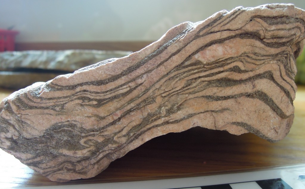
Glencoe Quartzite, Appin Group

Glencoe Quartzite, Appin Group

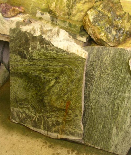
Picture of Connemara marble from

Famous ‘Connemara marble’ which is from, er, Connemara in Ireland. Picture credit.

The Appin group is found in the heart of Connemara, also across Mayo and Donegal.

The Argyll is the lead guitar. It’s deeper than the Appin and has been through some pretty intense times – brushes with death in fact. It contains the familiar sandstones and muddier sediments, but also more exotic sediment types.

Twice in the Irish Dalradian there occurs an odd pattern of rock-types. First there is a layer of sediment filled with angular fragments with a wide range of  sizes, called a diamictite. A number of subtle features show that it is sediment left behind by a glacier – it is a tillite. Immediately above is a layer of carbonate, a limestone or a dolomite. Such rocks usually form in nice warm parts of the earth so the association with glacial deposits is odd. The first of these tillilte-carbonate pairs can be traced across the Dalradian, indeed across the world. These are ‘snowball earth’ deposits. Some believe that at this time the entire earth was covered in ice, with glacial deposits forming near the equator. The overlying ‘cap carbonates’,  contain unusual carbon isotope compositions suggesting to some that life on earth nearly died at this time. This happened not just once, but twice in the Argyll.**

Picture of Argyll group sediments making up the Twelve bens mountains of Connemara. Image from Guilhem Boyer

Picture of Argyll group sediments making up the Twelve bens mountains of Connemara. Image from Guilhem Boyer on Flickr under Creative Commons.

The Argyll is rounded off with molten lava spilling into the sedimentary basin. Dangerous to be around for sure, but the Argyll makes the supergroup as a whole much more interesting and ‘edgy’.

The Southern Highland group is the drummer: completely crazy. The ground’s falling away under your feet, with sediments pouring into deep water and there’s another snowball earth episode***, there are big lumps of serpentinite, plus molten lava keeps coming out of the ground: madness. There’s a problem with ‘groupies’ as well. Lots of areas of sediment that say they’re ‘with the band’ but no-one is quite sure. Some of these, rocks along the Highland Boundary fault in Scotland or in Clew Bay in Ireland are worryingly young as well – Cambrian or even Ordovician. They’ve caused a lot of arguments, as you can imagine.

Song about a break-up

The Dalradian sing sad songs, about break-up: continents who once ‘were as one’ but who gradually drifted apart. It was a ménage à trois, so it was bound to end badly.

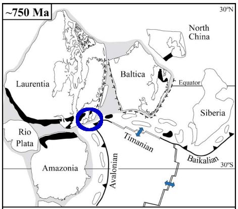
The song starts with the continent of Rodinia about 730 million years ago. This already had a rich and complex geological history which led to the creation of a large supercontinent consisting of pieces that now make up Scandinavia (Baltica), North American and NW Ireland and Scotland (Laurentia) plus Amazonia. Of course at the time these distinctions didn’t exist – it was simply a large single continent.

Rodinia 750 million years ago. From Cocks & Torsvik 2005

Rodinia 750 million years ago. From Cocks & Torsvik 2005

Cracks were starting to show, however. The Grampian Group formed in a rift basin, where Rodinia was starting to break-up. Early variations in the thickness of sedimentary layers suggest that faults were active during deposition. Times when the sedimentary basin became dramatically deeper also suggest tectonic involvement – active rifting was stretching the basin. There wasn’t a full break-up, however. Rifting ceased and a 30 to 40 million year period of calm saw the Appin group deposited in shallow waters under stable conditions.

The Argyll group saw rifting start-up again. By the end of the Argyll (600 million years ago) it became clear the split was going to be permanent. The stretching of the crust allowed the underlying mantle to melt, producing a ‘bimodal magmatic event’ with the intrusion of granites and the eruption of basaltic lavas. By Southern Highland group times, the sediments were forming in really deep water. Large bodies of serpentinite found in Ireland suggest the crust was stretched so much that material squeezed out from the underlying lithosphere.

This final extreme stretching marks the opening of a new ocean, called Iapetus. The opening of Iapetus created sedimentary basins all along the Laurentian margin. The Fleur de Lys Supergroup in Newfoundland and the Eleonore Bay Supergroup in Greenland were deposited in adjacent, equivalent basins. Further south in the US Appalachian belt, sedimentation associated with the opening of Iapetus starts only in Cambrian times.

Sing something simple?

I’ve told a nice simple tale, based on current scientific consensus, but it used to be much more complicated. The problem is that these are no longer sediments. Key concepts in both metamorphic and structural geology were developed on these contorted, baked and squashed rocks. Seemingly simple things like identifying the base of the Dalradian is extremely difficult as the rocks below are often also metamorphosed sediments, first transformed before the Dalradian and then deformed and heated again alongside it. Drawing a line between two types of schist requires extremely careful analysis.

The Dalradian is intruded by many granites. Most are older than the deformation, but some are younger, intruded into deep sediments in the Dalradian basin while sediment was still settling on the surface above. A date of 590Ma for one of these ‘Older Granites’ caused years of academic chaos in the 1990s as the granite was initially (incorrectly) thought to post-date the deformation, meaning that any younger sediments couldn’t belong to the Dalradian.

Geological histories hinge on tiny facts. The age of single zircon grain, a fabric wrapping an andalusite crystal: great geological narratives are built from or destroyed by such tiny pieces of evidence.

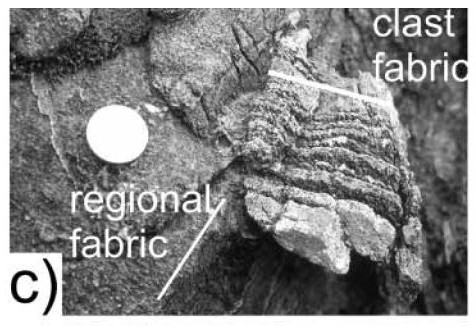
Evidence of mountain building episode during the Dalradian. From Hutton & Alsop 2004 GSL.

Evidence of mountain building episode during the Dalradian. From Hutton & Alsop 2004 GSL.

There is one inconvenient fact that might bring the whole of the simple story crashing to the ground. Respected researchers working in Donegal (Donny Hutton and Ian Alsop) have mapped an unconformity within the Argyll group. This could be consistent with our story – unconformities can form within sedimentary basins – but they interpret it as an orogenic unconformity. Based on various lines of evidence, including a tectonic fabric within sedimentary clasts above the unconformity, they infer a entire episode of mountain building took place during the gap in sedimentation shown by the unconformity. 

So is the Dalradian a single package of sediments formed during the opening of an ocean, or two packages separated by a previously unrecognised period of mountain building? I’ve no idea, but hopefully time will tell.

Regardless, everyone agrees on what happened next. Iapetus no longer exists: it opened and then it closed, moving the Dalradian from a sedimentary basin into the core of a mountain belt. That’s where we’re going next.

——————————————————————————————————————-

*they’re not sandstones any more, but we’ll come to that

** the first, the “Port Askaig Tillite” is correlated with the Sturtian global event at c. 700Ma. The second ‘Stralinchy diamictite’ with the Marinoan at c. 635Ma

*** the Inishowen and Loch na Cille beds are correlated with the Gaskiers global event at c. 580Ma

 References

L. Robin M. Cocks, & Trond H. Torsvik (2005). Baltica from the late Precambrian to mid-Palaeozoic times: The gain and loss of a terrane’s identity Earth-Science Reviews DOI: 10.1016/j.earscirev.2005.04.001

D.H.W. Hutton, & G.I. Alsop (2004). Dalradian Supergroup of NW Ireland
Evidence for a major Neoproterozoic orogenic unconformity within the Dalradian Supergroup of NW Ireland Journal of the Geological Society DOI: 10.1144/0016-764903-094

David Stephenson, John R. Mendum, Douglas J. Fettes, & A. Graham Leslie (2013). The Dalradian rocks of Scotland: an introduction Proceedings of the Geologists’ Association DOI: 10.1016/j.pgeola.2012.06.002

Mantle support of topography – a swell idea

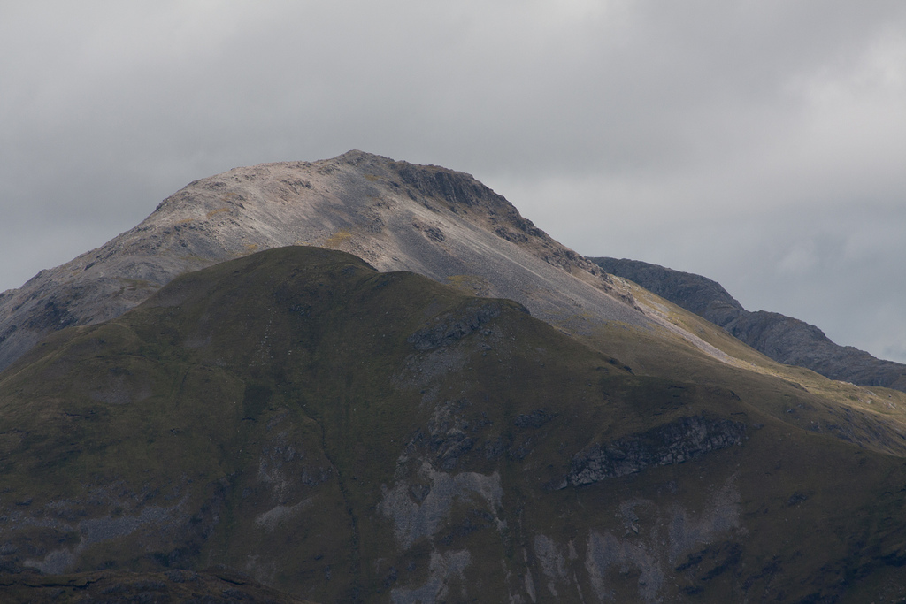
Cathedral Peak area at sunrise - Ukhahlamba Drakensberg National Park, South AfricaWhy are some bits of the earth higher than others? Finding mountains near plate boundaries is easy to explain – various forms of plate collision cause the crust to thicken and the surface to rise. What about Southern Africa?

Reaching a high point of 3473m, most of Southern Africa is a high plateau. It is not tectonically active – the sedimentary layers in the photo are still horizontal – but they are more than a kilometre higher than they ‘ought’ to be. Why?

African swells and superswells

In recent GSL paper, Stephen Jones, Bryan Lovell and Alistair Crosby argue that the topography of Southern Africa can be explained by mantle convection pushing the crust upwards – that flow of the mantle has a direct influence on surface topography. They go onto argue that this phenomena also controls patterns seen in ancient sedimentary basins.

A spot of theory first. On the scale of 100s of kilometres topography is controlled by the properties of the lithosphere – the Tibetan Plateau can be explained this way. But over scales of 1000s of kilometres the lithosphere isn’t strong enough. On this scale, variations in height can only be explained either because the lithosphere is thicker, or because it is being pushed up from below.

Our authors look at Southern Africa and Antarctica, areas far from convergent plate boundaries. Studying the patterns of topography and gravity, they argue that the main geographic features can be explained by dynamic support from mantle convection. So the Drakensberg mountains (pictured above) are high because they sit above a portion of the mantle that is rising, pushing the plate (and the surface) up. The low-lying Congo basin, further north sits above a descending part of the mantle.

They paint a picture where “thousand-kilometre scale dynamically supported swell topography is the norm for continental regions that are not influenced by subduction zones“, suggesting that areas such as eastern Australia, peninsular India, central USA, east Africa, eastern USA, the Siberian Shield and eastern Siberia are all  affected by similar long ‘topographic swells‘. The African swells they study in detail are around 2000km in diameter and between 1.4 to 2.7km in height.

This is a tremendously important idea, suggesting that the broad patterns of the landscape can be explained by slow movements of rock deep under the surface. Patterns of convection within the upper mantle subtly change the shape of the earth we stand on. More, there is talk of an Southern Africa superswell, over 10,000km in size. A long wavelength warping of the earth’s surface that the other swells sit on and which could be partly supported in the lower mantle.

One of the beautifully elegant things about earth sciences is the way we discover that apparently unrelated aspects of the earth are linked. Discovering such a linkage provides insights into both things simultaneously. So, discovering that topography is related to mantle convection gives you new ways of understanding both. For example looking at sedimentary sequences sitting on these African swells allows us to work out how long the swell has existed for (40 million years). This in turn is an insight into the timescales of convection within the mantle hundreds of kilometres under the surface.

To the UK

The concept of dynamic topography is not new to this paper, (there was a conference about it last year), it adds importantly to the debate by quantifying  both modern day swells in Africa and ancient swells in sedimentary basins.

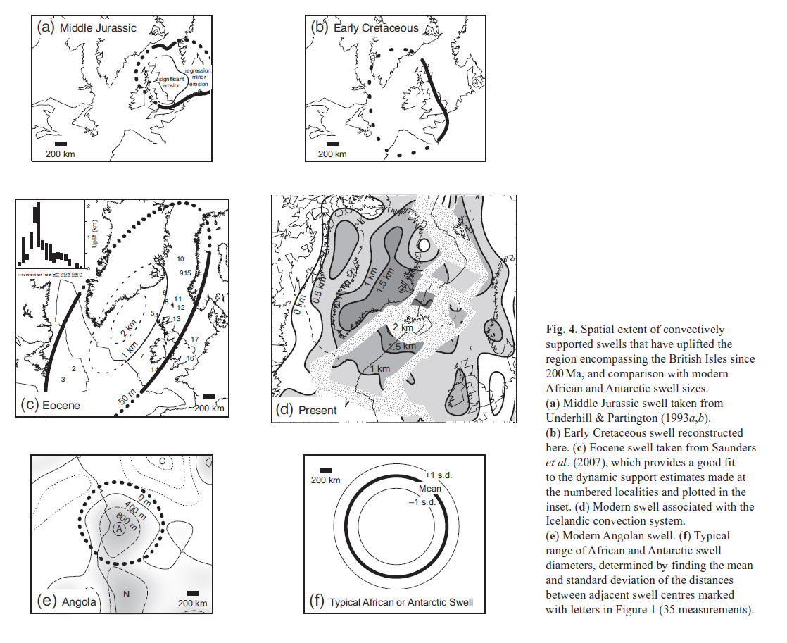
The UK, Ireland and associated oceanic basins make up a stable piece of crust with a long sedimentary record. There is a long and successful history of hydrocarbon exploration in the area, so there is lots of data to draw on. Our authors describe four swells from this area in the last 200Ma, active in the Jurassic, early Cretaceous, Eocene and present day (based on Iceland).

Figure 4 from Jones et al 2012. Reproduced under Geol Soc fair use policy

The evidence presented suggests that these ancient swells are similar in dimensions to present day African ones and formed over similar timescales, growing in 5-10Ma and decaying over 20-30Ma.

A fail for Vail?

The effect of these swells on sedimentary sequences is dramatic – a kilometre of uplift turns a sedimentary basin into an area of erosion. Dynamic support is not just of interest to students of the mantle, but also to lovers of sedimentary basins or those who seek the oil and gas found therein.

It’s been long understood that patterns of sedimentation are controlled by tectonic factors (creating holes with extensional or foreland basins) and by sea-level changes. In the 1970s, the work of a group at Exxon led by Peter Vail transformed the study of sedimentary basins. Their new techniques of sequence stratigraphy showed that patterns of sedimentation are best explained by different cycles of changing water depth (relative sea-level). The level of water within a typical sedimentary basin is constantly changing on both high and low frequencies.

Note that this relative sea-level change can be caused either by moving the surface of the earth or moving the surface of the water. Vail ‘chose’ to move the surface of the water and sought to explain local patterns in terms of global “eustatic” sea-level change. During periods of glaciation there is a plausible mechanism for doing this and the model is successful (for example, the Carboniferous of the UK). A longstanding problem is how to create cycles of sea-level if there are no ice-caps to vary in size and periodically change the volume of sea-water.

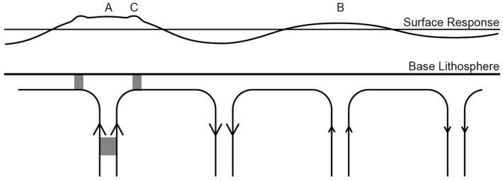
In his 2010 Presidential Address for the Geological Society of London, Bryan Lovell challenges the Vail hypothesis asserting that “mantle convection provides an alternative, regional, mechanism to eustatic control for explaining medium-frequency to high-frequency sea-level cycles“. Relative sea-level changes can be explained by moving the surface of the earth in a particular area. Over a mantle swell, basins will be shallower or stop being basins even if global sea-level remains constant.

Figure 2 from Lovell 2010. Reproduced under Geol Soc fair use policy

Lovell proposes a mechanism to explain the different frequencies of cycles. Mantle swells, created by convection cells, work over the 10-40 Ma timescale. He proposes that ‘hot blobs’ (grey patches above) move within the wider cells. The blobs cause their own smaller scale (and faster moving) ‘mini-swells’ that explain the higher frequency patterns seen in sediments.

What I like best about the idea of dynamic mantle support of topography is that it is testable. By starting to quantify the time and length scales of mantle swells it becomes possible to recognise them reliably in the stratigraphic record. Changes due to global sea-level variation will be correlatable across many basins whereas mantle swells will not.

Its another way of thinking about the earth, too. As someone living on a tectonically quiescent patch of the earth I’m used to thinking of nothing much happening here until the Atlantic starts to close again. It turns out that “there is no such thing as a stable continental platform” and that a change in the way rocks are flowing deep below could move Britain up or down by a kilometre within as little as 10 million years.

References

Picture of Drakensburgs via Palojono on Flickr under Creative Commons.

Jones, S., Lovell, B., & Crosby, A. (2012). Comparison of modern and geological observations of dynamic support from mantle convection Journal of the Geological Society, 169 (6), 745-758 DOI: 10.1144/jgs2011-118

Lovell, B. (2010). A pulse in the planet: regional control of high-frequency changes in relative sea level by mantle convection Journal of the Geological Society, 167 (4), 637-648 DOI: 10.1144/0016-76492009-127