Volcanoes and mass extinctions – tracking a killer

Look in a bookshop and see how many shelves are taken up with murder mysteries. There’s little that is as compelling as the idea of a dead body on the ground and a search to find the culprit. I’m going to try out the genre here today. I can promise you the deaths of entire species, a glamorous prime suspect with spectacular methods and an overlooked serial killer who has poisoned many different victims. I can’t promise you detectives who are troubled mavericks who break the rules, but there are geologists who sometimes feel like they are underdogs.

The dinosaurs were killed by a giant impact. There’s little debate in the public mind about that and the role of extraterrestrial impacts on earth’s history is now inarguable (I’ve written about it myself). Sometimes though it irritates me how much focus is put on speculation about extra-terrestrial causes for mass extinctions. The worst example I’ve seen is speculation that dark matter (that we don’t understand) has caused past extinctions. Glamorous ideas about Death From Space, which (with the exception of the Cretaceous-Palaeogene) event have little supporting geological evidence always seem to get attention.

This makes me grumpy because geologists have a perfectly good explanation already. A serial killer stalks earth’s history. It doesn’t kill by flaming impact (or however dark matter is meant to work) but by poisoning, choking the life out of countless plants and animals. Death From Above is spectacular but Death From Below, a murderous force rising slowly and unstoppably from the Earth’s core is much creepier.

Forensic evidence

Mass extinctions leave an unusual sort of murder scene. Instead of there being a single dead body, there is a sudden lack of them, as fossils of particular species disappear from the geological record. For a normal murder, you would study the body for any clues, any evidence of what killed it. Same with a mass extinction, only you look in the layers of rock round about where the fossils run out.

These need to be places with a continuous sedimentary record, where we have sediments from the age of the extinction. Often these are marine sediments, which can contain relatively large volumes of small fossils. Chemistry is the best form of forensic evidence as it gives us an insight into the state of the ocean over time. Carbon isotopes track the ebb and flow of the Carbon cycle and often the extinction horizon is associated with a sudden change in them. This means that rocks from the time of the extinction event can be found even in layers with few fossils.

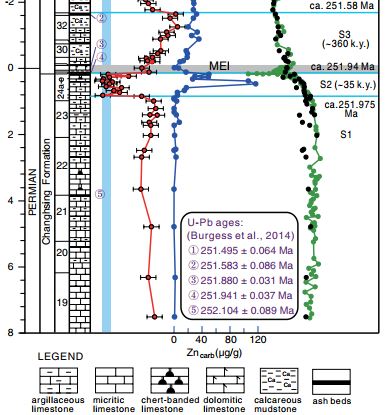
The K-Pg event (RIP non-avian dinosaurs, plesiosaurs, ammonites), is famously associated with a layer rich in Iridium, an element rare on the earth’s surface but much more common in material in space. Similar connections are found between other extinctions and Zinc. The P-Tr event (RIP trilobites, nearly everything else) shows a spike of Zinc in marine sediments immediately before the extinction. A recent study (Liu et. al 2017) also shows how the isotopes of Zinc change over time. Zinc is an important nutrient for marine phytoplanktons, meaning their growth changes the isotopic ratio of Zinc in marine sediments. Using this they demonstrate not only that more Zinc is found, but that it came from volcanic or igneous material entering the ocean. This happened abruptly around 35 thousand years before the extinction event. Soon after, the ratio shifts back in a way consistent with phytoplankton activity returning to normal within 360 thousand years.
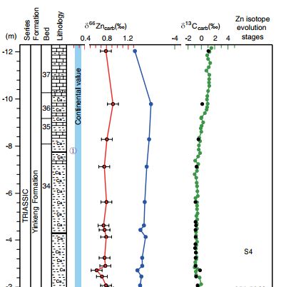
Liu figure 2a


Figure 2b from Liu et al. Showing Figure 2b from Liu et al. Showing changes in Zinc concentrations and isotopic ratios immediately before the Carbon isotope changes associated with the extinction event.

Other studies show anomalous peaks of Nickel abundance just before the P-Tr event in many sections across the world. Once again the source is inferred to be volcanic activity. Different sets of forensic evidence point to an obvious suspect – the Siberian Traps – an enormous area of volcanic rocks covering a huge area of Russia that was formed across the P-Tr boundary.

The Murder weapon

Volcanic eruptions are dangerous to be near. It’s obvious why life suddenly swamped by lava will not survive, but a mass extinction is a global phenomena. How can a volcanic area kill animals or plants on the other side of the world?

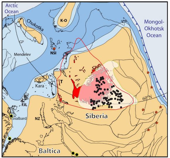
Jerram figure 1

Figure 1 from Jerram et al.

Figure 1 from Jerram et al. showing extent of Siberian Traps, highlighting sill intrusions, coal and explosion pipes.

One clue comes from odd structures found around the Siberian Traps, for example within the Tunguska Basin1. These structures are pipes called diatremes, formed by gaseous explosions.

Some diatremes are formed by gas ready mixed within the magma, but with these Siberian pipes the gas came from heating of the sedimentary rocks that were already there. Buried below the many lava flows, are flat sheets of rock called sills that pushed between existing sedimentary layers. These sills heat up the surrounding rocks, which in the Tunguska basin include much coal and evaporite rocks. This heating produced vast volumes of CO2 and CH4 that poured out of the pipes into the atmosphere.
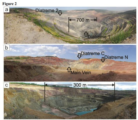
Figure 2 from Polozov et al. Showing portions of basaltic pipes, exposed within mining works.

Figure 2 from Polozov et al. Showing portions of basaltic pipes, exposed within mining works.

These gases of course affect the climate. A huge outpouring of CO2 and methane, plus also nasty gases such as SO2 represent a pretty convincing murder weapon. A brand new paper demonstrates malformed parts of terrestrial plants about this time, attributed to pollution. Sudden ocean acidification and climate change followed by a collapse in planktonic growth leading to the the death of the dependent food webs is a uncontroversial story. It may be a story we are beginning to retell as gas forms mysterious holes in the ground in Siberia once more.

Killed and killed and will kill again

The Siberian Traps are just one of many Large Igneous Provinces (LIPs). Other ones are also associated with extinctions. The pleasingly named CAMP province, found in Atlantic facing areas of Africa, Europe and the Americas, overlaps in time with end-Triassic mass extinction event (RIP conodonts and various reptiles & amphibians).  An open-access paper from mid 2017 demonstrates a link between sills intruding into organic-rich sediments and the extinction event – exactly as proposed for the P-Tr event.

Figure 1 from Davies et al

Figure 1 from Davies et al

The bodies are piling up. The Late Ordovician extinction event (RIP 85% marine species, no big groups) has been linked to Mercury enrichment in marine sediments. The authors link this to a LIP, even though one of this age has not yet been found.

What do we know about this serial killer? LIPs are thought to be formed by huge plumes of rock, rising from the edges of odd features on the very floor of the mantle. Their ability to kill may depend on the nature of the crust they rise into. Both the P-Tr and Tr-J events see sills intruded into sediments. The Deccan Traps, active across the extinction of the dinosaurs (K-Pg) rose through basement rocks, so there were no sediments to heat, meaning they pumped out only volcanic gases. Maybe this is why the extinction event required an impact to finish the job.

Case for the prosecution

“So, ladies and gentlemen of the jury, I suggest to you that the accused is a serial killer. The mighty plesiosaur, the ever-busy scuttling trilobite, even the wriggly conodont, all were killed by the monster sitting before you. It killed, not by showy eruptions and square miles of lava, but by the silent injection of sheets of magma deep underground. This devilish act then poured huge quantities of poison into the air, bringing the very earth to its knees.”

We’re not quite ready for a trial. Some of the evidence is circumstantial and we certainly don’t have a full roster of victims. But LIPs should be high on the list of anyone’s list of suspects for the greatest murders the world has ever seen.

Sediment and sea: from the heights to the depths

This study in blues and greys and browns, this combination of fuzziness and sharp edges, where is it?

It’s where land and ocean meet and mingle. A place where mud and silt and sand pause half way along an incredible journey that links the destruction of mountains to the creation of new land.

It’s an aerial view of the sea offshore from the Sundarbans, a vast area of tidal mangrove forest in India and Bangladesh. Sitting in the eastern elbow of the Indian subcontinent this is where the water from the Ganges and Tsangpo-Bhramaputra rivers enters the sea.

What makes the picture interesting is the dynamic shifting patterns of the sediment under the water. Water that when madly dashing down-hill had the power to carry sediment, but now it’s reached the sea it slows down and the sediment starts to pile up. Tiny clay minerals that were happily floating in suspension in fresh-water suddenly clumped together and sank in the salty sea1. The shape of the land here is caused by this process, plus the influence of the daily tides and the sinking of the ground as the sediment squashes down into itself. Fractally-frequent creeks and rivers snake their lazy way across near-flat terrain making it dangerously sensitive to changes in sea-level.

What is the sediment?

The sediment in this image came from the Himalayas. Some of came from near Mount Kailas and moved nearly 3,000km along the Tsangpo river tracing a line parallel to and north of the Himalayas. Cutting through the Himalayas at the Namche Barwa syntaxis the river cuts deep into the earth, eroding so deeply that the hot rocks beneath are flowing up to fill the hole, like jam oozing from a cut doughnut.

Map of the Yarlung-Tsangpo-Bhramaputra river. Image source.

Map of the Yarlung-Tsangpo-Bhramaputra river. Image source Wikipedia.

Often we are taught erosion as a gradual, calm almost civilised process. Not necessarily. Some of this sediment did indeed start as a small grain popped of an outcrop and rolled gently into a mountain stream. But more of it comes from boulders in glaciers scraping and scratching the rocks beneath, the resulting rock flour staining the glacial streams a milky blue. Or maybe from where the river cut a slope impossibly steep and a huge landslide smashed the rock into pieces. Or where the landslide dammed the river, until inevitably the water overtops it and a huge boulder-rolling crushing scouring flood sweeps down the valley.

Where the sediment came from

Sediment isn’t just generic stuff, it’s made of minerals, each with a character and a history of its own.

The sediment carries traces of the intense underground events that formed the mountains. Simple sand can be quartz crystals freed from ancient sandstones, born in the vanished Tethys ocean. Yet transformed in the meantime, crystals lattices rotated, grain boundaries switching and twisting as the rocks were heated and deformed.

More dramatic still is the story of the clay. Layers of silicates like illite or chlorite, packed higgley-piggledy with all manner of atoms, lazy and relaxed, suited for a soft low-pressure life on the surface. But these minerals are new, results of chemical weathering, a decline, a descent from what was once strong and pure2. Metamorphic minerals forged in the mountain’s heart: sparkling muscovite; kyanite, face lined from the pressure; hot-headed sillimanite, bushels of fibres bursting out the guts of the biotite it was feeding on.

These are strong minerals, forged under intense conditions. But under the attack of water, oxygen and sunlight they turn back into the clay the originally formed from. Some metamorphic minerals can survive longer at the surface, garnet, zircon and others form a very small part of the sediment load, but one that can tell us a great deal about where they’ve been.

Where it’s going

The sediment patterning the sea-bed in the image above has not reached the end of its journey. Sediment that joined a river perched 5 kilometers above sea-level is still nearly the same height again above the vast deep plains of the Indian Ocean.

Sediment flows downhill under water just as well as it does on land. Submarine channels are formed by turbidity currents – fast flows of sediment-filled water that travel vast distances down into the deep ocean. These undersea rivers have banks and trace sinuous patterns on the surface just like their cousins above land.

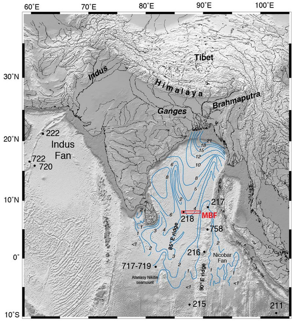
For over 20 million years, sediment flowing into the ocean from the Himalayas has formed the Bengal fan, a triangular pile of sediment that is 3000 km long, filling nearly all the sea-floor between the Indian sub-continent and south east Asia.

Blue lines are thickness of sediment in the Bengal Fan. Image Source.

Blue lines are thickness of sediment in the Bengal Fan. Image Source: IODP Red box is location of this year’s drilling.

This is no thin layer either. In places the pile of sediment is over 20 km thick. The oldest sediments are buried so deep they must now be metamorphic rocks3.

The total volume of the fan has been estimated to be4 12.5 million cubic kilometres. That’s enough sediment to cover the whole of Britain with a 100 km thick pile, or even the USA with over a kilometre5.

Assuming most of the sediment came from the Himalayas, which have an area of a million square kilometres, this implies that since the mountains were formed around 12.5 km of rock has been eroded off the top6. This makes sense – much of the High Himalaya is made of metamorphic rocks formed beneath the mountains and since exposed by erosion. 7.

Linking sea and mountain

This makes the fan a time-machine. Geologists who study the Himalayas, who want to understand its history, can use cores of sediment from the fan to understand what happened in the past. What metamorphic minerals were being washed off the mountains 20 million years ago? What age where they? Are there traces of the Monsoon (which is caused by the high Tibetan Plateau) at this time? The International Ocean Discovery Program (IODP) were drilling here earlier this year to answer exactly these questions.

The beautiful image we started with is from the boundary between land and sea, but the links between these two domains are many and important. Rocks that once sat kilometres above those now forming the modern High Himalaya now sit, shattered and decayed in the deep sea thousands of kilometres away. Erosion is focussed in the Himalaya partly due to monsoon rains, where moist air from the Indian Ocean is drawn onto the land by heating of air above the high mountains. Formation of the Indian Ocean crust pushed the Indian continent away from its location next to Africa to smash into Asia and form the mountains in the first place.

One day the plates will rearrange themselves and the Indian ocean will be destroyed and some of these rocks will once again find themselves on land, perhaps high in a mountain range waiting to go on another incredible journey back into the deep sea.

Great Geology in Google Maps: mapping from above

In most cases, geological maps are made by piecing together observations of hundreds of individual outcrops. Boundaries between types of rock are covered in grass and sheep1 and have to be traced on the map later as a line between rock outcrops, like a inverted game of dot-to-dot. In areas like Himalayas the same boundaries may be visible in an instant on a vast wall of rock. Quickly mapping vast areas of country by tracing features by eye across expanses of bare rock is a great way to do geological mapping.

It turns out you can have a go at this ‘Himalayan-style’ mapping at home. Make a cup of tea (add salted butter, or spiced sweet milk for authenticity) and fire up Google Maps. It works outside the Himalayas too – deserts are great for this.

This is an area of Namibia in SW Africa. Immediately you can see different areas of rock – the image itself is like a geological map, only without labels. Himalayan geologists would identify the different areas of rock by getting samples, but we’ll stick with Googling the geology of the area.

Let me take you through the geological components and their history.

First off, the orange lines that look like rivers. Ignore them: they are rivers and we are geologists, not geographers. Mentally filter them out of the image.

damaraNext look at the stripy area top left – we’ll call them the Damara sediments. They formed in the long-vanished Khomas ocean between the Congo craton (ancient piece of crust) and the Kalahari craton. The area is stripy because the sedimentary layers are not flat. They are now on edge and form ridges on the surface.
dgraniteThe light orange area far right is made of Damara granites (and modern sand, again filter it out, if you can). These formed when the Khomas ocean closed and Congo and Kalahari got stuck together as part of Gondwanaland. This happened about half a billion years ago.

KarooBottom left, the rusty brown area is sediments and volcanic rocks that are part of the Karoo Supergroup. These formed on Gondwanaland between the Carboniferous and the Jurassic when geological conditions in this part of Africa were relatively calm.

Brandburg3

The really obvious round thing that I’ve perversely left until last is a circular granite intrusion called Brandberg that formed a little later, as Gondwanaland was ripped apart and the South Atlantic opened.


I’ve given you the relative ages of the different rock packages, but we could have worked this out from Google Maps. The observations I’ll show you are exactly the same as those used by field geologists. What follows are a sequence of close-ups. Some are outside of the original area, but none are far away.

Unconformity

We’ve got two areas of sediments, the Damara and the Karoo. How do we know one is older than the other?

Here we see the red-brown Karoo sitting in a blob in the middle, with stripy purple-brown Damara to the NE. Look carefully (zooooming helps) and you can see circular lines in the Karoo. Note that the rivers go round this blob.

We are looking at a hill of Karoo sediments. The lines are the edges of different beds and they are tracing contours around the hill. These are flat layers of underformed sandstone2.

Try tracing the lines in the Damara – these are also the edges of sediment beds but they have been tilted. Note that they are cut by the edge of the Karoo. The surface between the two rock packages is an unconformity. It represents the time when the Damara sediments were pushed into a mountain belt and then eroded into a flat surface.

Folding and cross-cutting granites


This is a view of the contact between the Damara granites and the Damara sediments, which have some zig-zaggedy folding here. The boundary between the two is fairly abrupt and cuts the folded bedding planes. Using the principle of cross-cutting relationships the granite is younger than the sediments and the folding (although the folding may be related to the emplacment of the granite). There are some fine white lines crossing the folded sediments that may be veins of magma that came out of the main granite – further evidence of what came first.

Scoot around a bit and you can see that there is an unconformity between this older Damara granite and the Karoo, which gives us the relative ages of the three.

Three-way contact


This is a view of three of our rock packages. There’s a prominent river forming a yellow bar across the picture. Apart from that, from left to right we have: Damara sediments; Karoo sediments, sitting above the unconformity; the Brandberg granite. The boundary between the Karoo and the Brandberg is straight and cuts across bedding, suggesting the intrusion is later.

Another possibility to consider is that this is an older granite and the edge is just the edge of a hill. Well, look a the patterns of the streams – they are flowing down from the centre of the granite (it actually forms the biggest mountain in Namibia). For it to be higher now than the flat Karoo sediments, it must be younger than them.

The boundary between the Brandberg and the Karoo is quite interesting3, with tilting of the Karoo and a zone where the sediments and granite are mixed. Apart from the small zone that is Karoo coloured but without clear bedding, I can’t make this out.

The geological history I started with is based on many things, including precise dating of events and detailed field work. However, the basic age-relationships between the rocks can be worked out using simple geological rules and good photographs.

These same principles are being used on other planets where geologists have never been. We know a lot about the geological history of Mars by mapping from space using just these techniques.

Damara granite next to folded Damara

Great Geology in Google Maps: dunes

Google Maps is a great resource, particularly in satellite view. My favourite way to enjoy it is via the Chrome extension “Earth View from Google Maps“. This pops up a gorgeous image in every new tab. Many show human landscapes, but every now and then one appears that catches this geologist’s eye. This post is the first in a series exploring and celebrating these images.

This view is of the Rub’ al Khali or ‘Empty Quarter’ of the Arabian Peninsula – the largest sand desert in the world.

In dry environments sand is moved not by water but by wind. The characteristic landform is the sand dune. Common in deserts on earth, they are also found on Mars and even comets.
The shapes of dunes depends on the supply of sand, but above all the wind. Wind strength and direction, averaged over the year, will determine the shape of a dune. Various types of dune are recognised. The ones in this image are complex. Further east of here the dunes are clearly linear features, but here the lines are broken up into loops reminiscent of arabic script.

Look carefully and you’ll see that there are dunes upon dunes. The surface of the large sand bodies are covered in ridges and patterns with a wide variety of shapes. These themselves may have small ripples on, only visible if you visit in person.
 

This image is from the ‘Grand Erg Oriental’ in the Sahara desert in Algeria. It shows star dunes, which form when the wind is variable and simply piles the sand up into mounds 100s metres tall.

Both these areas of sand (by chance) sit above oil-fields, the oil-bearing rocks sitting deep under the ground. Ancient desert sands are of interest to oil geologists as the grains are very round and form sandstones that can contain a lot of liquid.
Ancient ‘aeolian sandstones’ are basically fossilised sand dunes and are often red. The ‘red sandstones’ of the UK, much Triassic sandstone in Europe and the classic Navajo Sandstone in the US are of this type.

Next time you see a red sandstone with big swooping cross bedding, think of these pictures.