Sediment and sea: from the heights to the depths

This study in blues and greys and browns, this combination of fuzziness and sharp edges, where is it?

It’s where land and ocean meet and mingle. A place where mud and silt and sand pause half way along an incredible journey that links the destruction of mountains to the creation of new land.

It’s an aerial view of the sea offshore from the Sundarbans, a vast area of tidal mangrove forest in India and Bangladesh. Sitting in the eastern elbow of the Indian subcontinent this is where the water from the Ganges and Tsangpo-Bhramaputra rivers enters the sea.

What makes the picture interesting is the dynamic shifting patterns of the sediment under the water. Water that when madly dashing down-hill had the power to carry sediment, but now it’s reached the sea it slows down and the sediment starts to pile up. Tiny clay minerals that were happily floating in suspension in fresh-water suddenly clumped together and sank in the salty sea1. The shape of the land here is caused by this process, plus the influence of the daily tides and the sinking of the ground as the sediment squashes down into itself. Fractally-frequent creeks and rivers snake their lazy way across near-flat terrain making it dangerously sensitive to changes in sea-level.

What is the sediment?

The sediment in this image came from the Himalayas. Some of came from near Mount Kailas and moved nearly 3,000km along the Tsangpo river tracing a line parallel to and north of the Himalayas. Cutting through the Himalayas at the Namche Barwa syntaxis the river cuts deep into the earth, eroding so deeply that the hot rocks beneath are flowing up to fill the hole, like jam oozing from a cut doughnut.

Map of the Yarlung-Tsangpo-Bhramaputra river. Image source.

Map of the Yarlung-Tsangpo-Bhramaputra river. Image source Wikipedia.

Often we are taught erosion as a gradual, calm almost civilised process. Not necessarily. Some of this sediment did indeed start as a small grain popped of an outcrop and rolled gently into a mountain stream. But more of it comes from boulders in glaciers scraping and scratching the rocks beneath, the resulting rock flour staining the glacial streams a milky blue. Or maybe from where the river cut a slope impossibly steep and a huge landslide smashed the rock into pieces. Or where the landslide dammed the river, until inevitably the water overtops it and a huge boulder-rolling crushing scouring flood sweeps down the valley.

Where the sediment came from

Sediment isn’t just generic stuff, it’s made of minerals, each with a character and a history of its own.

The sediment carries traces of the intense underground events that formed the mountains. Simple sand can be quartz crystals freed from ancient sandstones, born in the vanished Tethys ocean. Yet transformed in the meantime, crystals lattices rotated, grain boundaries switching and twisting as the rocks were heated and deformed.

More dramatic still is the story of the clay. Layers of silicates like illite or chlorite, packed higgley-piggledy with all manner of atoms, lazy and relaxed, suited for a soft low-pressure life on the surface. But these minerals are new, results of chemical weathering, a decline, a descent from what was once strong and pure2. Metamorphic minerals forged in the mountain’s heart: sparkling muscovite; kyanite, face lined from the pressure; hot-headed sillimanite, bushels of fibres bursting out the guts of the biotite it was feeding on.

These are strong minerals, forged under intense conditions. But under the attack of water, oxygen and sunlight they turn back into the clay the originally formed from. Some metamorphic minerals can survive longer at the surface, garnet, zircon and others form a very small part of the sediment load, but one that can tell us a great deal about where they’ve been.

Where it’s going

The sediment patterning the sea-bed in the image above has not reached the end of its journey. Sediment that joined a river perched 5 kilometers above sea-level is still nearly the same height again above the vast deep plains of the Indian Ocean.

Sediment flows downhill under water just as well as it does on land. Submarine channels are formed by turbidity currents – fast flows of sediment-filled water that travel vast distances down into the deep ocean. These undersea rivers have banks and trace sinuous patterns on the surface just like their cousins above land.

For over 20 million years, sediment flowing into the ocean from the Himalayas has formed the Bengal fan, a triangular pile of sediment that is 3000 km long, filling nearly all the sea-floor between the Indian sub-continent and south east Asia.
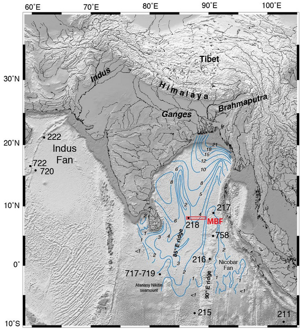
Blue lines are thickness of sediment in the Bengal Fan. Image Source.

Blue lines are thickness of sediment in the Bengal Fan. Image Source: IODP Red box is location of this year’s drilling.

This is no thin layer either. In places the pile of sediment is over 20 km thick. The oldest sediments are buried so deep they must now be metamorphic rocks3.

The total volume of the fan has been estimated to be4 12.5 million cubic kilometres. That’s enough sediment to cover the whole of Britain with a 100 km thick pile, or even the USA with over a kilometre5.

Assuming most of the sediment came from the Himalayas, which have an area of a million square kilometres, this implies that since the mountains were formed around 12.5 km of rock has been eroded off the top6. This makes sense – much of the High Himalaya is made of metamorphic rocks formed beneath the mountains and since exposed by erosion. 7.

Linking sea and mountain

This makes the fan a time-machine. Geologists who study the Himalayas, who want to understand its history, can use cores of sediment from the fan to understand what happened in the past. What metamorphic minerals were being washed off the mountains 20 million years ago? What age where they? Are there traces of the Monsoon (which is caused by the high Tibetan Plateau) at this time? The International Ocean Discovery Program (IODP) were drilling here earlier this year to answer exactly these questions.

The beautiful image we started with is from the boundary between land and sea, but the links between these two domains are many and important. Rocks that once sat kilometres above those now forming the modern High Himalaya now sit, shattered and decayed in the deep sea thousands of kilometres away. Erosion is focussed in the Himalaya partly due to monsoon rains, where moist air from the Indian Ocean is drawn onto the land by heating of air above the high mountains. Formation of the Indian Ocean crust pushed the Indian continent away from its location next to Africa to smash into Asia and form the mountains in the first place.

One day the plates will rearrange themselves and the Indian ocean will be destroyed and some of these rocks will once again find themselves on land, perhaps high in a mountain range waiting to go on another incredible journey back into the deep sea.

A new paradigm for Barrovian metamorphism?

George Barrow

George Barrow (image via BGS)

The phrase ‘new paradigm’ is a little shop-worn but it still catches the eye. To see it used in a “discussion and reply” on a dry-looking metamorphic petrology paper is really something unusual. Tracing through these articles really shows how metamorphic petrology can get to the heart of understanding what happens in the core of mountain belts.

The example of “discussion and reply”1 I’m discussing here is truly remarkable. Everyone is terribly polite and there is lots of new data and ideas contained that shed light on a classic area for the understanding of metamorphism. It also illustrates the perils and challenges of interpreting complex rocks that formed in the heart of an ancient mountain.

A paper worth discussing

The original paper, entitled ‘Metamorphic P–T and retrograde path of high-pressure Barrovian metamorphic zones near Cairn Leuchan, Caledonian orogen, Scotland’ is by Kasumaza Aoki of Tokyo, Brian Windley of Leicester and others. It studies metamorphic rocks from the Scottish Highlands. You’ve heard of Barrovian metamorphism, (if not, get thee hence), this is the type locality, where George Barrow first identified zones of rock defined by particular ‘index’ minerals.

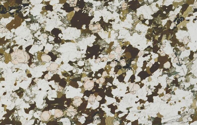
Sample of Cairn Leuchan Gneiss, collect by George Barrow himself. Garnet, plagioclase, Hornblende (brown), pyroxene (green).

Sample of Cairn Leuchan Gneiss, collected by George Barrow himself! Garnet, plagioclase, hornblende (brown), pyroxene (green). From BGS, sample S8146

Barrovian metamorphism is typical of mountain belts. It’s thought to be caused  by thrusting and stacking of rock slices within a growing mountain belt, that buries and heats up the rocks within it – causing metamorphism. This model is simple, classic and perhaps wrong. Our original paper looks at a slice of high grade rocks from the hottest, sillimanite zone. Detailed metamorphic petrology shows that “the rocks underwent high-pressure granulite facies metamorphism at P = c. 1.2–1.4 GPa and T = c. 770–800 °C followed by amphibolite facies metamorphism at P = c. 0.5–0.8 GPa and T = c. 580–700 °C”.

The later metamorphism is pretty standard for the area, but the earlier high pressure phase is unusual, suggesting these rocks were buried much deeper than previously thought. Our authors conclude that high-grade Barrovian metamorphism is retrograde, the metamorphic minerals formed as the rocks moved back towards the surface, masking an earlier deeper phase. They also suggest that the measured high-pressure metamorphism was also formed *on the way up* and that these rocks (perhaps all rocks in the area, there’s evidence nearby at Tomatin) had previously been down to eclogite or blue-schist depths.

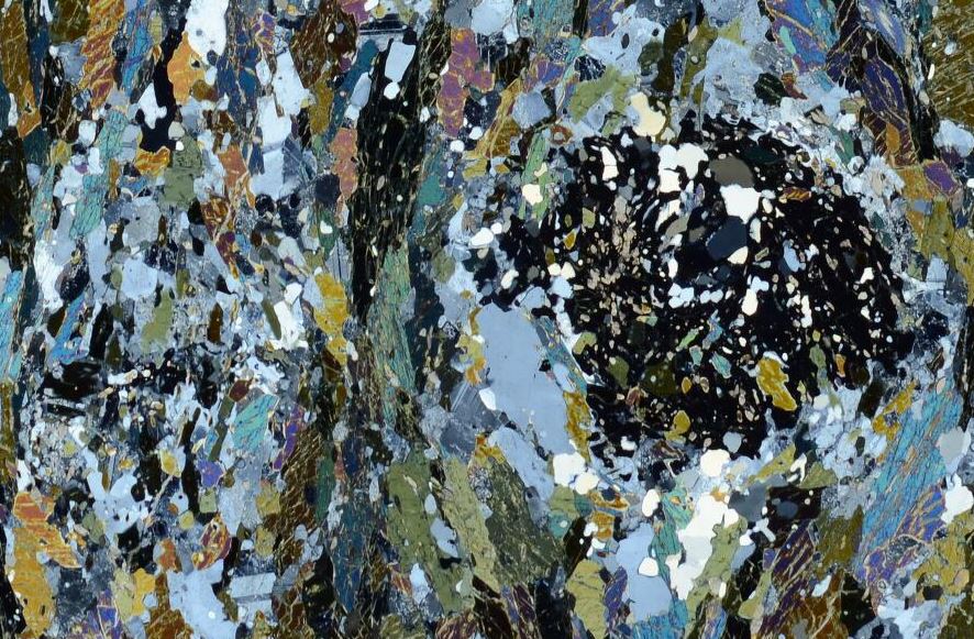
If this paper were science journalism (or course it isn’t) you could accuse it of ‘burying the lede’ – the abstract focuses purely on what they proved. The major implications of their results are made much more explicit in the Discussion by Daniel Viete and others. S98121XPL

dd

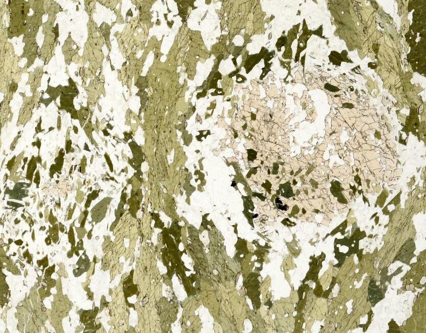
BGS sample S98121. Garnet amphibolite from Tomatin. First XPL then PPL. Relict high-pressure eclogitic garnet breaking down to plagioclase and amphibole as it moved towards the surface.

“Interesting, but maybe it’s actually….”

The discussion (by Daniel Viete, whose research I’ve written about before and others) argues against the original papers conclusions, using two lines of attack. Firstly they focus on how hard it would be to get rocks so hot, so early in the orogeny2. Other high pressure rocks in the Grampian Orogeny are much colder (e.g. blueschists in Clew Bay, Ireland). From dating, we know that the Scottish rocks were metamorphosed relatively quickly (18 million years or less). Indeed Viete has already written about the difficulty of getting rocks in this area hot enough, quick enough. This was for the well known temperatures. The problem is even greater for Aoki’s earlier deeper and hotter phase. Listing all the ways these rocks could have been heated up (mantle melts, radioactive heating, mechanical heating, already hot from rifting) they conclude that the early measured temperatures are not possible.

Secondly they describe the local geology in terms of networks of long-lived shear zones, that interleave Dalradian sediments with older basement rocks. They also provide a date of 1 billion years (much than the Ordovician age of Barrovian metamorphism) from the Cowhythe Gneiss at Portsoy, a nearby patch of high grade rocks. In conclusion, the early high-pressure metamorphism that Aoki and others describes is from an entirely different orogeny and found only in odd slices of older rock.

S94156APPL

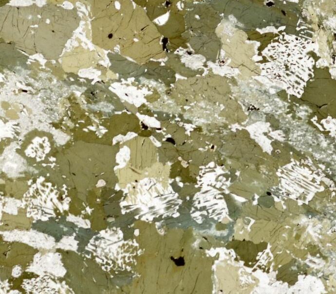
BGS sample S94156.  Garnet amphibolite from Tomatin. Intergrowths of plagioclase and amphibole – formed by decompression of an eclogite?

“With respect, no it’s not. Plus we’ve got a brand new paradigm!”

In their reply, Aoki and others defend their conclusions. Their rocks are not basement and are totally different from the Cowhythe Gneiss. Plus, old ages can often be ‘inherited’ – dated zircons may contain old ages since the crystal was a ‘detrital’ grain within the sediment that was later metamorphosed. They then turn to their explanation for their results. Acknowledging that “a reply to a comment is not the correct place to propose an entirely new paradigm for such a classic orogen” they nevertheless provide a brief overview, promising to “present our model more fully in a future publication“.

They start with the well-known enigma of how to provide the heat for Barrovian metamorphism. Modelling suggests that stacking rocks and waiting for them to heat up (the classic England & Houseman model) actually takes 50 million years. Viete has previously proposed the heat came in via advection via hot fluids. Aoki’s model proposes “the extrusion of a major wedge of hot deep eclogite which was exhumed up a subduction channel several tens of kilometres thick“.

Wow.

What they are proposing is that hot rocks within  the subduction zone, perhaps 40 km below the slowly heating orogenic wedge, broke free and was squeezed up into it, heating the wedge and causing rapid Barrovian metamorphism. This would be an extremely dramatic thing and is a radical departure from existing models for this orogeny, which is itself the ‘type locality’ for all instances of Barrovian metamorphism. Aoki refer to one earlier paper by a group from Cambridge that propose a similar mechanism for the Alps. The Alpine eclogite wedge is still clearly eclogite forming a discrete unit within other nappes. It’s not (yet) clear how Aoki’s traces of earlier high pressure minerals in an relatively homogenous Dalradian correspond to this.

What does it all mean?

For what it’s worth, I’m a little sceptical – my headline follows Betteridge’s Law – but we’ll have to wait for the paper that properly presents the new model before we can judge.

One thing that strikes me is how much Wheeler’s paper on the importance of stress throws doubt on this work. Tales of packages of rock squeezing 10s of kilometres up into an orogeny puts a lot of weight on the traces of high pressure metamorphism that are the main evidence. Explaining high pressures in terms of localised stress starts to seem like a much simpler explanation.

This is a fascinating series of papers3. It highlights how vital metamorphic petrology is to understanding mountain building processes. George Barrow first identified his zones over a hundred years ago and the Scottish Highlands have been intensely studied ever since, yet we still don’t fully understand how they formed.

The fact these papers are hidden behind a paywall is in stark contrast to the pictures I’ve used. All come from the British Geological Survey who have made them free to all. The depth of coverage is fabulous – I’ve been able to find images from the key localities mentioned in the papers within minutes. This illustrates the power of open data rather nicely – if only we could all find scientific papers as easily.

References

The original paper.
AOKI K., S. MARUYAMA & S. OMORI (2013). Metamorphic P–T conditions and retrograde path of high-pressure Barrovian metamorphic zones near Cairn Leuchan, Caledonian orogen, Scotland, Geological Magazine, 151 (03) 559-571. DOI: http://dx.doi.org/10.1017/s0016756813000514

The discussion and reply.
Viete D.R. & S. A. Wilde (2014). Discussion of ‘Metamorphic P–T and retrograde path of high-pressure Barrovian metamorphic zones near Cairn Leuchan, Caledonian orogen, Scotland’, Geological Magazine, 151 (04) 755-758. DOI: http://dx.doi.org/10.1017/s001675681300099x

The Alpine paper
Smye A.J., Tim J.B. Holland, Randall R. Parrish & Dan J. Condon (2011). Rapid formation and exhumation of the youngest Alpine eclogites: A thermal conundrum to Barrovian metamorphism, Earth and Planetary Science Letters, 306 (3-4) 193-204. DOI: http://dx.doi.org/10.1016/j.epsl.2011.03.037

An old paper on the Tomatin ‘eclogites’  

Metamorphic petrology: under pressure and getting stressed?

High pressure (HP) terranes are areas containing eclogites and other eclogite-facies rocks found within many mountains belts, including the Himalaya and the Alps. HP rocks were metamorphosed at extreme pressures, up to 3 or even 4 billion Pascals (or GPa. Atmospheric pressure is 0.0001 GPa). Based on the assumption that metamorphic pressure relates to depth of burial, these rocks have been to depths below the base of the crust. Explaining how to bury rocks so deeply, and then bring them back again, is a tricky problem.

Two parallel threads of research are challenging the assumption that high metamorphic pressures relate simply to depth of burial. Both seek to show that metamorphic reactions, and the patterns of minerals that they form, are also influenced by the squeezing and squashing rocks receive as they flow deep within the earth.

Alps 025

High pressure rocks looking moody and gorgeous. Photo of the Internal zones of the Alps from John Wheeler.

A little theory (please, don’t get stressed)

Metamorphic petrology is the art and Science of calculating the conditions under which metamorphic minerals form – I’ve written extensively about it already1. It has its basis in an understanding of the thermodynamics of the reactions that form minerals, which depend (among other things) on the temperature and pressure at the time. The lithostatic pressure that affected the rock is assumed to be caused by the weight of the column of rock overhead, following Pascal’s law2. With some assumptions as to the density of that rock, pressure can be converted into depth.

Earth scientists who study the structure of deeply buried rocks look instead at the patterns that the minerals form: fabrics, lineations, folds and the like. They have a different way of looking at the way rocks are squashed. Theories of rock deformation talk about stress, often visualised as arrows in 3 dimensions. If the stress is isotropic – equal in all three dimensions – then it is conceptually the same as lithostatic pressure. In contrast, differential stress is where the arrows are different sizes. Differential stress drives deformation – the rocks change shape.

Time for an analogy. Lithostatic pressure is like water pressure. Deep hot rocks flow like a fluid (slowly) and so the stress is equal in all directions. Rocks keep the same shape, but are put under tremendous pressure. It’s the same as putting a styrofoam cup into deep water.

4279612391_a075b4de30_o

Sytrofoam cup crushed at 600m ocean depth. Image from Gina Trapani under Creative Commons.

Differential stress is like putting the cup between the grabbers of the submersible. Squeezing in only one direction will change the shape of the cup.

Now we’re ready to look at the two challenges to the depth-pressure connection.

Challenge 1 – High levels of differential stress exist in the crust

Metamorphic petrologists who argue that high pressures are caused by deep burial believe that the effects of differential stress are unimportant. These rocks are usually extremely deformed, but they were hot and soft – by flowing easily they prevented high differential stresses from building up. In a similar way, as every toddler learns, you can’t squeeze jelly hard with your hands, because it just flows out of your fist.

Some scientists, with an interest in the European Alps, disagree. Neil Mancktelow argues that the effects of differential stress (he uses the basically equivalent similar term ‘tectonic overpressure’3 ) can be dramatic. Mathematical modelling of conditions within a confined channel (like a subduction zone) gives ‘overpressure’ of “perhaps even a few GPa”. Rocks that formed under these conditions would yield high pressure minerals but may not have been buried very deep.

At this years EGU meeting Stefan Markus Schmalholz, Yuri Podladchikov, and Sergei Medvedev used computer modelling of the Alpine orogeny, and other arguments to suggest that Alpine high-pressure eclogites need not have been deeply buried, but instead their distinctive minerals formed under conditions of tectonic overpressure.

image006

Folded layers from eclogite facies rocks in Norway. Photo from John Wheeler

Challenge 2 – John Wheeler’s recent paper in Geology

Computer models are extremely useful, but only as good as the assumptions made in them. Alone they will always have their critics. John Wheeler, a professor at Liverpool University has fingers in many pies: metamorphism;  structural geology; field-based studies; laboratory work… He takes a different approach to also puts the assumption that we can apply Pascal’s law under intense pressure 4.

In a recent open source paper in Geology he combines 2 pieces of theory. The first is from thermodynamics as used in metamorphic petrology. The second is an equation relating stress to the phenomena of pressure solution (that can form cleavage in slaty rocks).  Both are concerned with the movement of atoms to grow new minerals and neither is controversial. He converts both into terms of chemical potential and combines them to link differential stress to standard metamorphic reactions.

Applying uncontroversial values for differential stress (e.g. 50 MPa, or 1/40th of the levels Mancktelow proposes) to a standard metamorphic reaction he shows that they shift by up to 500MPa – equivalent to 15km of lithostatic pressure.

This is an extremely dramatic result from a provocative paper, as John Wheeler himself acknowledges. Metamorphic rocks are almost always deformed, sometimes dramatically so. If both approaches are correct, then putting differential stresses of Manckletow levels into John Wheeler’s equations suggests any estimates of depth of metamorphism are open to challenge. Maybe eclogites never left the crust after all?

metagabbro deformed and recrystallizing to new minerals at the same time (from Alps).

Metagabbro deformed and recrystallizing to new minerals at the same time (sample from Alps image from John Wheeler).

Where are we now?

John Wheeler  expects some  “turbulent interactions in the next few years”.  I’m sure there are  metamorphic petrologists writing their replies to his paper right now. But assuming they can’t find some fundamental flaw he hasn’t spotted (extremely unlikely, I’d say), metamorphic petrology is facing a very big challenge.

This seems like bad news. Much work on metamorphic petrology is put to work refining tectonic models by building P-T-t paths that track metamorphic rocks as they are buried and return to the surface. The error bars on these estimates were big enough already – now a entire literature of estimates that ignore differential stress are thrown into question.

But let’s think positively. Might there be ways to disentangle the effects of lithostatic pressure and differential stress? Might there be ways to get even more information out of deformed metamorphic rocks? John Wheeler certainly thinks so and he aims to get there by integrating detailed studies of rock samples with laboratory experiments.

Big advances in Science often give us new ways to understand evidence that previously didn’t make sense. Studies of metamorphism from the classic locality of the Scottish Highlands (e.g. Viete et al 2011) have noted that the highest grades of metamorphism occur within shear zones. They tried to explain this in terms of the flow of hot fluids, but maybe the answer is simpler: stressing rocks really does cause them to grow different suites of metamorphic minerals.

References:

Mancktelow N.S. (2008). Tectonic pressure: Theoretical concepts and modelled examples, Lithos, 103 (1-2) 149-177. DOI: http://dx.doi.org/10.1016/j.lithos.2007.09.013

Wheeler J. (2014). Dramatic effects of stress on metamorphic reactions, Geology, DOI: http://dx.doi.org/10.1130/g35718.1

Viete D.R., G. S. Lister & I. R. Stenhouse (2011). The nature and origin of the Barrovian metamorphism, Scotland: diffusion length scales in garnet and inferred thermal time scales, Journal of the Geological Society, 168 (1) 115-132. DOI: http://dx.doi.org/10.1144/0016-76492009-087

The Himalaya: mountains made from mountains

Good building stones get reused. Sometimes the only traces of very old buildings are their stones, built into more modern ones. It’s the same with rocks and mountain belts. Stone that now forms parts of the Himalaya was once part of a now-vanished mountain range.

The Himalaya were formed by the collision between the Indian and Asian plates. For 50 million years, the Indian plate has been pushed down into the Himalayas where it is squashed, mangled and changed by heat and pressure. Working out the details of this process of mountain building has taken decades of careful study. Modern isotopic techniques are now so powerful that researchers studying Himalayan rocks can peer through beyond the effects of the recent mountain building to see traces of older events.

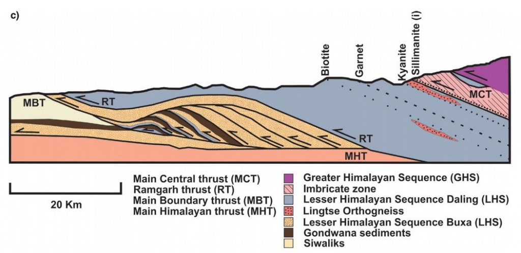
A recent open access paper by Catherine Mottram, Tom Argles and others looks at rocks in the Sikkim Himalaya, around the Main Central Thrust (MCT). As you can guess from the name (and the Use Of Capitals) this is an important structure; it can be traced over 1000km across the Himalaya and separates two distinct packages of rock known as the Lesser and Greater Himalayan Series.

Figure 2c. Cross section of MCT in the Sikkim Himalaya

Figure 2c. Cross section of MCT in the Sikkim Himalaya

As the rocks of the Indian plate were stuffed into the moutain belt, much of the movement of rock was along near-flat faults, known as thrusts. These stack up layers of rock, shortening and thickening the crust. Thrusts near the surface may be a single fault plane, but at greater depths rocks flow rather than snap and a thick thrust zone of deformed rocks is formed. This makes drawing a line on a map and calling it the Main Central Thrust rather difficult. Should the line be placed where the rock types change, or where they are most deformed, or where there is a break in metamorphism? Each approach has its advocates.

Our authors took an isotopic approach, measuring Neodymium isotopes for the whole rock and Uranium-Lead in useful crystals called Zircon. Their analysis shows that the two packages of rock separated by the MCT can be distinguished using isotopes. The actual boundary is not sharp: they prove interlayering of the two rock packages within the thrust zone, rather than a single boundary. This is not surprising given that thrusting is a gradual process and thrust surfaces are not flat.  Deformation seems to have started at the boundary between the Lesser and Greater Himalaya and gradually moved down over time.

The patterns of isotope measurements that can be used to distinguish between the Greater and Lesser Himalayan Series also tell us about what happened before India met Asia.

The zircons whose isotopes were measured are of two types, detrital and igneous. The first are grains that were eroded from old rocks and settled into a sedimentary basin. The second crystallised from molten rock: their ages record significant events. Together these sets of dates give a view of a long and complicated pre-Himalayan history.

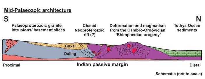
Our authors attempt to reconstruct the leading edge of the Indian plate, as it might have looked before it crashed into Asia.

Figure 10.

Figure 10. “Schematic illustration showing the pre-Himalayan architecture of the Sikkim rocks, during the mid-Palaeozoic. The Lesser Himalayan Sequence lithologies were once separated from the Greater Himalayan Sequence rocks by a Neoproterozoic rift. The Bhimpedian orogeny was responsible for closing the rift and thickened the Greater Himalayan Sequence, causing metamorphism and intrusion of granites. The failed closed rift may represent a weak structure later exploited by the Main Central Thrust. Lithologies are the same as in the legend in Figures 1 and 2.”

The Greater Himalayan Sequence had already been heated and deformed in the roots of a mountain belt long before the Himalayas existed. This a relatively common situation. Polyorogenic rocks such as these1 need to be treated with care, otherwise we might mix up events separated by millions of years. A single garnet crystal may contain different areas that formed in totally separate mountain building events

One of the detrital zircon grains dated in this study was 3,600,000,000 years old. We can only guess how many cycles of erosion and burial, how many splittings and couplings of continents this mineral has ‘seen’. As it was buried and heated once again maybe, like the bowl of petunias in The Hitchhiker’s Guide to the Galaxy it thought to itself: “Oh no, not again”.

References

Mottram C.M., Argles T.W., Harris N.B.W., Parrish R.R., Horstwood M.S.A., Warren C.J. & Gupta S. (2014). Tectonic interleaving along the Main Central Thrust, Sikkim Himalaya, Journal of the Geological Society, 171 (2) 255-268. DOI:

Argles T.W., Prince C.I., Foster G.L. & Vance D. (1999). New garnets for old? Cautionary tales from young mountain belts, Earth and Planetary Science Letters, 172 (3-4) 301-309. DOI: