Channel flow – hot rocks, big glaciers and the world’s tallest mountains

Leonardo da Vinci, famed artist and Renaissance “Renaissance Man” made some interesting remarks about Geology. When he looked at rocks in the Alps containing fossil molluscs, it was clear to his trained eye that the fossils were near identical to shells formed by creatures in the sea. That fossils are the remains of ancient creatures seems obvious now, but was a controversial idea at the time. This makes it even more impressive that he made the further step of thinking about how things that formed in the sea ended up on the top of mountains.

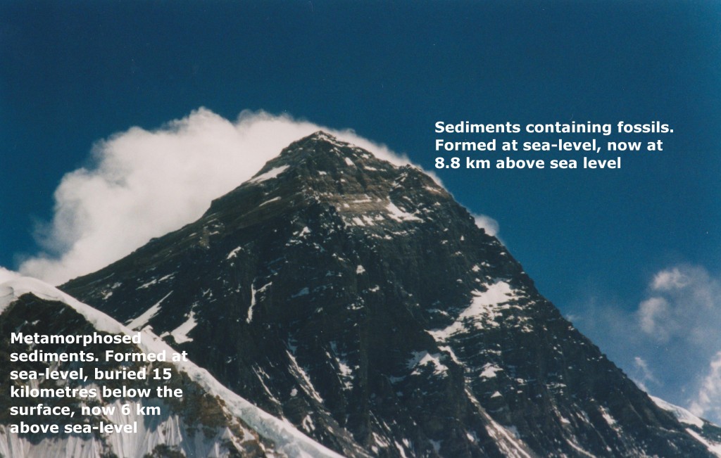
We now know that the highest peaks in the world – such as Mount Everest – are formed from ancient marine sediments. When we think about a coral – that grew safe and snug in a warm ocean that no longer exists – now lifted up 9 km to form the top of Mount Everest, the only proper response is awe. The rocks just below are even more amazing. They started in the sea  but they’ve been buried 15 kilometres below the surface, partly melted  and then drawn up to the surface by snow and rain.

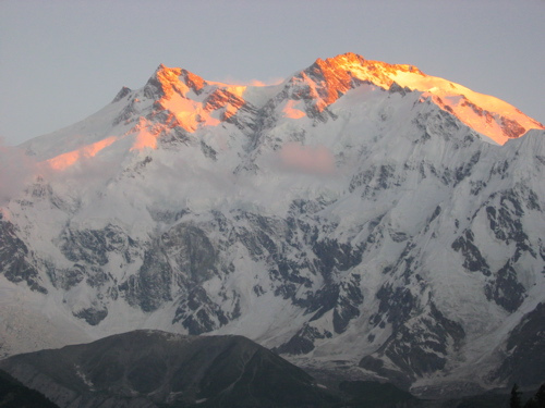
everest geology

Channel flow

If you bury the right sort of rocks in the right sort of way, they form a hot soft layer in the middle of the crust. In Asia, a soft layer is formed by the collision between the Indian and Asian plates stuff sediments (rich in heat-forming radioactive elements) down under the Tibetan Plateau. Stuck between a cold rigid layer (the upper crust) and a strong rigid layer (lithospheric mantle) this soft layer is like jelly (jam) in a  sandwich. In special places on either end of the Himalayas, this ‘jam’ squeezes to the surface via a process of extrusion in a ‘tectonic aneurysm’. Extrusion is a particular case where the middle crust ‘jam’ reaches the surface, the more general concept is called channel flow.

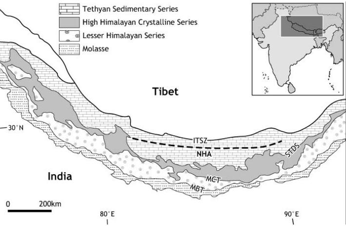
The idea of channel flow was born on the INDEPTH geophysical surveys of the Tibetan plateau, led by Doug Nelson. These suggested that there is molten rock beneath Tibet right now. At the same time, geologists across the the Himalayas were puzzling over a thick layer of metamorphic and igneous rocks (High Himalayan Crystalline Series, below) that looked as if it had been squeezed out from underneath Tibet. Channel flow puts these the two observations together – hot rocks generated beneath Tibet flowed, lubricated by molten granite, out into the high Himalaya.

tectonic map of Himalaya from Harris (2007)

In 2004, there was a conference hosted by the Geological Society of London on the subject. This brought a fantastic range of techniques to bear on the problem – geophysics, mathematical modelling and a wide range of geological studies. The ‘special publication’ based on this conference is a fantastic resource; it mixes maths-rich papers – modelling the patterns of flow that are possible, with papers full of pictures of rocks – inferring how they flowed in the past.

It’s a big thick book, but in a sentence it goes as follows. “Hot rocks in the middle crust of Tibet have formed a weak ‘channel’ that flows laterally out from areas of over-thickened crust (probably, but more research etc…)”. There are two main ways this lateral flow of ‘the jam’ can happen.

Something moving deep inside

Imagine you are standing in eastern China looking west at the Tibetan mountains – what does the future hold? Channel flow predicts that hot middle crustal rocks are flowing into the crust below your feet. Deep below, a continuous slow shuffling of atoms in lattices is changing the shape of mineral grains. With enough time, small things make big changes and solid rock can creep and flow and squeeze itself along. The ground you are standing on is ever so slowing being jacked up.  In time it will be several kilometres  higher and part of a wider Tibetan Plateau. The pandas will be gone, replaced by yaks.

This process would take millions of years longer than a human lifespan, or course and there is little solid evidence it will happen in the future. It almost certainly happened in the past though – there is evidence from river gorges in eastern Tibetan of 1.5km uplift in the last 5 million years. Channel flow is a convincing mechanism to explain how this happened.

Hot rocks, big glaciers and the world’s tallest mountain

It is quite hard to know what is going on 20km below your feet. Places where the channel reaches the surface are easier to understand as you can do Geology at the surface, studying the cooled channel rocks  (the ‘fossil jam’). A 2007 JGS review paper by Nigel Harris of Britain’s Open University (available free online) looks in particular at the rocks found on the southern edge of the Tibetan plateau – the Himalayas.

One of the key observations leading to the proposal of channel flow was the observation that metamorphic rocks of the High Himalayan Crystalline Series – “HHCS” are bounded between two fault systems. Underneath there are thrust faults, above there are extensional faults, notably the South Tibetan Detachment System – “STDS” (not STDs, oh no). The combined sense of movement of these faults is to push the metamorphic rocks out. These metamorphic rocks acted in the past as a hot flowing channel, moving from under Tibet out and along to form the world’s tallest mountains.

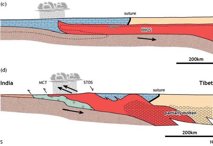
Channel flow cross section from Harris (2007)

This cross-section shows the channel flow model. Underneath the Tibetan Plateau, a hot (red) channel of soft rocks forms in the middle crust (the scale is very large so the topography is not very apparent). The stippled grey/brown material is the Indian Crust moving underneath. The Tibetan Plateau heats up in Spring and pulls moist air off the Indian Ocean up north over the Indian sub-continent to form the monsoon. Little of it gets beyond the southern edge of the plateau (cloud in the diagram) as the mountains cause precipitation. The enhanced erosion, from rain, rivers and glaciers causes exhumation (like at Nanga Parbat) and starts to draw the channel to the surface.  The lower diagram shows a slightly later stage, showing specific tectonic features. Enhanced erosion on the Himalaya front initiates a flow of material that reaches deep into the crust and 100s km laterally under the Tibetan Plateau.

This is such a beautiful idea that it ought to be true. But is it?

After extensively reviewing other models and all available evidence, Harris makes some interesting conclusions. First, “There can be little doubt that the high-grade rocks of the Himalaya were extruded southward, bounded by thrusting below and normal faults and shear zones below” so the metamorphic rocks were squeezed out as a package. Further, “evidence is emerging that is largely consistent with the hypothesis that southward extrusion during the Early to Mid-Miocene was facilitated by channel flow”, so it has happened, if only for a while 20-15 million years ago.

There is much less evidence that channel flow  in the Himalayas has been happening since. Current day zones of high exhumation and high rainfall are found further south where they are associated with brittle thrusting in lower grade rocks. This can be explained by viscous wedge models rather than by channel flow.

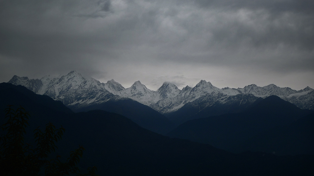
Himalayan rain from nandadevieast on Flickr

Rain and snow is amazing stuff. For a period of time it was able to influence rocks deep under the surface and 100s kms away, enticing metamorphic rocks to flow towards the surface where they can be broken into pieces and washed away back to the sea. The precipitation patterns are controlled by topography which is controlled by tectonics which is influenced by precipitation patterns… We make stories about the world, as that is the way our minds work, but a world where everything is so deeply connected can’t be reduced to our simple linear narratives.

In his paper, Nigel Harris discusses further links between precipitation and tectonics; he considers the ways in which higher rates of precipitation in the eastern Himalaya affect tectonic features. Granites associated with channel flow are  younger in (rainier) Bhutan than further west. The evidence is equivocal, but the idea that climate and tectonics have been linked for the past 20 million years and over thousands of kilometres may yet be proved right. That’s (even) more interesting than a few high-altitude fossils. If only Leonardo da Vinci were here to know it.

References and image sources

The Harris paper is available free via the Open University’s open research archive.

ResearchBlogging.org

Harris, N. (2007). Channel flow and the Himalayan-Tibetan orogen: a critical review Journal of the Geological Society, 164 (3), 511-523 DOI: 10.1144/0016-76492006-133

Godin, L., Grujic, D., Law, R., & Searle, M. (2006). Channel flow, ductile extrusion and exhumation in continental collision zones: an introduction Geological Society, London, Special Publications, 268 (1), 1-23 DOI: 10.1144/GSL.SP.2006.268.01.01

Everest picture my own, diagrams from Harris (2007) with permission of author, rainy Himalayan picture from nandadevieast on Flickr under Creative Commons.

Hot rocks, big rivers and the world’s tallest mountain face

In areas of active mountain-building the middle crust can get hot and weak, like a soft jam/jelly filling in a sandwich.  These squishy rocks are hidden from us by the cold rigid upper crust, so we wouldn’t expect to see them reach the surface, would we? Well, what happens if you overfill a sandwich and there’s a break in the upper layer? Nanga Parbat in the Karakoram Himalaya tells us what.

Nanga Parbat Rakhiot Face

Nanga Parbat is one of only 14 mountains over 8,000m in height. It’s summit is a mere 25km from the Indus, a major river flowing off the Tibetan Plateau and then along the length of Pakistan. The mountain face between the two (the Rakhiot Face, above) is often called the world’s highest as there is a drop of 7,000m, from peak to river. Nanga Parbat sits at the Western syntaxis of the Himalaya, this is the point where the structural grain of the Himalaya changes from East-West to North-South. It corresponds roughly to the corner of the Indian plate (buried somewhere below), where the plate boundary swings around.

Nanga Parbat contains granites at the surface that cooled only a million years ago. Not lava but granite that was intruded at depth and yet is now at the surface. A active major thrust puts gneisses on top of river gravels. It’s estimated that 25km of crust has been eroded away in the last 10 million years (or 12-15km over the last 3Ma, take your pick).

A hard rain falling

In order to remove 25km of crust, you need a lot of erosion. That sort of erosion requires high rainfall and a major river to take all the bits away. Both of these things are present at Nanga Parbat. What is mind-expanding is the idea that the erosion and the tectonics are linked. 

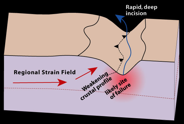
The “tectonic aneurysm” model (defined in Zeitler et. al 2001) suggests that the tectonics of the area are caused by the high rainfall and presence of the Indus river valley. Consider a river valley cutting deep into a mountainous area – it’s made a kilometres deep hole in the crust and this weakens the rocks below and either side of it.

Tectonic aneurysm initial

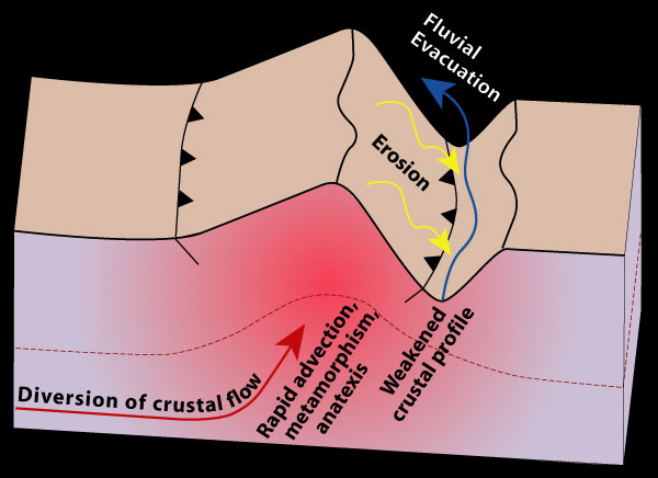
To state the obvious, remove rock from the surface and the material below moves closer to the surface. This does two interesting things – firstly the reduction in pressure makes brittle rocks weaker. Secondly, the valley will change the thermal structure of the crust. Cutting a hole into the crust will bring hotter rocks closer to the surface (because the surface is lower). Then if the rocks beneath the valley start moving up (a process called advection) then they may move up so fast that they can’t cool down on the way. There’s more. Releasing pressure in very hot rocks (decompression) can trigger melting and granite production. The presence of melt reduces the strength of the crust by an order of magnitude. This means that the crustal flow will become easier as the rocks become weaker.

tectonic aneurysm

Erosion causes uplift which causes crustal flow which causes more uplift which causes more erosion which….. This positive feedback loop turns the initial weakness into a much bigger structure that affects the entire crust. The term ‘tectonic aneurysm’ refers to a medical condition where a weakness in an artery wall can cause serious medical problems as it gets bigger. My analogy of the overfilled sandwich with a cut in the top is more cheerful, but ‘tectonic aneurysm’ sounds much more sciency.

Egg or chicken?

The tectonic aneurysm model has also been applied to the Eastern syntaxis, at Namche Barwa in Tibet, where the Tsangpo river forms a deep gorge. These syntaxes are tectonic features, related to the corners of the Indian indentor, yet the aneurysm model regards a river gorge as thing that initiates extrusion. Why is there a connection between the two?

For me this is the most satisfying part of the model – the rivers flow across the syntaxes because of the geometry of the mountains – tectonics controls the location of the rivers which in turn influences the tectonics. Processes that affect the surface and those involving the entire crust are intertwined in a dance that lasts millions of years.

Consider the growth of the Himalayas. Rivers that used to drain off proto-Tibet into the Tethys ocean are now blocked by a mountain range, where India is pushing into Asia. These rivers start to flow parallel to and behind the mountains. Over time syntaxes develop and news rivers start to cut into them. Eventually these new rivers reach the old mountain-parallel ones and ‘capture’ them. The precipitation that has been stuck to the North of the Himalayas can now get through and the major river systems of the Indus and the Tsangpo-Bhramaputra can finally reach the Indian Ocean. At the ‘knick-point’ where these rivers drop sharply in altitude major gorges are formed. These ‘cut the sandwich’ and allow the weak hot middle crust to extrude out to the surface, forming some of the most fantastic scenery on earth.

The idea that patterns of erosion affect tectonics is a lovely illustration of the interconnectedness of the geosciences and is a current topic. A  very recent paper in GSA Today by Paul Kapp and co-workers looks at wind erosion in the North of Tibet. They show significant rates of erosion and speculate a link with the (small-scale) tectonics of the area. It seems you don’t need big rivers (or indeed water) for the atmosphere to influence the way rocks deform.

The processes of crustal thickening that created the hot middle crust now extruding to the surface at Nanga Parbat affects all of Tibet. What happens to this soft material where it can’t reach the surface? Also are the syntaxes the only places the sandwich has leaked? Interesting questions. Someone should write a blog-post about them…

This post is part of my journey into the geology of mountains.

Further reading

ResearchBlogging.orgAll of the papers listed here are publicly available right now. Click on the links and you get the entire paper no matter who you are. There are links in the text above, but here’s a list of the good stuff.

The good folk of the Geological Society of America make GSA Today available to all.

The GSA Today paper Zeitler et. al (Erosion, Himalayan Geodynamics, and the Geomorphology of Metamorphism) is the place to start for the tectonic aneurysm model.

Peter K. Zeitler, Anne S. Meltzer, Peter O. Koons, David Craw, Bernard Hallet, C. Page Chamberlain, William S.F. Kidd, Stephen K. Park, Leonardo Seeber, Michael Bishop, & John Shroder (2001). Erosion, Himalayan Geodynamics, and the Geomorphology of Metamorphism GSA Today

There is also a great set of papers on the Lehigh University website.

The  Kapp et. al paper is in GSA Today, link to html version if you didn’t like PDF link above.  DOI: 10.1130/GSATG99A.1

Kapp, P., Pelletier, J., Rohrmann, A., Heermance, R., Russell, J., & Ding, L. (2011). Wind erosion in the Qaidam basin, central Asia: Implications for tectonics, paleoclimate, and the source of the Loess Plateau GSA Today, 21 (4), 4-10 DOI: 10.1130/GSATG99A.1

For more information on Nanga Parbat geology, the 2006 paper from Jones et al.  gives a good overview, plus a taster of what I’m writing about next.

Picture of Rakhiot Face from sunbeer on Flickr under Creative Commons
Diagrams from Lehigh University ‘indentor corners’ project pages, with permission.

Lovely Ladakhi landslides

Time for a post with an emphasis on photos. There’s more context here, but let’s get on with admiring the view.

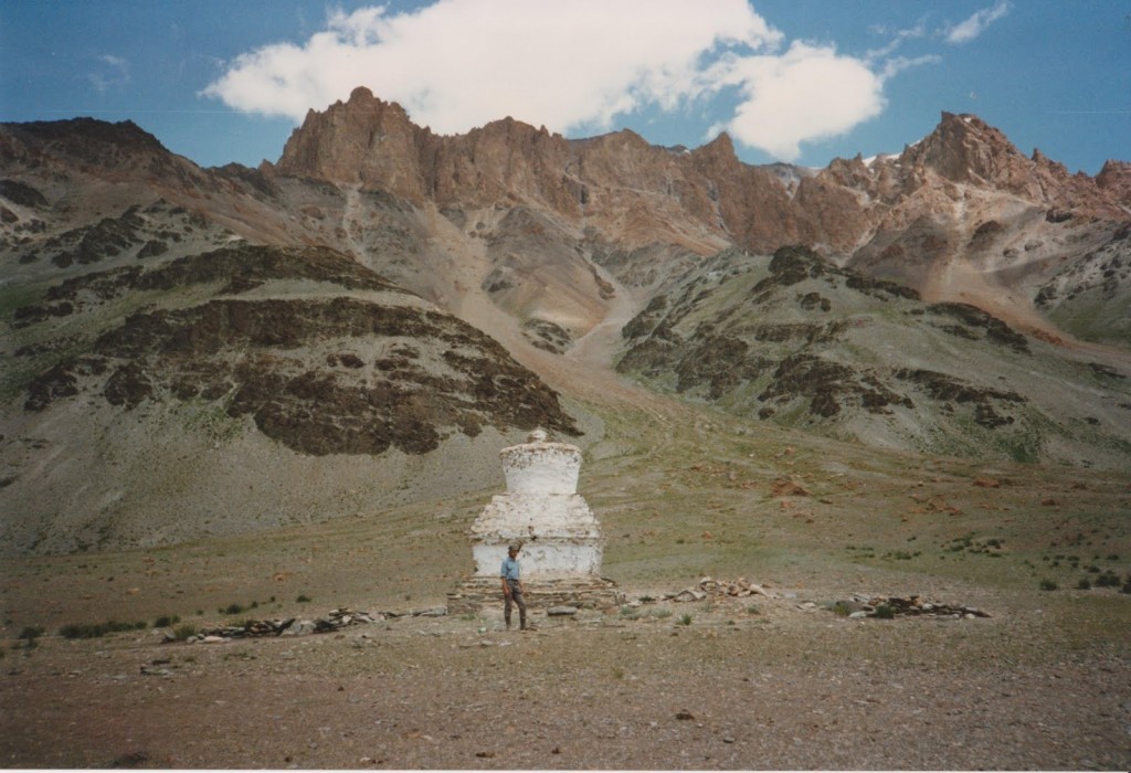
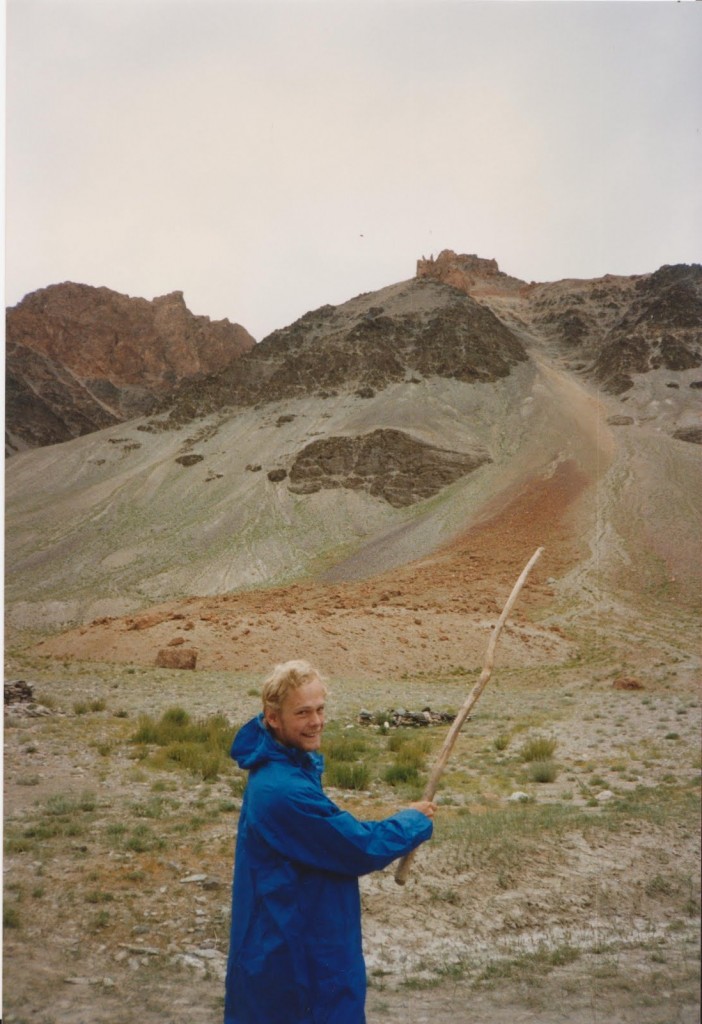
Landslide in Ladakh

That’s me, standing in front of chorten (Tibetan Buddhist religious structure). The rather pretty cliffs are Tethyan sediments, now a long way from the sea. Note that the red layers are above the green, yet there are big red blocks sitting quite below the green cliffs. The blocks suggest there has been a big landslide at some point, but no doubt fluvial processes also move material down.

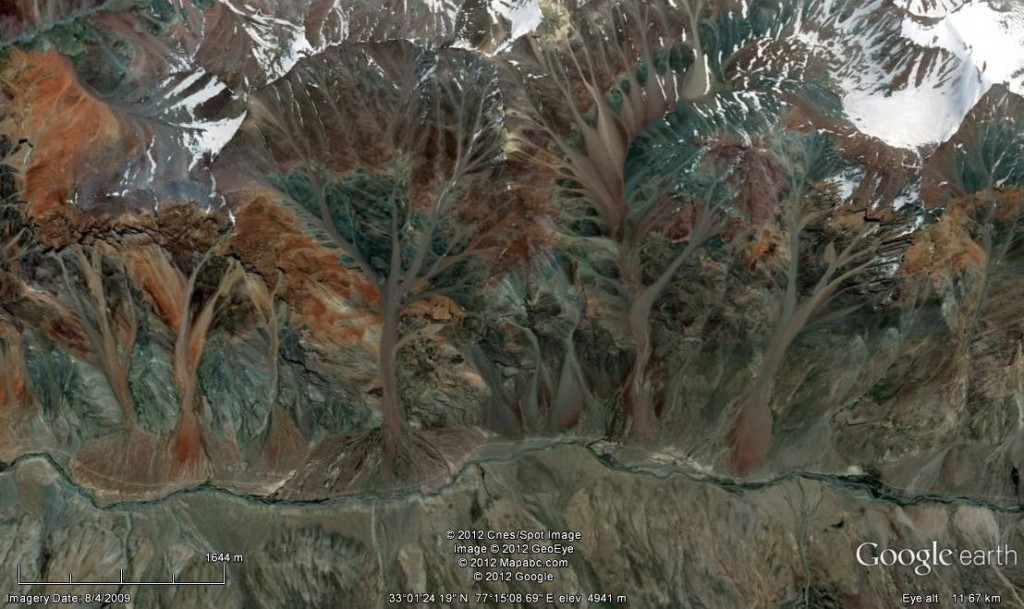
A Google Earth image shows that this is a common pattern along the river valley. Most of the big ‘streams’ of material that reach the valley floor are red, even though the green outcrops are nearer.

Here’s one last image.

beautiful landslide Ladakh

Here, my glamorous assistant points out what is unmistakeably a landslide. The link between the scar on the red cliffs and the big pile of boulders is very clear indeed.

Building models about building mountains

How do mountains form? It’s just thrusts, right? Compression causes thrust faulting which piles up layers and layers of rock. This causes Barrovian metamorphism and makes mountains. Simple, no?

No.

Thrusting is important, of course, but as always real rocks are more complicated. For example, across the whole of the Himalayan chain, coincident with the highest peaks, is a structure called the South Tibetan Detachment system. It has a normal sense of shear, so it moves in the opposite sense to a thrust. Normal faults are associated with extension, not compression. To find something like this in the heart of a mountain belt caused by two plates colliding is extremely counter-intuitive.

So, a simple explanation (“its all thrusting”) is woefully inadequate. What more sophisticated models are there and how do they explain the South Tibetan Detachment?

Critical taper theory is a model that was originally developed for accretionary wedges.

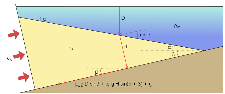
Image from Wikipedia

I like to think of it in terms of a bulldozer pushing a pile of sand up a slope. The bulldozer (e.g. Japan) is scraping sand off the floor (Pacific plate). The sand deforms into a wedge, and reaches a stable shape with a particular angle between the slope and the surface of the wedge – the critical taper. This angle is controlled by the balance between movement of the sand on the floor (the ‘basal décollement’ at the top of the oceanic plate) and deformation within the wedge itself.

The wedge is a dynamic system. If something changes (like material being eroded off the top) then the wedge will deform internally until the critical taper is reached.

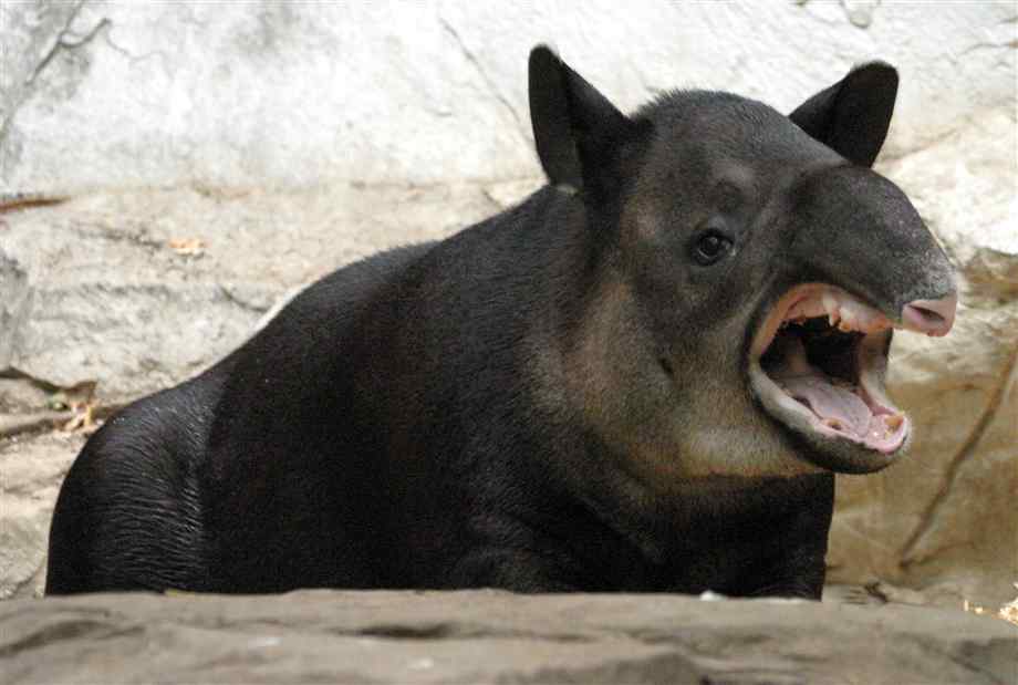
“Call this a pun? Fool” – a critical tapir.

Critical taper theory works well for accretionary wedges and has been has been modified and applied to mountains, usually using the name of orogenic wedge. Talking about the Himalayas once more, there is a structure that acts like a basal décollement called the Main Frontal Thrust. This is a feature found in many mountains belts so the concept of an orogenic wedge is a useful one.

There are many papers on this subject, but a classic of the genre is John Platt’s 1986 paper “Dynamics of wedges and uplift of high-pressure rocks” (available to us all via the man himself). It extends critical taper concepts to mountain belts such as the Alps or the Franciscan complex in California and addresses the more complex rheology of orogenic wedges (they are made up of viscous metamorphic rocks, not just cold rigid sediments). Its purpose is to explain how high-pressure rocks come to be at the surface within these wedges.

An orogenic wedge will thicken by thrusting, until it reaches its a stable geometry. If new material is added at the front of the wedge, then the wedge will shorten internally to regain a stable geometry. If new material is added underneath, to thicken the wedge, then it will extend internally. This extension within the wedge provides a mechanism to exhume high pressure rocks, to bring them to the surface via extension, even within a compressional orogen. Look at the John Platt paper for more explanation and some nice diagrams.

This is a neat trick and gives us a way to explain the South Tibetan Detachment system. The Himalayas are made-up of weak hot rocks piled up in a wedge between Tibet and the Main Frontal Thrust. They want to collapse down again, but they are kept up by the continuous movement of the Indian plate. This delicate balance has been disturbed in the past, meaning that there has been extension within the wedge, forming our normal faults. Problem solved?

For the sake of this post, perhaps yes, but I’ll leave you with a cliff-hanger. Extensional movement on the South Tibetan Detachment can in places be shown to the happening at the same time as thrusting structurally below. Wedge dynamics can’t explain this, it can only explain  thrusting and extension at different times (when the wedge is too thin or too thick). Also think of the geometry of this. If you have an extensional fault above a thrust then the material in between is being squeezed out, like a soft filling in squashed sandwich. What fresh madness is this?

This post is part of my journey into the geology of mountains.

Image of tapir from http://www.northrup.org/photos/bairds-tapir/