The Himalayan mountains: flow and fracture

Earth science departments are home to three styles of working, each of which tries to answer similar questions, but from very different perspectives. First we have the field geologists. Armed with field gear and a hammer, they gather data from actual rocks in the form of photos, diagrams and above all maps. Next we have those who live in the lab studying rock samples using mysterious machines to gain startling insights. Finally those who seek to recreate the world in a computer, building models to understand the underlying equations that can explain how the earth works.

In some departments the very different cultures and mental models that these approaches require can lead to conflict. But the best science is done when they are combined, in a department, research group or even a single brain. A recent paper by lead-author Andrew Parsons weaves together different techniques to provide a coherent model of how rocks flow to build huge ranges of mountains.

Different ways to build a mountain range

The Himalayan mountain range is the best place to study how mountains form. Sixty million years ago the Tethys ocean sat between the Indian plate and the Asian. Soon the Tethys oceanic crust vanished down into the mantle beneath Asia and the Indian plate collided with Asia. At the site of that collision now sits the highest mountains on earth, plus the huge and high Tibetan Plateau.

Geologically the Himalaya are long (over 2000km), thin and consistent. From Kashmir and Ladakh on the Indo-Pakistan border, through all of Nepal and further East through the Buddhist kingdom of Bhutan the same sequence of rocks is seen. Starting from the undeformed Indian Plain and walking up, we pass through the sub-Himalayan zone, through the Lesser Himalayan Sequence (LHS), the Greater Himalayan Sequence (GHS) and finally the Tethyan Himalayan Sequence (THS).

These distinctive packages of rock are separated by major faults. Sudden movements on these faults cause the major earthquakes that regularly affect the people who live in this beautiful part of the world. Early models for how the mountains formed focused on these thrust faults. We saw mountains as thick piles of slabs of rock, separated by brittle faults.
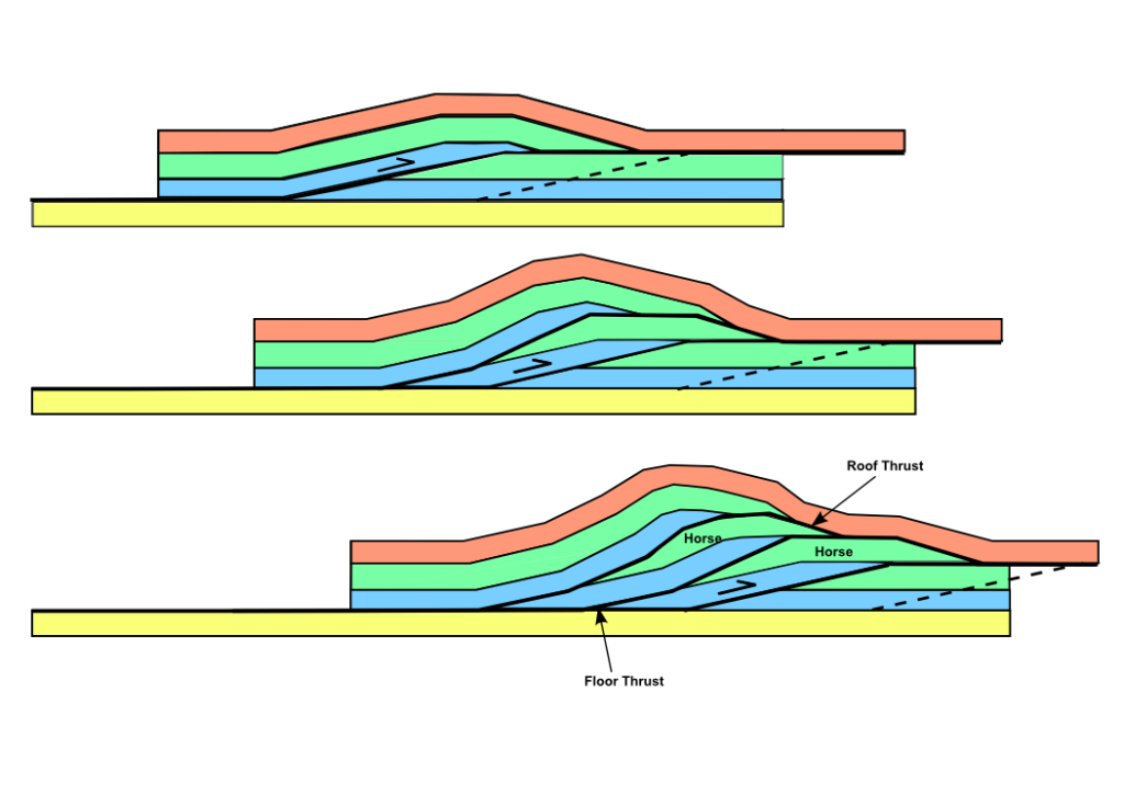
Thrust faults stack up layers of rock. Image from Wikipedia

Thrust faults stack up layers of rock. Image from Wikipedia

In these models deformation is focused on the thrust surfaces and the rocks in between are relatively strong and rigid. This is a reasonably good description of the rocks of the LHS. However studies of the GHS rocks showed them to have been strongly deformed at high temperatures. Intrusions of granite are common and appeared to form while the GHS rocks were deforming and moving rapidly towards the surface. Also the fault between the GHS and the barely deformed sediments of the THS is a normal fault, one with an opposite sense of movement to the thrust faults.
View of Mount Everest, with

View of Mount Everest, with sediments of the Tetyhan Himalayan Sequence forming the summit and metamorphic rocks of the Greater Himalayan Sequence below

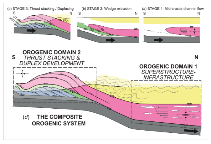
To explain these features, the concept of ‘channel flow‘ was borrowed from fluid dynamics. This describes how viscous fluids flow when trapped in a channel between two rigid surfaces (think of jam/jelly squeezed out of an overfilled sandwich). We know that hot rocks deep in the earth can flow (slowly!) even while remaining solid. The channel flow concept saw the GHS rocks as flowing out from underneath the Tibetan Plateau towards the surface, perhaps moving into the space created by rapid erosion of the high Himalayan mountains.

An alternative model for explaining the hot and deformed GHS rocks is called wedge extrusion, where deformation on thrust faults brought it to the surface, rather than channel flow.

These three models are often seen as being mutually exclusive. But what if all were true?

Going with the flow

Andrew Parsons work is based upon his PhD studies at the University of Leeds in England. He’s published a map of the Annapurna region of Nepal, covering all the main sequences of rock and so is at home in the fieldwork tradition of the Earth sciences. No doubt he has pictures of himself in field gear, looking sun-burnt and grinning in front of some amazing scenery. At the core of his prize-winning paper is hours and hours of lab-work. After wielding his hammer to collect over 100 samples in a transect across the Himalayas, he had them cut by a diamond saw into thin sections to have their secrets probed.

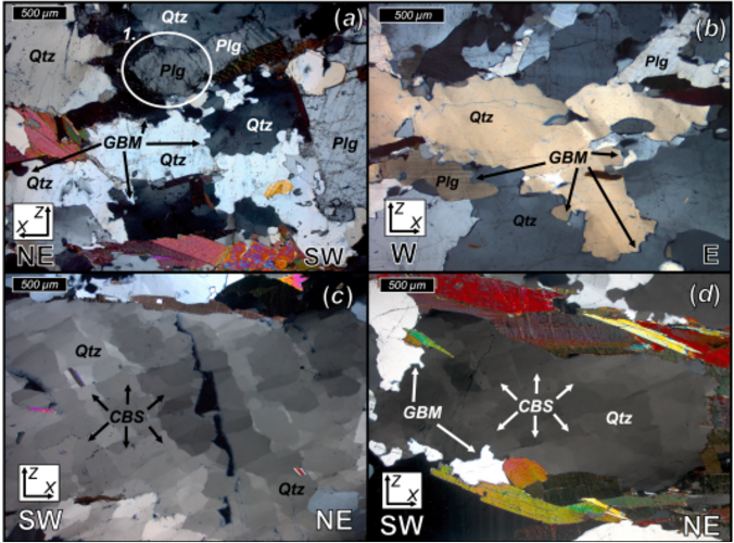
His studies used an optical microscope (to get a sense of this, check out #thinsectionThursday on Twitter) and also a scanning electron microscope. The goal was to identify precisely how the minerals in the sample were squashed.

Rocks are made of minerals and the way they flow is by deforming those minerals. We know a great deal about the many ways common rock forming minerals (like quartz, feldspar, calcite) deform. There are a range of different ways in which the minerals deform. Minerals are crystalline; the atoms within are aligned in consistent repeated patterns. Slow movement of atoms along particular slip-planes or the propagation of defects change the shape of the mineral and so deform the rock. The mineral structure is complicated and different planes of slip are favoured depending on the temperature. Careful study of subtle patterns in the minerals, plus measurement of the average orientation of the atomic structure in each grain tells a great deal.
A portion of figure 6, showing different microscope images of rock samples, with different features highlighted.

A portion of figure 6, showing different microscope images of rock samples, with different features highlighted.

For each sample, the authors were able to estimate the temperature at which the rocks were deformed. Also they got a sense of the style of deformation. Imagine a perfect sphere in a rock that is then deformed. Rocks can be flattened turning the sphere into a cow-pat or M&M shape or maybe stretched into a cigar shape. As well as this, the deforming sphere can also be rotated. A combination of field observations, thin section studies and the scanning electron microscope work together gives a view of how the rocks were squashed.

Bringing it all together

The core achievement of this award-winning paper is linking the mass of data to the predictions of the various tectonic models.  Channel flow is predicted in the GHS rocks while they were hot and rapidly flowing. The entire channel should flow and rotation only be seen at the edges. This is what the samples from the upper section of the GHS show, plus an indication that this style of deformation ended while they were still at 550°C and changed from being hot and soft to being more rigid.

At this point channel flow ceased and another mechanism, rigid wedge extrusion, came into play. Here the lower portion of the GHS was deforming at a lower temperature. As the model would predict, deformation involves a lot of rotation, consistent with the whole of this sequence of rocks acting as a broad shear zone, bringing the upper GHS rocks  closer to the surface.

The lowest temperature deformation is found in a thin zone of rocks within the lower GHS that were acting as a thrust fault, stacking up different slices of rock.

Figure 12

Figure 12

This diagram emphasises the key insight – that different ways of building up mountains can be active at the same time, within different parts of the mountain belt. The mountain building (orogenic) system is composite, made up of different parts. Studying individual mineral grains helps us understand the structure of a massive mountain range. This is because that is how it grew. Countless millions of mineral grains slowly shuffling their atomic lattices over millions of years: this is what builds mountains.

The system is still active, as India pushes into Asia. We know from geophysics that there are hot rocks under the Tibet – perhaps these are right now flowing to the surface as a channel. As the Himalayas are eroded away they will get nearer the surface and start cooling, causing different styles of deformation to come into play.

The terminology of ‘superstructure/infrastructure’ used in this diagram is taken directly from computer modelling work. Numerical models of how mountain belts might work have directly informed this work. Cold rocks near the surface can be a lot stronger than the hot rocks below. By combining computer modelling with field work and lab studies, geologists are getting a good understanding of how the Himalayan mountains formed and have evolved over time. Many places are built on the roots of ancient mountain ranges and high-quality integrated studies such as this help us understand rocks across the world.

Parsons, A. J., et al. “Thermo‐kinematic evolution of the Annapurna‐Dhaulagiri Himalaya, central Nepal: The Composite Orogenic System.” Geochemistry, Geophysics, Geosystems 17.4 (2016): 1511-1539.

Sediment and sea: from the heights to the depths

This study in blues and greys and browns, this combination of fuzziness and sharp edges, where is it?

It’s where land and ocean meet and mingle. A place where mud and silt and sand pause half way along an incredible journey that links the destruction of mountains to the creation of new land.

It’s an aerial view of the sea offshore from the Sundarbans, a vast area of tidal mangrove forest in India and Bangladesh. Sitting in the eastern elbow of the Indian subcontinent this is where the water from the Ganges and Tsangpo-Bhramaputra rivers enters the sea.

What makes the picture interesting is the dynamic shifting patterns of the sediment under the water. Water that when madly dashing down-hill had the power to carry sediment, but now it’s reached the sea it slows down and the sediment starts to pile up. Tiny clay minerals that were happily floating in suspension in fresh-water suddenly clumped together and sank in the salty sea1. The shape of the land here is caused by this process, plus the influence of the daily tides and the sinking of the ground as the sediment squashes down into itself. Fractally-frequent creeks and rivers snake their lazy way across near-flat terrain making it dangerously sensitive to changes in sea-level.

What is the sediment?

The sediment in this image came from the Himalayas. Some of came from near Mount Kailas and moved nearly 3,000km along the Tsangpo river tracing a line parallel to and north of the Himalayas. Cutting through the Himalayas at the Namche Barwa syntaxis the river cuts deep into the earth, eroding so deeply that the hot rocks beneath are flowing up to fill the hole, like jam oozing from a cut doughnut.

Map of the Yarlung-Tsangpo-Bhramaputra river. Image source.

Map of the Yarlung-Tsangpo-Bhramaputra river. Image source Wikipedia.

Often we are taught erosion as a gradual, calm almost civilised process. Not necessarily. Some of this sediment did indeed start as a small grain popped of an outcrop and rolled gently into a mountain stream. But more of it comes from boulders in glaciers scraping and scratching the rocks beneath, the resulting rock flour staining the glacial streams a milky blue. Or maybe from where the river cut a slope impossibly steep and a huge landslide smashed the rock into pieces. Or where the landslide dammed the river, until inevitably the water overtops it and a huge boulder-rolling crushing scouring flood sweeps down the valley.

Where the sediment came from

Sediment isn’t just generic stuff, it’s made of minerals, each with a character and a history of its own.

The sediment carries traces of the intense underground events that formed the mountains. Simple sand can be quartz crystals freed from ancient sandstones, born in the vanished Tethys ocean. Yet transformed in the meantime, crystals lattices rotated, grain boundaries switching and twisting as the rocks were heated and deformed.

More dramatic still is the story of the clay. Layers of silicates like illite or chlorite, packed higgley-piggledy with all manner of atoms, lazy and relaxed, suited for a soft low-pressure life on the surface. But these minerals are new, results of chemical weathering, a decline, a descent from what was once strong and pure2. Metamorphic minerals forged in the mountain’s heart: sparkling muscovite; kyanite, face lined from the pressure; hot-headed sillimanite, bushels of fibres bursting out the guts of the biotite it was feeding on.

These are strong minerals, forged under intense conditions. But under the attack of water, oxygen and sunlight they turn back into the clay the originally formed from. Some metamorphic minerals can survive longer at the surface, garnet, zircon and others form a very small part of the sediment load, but one that can tell us a great deal about where they’ve been.

Where it’s going

The sediment patterning the sea-bed in the image above has not reached the end of its journey. Sediment that joined a river perched 5 kilometers above sea-level is still nearly the same height again above the vast deep plains of the Indian Ocean.

Sediment flows downhill under water just as well as it does on land. Submarine channels are formed by turbidity currents – fast flows of sediment-filled water that travel vast distances down into the deep ocean. These undersea rivers have banks and trace sinuous patterns on the surface just like their cousins above land.

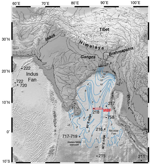
For over 20 million years, sediment flowing into the ocean from the Himalayas has formed the Bengal fan, a triangular pile of sediment that is 3000 km long, filling nearly all the sea-floor between the Indian sub-continent and south east Asia.

Blue lines are thickness of sediment in the Bengal Fan. Image Source.

Blue lines are thickness of sediment in the Bengal Fan. Image Source: IODP Red box is location of this year’s drilling.

This is no thin layer either. In places the pile of sediment is over 20 km thick. The oldest sediments are buried so deep they must now be metamorphic rocks3.

The total volume of the fan has been estimated to be4 12.5 million cubic kilometres. That’s enough sediment to cover the whole of Britain with a 100 km thick pile, or even the USA with over a kilometre5.

Assuming most of the sediment came from the Himalayas, which have an area of a million square kilometres, this implies that since the mountains were formed around 12.5 km of rock has been eroded off the top6. This makes sense – much of the High Himalaya is made of metamorphic rocks formed beneath the mountains and since exposed by erosion. 7.

Linking sea and mountain

This makes the fan a time-machine. Geologists who study the Himalayas, who want to understand its history, can use cores of sediment from the fan to understand what happened in the past. What metamorphic minerals were being washed off the mountains 20 million years ago? What age where they? Are there traces of the Monsoon (which is caused by the high Tibetan Plateau) at this time? The International Ocean Discovery Program (IODP) were drilling here earlier this year to answer exactly these questions.

The beautiful image we started with is from the boundary between land and sea, but the links between these two domains are many and important. Rocks that once sat kilometres above those now forming the modern High Himalaya now sit, shattered and decayed in the deep sea thousands of kilometres away. Erosion is focussed in the Himalaya partly due to monsoon rains, where moist air from the Indian Ocean is drawn onto the land by heating of air above the high mountains. Formation of the Indian Ocean crust pushed the Indian continent away from its location next to Africa to smash into Asia and form the mountains in the first place.

One day the plates will rearrange themselves and the Indian ocean will be destroyed and some of these rocks will once again find themselves on land, perhaps high in a mountain range waiting to go on another incredible journey back into the deep sea.

The Himalaya: mountains made from mountains

Good building stones get reused. Sometimes the only traces of very old buildings are their stones, built into more modern ones. It’s the same with rocks and mountain belts. Stone that now forms parts of the Himalaya was once part of a now-vanished mountain range.

The Himalaya were formed by the collision between the Indian and Asian plates. For 50 million years, the Indian plate has been pushed down into the Himalayas where it is squashed, mangled and changed by heat and pressure. Working out the details of this process of mountain building has taken decades of careful study. Modern isotopic techniques are now so powerful that researchers studying Himalayan rocks can peer through beyond the effects of the recent mountain building to see traces of older events.

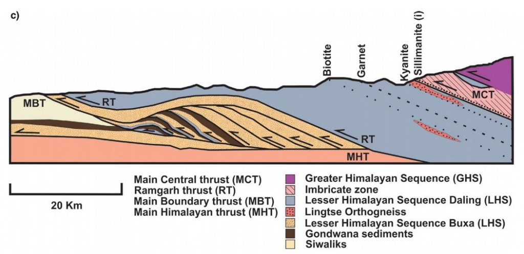
A recent open access paper by Catherine Mottram, Tom Argles and others looks at rocks in the Sikkim Himalaya, around the Main Central Thrust (MCT). As you can guess from the name (and the Use Of Capitals) this is an important structure; it can be traced over 1000km across the Himalaya and separates two distinct packages of rock known as the Lesser and Greater Himalayan Series.

Figure 2c. Cross section of MCT in the Sikkim Himalaya

Figure 2c. Cross section of MCT in the Sikkim Himalaya

As the rocks of the Indian plate were stuffed into the moutain belt, much of the movement of rock was along near-flat faults, known as thrusts. These stack up layers of rock, shortening and thickening the crust. Thrusts near the surface may be a single fault plane, but at greater depths rocks flow rather than snap and a thick thrust zone of deformed rocks is formed. This makes drawing a line on a map and calling it the Main Central Thrust rather difficult. Should the line be placed where the rock types change, or where they are most deformed, or where there is a break in metamorphism? Each approach has its advocates.

Our authors took an isotopic approach, measuring Neodymium isotopes for the whole rock and Uranium-Lead in useful crystals called Zircon. Their analysis shows that the two packages of rock separated by the MCT can be distinguished using isotopes. The actual boundary is not sharp: they prove interlayering of the two rock packages within the thrust zone, rather than a single boundary. This is not surprising given that thrusting is a gradual process and thrust surfaces are not flat.  Deformation seems to have started at the boundary between the Lesser and Greater Himalaya and gradually moved down over time.

The patterns of isotope measurements that can be used to distinguish between the Greater and Lesser Himalayan Series also tell us about what happened before India met Asia.

The zircons whose isotopes were measured are of two types, detrital and igneous. The first are grains that were eroded from old rocks and settled into a sedimentary basin. The second crystallised from molten rock: their ages record significant events. Together these sets of dates give a view of a long and complicated pre-Himalayan history.

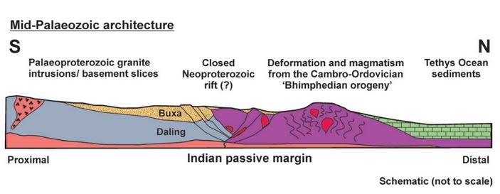
Our authors attempt to reconstruct the leading edge of the Indian plate, as it might have looked before it crashed into Asia.

Figure 10.

Figure 10. “Schematic illustration showing the pre-Himalayan architecture of the Sikkim rocks, during the mid-Palaeozoic. The Lesser Himalayan Sequence lithologies were once separated from the Greater Himalayan Sequence rocks by a Neoproterozoic rift. The Bhimpedian orogeny was responsible for closing the rift and thickened the Greater Himalayan Sequence, causing metamorphism and intrusion of granites. The failed closed rift may represent a weak structure later exploited by the Main Central Thrust. Lithologies are the same as in the legend in Figures 1 and 2.”

The Greater Himalayan Sequence had already been heated and deformed in the roots of a mountain belt long before the Himalayas existed. This a relatively common situation. Polyorogenic rocks such as these1 need to be treated with care, otherwise we might mix up events separated by millions of years. A single garnet crystal may contain different areas that formed in totally separate mountain building events

One of the detrital zircon grains dated in this study was 3,600,000,000 years old. We can only guess how many cycles of erosion and burial, how many splittings and couplings of continents this mineral has ‘seen’. As it was buried and heated once again maybe, like the bowl of petunias in The Hitchhiker’s Guide to the Galaxy it thought to itself: “Oh no, not again”.

References

Mottram C.M., Argles T.W., Harris N.B.W., Parrish R.R., Horstwood M.S.A., Warren C.J. & Gupta S. (2014). Tectonic interleaving along the Main Central Thrust, Sikkim Himalaya, Journal of the Geological Society, 171 (2) 255-268. DOI:

Argles T.W., Prince C.I., Foster G.L. & Vance D. (1999). New garnets for old? Cautionary tales from young mountain belts, Earth and Planetary Science Letters, 172 (3-4) 301-309. DOI:

The Geology of Mount Everest

This post was chosen as an Editor's Selection for ResearchBlogging.orgGrowing up, I was mildly obsessed with Mount Everest. Even now I marvel at its wonderful geology.

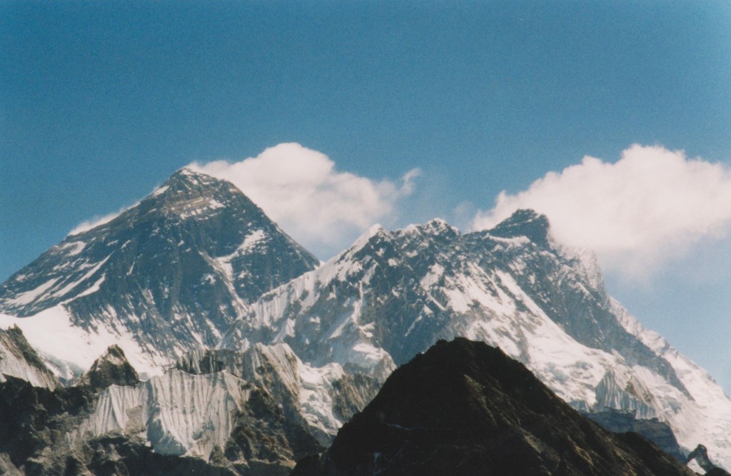
Looking at that, who can blame me?

My youthful obsession was fuelled by books of British expeditions in the 1970s climbing it by various routes with varying levels of success.  The photos were the best; an image by Doug Scott showing Everest, Lhotse and Makalu, taken by from Kangchenjunga was particularly mesmerising. <aside> Makalu (left-hand of 3 tall peaks) in particular is intriguing as it looks like it had a glacial ‘U-shaped’ valley that has now mostly fallen away in landslides. If you know more, please tell me! </aside>.  I started my teenage years wanting to climb mountains like this, but by the end of my teens this had waned. It was too apparent that many people in the early books had been killed on the mountains. Now that Everest seems full to the seams with the rich and the foolish – littered with their corpses – the glamour has worn off somewhat.

It was still a great thrill to go on a walking holiday to the Everest region, particularly as by then the geology of the area was properly understood. I shall use my pictures to illustrate the geology, as described in a 2003 paper by Mike Searle and colleagues, available on line via his Everest map website.

Let’s revisit that first picture.

Mount everest geology

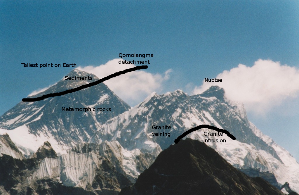
This shows the main features, north is to the left. The summit area is made of sedimentary rocks, now far from the sea. The contact with the metamorphic rocks is not an unconformity, but an extensional detachment:  a structure – here brittle fault, there shear zone- that is usually associated with thinning of the crust. The Qomolongma detachment, together with the Lhotse detachment (in my picture, hidden in the Western Cwm, the valley between Everest and Nuptse) together are part of the South Tibetan Detachment System (STDS) which can be traced along the entire Himalayan chain

The rocks labelled as metamorphic rocks are greenschist facies, but the Nuptse ridge (right hand side of picture) contains high-grade sillimanite gneisses and many granite intrusions. These are part of a package of high-grade metamorphic rocks, the High Himalaya Crystalline series that are everywhere found below the STDS. Searle and colleagues explain these rocks in terms of channel flow.  This amazing theory says that between 21 and 16 million years ago, a thick channel of soft hot rocks flowed out from under the Tibetan Plateau towards the Himalayas.

The Qomolangma detachment is part of the top of this channel. The high-grade rocks below flowed 200km south into their current position, moving at a shallow angle parallel to the top of the channel.  The driving force for all of this? The snow and rain falling on the mountains and eroding the surface.

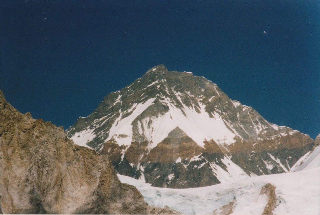
Let’s look at the rocks in more detail. Above is a picture of Changtse in Tibet, taken from near the head of the Khumbu valley in Nepal. It is looking up and north at the Qomolangma detachment. The prominent yellow band, often mentioned by mountaineers, is marble and lies just below the detachment. Above are unmetamorphosed sediments. Left in the foreground is mostly granite.

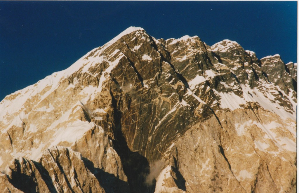
Turning to the metamorphic ‘channel’ rocks lets look at the South face of Nuptse, from a more direct angle.

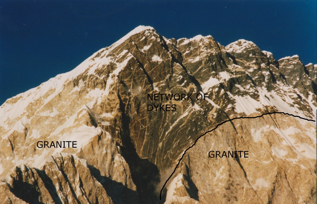
The picture is around 3 kilometres from top to bottom. The dark rocks are high-grade gneisses, that flowed 200km towards the camera. A clue as to how they did that is found in the pale areas – granite. Rocks containing melt have a much lower viscosity. The many dykes/veins in above the granite are, according to Searle, an “explosive network of dykes emanating out of the top of the Nuptse–Everest leucogranite” caused by late-stage volatile rich magma. In other words, the fluid left behind as the main intrusion cooled and solidified.

Nuptse south face geology annotated

Searle interpret the right-hand granite body as a sill that ballooned into a much thicker body. It passes under the summit of Everest and an equivalent body is found in the east Kangshung face of Everest. They speculate that the presence of this 3km thick granite body might explain the particularly high mountains.

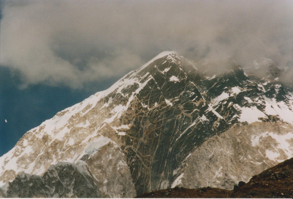
Another view there, in different light with some moody clouds.

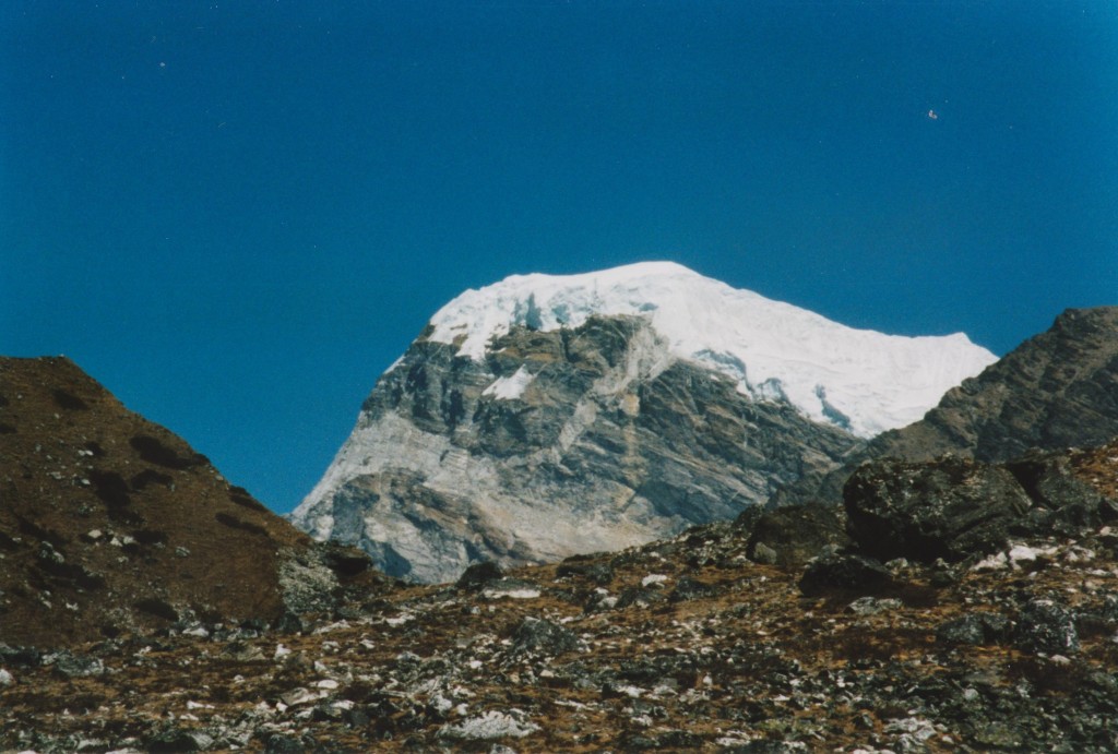
Granitic sill and feeder dyke, khumbu valley

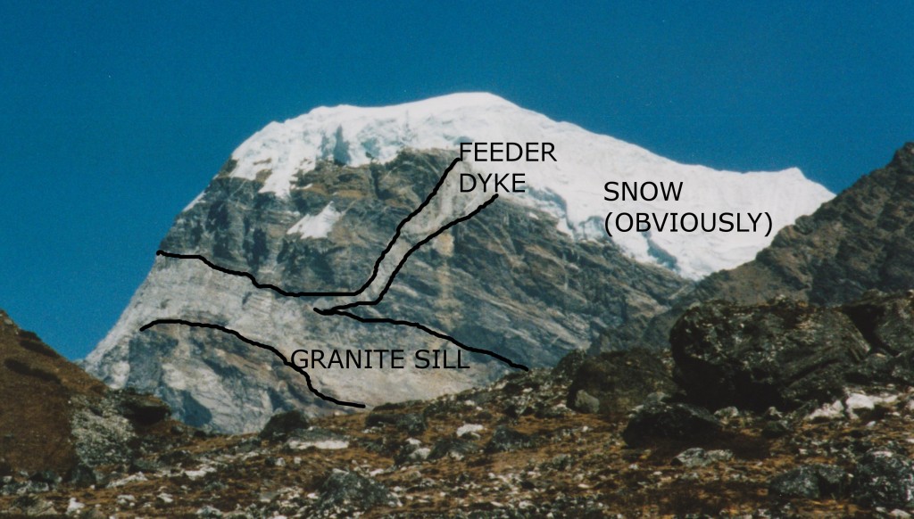
This is a view of an unnamed mountain on the side of the Khumbu valley. It shows a more typical view of the granite intrusions in the area, plus a glimpse of how it was intruded.

Annotated granite dyke-sill Everest region

Granite sills are typical of the area, but the dyke was the only one I saw. The intrusion process was of sills making space via hydraulic fracturing along bedding/foliation planes in the dark metamorphic rock. Dykes allow flow between sills.

In the 30’s and 50’s mountaineers on Everest were also explorers and they collected samples  One  geologist, Lawrence Wager, got to with 300m of the summit in 1933 and later became Professor of Geology at Oxford (my alma mater) . One paper on Everest geology (Jessup et al 2006) is a detailed study of microstructures. It involved studying Wager’s samples, plus others collected on the 1953 expedition. One was collected by Edmund Hilary only 12 metres below the (snow-covered) summit. Either just before or just after he became the first man on the Earth’s highest point, he took the time to collect a rock sample. Mount Everest and geology are closely intertwined.

References and further reading

ResearchBlogging.org
SEARLE, M., SIMPSON, R., LAW, R., PARRISH, R., & WATERS, D. (2003). The structural geometry, metamorphic and magmatic evolution of the Everest massif, High Himalaya of Nepal-South Tibet Journal of the Geological Society, 160 (3), 345-366 DOI: 10.1144/0016-764902-126

The Searle paper came out of joint research between Oxford and Virginia Tech universities. Both have websites with more gorgeous pictures. The Oxford one has a low-res version of a map made of the area and includes a copy of the Searle paper. The Virginia Tech one has pictures linked to a map.

Ron Schott has compiled a list of Gigapans from the Himalayas, including a few from the Everest region.

You can find more on the Wager / Everest connection online. If you want to see a photomicrograph of the highest rock sample ever collected, figure 6 of the Jessup et al paper is the place to go.

This post is the summit of my journey into the Geology of mountains. If you want more detail on channel flow and associated concepts, that’s the place to go.