Geomorphology is the study of the formation of landscapes, and may not seem immediately relevant to the farmyard. But heaps of wet grain and mountains of fractured rock are shaped by the same processes. It’s all just a question of scale. This post illustrates some of the similarities.
Wet wheat behaves like fractured rocks
Freshly cut wheat, piled up into heaps as it waits to be dried, is a common sight across Scottish farmyards this September. The grain will be fed through the grain drier, which blows hot air through it (like a huge, diesel-gulping, hair drier) and reduces the moisture content to less than 15%. The drying process prevents the grain from germinating or going mouldy during transport and storage.
In a good year, minimal drying is required as the sun does most of the hard work while the crop is still standing in the field. This summer has been rubbish, however. There have been only short dry windows between bouts of rain, meaning that lots of wheat had to be harvested before it could dry out naturally. It has left farmers cursing and big heaps of wheat with up to 30% moisture standing on the farms.
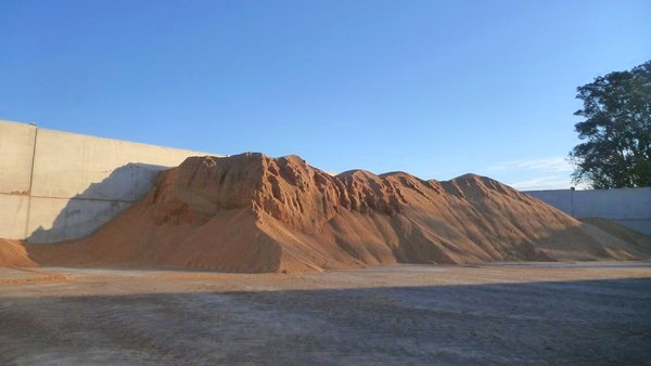
As grain is taken, bit by bit, from the heap to the drier, the geomorphological connection becomes clear. Wet wheat is slightly sticky, so the grains do not flow past each other very easily and the pile can behave as a solid whole. This effect is especially apparent if the grain has been sitting for a day or two. If vertical walls remain as grain is removed from the edge of the pile, farmers know that the grain will need a lot of drying. The moisture content is a strong control on the behaviour of the pile, and the size of walls that it can support. This is demonstrated in the picture below.

Grain heap ~3 m tall. The grain was cut from a number of different fields on different days and the moisture content varies from 24-28% on the left of the image, to 20-24% at the right. The ability to support vertical walls decreases with decreasing moisture content.
The wheat walls are not stable for long and are soon sculpted into cliffs and valleys and ‘scree slopes’ (also known as talus ramps in countries where they eat tomaytoes) of loose grains by a series of small landslides (or wheatslides?). The results are strikingly similar to real-life mountain landscapes. Given sufficient time, all the cliffs will collapse to form a pile with uniform, smooth sides. The angle at which the loose grains are stable is called the ‘angle of repose’ and is higher in the wet grain than the dry.
Beans means bedrock
The collapse of the grain heap is interesting because it demonstrates processes that take thousands of years in real mountains, but in the space of a few minutes or hours. The farmyard is like a large-scale version of an experiment published by Alex Densmore and colleagues in 1997 in the journal Science, and which is now carried out in undergraduate labs each year in order to demonstrate erosional processes. They built a perspex box with a wall that could slide up and down, and filled it with elongate, red beans, which simulated the bedrock in mountainous regions. As they lowered the sliding wall, the beans spilled out over the edge. At each stage, they weighed the beans and traced the profile of the bean surface on the transparent side of the box.
They found that the beans were not lost continuously, but fell in bursts in a series of unpredictable landslides of differing sizes. Steep slopes could develop and last for a short time, but would be swept away in bigger events. In fact, the vast majority of material (70%) was removed by just a small number (10% of the total count) of large events. Densmore and colleagues concluded that the variety in landslide size was down to the existence of regions in the pile where the beans were aligned and which behaved as coherent lumps. When they repeated the experiment using white beans (which have a more spherical shape), they found that the landslides were more regular and evenly-sized.

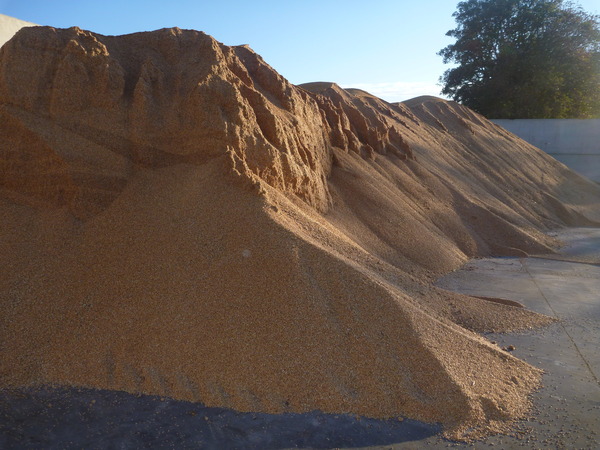
A closer view of the grain pile. Internal structure, formed when the pile was pushed up, is visible as aligned grains form light and dark bands. Collapse of the vertical walls leads to formation of 'scree slopes' of loose grains.
In real-life mountains, the sliding wall of the perspex box represents the lowering of the baselevel of a valley by erosion, perhaps by a stream or river. The red beans represent bedrock that contains a network of fractures that are much weaker than the rock itself. Such studies are important because landslides are a real danger in many parts of the world (there were a number in Nepal and India following an earthquake in the area on Sunday), and if we can understand how they work then the areas at greatest risk can be identified and avoided.
Beans versus wheat, wheat versus mountains
In the grain heap, the lowering of the baselevel is controlled by a forklift taking wheat from the foot of the slope. Instead of a gradual lowering, this happens quickly, then the grain pile has to catch up. While the grains can align as the beans did, grain moisture is a key factor in slope stability and dry grain behaves more like white beans. A few large landslides make much bigger changes than many small ones. The erosion of the walls is helped by drying of the surface by the sun, or by the wind, or by grains from above sliding down scree chutes.

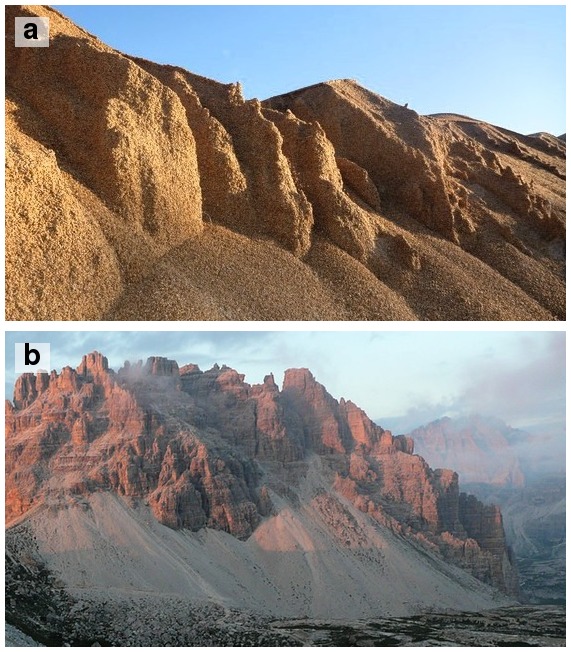
(a) Steep buttresses and scree slopes, grain pile, Fife, Scotland. (b) Steep buttresses and scree slopes, Tre Cime de Lavaredo, Dolomites, Italy.
The landscape in the Dolomite mountains of Italy bears an uncanny resemblance to the grain heap. There, the mountains are adjusting to lowering of the baselevel by glacial erosion during the last Ice Age. The rock contains different layers 20-200 cm thick, that make up a network of planes of weakness and frost, sun, wind and rain erode it away. Scree chutes run between the peaks and build up at the base.
Though these mountains are literally ‘as old as the hills’ the lessons learned from the small size, high-speed example of the grain pile gives a glimpse into their future state. The area has been designated at UNESCO World Heritage Site for its spectacular scenery. But if you want to enjoy it, you’d better hurry up. In a million years, it will be nothing but a pile of scree.

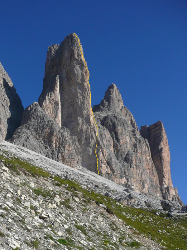
Here for a limited time only: Cima Piccola, of the Tre Cime, Dolomites, Italy. The orange line is the classic rock climb, Spigolo Giallo. As with the 'cliffs' in the grain heap, it is just a matter of time until all this is just scree.
Meanwhile, back on the farm
Fascinating though all of this is, I’m sure that most farmers would much rather see two weeks of wall-to-wall blue skies, and sun-dried grain flowing into the grain store as smoothly as water, than ponder the fate of distant mountains. Hopefully the weather will pick up in the next few days.

