Looking out for the red rocks

Author Tim Robinson spent countless hours in the west of Ireland, unearthing local Irish-language place names. Some are anchored in myth and poetry, referring to miracle-working saints or Celtic Gods. Most though are prosaic, being linked to people’s names, local plants or animals and – occasionally – geological features.

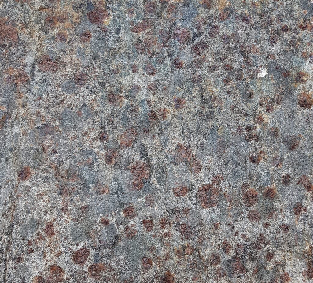
Fàire nan Clach Ruadha is one of the countless hills within Assynt’s central wilderness, just another small summit amid the craggy wastes of the Cnoc and Lochan landscape. Once I’d roughly translated it as ‘red stone lookout’, I knew I had to pay a visit. Secretly I was hoping the ‘red rocks’ would be garnet-rich, as is often the case within the Lewisian Gneiss.

The sort of red rocks I was hoping for. Garnet-rich Lewisian Gneiss from Scourie

On a perfect June day I went in search of the physical realities behind the name. Let’s start with ‘Fàire’. The online resources I’ve used translate this as ‘watch, lookout’, which implies someone once sat on the top of the hill, keeping an eye out for something. This could have been livestock: sheep or cattle. Subsistence farming practices saw animals brought into the interior during the Summer, to make use of the good grazing found here and keep them away from arable crops. Ruins out here are often Shielings, simple buildings built for Summer use only. We are not far here from some and the hill offers good all-round views of the immediate area.

So maybe previous visitors were enjoying themselves, having a relaxed Summer just like me. Tim Robinson translates the Irish phrase for a nostalgic return: “Cuairt an lao ar an athbhuaile” as “the calf’s visit to the old milking place”, a reference to the practice of taking livestock into the hills in Summer. This booleying (to use the Irish terminology) lasted until the 1930s in Ireland and Robinson quotes some idyllic sounding memories of those times.

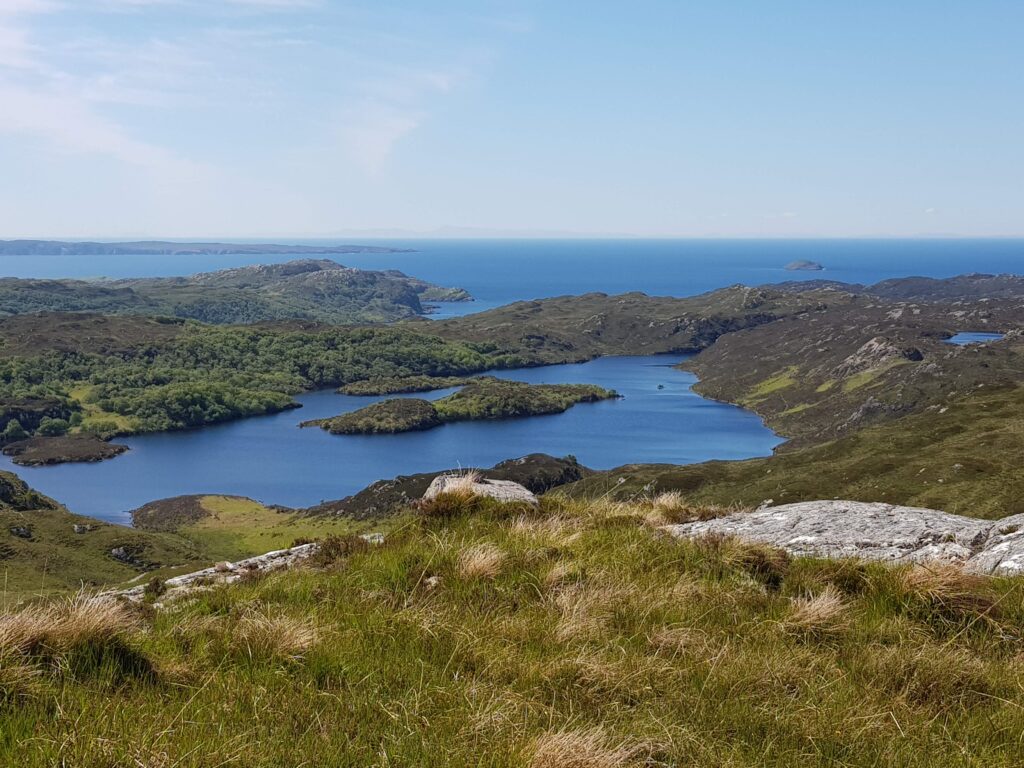
View west from Fàire nan Clach Ruadha, out to sea.

There is another possibility. Walking inland, this hill is the first to give really distant views of the sea, to raise you above this land’s crinkly corrugations. In the photo above you can see the Achiltibuie peninsula, top left, about 10 km distant. The faint smudges of the Outer Hebrides are clearly visible to the naked eye. Maybe this was a place to look out for ships. There are Norse-inflected names are present near here – Suilven and Inverkirkaig for example. Could a lookout here once have run off in terror, sprinting to give advance warning of a hostile Viking attack? On a glorious June day it seems like an impossible idea. Surely a dot on the horizon would cause joyful anticipation of a returning loved one, home from the sea.

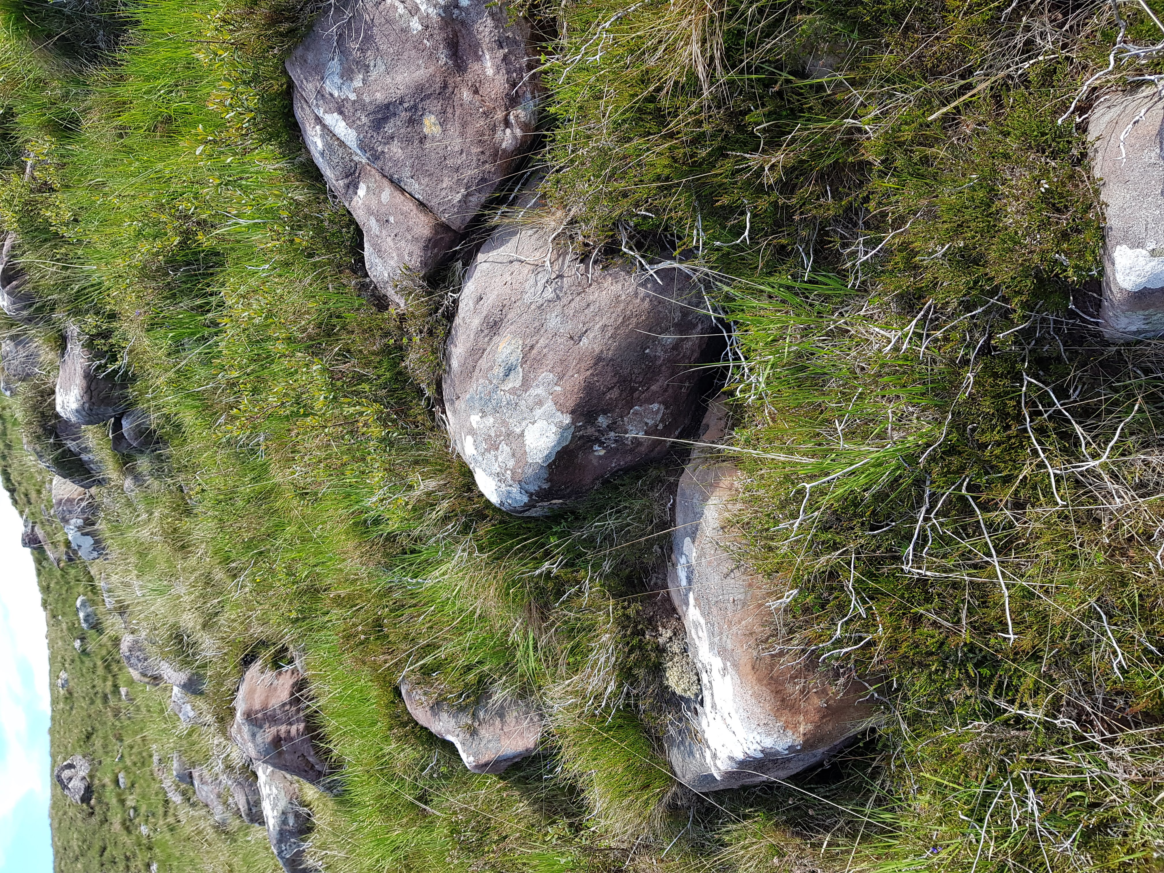
What of the “red rocks”? While the bedrock of Fàire nan Clach Ruadha is made of Lewisian Gneiss, blocks of red Torridonian sandstone are found in great abundance here littering the surface. Some sit proud on the top of the hill, but the most abundant areas are on west-facing slopes.

Red rocks
Red rocks of Torridonian sandstone

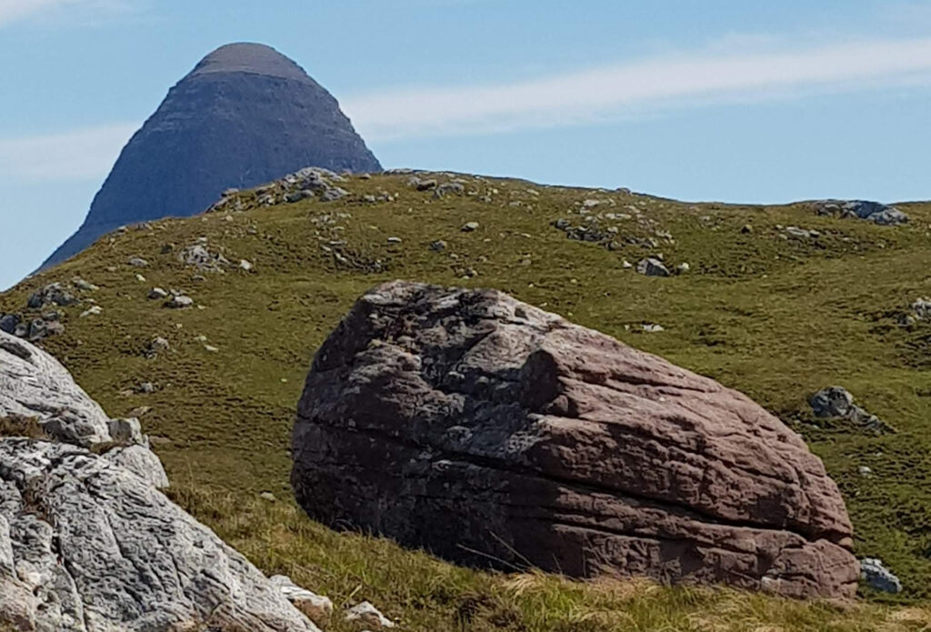
As for much of Assynt, photos taken from here become dominated by the great charismatic peaks of Suilven and Stac Pollaigh. Like being photo-bombed by a celebrity, they immediately become the focus of the image, demanding your attention through sheer charisma. These peaks are also made of Torridonian sandstone, so on Fàire nan Clach Ruadha it feels like they are proud parents, peering down upon their tiny offspring.

Suilven peering down at its little baby mountain

Imagine this is how mountains form. The big parent mountain silently urging its offspring to grow up big and strong. Perhaps they are like sharks, the biggest feasting off their siblings in a race to reach adult size. I could be in the midst of a massacre, too slow to register on human timescales.

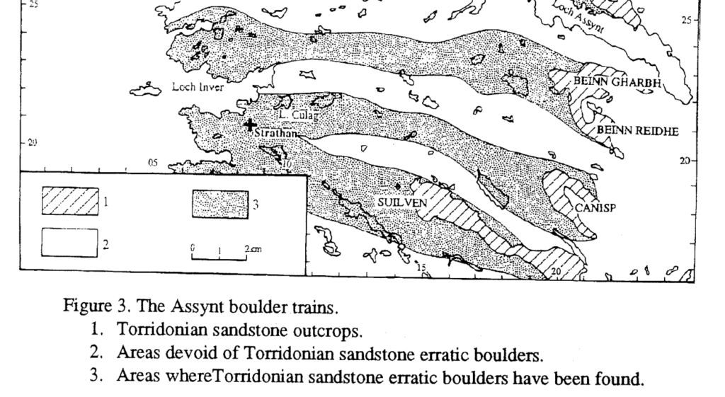
Of course this is actually how mountains die. Each block was plucked from the side of Suilven by ice and left behind by a now vanished ice sheet. We know this, as people have laboriously mapped the location of these ‘boulder trains’ of Torridonian sandstone, showing a clear link.

Image from Lawson (1995).
Fàire nan Clach Ruadha is within the boulder train coming from Suilven

This academic paper ends with a great acknowledgements section, thanking “the unstinting, though often forced, efforts of a large number of A level Geography students ….helped in the plotting… across this knurled and unyielding landscape, often in the most unhelpful of weather“.

Place names are echoes of how past generations have engaged with a landscape, a reminder that our feet are not the first to tread these rocks. Subsistence farmers on a lazy Summer’s day; somebody anxiously scanning the sea; wet and grumpy teenagers; maybe all have noticed these red rocks before me.

Earth’s layered structure

Six thousand kilometres isn’t a long way. Along the surface of the earth it’s the distance from Beijing to the Middle East. That distance above your head is still well within earth’s orbit and many satellites are much further out. The Middle East and the earth’s orbit are places we understand reasonably well and that people have visited.

In 1863 Jules Verne, a French author wrote “Journey to the Centre of the Earth” a fictional story about a team of geologists and adventurers who climb down a hole in a volcano and reach a huge space within the earth full of prehistoric animals. Nothing he wrote was inconsistent with scientific knowledge at the time, because we knew virtually nothing about the deep earth. 

But now we know that 6000 km down below your feet is a place that humans can never reach, that’s very different from the surface. The deep interior of the earth is a place of unimaginably high pressures and temperatures, where solid rocks flow and from which come diamonds, huge volcanic eruptions that poison the earth and also a magnetic field that protects all life from harmful radiation.

Think of a plum. There’s a very thin skin at the surface, then the sweet juicy flesh making up the biggest part of the volume and a very different part in the middle. The earth’s internal structure is like a plum. The thin skin is the crust, the next layer down the mantle and the portion in the centre is the core.


Temperature and Pressure

The very centre of the earth is 6378km deep and is hotter than the surface of the Sun (estimated 6000°C). The earth is still hot after 4.5 billion years as it contains radioactive elements such as Uranium and Thorium that slowly produce heat as they decay into other elements. They’ve been doing this for billions of years and without this heating the earth would by now be much cooler. 

The temperature slowly increases down from the surface – this is known as the geothermal gradient. Miners have always known about this, rock temperatures in the world’s deepest mines (nearly 4km deep) reach 60°C and air conditioning is required to allow the miners to work safely. But this depth is a tiny way into the earth and temperatures keep going up right to the centre of the earth.

Pressure is caused by the weight of material pushing down on something. We live in air pressure every day (caused by the weight of air above us) and only notice it when it changes (like up a mountain or travelling by airplane). Air pressure is around 100,000 Pa (Pascal, the SI unit of Pressure). The most severe pressures humans have experienced are in the deepest parts of the ocean. To travel there we need specially made spheres of the strongest metals. This is needed to protect humans from the pressure of 10 kilometres of water (c. 110,000,000 Pa).  Within the deep earth the pressure is from the weight of thousands of kilometres of rock, which is 2-3 times denser than water. Pressures in earth’s core are estimated to be 330,000,000,000 Pa. Under these conditions, no materials behave like they do at the surface. Atoms are squashed together so tightly they form structures that are very different to those under lower pressures.

The Core

The very centre of the earth is known as it’s core. The core is made of Iron, mixed in with minor amounts of Nickel and other elements that mix easily with iron. We don’t know for sure as we have no samples (and never will, to get sample you’d have to destroy the earth first). It’s likely though it is similar to iron meteorites as these are from the cores of other broken up planets that formed in the same way as the earth. 

Seismology shows that the earth’s core is made of two parts, a liquid outer and a solid inner. Metals melt when they are hot, so the fact the outer is liquid is not a surprise. It flows and these movements cause the earth’s magnetic fields. Under intense pressure even materials that are very hot can form solids. High temperatures cause atoms to vibrate and move apart, but high pressures force the atoms back together where they form bonds and become a solid. In the inner core the effect of the incredible pressure forces the hot metal to become solid.

Patterns of seismic waves suggest there it’s not the same all the way through as they travel in different speeds along different directions. There’s no clear agreement though. Understanding the inner core is like trying to understand a room only by listening to sounds through a locked door: extremely difficult.

Rocks and minerals

The other layers of the earth, the mantle and crust, are made of rock and rock is made of minerals. Let’s talk about rocks and minerals before describing those layers in more detail.

The most common type of minerals on earth are called silicate minerals. These are formed from regular rows or grids of Silicon and Oxygen. A Silicon atom surrounded by four Oxygens is called a silica tetrahedron and it forms a strong stable pyramid structure. Quartz, which is common in the contintental crust and makes up sand, is made solely of silica tetrahedra. In other silicate minerals the silica tetrahedron are mixed with other metals, commonly Iron and Magnesium, Calcium and Aluminium. Also the tetrahedron can be joined together to form chains or sheets or many other structures. The variety of structures and number of other atomic elements that can be included together make an enormous range of minerals. Hundreds of minerals exist, with names from Amethyst to Zircon.

<diagram showing silicon tetrahedron https://en.wikipedia.org/wiki/Silicon%E2%80%93oxygen_tetrahedron>

All minerals are formed from regular structures which give them consistent properties. 

By contrast rocks are just mixtures of minerals bound together in all sorts of different ways. The mineral grains can be small or large, varied or all the same, randomly mixed or shaped into patterns. Most rocks are made of silicate minerals and only a few common minerals are not silicates. Important ones include calcite that forms limestones at the surface and diamond that is formed in the earth’s mantle.

The mantle

The mantle is the layer of the earth from the top of the crust (2285km depth) nearly to the surface (on average 10-30km depth). Chemically it is doesn’t vary very much, always being made of silicate minerals rich in Iron and Magnesium with only minor amounts of other elements. This type of composition is known as ultramafic.

Slices of mantle sometimes make it to the surface, where it’s usually made of a rock type called peridotite including minerals called olivine and pyroxene. It’s heavy and dark, usually looking unusual compared to the more familiar rocks of the crust.

Mantle rock deeper in the earth is chemically the same, but made of different minerals. Like between the inner and outer core, the reason for this is an increase in pressure.

As pressures increase deeper in the mantle different types of mineral stop being stable but instead are replaced by more exotic ones with a similar chemistry but different more compact structures and names like perovskite and bridgmanite. Under these higher pressures, silica tetrahedra are no longer stable, instead atoms are packed together more tightly in different ways. The change from one mineral type to another occurs over a small range of pressures and is called a ‘phase transition’.

Seismic data shows faint changes in rock properties at depths of 410 km and 660km depths. These ‘discontinuities’ occur not because the mantle composition changes, but because it’s where these phase transitions occur. The upper mantle is defined as that above 410km discontinuity which is where the pressure is reached at which olivine is transformed. The transition zone continues down to 660km where another complicated phase transition marks the top of the lower mantle.

Studying high-pressure minerals

We’re stuck at the surface, but we can study these exotic high-pressure minerals in two different ways, both involving diamonds.

Diamonds are a high-pressure form of pure Carbon that grow within the earth’s mantle and are brought to the surface in odd volcanic structures called kimberlite pipes. Some diamonds contain inclusions of these deep mantle minerals, which make them useless for jewelers but great for scientists. 

Scientists also reproduce conditions deep within the earth using diamonds in the laboratory. To create intense pressures they squash samples between two super-strong diamonds. Firing lasers through the diamonds increases the temperature of the sample also. These experiments allow us to reproduce the phase transitions and so link them to the discontinuities we see in the seismic data.

Mantle flow

One of the most remarkable things about rocks deep in the earth is that they flow, even while they remain solid. Only very small areas of the mantle are molten, but all of it flows. Hotter material at the base flows upwards, cool and sinks down. Remember that this happens very very slowly. Rocks move only a few centimetres a year so a journey from top of the mantle to the bottom takes 100s of millions of years. To understand how, we need to talk about minerals again.

Silicate minerals are made of regular rows and layers of atoms. Under pressure, at high temperatures, these rows or layers can move past each other, atom by atom slowly swapping around. This plastic deformation slowly changes the shape of the grains, turning spheres into pancake shapes, for example. Over millions of years, with small changes in countless numbers of mineral grains solid rocks can flow and move. Water ice is another type of mineral (just not one that forms rocks) and the flow of glaciers down hill is the same mechanism, only faster.

One consequence of the fact that rocks can flow is that the earth is not a perfect sphere. The rotation of the earth pushes material out around the equator and flattens the poles. This forms a shape called an oblate spheroid. The effect is small, but it means you could argue the world’s tallest mountain is Mt Chimborazo in Ecuador. It’s not the highest above sea-level (that’s Mt Everest) but since it is near the Equator the oblate spheroid shape means it is the furthest point from the centre of the earth.

Layers in the upper mantle

Towards the top of the upper mantle is the asthenosphere. This is a particularly soft layer that contains pockets of molten rock. Above this is the lithospheric mantle. This is material attached the base of crust and together they make up the lithosphere, rigid plates that drift slowly over the surface of the earth. The boundary between mantle and crust is known as the Mohorovičić discontinuity or “Moho”, named after the Croatian seismologist who first identified it over a hundred years ago. There are many places on earth where slices of deep rocks are found at the surface and you can stand on the Moho.

The Earth’s Crust

The top layer of the earth, the one we know best, is the crust. This comes in two types, oceanic and continental. Oceanic crust forms where plates move apart and mantle peridotite moves up towards the surface. This stays hot and as the pressure reduces it starts to melt. Melting peridotite produces magma with a different composition, more rich in Silica called mafic (meaning rich in Mg and Fe). This magma rises and cools forming the oceanic crust above. The cooling magma forms new crystals making a coarse rock called gabbro deep down and finer-grained dolerite and basalt above. Oceanic crust is only around 7-10 km thick. It’s a very thin skin indeed.

If basalt or gabbro melt, it in turn produces rocks even richer in silica called felsic (meaning rich in feldspar). Common felsic rocks are andesite and granite. Continental crust is on average of andesitic composition and much less dense and thicker than oceanic crust, on average 35 km thick. This is where all of the earth’s really old rocks are found.

The crust is where the most variety of rocks is seen as sedimentary rocks form only at the surface. Oxygen in the atmosphere and interactions with life have created many new minerals not found in the mantle. 

The Deep Earth may be somewhere that humans can never visit, but it’s different layers do interact together and sometimes affect what happens up here on the surface. We’ll discuss this more in the sections on plate tectonics.

First publication by Xiaoduo Media in Front Vision. Front Vision is a Chinese online science magazine for children. My original English text produced with permission.
The Holocene: from the Ice Age to the Age of Rice

Every day history is being made. This is true for geology as well. Out at sea layers of sand or mud are being laid down that will become the geological records of the future. The period of geological time that we are in right now is called the Holocene epoch, which is part of the Quaternary period, which is part of the Cenozoic Era. Let’s take a step back and tell the story of how we got to the Holocene.

The Cenozoic Era started 66 million years ago with the extinction of the dinosaurs, at a time when massive volcanic eruptions and a huge meteorite impact caused enormous changes to life on earth. With the dinosaurs gone (apart from birds, which are types of dinosaur – just look at their feet!) mammals were able to evolve into new species. The earth’s tectonic plates continued their slow dance. The Atlantic ocean continued to open, splitting Europe from North America (they used to be joined together). The Indian plate (which used to sit alongside Africa, Antarctica and Australia) moved quickly north and around 60 million years ago punched into the Asian plate. This started to form the huge mountains of the Himalaya, the high Tibetan Plateau and the the Tian Shan. Moving through the Cenozoic, animals and plants and the geography of the earth become more familiar. Grasses first become important around 40 million years ago. Also animals that eat grass, like horses and cattle. One thing that was different was the climate, which was much hotter, with higher levels of CO2 in the atmosphere and no ice caps.

Significant glaciers started to form in Antarctica around 34 million years ago. By the Quaternary period the earth is in an Ice Age, with large ice caps on Greenland and Antarctica and permanent glaciers in high mountains around the world. The Quaternary started 2.588 million years ago and it hasn’t ended yet. There have been ice ages before, during the Proterozoic – when the earth nearly froze completely – also in the Ordovician and the Carboniferous. These are times when the levels of CO2 in the atmosphere are relatively low. As ice caps lock up lots of water, sea levels tend to be low also. The amount of ice is relatively sensitive to changes of the earth’s spin causing changes in the amount of sunlight the earth receives. Tiny variations in the spin of the earth, caused by the irregular tug of other planets in the solar system are called Milankovitch cycles. There are different Milankovitch cycles that move at different speeds, so the pattern is complicated, like listening to many drummers who are moving at different speeds. The main effect is a pulse of between 40,000 to 100,000 years. We see this as dramatic changes in the volume of ice and of the climate of the earth. These are called glacial and interglacial periods and the earth has moved back and forth between them through the Quaternary.

We know what an interglacial period looks like, as we are in one right now. During past glacial periods, New York was covered by a layer of ice many kilometres thick, as was northern Europe. In China, the ground was permanently frozen as far south as Beijing and most areas were desert. Finely ground rock, from ice caps and glaciers further north or in the Himalayas was blown across this desert building up thick deposits of a fragile yellow soil called loess. An area called the Loess plateau covers the upper and middle parts of the Yellow River and makes excellent farmland. The soil erodes easily and the Yellow River’s name comes from the large volumes of eroded loess that it contains.

The Holocene epoch started 11,700 years ago and it’s the period of time since the end of the last glacial period. During it the climate has been relatively stable, with limited ice cover. But there have been many changes over that time. The first half of the Holocene saw areas that had been covered by ice slowly move to more modern conditions. Sediments in lakes contain ancient pollen and allow the plant species in the area to be identified. In many places there was a slow return of forests, with more and more species becoming established as thousands of years passed. Tropical rain forests, like the Amazon, were quite restricted during the glacial period and they also grew rapidly during the early Holocene. Some climates were very different. Parts of what is now the Sahara desert in Africa was a fertile place during the Holocene. Here we have evidence from ancient humans. Cave paintings show the hunting of giraffes and other large animals in places now barren desert.

Human beings are the most remarkable thing about the Holocene. The history of human evolution is complicated. Creatures clever enough to make stone tools have been around for 2.5 million years, but the oldest known fossils of modern humans (Homo Sapiens) are 300,000 years old. By 50,000 years ago humans had spread from Africa across much of the world and were using sophisticated stone tools and burying their dead. They were as clever as us, but had very little technology to help them.

Even with simple stone tools, humans made an impact. The ground in Siberia is frozen. Within it people find the corpses of extinct animals, like giant wooly elephants called mammoths. These animals used to be extremely common, but they became extinct during the early Holocene. Why? The changing climate might be responsible, but some believe that intense hunting by human beings is the main reason. In many sites across the world we have evidence of humans killing and eating large numbers of mammoths and other extinct animals. There is a debate about the most important cause of extinction, but it’s clear that even simple stone tools could be extremely effective.

Also human brains can be deadly. One effective method of hunting mammoth and other animals that live in herds was to scare them and drive them over cliffs, where they fell and died. During the Holocene humans took advantage of the improving climatic conditions to develop more and more new skills and technologies. The impact of increasing numbers of humans and their increasing ability to change the earth and the animals and plants upon is a theme of the later Holocene.

When populations of humans are small, we can live by hunting animals such as mammoth and gathering wild foods, like nuts or shellfish. Such foods are rare, so groups of humans would often move, following migrating animals, moving to different foods sources throughout the year or simply moving to new places. From the early Holocene we have evidence in the Middle east of the first villages or towns. For people to become settled, we need a reliable source of food that can be stored to provide food all year round. These first villages were based on harvesting grains from grasses – wild versions of modern day wheat or other cereals. Over time, selection of the best wild grains lead to the breeding of domesticated versions. These may require human intervention to thrive, but gave a good yield of food. A similar process occurred with animals. Wolves became dogs, who could help defend herds of domesticated sheep from attack by non-human predators. Hunter gatherers became farmers. Over time the same process affected fruit and other vegetables. Plants with small bitter fruits were slowly changed by selecting the best ones to end up with the large and juicy fruits we enjoy today. Very little of what we eat today is truly wild.

This process happened in different areas based around different foods. People in Central America domesticated maize from around 8000 years ago. In China and southeast Asia people started growing rice and eating it from around 7500 years ago.

Once people have worked out how to grow reliable sources of food, they can move across the land, spreading their seeds and animals as they go. We can trace this via records of pollen in lake sediments and other wet places. In places that were previously covered in trees, farmers would remove them, dramatically changing the landscape. The natural regeneration of forest, with seeds growing into trees is broken by domesticated animals like sheep eating the young trees. The wide open mountains and fields of the British countryside, for example are entirely man-made.

In a group of hunter-gatherers, groups of people tended to be small and most were involved in producing food. As farming villages became towns, a group of people emerged who did not need to directly work to produce food. These people – kings, priests, merchants, craftsmen and others had the time to produce new things, like writing, organised religions, metal objects and so many other things. In some places the nature of the farming required many people to work together. In the Mesopotamian basin (modern-day Syria and Iraq), where some of the earliest towns were formed, systems of irrigation were required to get water from narrow rivers into broad areas of farmland. Technology itself sometimes also encouraged the growth of large kingdoms. Bronze is a metal alloy produced from a mixture of copper and tin. In the eastern Mediterranean of Europe there is copper, but the tin had to come from far away, like Afghanistan or the British Isles. Only large kingdoms or empires had the resources to bring together such distant materials.

The period of time when people are using Bronze is called the Bronze Age and it was followed by the Iron Age and so we are moving into history rather than geology. Let’s take a step back and consider this enormous change in human activity from the point of view of the wider planet. Even at the start of the Holocene, humans may have been causing extinctions of animals. The rate of extinction has only grown since then, with no sign of stopping. Direct hunting is not the only cause. Farming landscapes are very different from ones untouched by man and while some animals have adapted (rats, for example), many have not.

Some human impacts on the planet that we think of as modern are surprisingly old, for example pollution. Ancient layers of ice in the Greenland ice cap are a record of atmospheric pollution. Each layer is a record of ancient snow, plus trapped bubbles of air. Studying this record shows traces of lead pollution from Roman mining in Spain from over 2000 years ago. Similar records from South America show the traces of local mining from 3500 years ago.

These ancient traces of human activity are dwarfed by the current impacts. During the Quaternary and most of the Holocene, CO2 levels slowly varied in step with Milankovitch cycles. Human burning of fossils fuels has dramatically changed this. Levels of CO2 are now higher than they have ever been before in the Holocene or even the Quaternary. Some geologists argue that the Holocene is over and that we are now in a new geological Epoch, that they call the Anthropocene.

First publication by Xiaoduo Media in Front Vision. Front Vision is a Chinese online science magazine for children. Reproduced with permission.