All the tea in China

“Is there any tea on this spaceship?” Arthur Dent, the Hitchhiker’s Guide to the Galaxy.

I’m sitting here with a steaming cup of inspiration at my side. An Englishman drinking tea from a porcelain cup stirred by a spoon: what could be more ordinary than that? But dig carefully into what led to this scene and you can find stories of magical transformations, global trade, empires and planet-changing events billions of years ago. Let’s start with a taste of the history of tea, the enriching elixir, the healthy pause that refreshes.
The tea bush, isn’t native to Britain1; when and why did this country get into the habit of putting its leaves into hot water?

english tea

Mick Jagger and Paul McCartney discuss whether to put the milk in before or after the tea

Tea has been drunk in China for thousands of years – the plant Camellia sinensis is native there. It’s leaves are rich in caffeine, most likely to reduce damage from insects or associated fungal attacks2.

Caffeinated drinks first made a big splash in Europe in the Seventeenth Century. Coffee, sourced from the Middle East was drunk at ‘coffee houses’ alongside chocolate from the Americas and tea. Processed tea was brought direct from China by sea around Africa, a route opened up by the Portuguese the century before. Though still only available to the elite, coffee houses had an impact in many ways. As a semi-public space, typically with newspapers to hand, they were a venue for political activity: Charles II of England wanted to shut down London’s coffee houses as they contained “idle and disaffected persons” who “produced very evil and dangerous effects”. A great public outcry ensued and, not the most powerful of monarchs (his father had been executed by Parliament only 26 years earlier), Charles backed down and the seditious sipping continued. Insurance titan Lloyds of London started life as a coffee house3 around this time. Meetings of the early Royal Society, (attended by the guys who now have scientific Laws named after them: Newton, Hooke, Boyle and others) often finished up in Coffee Houses.
It’s tempting to make a link between the dramatic changes associated with this Early Modern period in history with the sudden infusion of caffeine. To drink safely in urban areas without modern sanitation you need a drink made from boiled water. Before tea and coffee became popular, this was often an alcoholic drink, wine or beer, weaker than we are used to today. It’s tempting to think of coffee and tea jolting the modern world awake one sip at a time.

6a00d8341c84c753ef0134898b1000970c-300wi

For the next 150 years tea’s popularity in the west only grew. In the period leading to American independence in 1776, the British Government’s desire to monopolise (and tax) the supply of tea to its American colonies led to the Boston Tea Party and tea-drinking being seen as unpatriotic. The Tea Act, that so annoyed the patriots of Boston was passed to help the hugely influential British East India Company, who also had a monopoly on supplying tea to Britain. This, plus high taxes led to high rates of smuggling of tea (and other goods) from France via the England’s southern coast.

Tea is native to India, particularly in Assam, but it’s leaves were seen locally as a herbal medicine rather than a way to make a drink. By the 1830s the East India Company (who by now had control over most of the Indian sub-Continent) were looking for an alternative source of tea than China and recognised a suitable climate in Assam4. Initially plantings were made of transplanted Chinese plants, but the native varieties fared better. Tea plantations spread, soon taking in the area near Darjeeling and eventually spreading to Southern India and Ceylon (modern-day Sri Lanka). All these names are now also varieties of tea. By the early Twentieth Century tea drinking became popular in India itself, characteristically as milky, sweet and spicy Chai5.

article-2656189-1EBC4DBF00000578-560_634x420

By the second World War, tea was so ingrained in British culture that a regular supply of tea was seen as the second most important factor in troop morale, behind actually winning and ahead of food6. The UK government took control of world supplies of tea 7 – and assigned it first to troops, then to home front, then the rest of world. This caused problems for the Irish republic, whose tea habit was at least as strong as Britain’s and whose trade mostly passed through the Empire it had freed itself from 20 years before. According to an not entirely impartial history of the time8: “The Irish government, no doubt fearful of a mass revolt in the event of tea shortages, set up a private limited company, Tea Importers (Eire) Ltd., in order to start importing tea directly from country of origin” (emphasis mine).

Tea drinking is now in decline, with Britons seduced by the delights of espresso and cappuccino, but new delights such as green or white tea are now available. Tea’s global spread was part of the Western Imperial phase of globalisation – unequal trade enforced by gunboats. The current phase of global change is in many ways more equal: major UK brand Tetley Tea is now owned by Indian conglomerate Tata following an amicable takeover.

Those of you hoping for more Geology will be pleased by the next posts in this series, when I turn to the cup and the tea-spoon.

Wooden layers through time

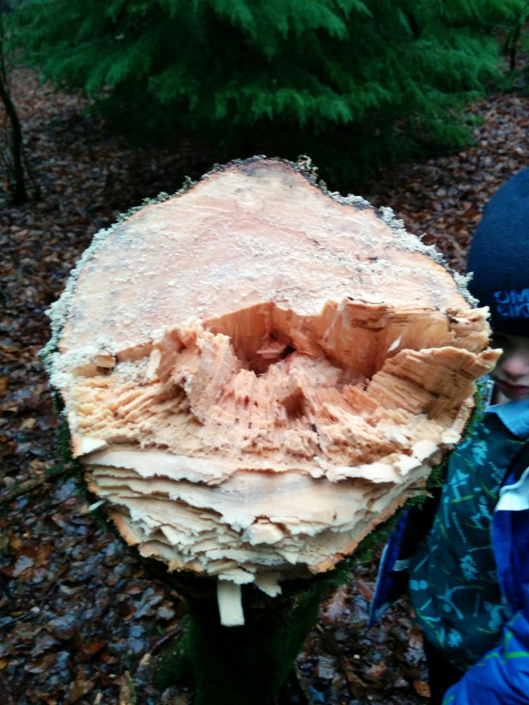
As I chopped my first tree down it was wonderful to realise that – of course – counting the rings would tell me how old it was. Traversing through the layers of wood and so through time is one of the ways in which trees stimulate the imagination. As with wood, so with woodland.

IMG_20150718_165328

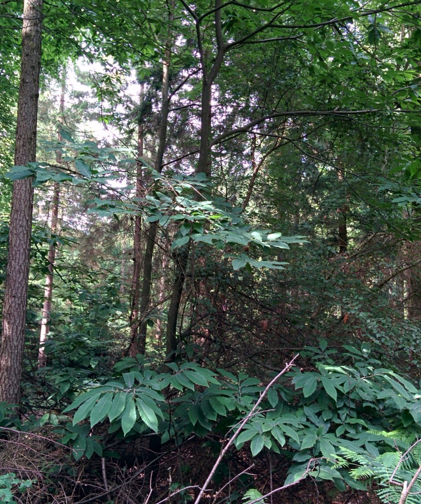
Woodland in the Summer

Layers of life

The leaves lying on the ground fell only a few days ago, transforming the appearance of the woodland. The tops of the high beech trees are no longer shrouded in deep green mystery, their bare crowns are suddenly visible. By contrast the evergreen conifers seem almost luminous, dangerously catching the eye of a new woodland owner keen to make his axe a bit less shiny.

You always know what time of year it is in an English wood. The annual cycle of deciduous trees – winter starkness alternating with the lush privacy of summer – is matched on the woodland floor. Beech woodlands in the Chiltern hills of southern England are renowned for the spring flush of bluebells, as these and other spring-flowering plants make the most of the returning warmth in the brief window before the trees come into leaf and plunge the ground below into a dappled gloom.

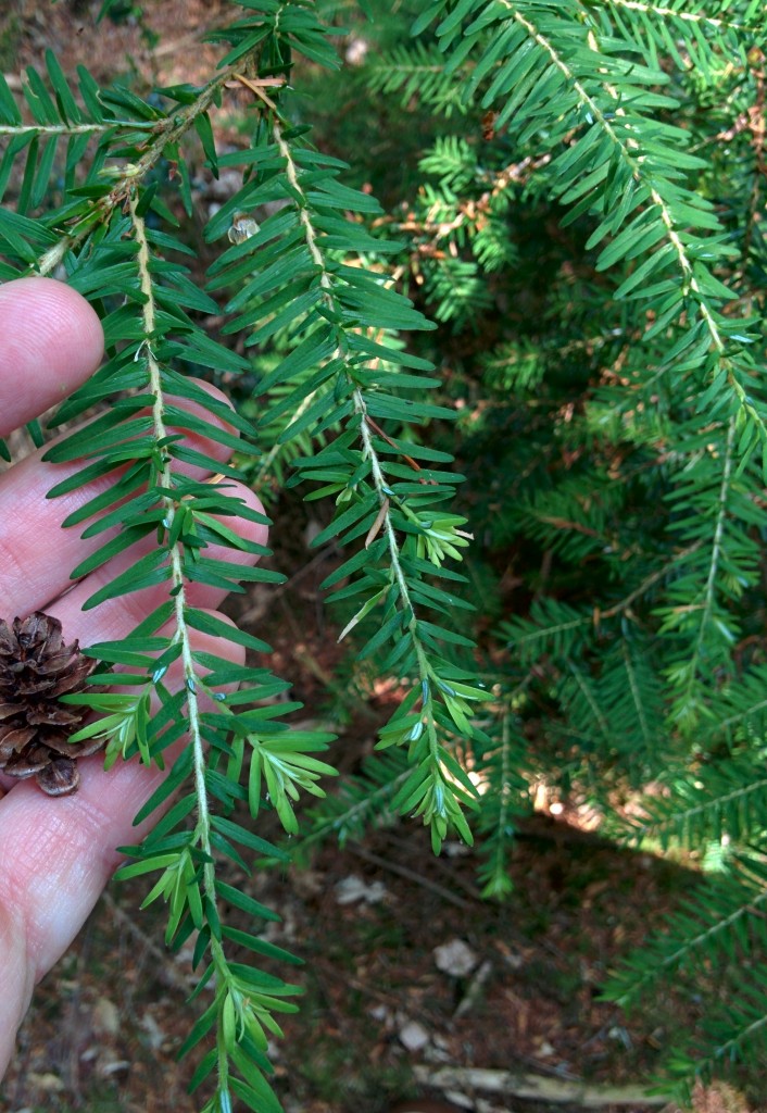
Moving our sights up to the layer above we enter the world of saplings and small trees. Here they grew during the last 30 years, when very little happened to this woodland1. Some areas have a spread of native species: beech, oak, wild cherry, birch, rowan and doubtless others I’ve not spotted yet. Elsewhere flocks of fluffy evergreen western hemlock spruce saplings have spread wide beyond the base of their mother trees.

IMG_20150808_131817 (1)

Western Hemlock Spruce

Many woodland owners see these as alien intruders, to be quickly exterminated. The bad reputation non-native conifers now have has a reasonable basis – shed needles acidify the soil and native wildlife can be baffled by the unfamiliar habitat. Four legged invaders such as grey squirrel and edible dormouse also roam the area, stripping bark and damaging trees. But arguments framed in terms of ‘alien invaders’ swamping the ‘natives’ who truly belong here are obviously bogus and repellent when applied to people. Is it really that different for trees? Why not view these saplings as second generation immigrants, adding variety and interest to their new home?

IMG_20160103_151804

Nature versus nurture

Trees aren’t people of course, which is why it’s OK for me to attack them with an axe. In doing so, I’m part of a long tradition. These woods have been used and managed by humans for hundreds, probably thousands, of years. The large evergreens (larch, spruce and western red cedar) were planted during the ‘locust years’2 the period after the second world war when ‘scientific’ management was applied to British woodland. During this time ancient trees were cleared or even poisoned and great numbers of fast growing softwood trees planted, to be managed on an industrial scale. This caused great damage to wildlife, not purely because of the species chosen. Old gnarled half-dead trees are a great habitat, and the new trees were planted for timber, meaning close together so they grow straight. In the gloom below, little grew.

So did this invasion of aliens destroy a primeval forest, in tune with nature? Not at all. The North American concept of old growth forest simply doesn’t apply on this busy little island. For several hundred years the traditional beech woods of the Chilterns were managed for the furniture trade, especially here, near to High Wycombe. The ‘last bodger’ Owen Dean worked close nearby. Bodgers were craftsmen3 using traditional tools to make furniture within the woodland itself. The grand beech trees towering up in the canopy above me now were grown for timber and so lack side branches for many metres. These same trees are seen as slender youths in pictures of Mr Dean from the 1950s.

Down into the past

To go further back in time we need to look to the layers below. The soil will contain some trace of older vanished trees, even if we cannot read it directly. The top humus-rich layer is the result of hundreds of years of leaf-fall, never ploughed and rarely dug. The mushrooms that dot the forest floor in Autumn are just minor decorations on top of the mycelium, the fine fungus filaments that thread round roots and through rotting matter. Here is a potential continuity, providing a link – even if only an imaginative one –   to the time of Shakespeare when the Chilterns were a major source of wood fuel for the nearby city of London.

This is an ‘ancient woodland’ site since we know if has been constantly wooded since at least 1600. Before this time we can only guess what grew and how it was used. Before oak trees were selectively removed to build the sinews of empire (bark for tanning leather, beams for warships) and beech favoured for furniture this was likely a mixed deciduous woodland made up of species that crept north into Britain after the end of the last Ice Age.

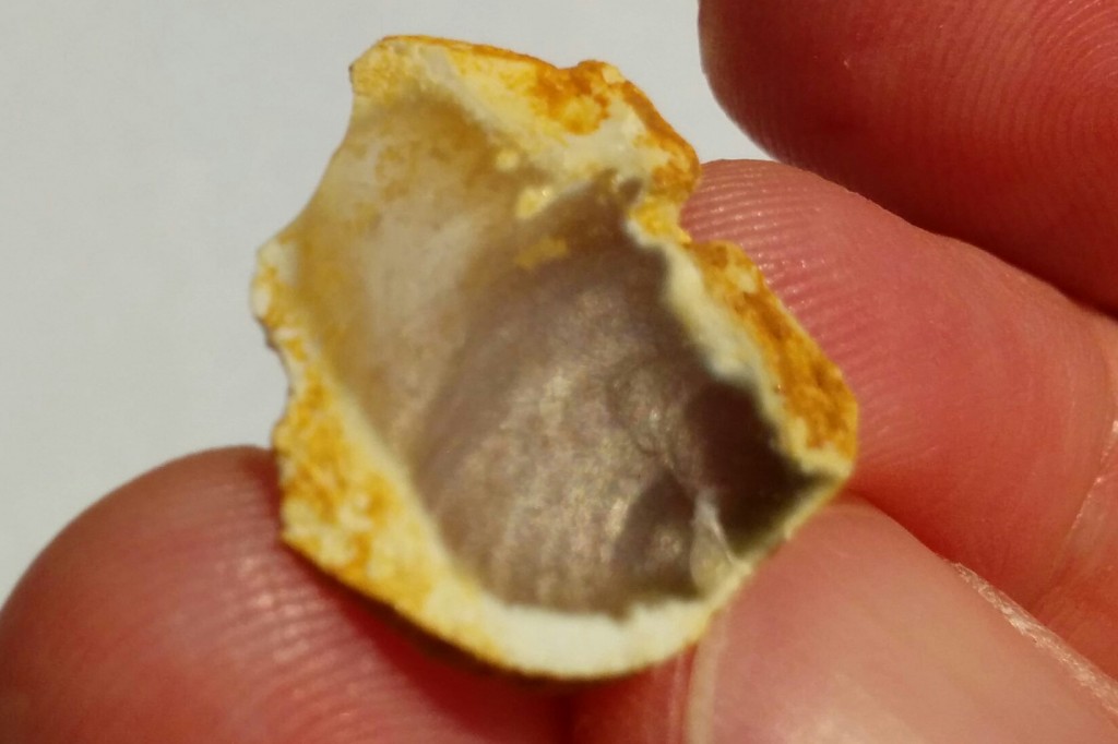
Humans were here too, for thousands of years. At some point a person sat on a stump to knap flint – banging pieces of this glassy stone together to make a sharp edge. I’ve yet to find a tool – an arrow head to kill deer perhaps, or an axe to chop firewood – but some of the useless discarded chips were in the first upturned tree I found.

IMG_20150719_205119

The subsoil here is called ‘clay with flints’ which while descriptive is a bit of a cop-out of a name. It is a thin layer found on the very top of the chalk hills that make up the Chilterns. It’s basically the geology of southern England in minature: after the chalk it’s just about different ways of rearranging piles of flint. Soft soluble chalk contains a lot of hard flint – at first some thought clay with flints was simply the residue of the chalk dissolving over millions of years. But it’s likely there some trace of the younger marine sediments in there as well, all mixed up by the churning of the frozen ground during the Ice Ages (the scouring ice sheets never quite got this far).

The layers below the chalk are hidden, but will include Jurassic rocks – which further east are the source of North Sea oil deposits – and perhaps Carboniferous rocks – which to the north are rich in coal. Man’s interactions with these deeper layers brings us back to surface and to the future.

Back to the future

Think about woodlands and you keep coming back to cycles – the diurnal creeping of birds and animals, the annual dance of leaves and buds, changing fashions of woodland management over the generations. The biggest and most important is the carbon cycle. Across the world, ancient forests are being dug-up and burnt, releasing fossil carbon into the air. For the moment this is giving my trees a little boost, the extra carbon dioxide having a fertilising effect. In time though – probably in my life time – changing climate will make some of my trees deeply unhappy, through drought or storms or flooding or new pests or diseases.

One of the main joys of owning this little patch of woodland – other than hitting things with an axe – is the opportunity to plan what it will look like in 30 years time and then see it come to pass (touch wood). I’m still thinking the details through. The main goals – encourage wildlife, a source of firewood, a place my family can play outdoors – are clear.  But the details – plant this, cut these down – are not. For me getting from one to the other means understanding all the layers of the wood, its past, its present and its likely future. It’s a process I’m enjoying hugely and the chances are I’ll write some more about it here. I hope you’ll be interested in what I have to say.

North American Arctic – icy beauty

Look at this. As an abstract pattern, it looks like something Gustav Klimt might paint.

But drill down into it in more detail and it changes into an uncomfortably close view of a reptiles skin.

All images in this post come from the North American Arctic – a place made beautiful and strange by ice. Conditions are so cold that the soil layers are almost permanently frozen. The rare occasions when it melts warps the ground in various distinctive ways.

Take the first image – the striking elongated light-blue lozenges are lakes. Lakes may form in the Arctic in areas called thermokarst. This a landscape full of hollows formed when patches of permafrost melt, causing hollows in the ground. These elongated examples are unusual. No-one knows for sure why these “oriented lakes” form, but they are often aligned with the prevailing wind, suggesting it has a role to play.

Here are some other examples, which seem to have edges with two sets of directions, making some of them look like badly-drawn hearts.

The lizard skin pattern above is known as “patterned ground” forms where soils regularly freeze and thaw. The periodic expansion of ice rearranges the soil and in the case of these polygons, wedges of ice may form in a regular pattern.

These processes occur in ‘peri-glacial’ environments. The term literally means “around glaciers” but it occurs over vast areas of the Arctic that are too near sea-level for glacial ice to build up. It can also occur at height in milder climates such as the Cairngorms in Britain or on top of African volcanoes (or even on Mars). During the colder parts of the current Ice Age, when large areas of the world were covered by ice sheets, the areas to the south of the ice were often peri-glacial. Ice-wedges and other peri-glacial features are relatively common in southern England where I live.

Pingoes are classic peri-glacial feature. In England these are round lakes formed when plugs of ice melted thousands of years ago as the climate warmed. In the Arctic they are 30-50m high hills with a core of ice – the name is Inuit for ‘small hill’. He is an example that is still a hills in Canada (note the patterned ground to its south).

These peri-glacial features are best seen near to rivers that flow into the Arctic. Further south, vast areas have very little soil, having been scraped clean by vast ice-sheets. One advantage of this, from my point of view, is that the geology is extremely well-exposed.

Here on Bathurst island in the Canadian Arctic, open folds in the some Devonian sediments are beautifully clear, complete with thickening of layers in the fold hinges.

These crazily-shaped islands in Hudson Bay are relics of folding deep within the earth. Imagine walking along those thin islands!

I’ll end with my favourite trace of ice in Canada.

The ghostly marks hiding under productive land in southern Canada were produced in a vast lake that formed as an ice-sheet melted. Ice-bergs floating in the shallow lake scraped along the lake-bed, leaving these ‘keel-marks’.

Beyond plate tectonics

Plate tectonics is the core unifying concept that has underpinned our understanding of the solid earth for over 50 years. To describe your research as moving “beyond plate tectonics” is quite a claim, but Trond Torsvik and the group he leads have some remarkable science to back it up. By tracking the movement of the earth’s plates over half a billion years they trace the effects of hot plumes of rock rising from the edges of structures sitting just above the earth’s core. Their research seeks to explain the origin of diamonds, immense volcanic eruptions linked to mass extinction events, the break-up of continents and how shifts in the earth’s axis caused glaciation in Greenland.

Dance of the plates

Trond Torsvik is a Norwegian scientist with a background in palaeomagnetism – studying fossils of the earth’s past magnetic field frozen in rocks – to trace the past locations of continents. Palaeomagnetism can tell you the latitude at which an ancient rock formed1. Torsvik worked with those in other disciplines – palaeontology and geology – to trace the slow joining and splitting of ancient continents.

This research (which involved many other scientists) has given us a pretty good view of how the earth’s plates moved around over the last 500 million years. But these movements are only the surface expression of the flow of the underlying rocks, the earth’s mantle. Now, as director of the Centre for Earth Evolution and Dynamics at the University of Oslo (CEED) Torsvik seeks to produce an integrated understanding of deep mantle flow – mantle dynamics – and how it drives plate tectonics and other surface processes.

Undoing subduction

The earth’s mantle convects. Although made of solid rock, over geological time-scales it flows like a liquid and we understand the physics of this process well enough to produce computer models of it. One important factor is subduction – as oceanic crust cools it sinks back into the mantle, changing the patterns of flow.

Based on our understanding of how the continents moved in the past, the CEED group (Bernhard Steinberger in particular) have calculated where ancient subduction zones were and therefore where the subducted plates ended up in the deep earth. These models of ancient mantle flow and subduction link our surface observations with deep-earth processes.

The diagrams below show how subduction zones have moved over time. The outline of the continents is fixed, representing a stable reference frame. The coloured lines show how subduction zones at the edges of plates have moved over time2.

The red lines correspond to modern subduction zones, but the colour coding shows how where they used to be in the past. Note how the western edge of the North America plate has moved east over time3. Also note how it shows the subduction zone that used to exist north of the Indian plate and which ceased around 60 million years ago as India and Asia collided (as the oceanic plate in between was completely subducted).
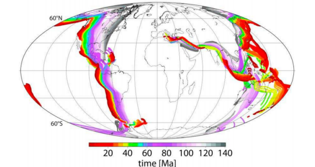
Steinberger, B., & Torsvik, T. (2012) figure 2b

Steinberger, B., & Torsvik, T. (2012) figure 2b

Here we have the same picture, but starting from 140 million years ago and moving back to 300 million years ago, the beginning of the Permian. These are the subduction zones that surrounded the ancient continent of Pangea.
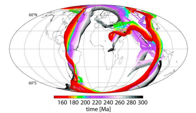
Steinberger, B., & Torsvik, T. (2012) figure 2a

Steinberger, B., & Torsvik, T. (2012) figure 2a

The diagrams aren’t showing it directly, but they remind us that the oceanic crust that passed through these subduction zones is still down there in mantle; imagine the series of coloured lines as sheet descending down into the earth – that is a rough image of what is down there.

Deep structures affect the surface

Mantle plumes have long been suggested as the cause of chains of volcanic islands (like Hawaii). Many believe the concept has been overused and that some proposed plumes don’t exist – this is a controversial area.  Torsvik and CEED have taken the debate forward by presenting a testable hypothesis – that big plumes form around the edge of structures at the base of the mantle and that this has been happening for hundreds of millions of years.

Seismic tomography shows mysterious lumps at the very base of the mantle. They are called Large Low Shear Velocity Provinces (LLSVPs) and one sits under Africa and another under the Pacific. They are probably patches of different composition, but no-one knows for sure.

The CEED group believe these LLSVPs haven’t moved for a long time, so they took their models of plate movements to show how surface features have moved over them over time. They also plotted the locations of unusual volcanic features called kimberlites and vast piles of lava called Large Igneous Provinces (LIPs). The diagram below shows an example from 160 million years ago – here they’ve plotted the ancient location of the continents, plus that of the LLSVPs (in red). Note that kimberlites are found where areas of craton (thick old continental plate shown as grey areas) are above the edges of an LLSVP. Kimberlites are the host rocks for diamonds, so this result is not of purely academic interest.
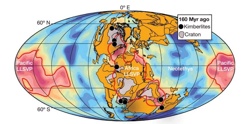
Torsvik, T., et. al (2010), figure 2

Torsvik, T., et. al (2010), figure 2

This pattern holds when the analysis is done for other periods in the past, also when looking at modern active hotspots. Put all the data together and the pattern is quite impressive. Note that kimberlites and hotspots are not shown in their current position4 but the continents are.

Torsvik, T., et. al (2010) figure 1

Torsvik, T., et. al (2010) figure 1

This is a startling result. The fit isn’t perfect (the white dots don’t fit the pattern) but nothing on this messy planet of ours ever is.

So why are LIPs and kimberlites associated with the edges of the LLSVPs? The linking factor is deep plumes, which interact with deep continental lithosphere to produce kimberlites (and bring diamonds to the surface). Big plumes cause LIPs and the one shown above around the location of modern-day St Petersburg is the Siberian Traps which caused the largest mass extinction ever know at the Permian-Triassic boundary.

Surface processes affect the deep earth

What links plumes and the edges of the LLSVPs? Think back to those diagrams of ancient subduction zones and those curtains of ancient oceanic crust sinking into the mantle. Modelling of mantle flow through time shows that the ancient subducted crust reaches the base of the mantle where it pushes up against the LLSVPs. The flow of heat from interior of the earth to the surface drives the hot material rising up through the mantle but the interaction between plate and LLSVPs provides plausible mechanisms to get plumes started – the sinking plate pushes on the edge of an LLSVP and creates domes that turn into plumes.

What I like about this work is that by presenting a clear mechanism and predictions of how the deep and surface earth work together it is eminently testable. If mantle plumes form at the edge of LLSVPs, how does this affect the chemistry of the molten rocks that reach the surface? Perhaps one side contains the LLSVP material and another not. Any new seismic tomography data can be compared with the computer models that underlie this research. Does this research give us a new way to find diamond deposits? Finding answers to any of these questions will either help confirm the hypothesis or take research in new and interesting directions.

Our wobbly world

So much science, so little time! But allow me to test your attention span a little more and talk about my favourite example of how research from CEED links the surface and the depths of this planet.

The presence or absence of ice on this planet is one of the longer-term climatic cycles observable in the fossil record. For all of the last half-billion years, glaciation has been restricted to the southern hemisphere – until the last few millions years. Climate is the major control over glaciation, but a paper this year points to three ways in which deep earth processes caused glaciation in Greenland to start.
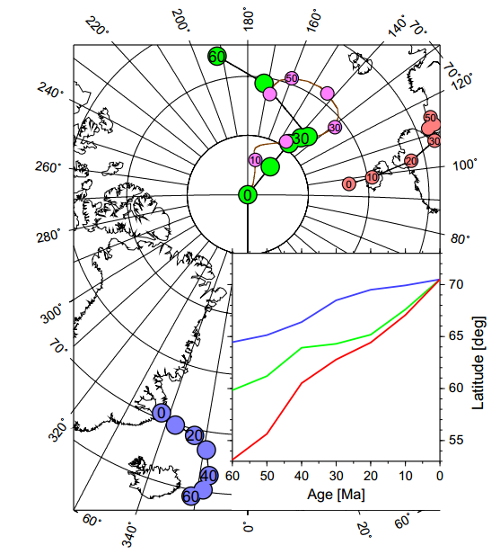
Steinberger Terra Nova figure 5

Steinberger, B., et. al, figure 5

Firstly, Greenland is unusually high (and so cold) – this is because the deep plume now centred on Iceland thinned the Greenland lithosphere and, from five million years ago, fresh ‘plume pulses’ pushed it up. Secondly, standard plate-tectonics has caused it to drift north (blue points and lines in diagram) by 6 degrees. Thirdly and most mind-bogglingly, changes in the distribution of density of the earth’s interior have caused the earth’s pole of rotation to move closer to Greenland by 12 degrees (green points are observation, pink are theoretical calculations).

If you’ve ever pushed a barrel or ball part-full of water, you’ve some sense of what lies behind the third cause, known as “true-polar wander”.  Classroom globes have have a solid rod down the earth’s axis, but the real earth does not – it rotates around an axis called the ‘maximum moment of inertia’ that is determined by the distribution of mass within the planet. If this distribution of mass changes over time, then the axis changes and the poles shift to compensate. Modelling suggests that the shift of the north pole towards Greenland was caused by increased subduction under East Asia and South America.

Plate tectonics explains subduction. But models that show subduction tweaking the earth’s axis to bring glaciers or tickling the deep earth to create mantle plumes that can kill off nearly all life, break up super-continents, and send diamonds tinkling up to the surface. That really is going beyond plate tectonics.

References & image credits

This post is necessarily a skim over large amounts of complicated research. If you don’t believe it’s true, at least read the papers yourself. All are available online.

Source of images are in the image text. All either from open-source papers or produced under fair-use.

This Nature paper links LLSVPs, diamonds, plumes and LIPs.
Torsvik, T., Burke, K., Steinberger, B., Webb, S., & Ashwal, L. (2010). Diamonds sampled by plumes from the core–mantle boundary Nature, 466 (7304), 352-355 DOI: 10.1038/nature09216

This details the mathematical models linking subduction, LLSVPs and the initiation of plumes.
Steinberger, B., & Torsvik, T. (2012). A geodynamic model of plumes from the margins of Large Low Shear Velocity Provinces Geochemistry, Geophysics, Geosystems, 13 (1) DOI: 10.1029/2011GC003808

This links deep-earth processes to the onset of glaciation in Greeland.
Steinberger, B., Spakman, W., Japsen, P., & Torsvik, T. (2015). The key role of global solid-Earth processes in preconditioning Greenland’s glaciation since the Pliocene Terra Nova, 27 (1), 1-8 DOI: 10.1111/ter.12133

This contains the detail about true polar wander.
Steinberger, B., & Torsvik, T. (2010). Toward an explanation for the present and past locations of the poles Geochemistry, Geophysics, Geosystems, 11 (6) DOI: 10.1029/2009GC002889