When continents rotate

The earth’s surface is not fixed. Oceans come and go and continents are constantly moving, breaking up and reforming like blobs of oil on the surface of a stock-pot.

Since tectonic plates are not flat (they collectively form the surface of the not-flat earth), their movement over the surface of the earth is best described as a rotation. Just as maps are distortions of the global globe-like reality, so most diagrams of plate tectonics ignore the rotational possibilities. Nonetheless, the complicated reality of plate movements over hundreds of millions of years has created some startling examples of spinning continents.

Sutherland in Scotland is a fabulous place, and has long been a geological nursery for budding geologists. Its name means ‘South-land’ in Norse, as the Viking influence  was strong. Appropriately there are strong links with the geology of Sutherland and that of Scandinavia. The phase of deformation that formed the classic Moine Thrust is linked with the Scandian orogeny, the phase of mountain building that dominates the geology of Norway.

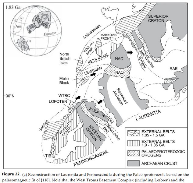
A recent open-source paper (Bergh et al. 2012) makes a more striking connection – between the ancient Lewisian Gneiss and basement rocks of similar age from near Tromsø in Arctic Norway. I went there recently and, believe me, it’s a long way from Scotland. The paper lists surveys the geological history of both areas and finds many similarities. It suggests that were part of the same orogenic belt 1.83 billion years ago, as shown in this diagram.

fig 22 Bergh et al

As is usual in such figures, the lines of modern day coasts are used to allow correlation with modern day geography. The rocks of modern-day NW Scotland correspond to the area labelled LEWISIAN, whereas the LOFOTEN and WTBC rocks are now in Arctic Norway. The outline of Scandinavia is close to its modern-day orientation, whereas Greenland and Atlantic Canada (“Laurentia”) are upside down, to our eyes.

How did we get from there to our modern-day situation?

Let’s jump forward a billion years or so.

Cocks&Torsvik2006-550

Firstly, we are now in the southern hemisphere. Secondly, Laurentia is in a more ‘normal’ configuration – the shape of Greenland is easier to pick out. The ‘Scandinavian block’ has rotated around 180° in the same way. An ocean, called Iapetus has formed between  our Norwegian rocks (marked with a little red T) and our Scottish ones (an L).

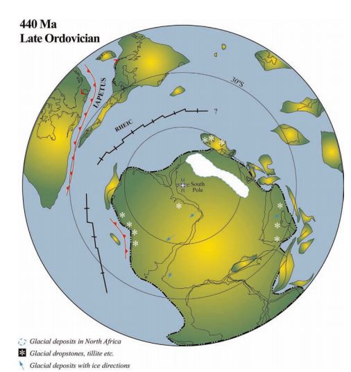
By the late Ordovician, the Iapetus ocean was closing again and Baltica is returning to collide again with Laurentia, only by now it has rotated by 180°. Again.

Ordovician plate configuration


Soon Iapetus closes, causing the Scandian orogeny which glues together the rocks of Baltica and Laurentia. Our Scottish and Arctic rocks become fixed back into a single continent. The rotation of Baltica while it wandered off means that entire length of Norway now separates two areas of crust that once were next to each other.

The Atlantic ocean has formed since then, of course, but along a line slightly different to that of Iapetus, so now the ‘Laurentian’ rocks of North west Scotland (and Ireland) are separated from similar rocks in Canada and Greenland. Will they be reunited in the future or will future continental rotations keep them apart? Only time will tell.

References

The last two diagrams are figure 2 and figure 7 from Cocks and Torsvik (2006)

Steffen G. Bergh, Fernando Corfu, Per Inge Myhre, Kåre Kullerud, Paul E.B. Armitage, Klaas B. Zwaan, Erling K. Ravna, Robert E. Holdsworth, & Anupam Chattopadhya (2012). Was the Precambrian Basement of Western Troms and Lofoten-Vesterålen in Northern Norway Linked to the Lewisian of Scotland? A Comparison of Crustal Components, Tectonic Evolution and Amalgamation History Tectonics – Recent Advances, Prof. Evgenii Sharkov (Ed.), ISBN: 978-953-51-0675-3 DOI: 10.5772/48257

Cocks, L., & Torsvik, T. (2006). European geography in a global context from the Vendian to the end of the Palaeozoic Geological Society, London, Memoirs, 32 (1), 83-95 DOI: 10.1144/GSL.MEM.2006.032.01.05

Awe in the Arctic

Last Monday night I found myself standing in the dark, on a frozen beach wearing a padded onesie and a furry hat. This is not how I usually spend my Monday nights, to say the least. It was in fact a tremendous, moving experience.

I was in Arctic Norway, near the city of Tromsø, with some friends. We were hoping to see the Northern Lights. When I say the beach was frozen, this isn’t just a figure of speech, it was frozen, the upper part covered in snow, the lower a solid lump of ice. We were prepared for disappointment; the tour we’d booked on had found us a cloud-free patch of sky, but they couldn’t do anything about the space weather. Luckily we’d already had a fabulous day.

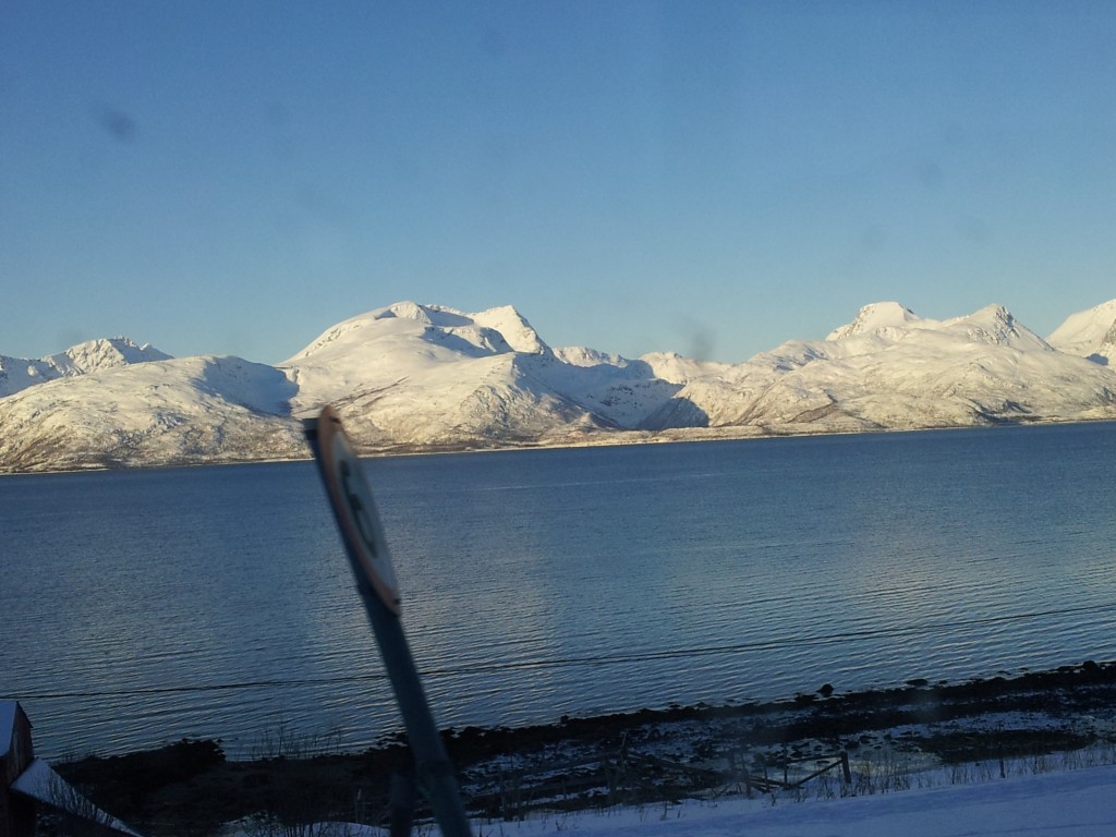
That morning we’d got onto a perfectly ordinary bus, travelling to a village and back. The bus was ordinary, the trip wasn’t. There was non-stop gorgeous scenery – very Scottish looking mountains with perfect glacial topography, all covered with snow.

Road to Oldervik

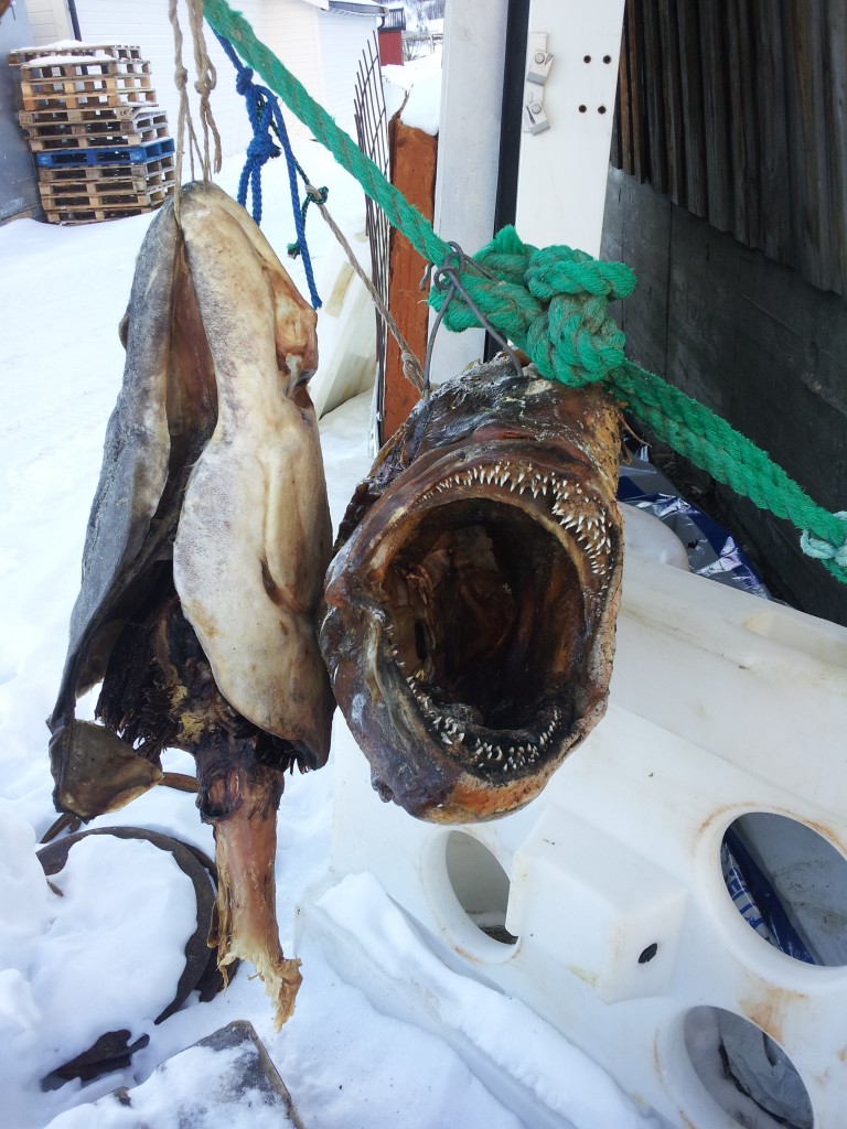
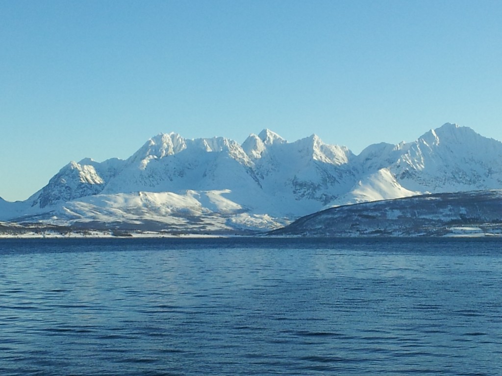
At the village of Oldervik we had 15 cold minutes before the bus took us back. To remind us we weren’t really in Scotland there were drying fish heads and really big mountains – the Lyngen Alps.

drying fish headsLyngen Alps from Oldervik
Our evening trip out to the beach was splendid as well. The moon was half out, meaning we could see a fine array of stars, but also the snow-covered mountains.
When it first came, the aurora was subtle – a faint mist only. For most of the time we saw it, it wasn’t green. Or rather it was, but the light levels were so low that human  eyesight shows only grey. The pictures you see are taken with cameras on long exposure times.

Gradually the ‘mist’ became an arc across the sky directly above us. As our guide told us about 15 times, Tromsø is the perfect place to view the lights as they form directly overhead. The lights are formed by the interaction between the earth’s magnetic field, the solar wind and the atmosphere. Electrons and ions are thrown out  by the sun and whizz towards the earth. They are then guided along magnetic field lines down into the earth’s atmosphere. Here they bump into gas atoms (Oxygen or Nitrogen) causing them to emit photons – some of which in turn pass into my goggling eyes.

The aurora showed fine dramatic timing that night. We had had a nice display, but with little movement, when it started to fade away. Just as we were telling ourselves we’d had the best of it, it came back with a vengeance. First vertical lines appeared and then it started to ‘dance’. At its most intense we saw green sheets drift and move like mist in a breeze. This was taking place all around us, above, behind, so that viewing it was a physical thing – it wasn’t over there, it was here.

aurora from Tromvik

Courtesy of @atko73, taken at Tromvik

We all had a rather strange expression on our faces while this was going on – a sort of a grin with an open mouth. We were happy and smiling, but our jaws just kept on dropping. It was literally awesome.

We all need a bit of awe in our lives now and then, a little brush with the wider universe – I feel refreshed for my little dose. What I found most interesting was the way that my awe was enhanced by my understanding of the underlying science. Knowing that the lights were caused by processes that started in places we’ll never reach – the sun and the core of the earth – simply added to my enjoyment.

Mexican silver in Tudor England

Geology and history have much in common. Both seek to understand the past by objective analysis of the traces it has left in the present. Both arose from the application of hand and mind to the study of particular things (outcrops of rock, historical documents). Both now benefit from more technological forms of analysis, as illustrated by a paper in this month’s Geology. In it, Anne-Marie Desaulty (Lyon) and Francis Albarede (Houston) apply techniques usually used in the geosciences to historic silver coins.

They dug up the English king Richard III from a car park recently. They linked the skeleton to the historical person using DNA analysis. Isotopes can be used like DNA but for ‘stuff’ instead of people.  Most chemical elements have different isotopes and usually chemical or physical processing doesn’t change the isotopic composition. In some cases the processes that formed  the stuff in the first place produced distinctive isotopic signatures. This means isotopic analysis can tell you where the stuff came from, even if there is no other way of knowing. In the geosciences isotopic analysis is used a lot – it tells us the ‘Martian meteorites’ really are from Mars – but its use in history is much rarer.

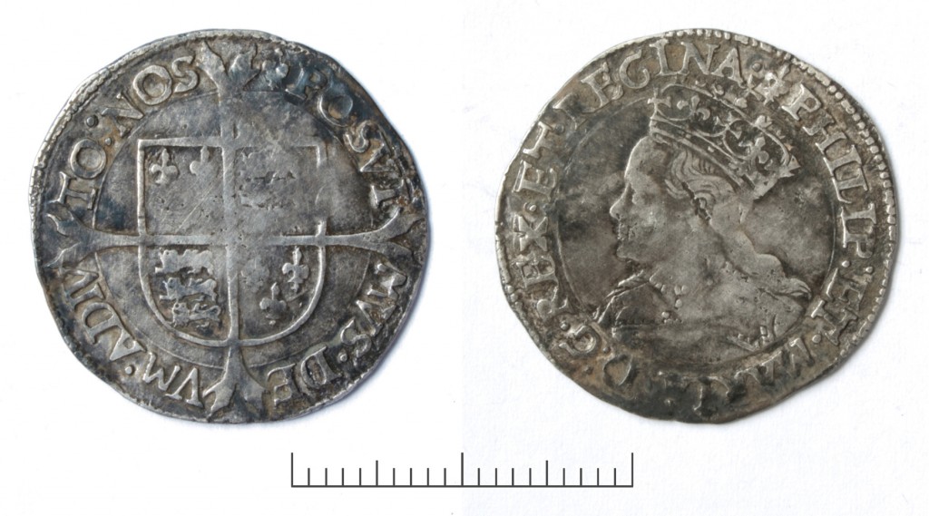
Groat Mary I

Silver groat from reign of Mary I of England.

We take it for granted that our currency is made from cheap materials – cotton paper or base metals – but this is a relatively modern innovation. In Europe coins were long made of gold and silver – materials that were laboriously mined and carefully transported across the world. Our authors use isotopic techniques to look at the silver (and trace lead and copper) within silver coins from England and trace where the silver came from. They studied coins from Mediaeval to Early Modern times: a fascinating stretch in world history.

Europe in the 16th century is arguably the first place to experience ‘globalisation’. Technological innovations from China such as printing and gunpowder were catalysing dramatic change across the continent.  Spain and Portugal were building empires in South America and bringing back such transformative substances as tobacco, potatoes, beans, corn and chili peppers. Spain was also digging up vast quantities of silver from mines in Mexico and in Peru Bolivia at the ‘rich mountain’ of Potosí.

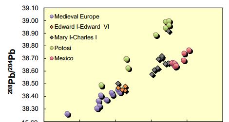
Figure DR1 from Desulty and Albarede

A portion of figure DR1 from additional material.

Looking at coins from the 13th to the 17th centuries, our authors are able to trace where the silver in them came from. The early Medieval coins are linked to European sources, mines in central Europe. At around 1553 they can see South American silver arriving and that source dominates nearly all later coins. The dilution of European sources is to be expected: we know that vast volumes of silver were mined. What is surprising is that nearly all of the silver comes from Mexican sources and not Peru Bolivia, despite Potosí having the larger output.

To explain this, our authors think globally. It’s known that much of the Spanish silver ended up in China, who adopted silver money in the 16th century. Being the most advanced nation at the time, China wanted little from the outside world other than precious metals. If European barbarians wanted their silks (or later their tasty tasty tea) they had to pay in gold or silver. This silver was thought to have flowed from Spain via Europe, but the isotopic evidence suggests that for Potosí silver this didn’t happen. For Mexican mines, the obvious outlet was by land into the Gulf of Mexico and west via ship to Europe. For Potosí the Pacific was nearer and our authors conclude that most of it ended up in China having travelled east via the Spanish empire in the Philippines.

So, silver was flowing around the world 500 years ago and isotopes allow us to track it. The potential of this technique to track such global flows is very exciting. I’ll end on a local note, however. The paper talks of an ‘apparently abrupt surge of Mexico silver in English silver coinage during the reign of Mary I’ ending the dominance of European silver. Their focus is predominantly on economic history, but surely it is relevant that the year after becoming Queen, Mary I married Philip III of Spain. Their marriage in Winchester Cathedral was a glorious occasion and descriptions emphasise the quantities of gold decoration. I’ll wager there was a fair bit of silver from Mexico around too.

Desaulty, A., & Albarede, F. (2012). Copper, lead, and silver isotopes solve a major economic conundrum of Tudor and early Stuart Europe Geology, 41 (2), 135-138 DOI: 10.1130/G33555.1

Dalradian – a Celtic Supergroup

Geology is such a great thing to study because it involves making so many connections through time and space, switching scales from the cosmic to the atomic. This means that challenge for this series of posts about the geology of the west of Ireland is going to be managing scope. So. Although I could start with the big bang, I won’t. I’ll start with the Dalradian.

A thick package of sediment, the Dalradian Supergroup, or just Dalradian, to its friends was  was named in the 19th century after Dál Riata a minor kingdom in 6th and 7th century Scotland. Dál Riata was an Irish colony within Scotland, appropriately, as Dalradian rocks are found over much of Highland Scotland and NW Ireland.

A Celtic Supergroup

To fans of 1970s Prog Rock, a supergroup is a band formed from musicians who made their names in other bands. For geologists, it means a bunch of groups that are bound together, a group being a large recognisable package of sediment. The groups usually sit on top of each and represent a period of time during which sediment was deposited. For both types of supergroup, the individual members often have distinctive personalities.

The Dalradian Supergroup is made up of the Grampian, Appin, Argyll and Southern Highland groups.

The Grampian is the solid foundation of the Dalradian, fairly calm and ordinary: the bass guitar player of the supergroup. It is a 7-8 kilometre thickness of sandstones and muddy sandstones*. In Ireland, Grampian Group sediments are found only in North Mayo.

The Appin is the lead singer: shallow, good looking and gets lots of attention. Its made up of sandstones, limestones and more muddy sediments all deposited on a marine shelf in shallow water. Now somewhat changed, it contains some gorgeous rocks.
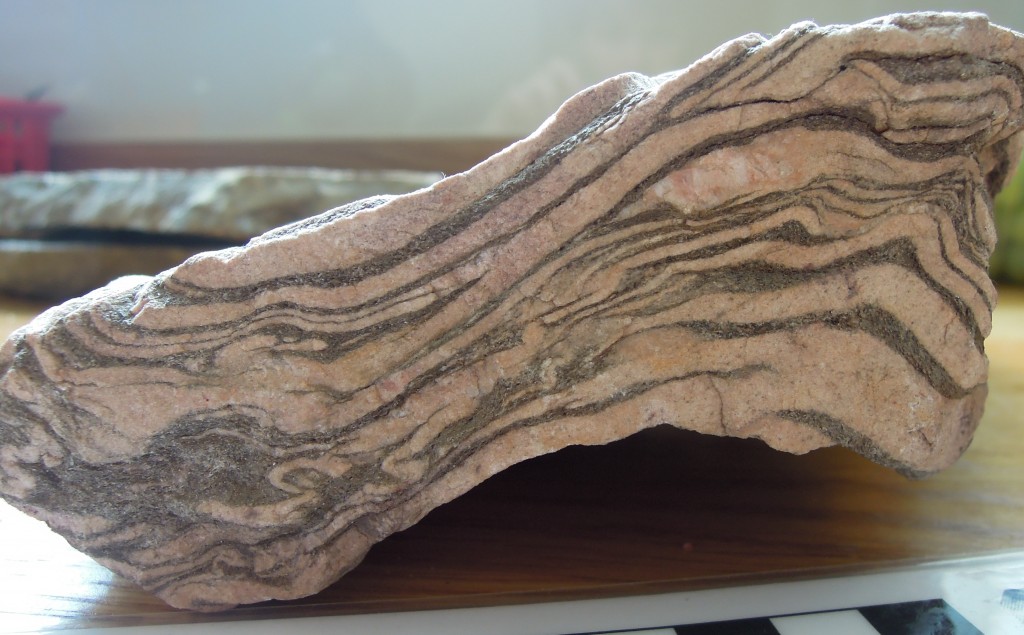
Glencoe Quartzite, Appin Group
Glencoe Quartzite, Appin Group

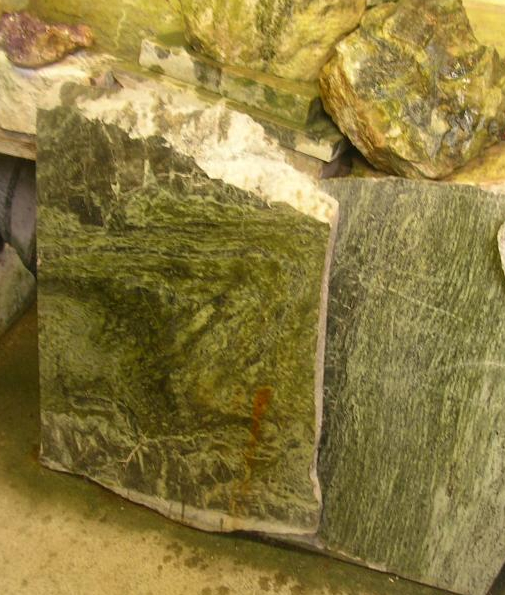
Picture of Connemara marble from

Famous ‘Connemara marble’ which is from, er, Connemara in Ireland. Picture credit.

The Appin group is found in the heart of Connemara, also across Mayo and Donegal.

The Argyll is the lead guitar. It’s deeper than the Appin and has been through some pretty intense times – brushes with death in fact. It contains the familiar sandstones and muddier sediments, but also more exotic sediment types.

Twice in the Irish Dalradian there occurs an odd pattern of rock-types. First there is a layer of sediment filled with angular fragments with a wide range of  sizes, called a diamictite. A number of subtle features show that it is sediment left behind by a glacier – it is a tillite. Immediately above is a layer of carbonate, a limestone or a dolomite. Such rocks usually form in nice warm parts of the earth so the association with glacial deposits is odd. The first of these tillilte-carbonate pairs can be traced across the Dalradian, indeed across the world. These are ‘snowball earth’ deposits. Some believe that at this time the entire earth was covered in ice, with glacial deposits forming near the equator. The overlying ‘cap carbonates’,  contain unusual carbon isotope compositions suggesting to some that life on earth nearly died at this time. This happened not just once, but twice in the Argyll.**
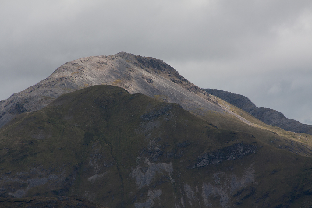
Picture of Argyll group sediments making up the Twelve bens mountains of Connemara. Image from Guilhem Boyer

Picture of Argyll group sediments making up the Twelve bens mountains of Connemara. Image from Guilhem Boyer on Flickr under Creative Commons.

The Argyll is rounded off with molten lava spilling into the sedimentary basin. Dangerous to be around for sure, but the Argyll makes the supergroup as a whole much more interesting and ‘edgy’.

The Southern Highland group is the drummer: completely crazy. The ground’s falling away under your feet, with sediments pouring into deep water and there’s another snowball earth episode***, there are big lumps of serpentinite, plus molten lava keeps coming out of the ground: madness. There’s a problem with ‘groupies’ as well. Lots of areas of sediment that say they’re ‘with the band’ but no-one is quite sure. Some of these, rocks along the Highland Boundary fault in Scotland or in Clew Bay in Ireland are worryingly young as well – Cambrian or even Ordovician. They’ve caused a lot of arguments, as you can imagine.

Song about a break-up

The Dalradian sing sad songs, about break-up: continents who once ‘were as one’ but who gradually drifted apart. It was a ménage à trois, so it was bound to end badly.

The song starts with the continent of Rodinia about 730 million years ago. This already had a rich and complex geological history which led to the creation of a large supercontinent consisting of pieces that now make up Scandinavia (Baltica), North American and NW Ireland and Scotland (Laurentia) plus Amazonia. Of course at the time these distinctions didn’t exist – it was simply a large single continent.
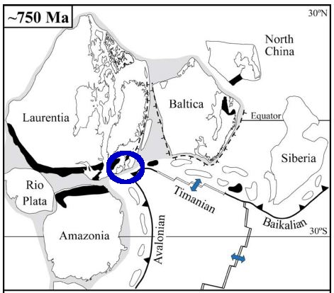
Rodinia 750 million years ago. From Cocks & Torsvik 2005

Rodinia 750 million years ago. From Cocks & Torsvik 2005

Cracks were starting to show, however. The Grampian Group formed in a rift basin, where Rodinia was starting to break-up. Early variations in the thickness of sedimentary layers suggest that faults were active during deposition. Times when the sedimentary basin became dramatically deeper also suggest tectonic involvement – active rifting was stretching the basin. There wasn’t a full break-up, however. Rifting ceased and a 30 to 40 million year period of calm saw the Appin group deposited in shallow waters under stable conditions.

The Argyll group saw rifting start-up again. By the end of the Argyll (600 million years ago) it became clear the split was going to be permanent. The stretching of the crust allowed the underlying mantle to melt, producing a ‘bimodal magmatic event’ with the intrusion of granites and the eruption of basaltic lavas. By Southern Highland group times, the sediments were forming in really deep water. Large bodies of serpentinite found in Ireland suggest the crust was stretched so much that material squeezed out from the underlying lithosphere.

This final extreme stretching marks the opening of a new ocean, called Iapetus. The opening of Iapetus created sedimentary basins all along the Laurentian margin. The Fleur de Lys Supergroup in Newfoundland and the Eleonore Bay Supergroup in Greenland were deposited in adjacent, equivalent basins. Further south in the US Appalachian belt, sedimentation associated with the opening of Iapetus starts only in Cambrian times.

Sing something simple?

I’ve told a nice simple tale, based on current scientific consensus, but it used to be much more complicated. The problem is that these are no longer sediments. Key concepts in both metamorphic and structural geology were developed on these contorted, baked and squashed rocks. Seemingly simple things like identifying the base of the Dalradian is extremely difficult as the rocks below are often also metamorphosed sediments, first transformed before the Dalradian and then deformed and heated again alongside it. Drawing a line between two types of schist requires extremely careful analysis.

The Dalradian is intruded by many granites. Most are older than the deformation, but some are younger, intruded into deep sediments in the Dalradian basin while sediment was still settling on the surface above. A date of 590Ma for one of these ‘Older Granites’ caused years of academic chaos in the 1990s as the granite was initially (incorrectly) thought to post-date the deformation, meaning that any younger sediments couldn’t belong to the Dalradian.

Geological histories hinge on tiny facts. The age of single zircon grain, a fabric wrapping an andalusite crystal: great geological narratives are built from or destroyed by such tiny pieces of evidence.
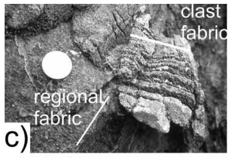
Evidence of mountain building episode during the Dalradian. From Hutton & Alsop 2004 GSL.

Evidence of mountain building episode during the Dalradian. From Hutton & Alsop 2004 GSL.

There is one inconvenient fact that might bring the whole of the simple story crashing to the ground. Respected researchers working in Donegal (Donny Hutton and Ian Alsop) have mapped an unconformity within the Argyll group. This could be consistent with our story – unconformities can form within sedimentary basins – but they interpret it as an orogenic unconformity. Based on various lines of evidence, including a tectonic fabric within sedimentary clasts above the unconformity, they infer a entire episode of mountain building took place during the gap in sedimentation shown by the unconformity. 

So is the Dalradian a single package of sediments formed during the opening of an ocean, or two packages separated by a previously unrecognised period of mountain building? I’ve no idea, but hopefully time will tell.

Regardless, everyone agrees on what happened next. Iapetus no longer exists: it opened and then it closed, moving the Dalradian from a sedimentary basin into the core of a mountain belt. That’s where we’re going next.

——————————————————————————————————————-

*they’re not sandstones any more, but we’ll come to that

** the first, the “Port Askaig Tillite” is correlated with the Sturtian global event at c. 700Ma. The second ‘Stralinchy diamictite’ with the Marinoan at c. 635Ma

*** the Inishowen and Loch na Cille beds are correlated with the Gaskiers global event at c. 580Ma

 References

L. Robin M. Cocks, & Trond H. Torsvik (2005). Baltica from the late Precambrian to mid-Palaeozoic times: The gain and loss of a terrane’s identity Earth-Science Reviews DOI: 10.1016/j.earscirev.2005.04.001

D.H.W. Hutton, & G.I. Alsop (2004). Dalradian Supergroup of NW Ireland
Evidence for a major Neoproterozoic orogenic unconformity within the Dalradian Supergroup of NW Ireland Journal of the Geological Society DOI: 10.1144/0016-764903-094

David Stephenson, John R. Mendum, Douglas J. Fettes, & A. Graham Leslie (2013). The Dalradian rocks of Scotland: an introduction Proceedings of the Geologists’ Association DOI: 10.1016/j.pgeola.2012.06.002