Structural Geology by the Deformation numbers

Structural geologists seek to understand how rocks have changed shape, in order to better understand wider processes such as how mountains are formed. Sometimes they use a terminology called ‘Deformation-numbers’ which I will now explain via a series of pretty pictures.

Structural geologists spend their day measuring the orientations of things. These can be planar things,  like sedimentary bedding, fault planes, cleavage planes and other metamorphic fabrics; or linear things like fold axes or mineral stretching lineations. All these things interact in various ways, but given time and a compass-clinometer a good geologist will work it all out.

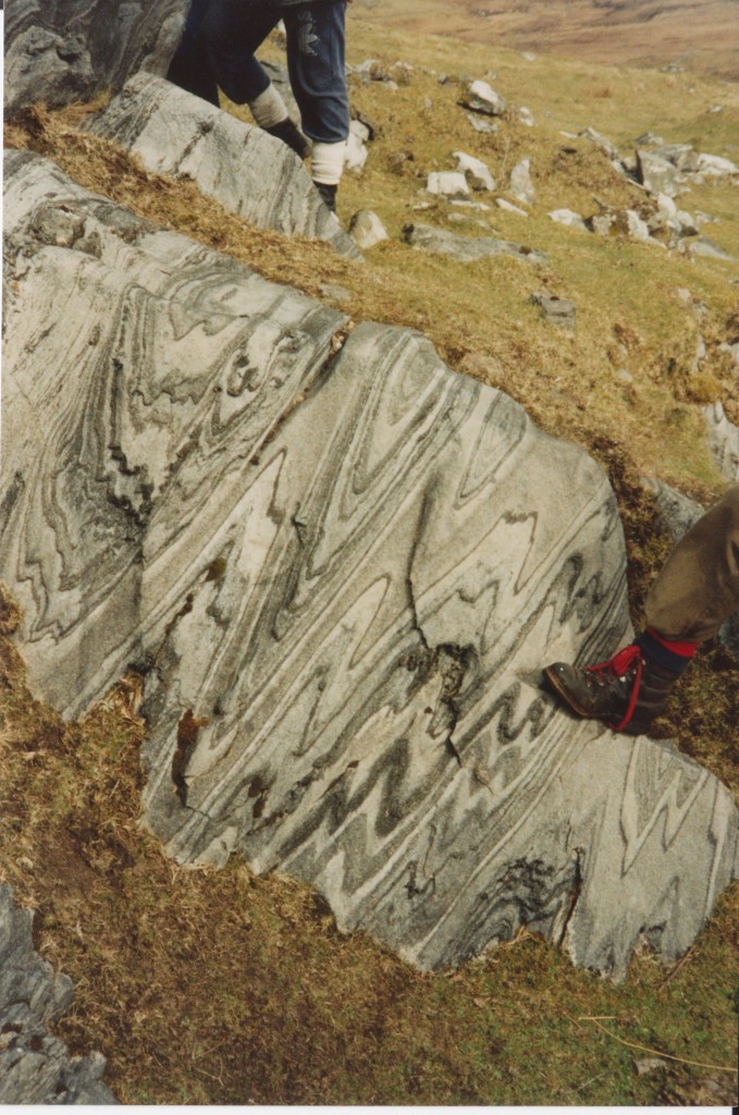
The trouble is that rocks are complicated. Take these gorgeous pics from northern Norway, kindly provided by Stephen Daly.
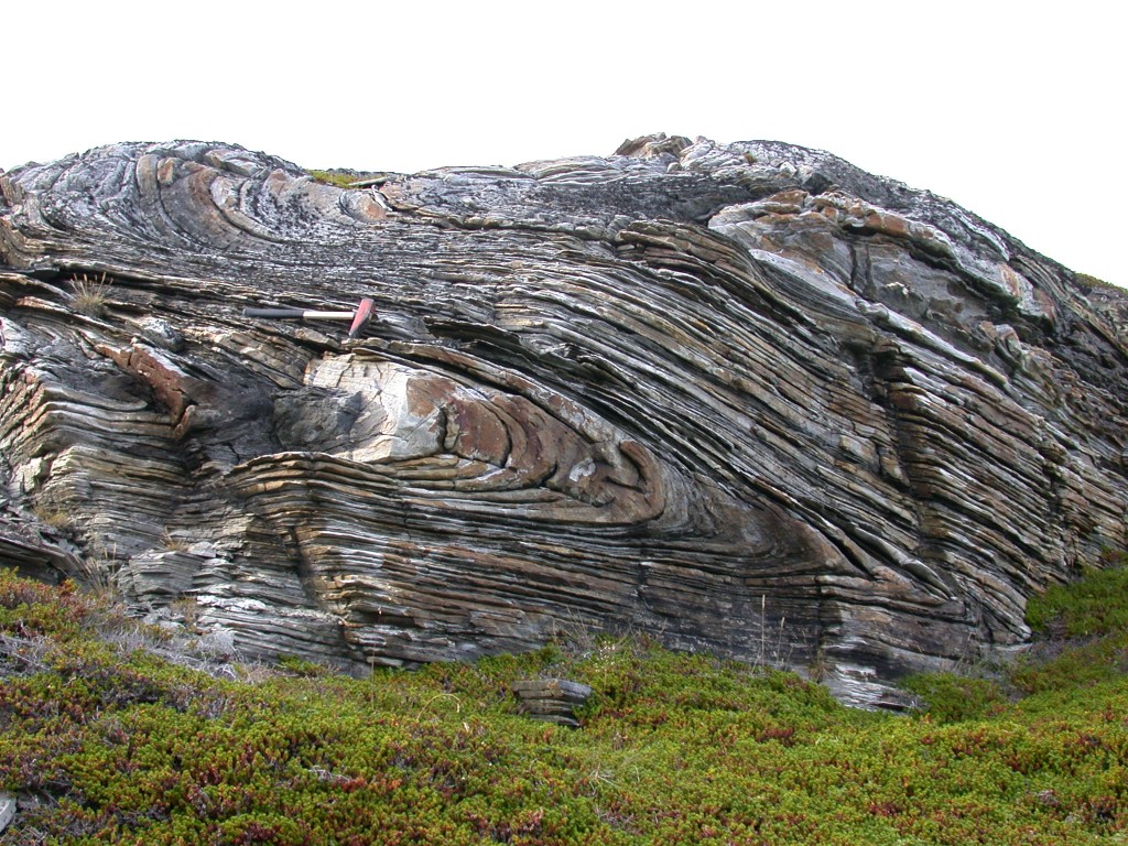
DSCN6451It’s clear that there is tight folding in metamorphosed sediments. There are things to measure the orientation of, such as hinge line (where the fold is tightest) and the axial plane, (the surface joining the hinge lines, here flat lying).

But, as so often in field geology, a closer look from the same area reveals a more complicated picture. What can you see here?
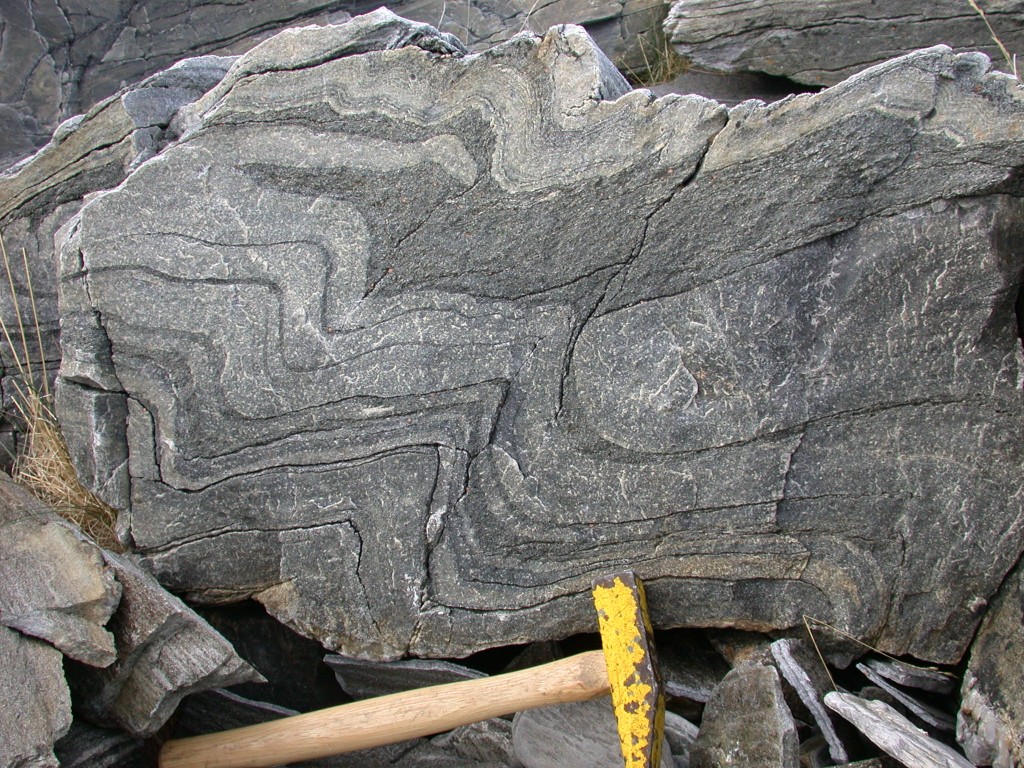
DSCN6446
There is a clear set of folding – the obvious wavy pattern of the dark and light layers. Try tracing the individual layers – they are not even. In fact there are two sets of folding visible in these rocks. Let’s trace it out.refolded annotated

The orange lines are the axial traces of the obvious set of folding. The straight blue lines are axial traces of another set of folding. The curved blue lines are the faint traces of folded sedimentary layering.

This rock has enjoyed two phases of folding – therefore any description of the deformation in such complicated rocks has to introduce the concept of a sequence of events. Geologists love this sort of thing. I remember a seminar in the 1990s about the first detailed images of topography from Venus, showing linear structures. The lecturer said that as a geophysicist his first reaction was to perform a mathematical analysis of their spacing, but that a geologist’s first reaction was to look for cross-cutting relationships. This fundamental geological instinct applies to folds as well. One of the ‘blue’ folds is clearly folded by an ‘orange’ fold, meaning that ‘blue’ is older than ‘orange’.

A simple way of expressing this is to label the folds F1 and F2. The smaller the number, the older the structure.  The same applies to other types of structures – a planar structure is know as S, starting with bedding which is know as S0. In our example S0 is folded by F1 and F2. A metamorphic fabric formed at the same time as F1, but folded by F2 would be S1. Most likely F1 and S1 were formed by the same deformation event, which we would call D1.

An Irish example

Another thread through much of geology is scale. Let’s move away from the outcrop scale to  one of kilometres. Here is a classic cross-section through the Connemara, in Western Ireland.
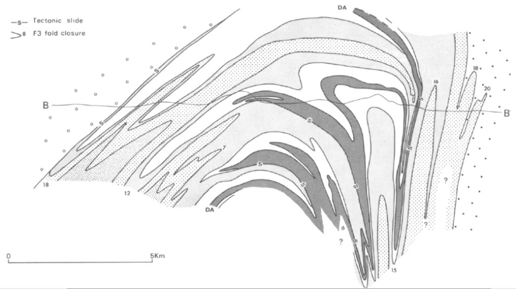
Tanner Shackleton cross sectionIf you give brilliant structural geologists enough time and enough Guinness, this is what you get. This is from the classic 1979 paper on Connemara by Tanner and Shackleton (1979). The different shades of grey each present a different group within the Dalradian Supergroup, each of which contain distinctive layers of sediment. This varied package of sediments allows the complex folding to be worked out.

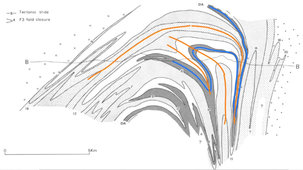
Tanner Shackleton cross section annotated

In blue I’ve highlighted the trace of the Derryclare anticline, a tight structure that folds the sediments associated with a phase of deformation know as D2. In orange I’ve highlighted a few later D3 folds that contort the Derryclare anticline. Note that these are themselves bent over by a major D4 structure that covers the whole of Connemara.

On an outcrop scale in Connemara, most outcrops show clear D3 folding as in this rather splendid marble outcrop.

Image (14)

In Connemara, a view on the kilometre scale is the best way to see D2 and D4 structures, but sometimes a closer look is best. If you glue a slice of rock to a piece of glass, grind it down to a very thin slice and shine light through it then you can look at it under the microscope. This is another way of finding structures, more often fabrics than folds.
sdfs

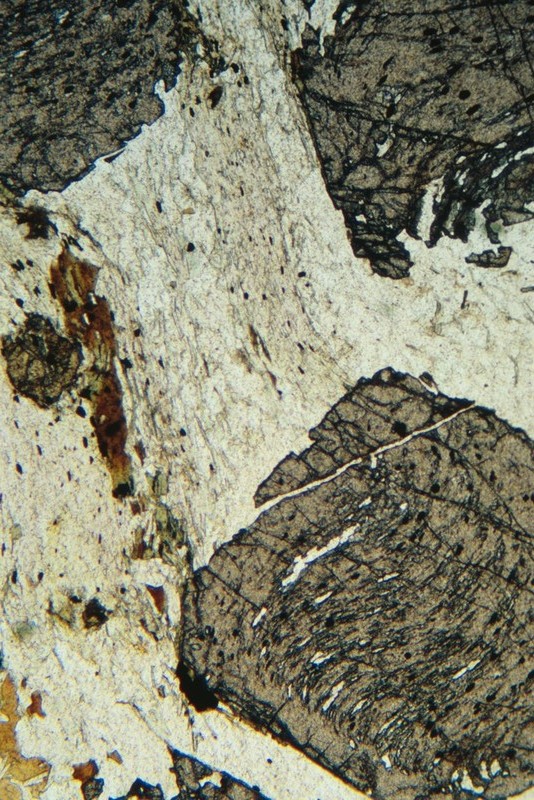
Photomicrograph of garnet-mica schist. Image courtesy of British Geological Survey Geoscenic archive

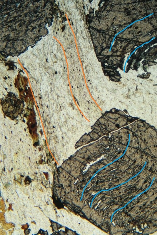
The image above is of a deformed schist. The large grey lump is a garnet crystal, a porphyroblast that grew during metamorphism. Look at it like a structural geologist – what do you see? I see this:

bgs garnet inclusion annot

The orange lines show a fabric within the main body of the rock, visible in aligned quartz and mica. This is likely to correspond to the fabric visible in a hand specimen of the rock. In blue I’ve sketched a fabric visible only in the garnet. As the garnet grew it swallowed up fragments of quartz and other minerals that were themselves flattened into a fabric. This older fabric is now preserved only in the rigid garnet. Outside the older blue fabric has been destroyed, partly by metamorphic recrystallisation, partly by a later deformation phase that squashed the minerals to form the orange fabric

Wider implications

Looking at thin sections allows us to find fine structures that may no longer be visible in an outcrop or a hand specimen. It also let’s us link metamorphic and structural histories together. In our thin-section example the garnet (or at least its core) was growing while the older structure still existed, that is before the later orange deformation episode. If we found a mineral that grew across the orange fabric, it is probably younger than it.

I hope you can see that this allows us to build up two mutually-supporting sequences of events, the structural and the metamorphic. Metamorphic events are sometimes referred to as M1 and M2 and correlated with deformation events. Once you’ve done this, its possible to start linking D and M numbers to tectonic events: an arc colliding with a continent, for example.

Careful now!

Discovering one fold twisting another is an observation. Talking about D1 and D2 and then correlating that with rocks kilometres away is an interpretation. Geologists are excellent at carefully turning multiple observations into rigorous interpretations, but there are various reasons to treat them with care.

The first one is that modern models of mountain building processes (where many deformed rocks form) emphasise gradual processes. The continuous readjustment of an orogenic wedge, maybe switching into channel flow and out again, all this predicts a bewilderingly complex sequence of events for the whole orogen. The second related issue is that a single outcrop may not preserve the entire structural history. Structural and metamorphic processes will not affect an entire mountain belt at once – deformation and metamorphism may be focused into particular areas (perhaps rich in heat and water) and leave the surrounding rocks untouched. Maybe correlations of deformation episodes over wide areas are simply wrong. Maybe ‘D2’ is consistently a strong deformation followed by ‘D3’ folding, but these events happened at different times in different places?

There’s an analogy here with the study of separate sedimentary basins. In the absence of dateable fossils, the age of a sedimentary basin may be poorly known. Even so, geologists will attempt to correlate separate basins based on events preserved in the rocks – we’ve got to do something, even if we know the correlations may be incorrect. If a dateable fossil is found, it may show us we’ve made a mistake, but more likely the sedimentary history and correlations will make the fossil more useful. It doesn’t just tell us the age of a particular layer, but by inference it can illuminate the history of a much wider suite of rocks.

Within deformed metamorphic rocks, we can’t use fossils, but we can use the isotopes within minerals to tell us the age of events. For a while we’ve been able to do this accurately for zircons, but recently we can also directly date metamorphic minerals. Sometimes, for example in Connemara, the metamorphic dates are consistent with a single sequence of structural and metamorphic events that can be linked to arc-continent collision. However increasingly detailed studies of many areas are finding that apparently similar fabrics were formed in different mountain-building episodes, millions of years apart. Single grains of garnet have been found that contain a core that grew hundreds of millions of years earlier than the rim1

The concept of deformation sequences, as a set of observations, is invaluable for linking a particular isotopic age to a wider tectonic context. To say that a particular mineral grain grew at a particular time is not in itself very interesting. But it seems that interpreted correlations of D numbers without isotopic dating should be treated with care.

I’ll be illustrating these concepts with a specific example in my next post on the great Dalradian D2-D3 controversy and my part in it.

References

Argles, T., Prince, C., Foster, G., & Vance, D. (1999). New garnets for old? Cautionary tales from young mountain belts Earth and Planetary Science Letters, 172 (3-4), 301-309 DOI: 10.1016/S0012-821X(99)00209-5
Tanner, P., & Shackleton, R. (1979). Structure and stratigraphy of the Dalradian rocks of the Bennabeola area, Connemara, Eire Geological Society, London, Special Publications, 8 (1), 243-256 DOI: 10.1144/GSL.SP.1979.008.01.25

Cornwall: tin, pasties and the world

The county of Cornwall is like England’s foot, stretching out languorously into the warm waters of the Gulf Stream1. Now a relatively poor area, best known for fishing and tourism, it has a proud industrial past based on mining, notably of tin. Once the most important thing about Britain, Cornish tin is now distributed across the world. The up and downs of mining also scattered Cornish miners globally. If you look in the right places in the right ways, traces of both can still be found.

If you took a chunk of rock and analysed it, atom by atom, you’d find most elements inside it somewhere. In order to have a rock that is an ore, of interest to miners, it must contain enough of what you want so that it can be extracted commerciallyTherefore the formation of ore deposits is often associated with processes that take specific elements from large volumes of rock and put them into much smaller volumes. Granites, which are common in Cornwall, are good at doing this. As granite intrusions cool, water that was within the magma, or from the surrounding rocks, is heated and flows widely. Hot water is good at dissolving and transporting certain elements. At some point this hot water cools and the elements dissolved within it are precipitated out, often into fractures called veins. In places around the Cornish granites there are veins rich in cassiterite – tin oxide.

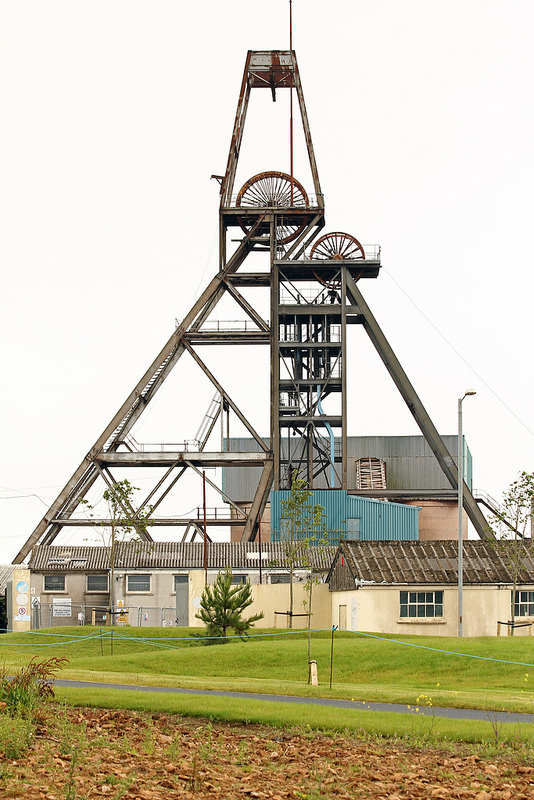
South Crofty Tin mine in Cornwall. Phone from exnottsminer under CC

South Crofty Tin mine in Cornwall. Photo from exnottsminer under CC

Cornwall’s tin travels far

The Bronze Age (in Europe 3000 BC to 500 BC) saw extensive trade networks develop across Europe. The technology of smelting copper and tin to form a durable alloy is first seen around the copper deposits of Cyprus. The warm Mediterranean world had few tin deposits, forcing them to trade with cold barbarian lands to the North. We know that from 2000 BC tin mining started in Cornwall, initially focusing on alluvial deposits (river gravels containing ore).

The Phoenicians, a now vanished pre-Roman civilisation in North Africa, traded directly with Cornwall. The name “Britain” comes from the Phoenician name “Baratanac”, meaning “Land of Tin”. The Greek historian Herodotus, who is the source for much of the little we know about the ancient world, describes how tin comes from the Cassiterides, ‘lands of tin’ that sat beyond Gaul (France). [See comment below for an informed correction of this paragraph] It’s thought that the Phoenicians, who managed the trade, might have been a little cagey about the exact whereabouts of this economically valuable land.

When great military powers invade far-off lands, there are always people who say that their true motivation was to get access to valuable natural resources. We don’t know of any ancient Romans waving banners saying ‘No Blood for Tin’ when Julius Caesar invaded Britain, but modern historians have suggested Cornwall’s tin deposits were a motive.

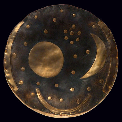
Given the lack of documentary sources for these ancient periods of history, its obvious that archaeology has a role to play. A recent paper used the black arts of isotope chemistry to study ancient tin. The isotopes within metals can be used to uniquely characterise where they came from2: the different geological settings leave a distinctive isotopic signature. Despite having an impressive 10 different isotopes it’s proved relatively difficult to do this with tin, but the authors have shown that a Bronze Age artifact in central Europe (the “Himmelsscheibe von Nebra” or sky disc of Nebra) contains tin  from Cornwall.

Bronze Age metal disc from Germany, containing Cornish tin. Image from Wikipedia

Bronze Age metal disc from Germany, containing Cornish tin. Image from Wikipedia

Another recent scientific study looks at Cornish bogs. By studying metal concentrations in layers within the bog, they can trace when mining was active. Local smelting would spread tin through the environment to be captured in the bogs. From this evidence they suggest that there was only a little mining before the Roman period and that the arrival of the Romans, with their Southern European work ethic and trading mindset3 greatly increased the rate of mining.

To get this direct evidence of the ancient movements of Cornish tin takes big machines run by dedicated scholars. Evidence of the movement of Cornish miners in the Nineteenth Century is easier to find, and tastier too.

Pasties – a world tour

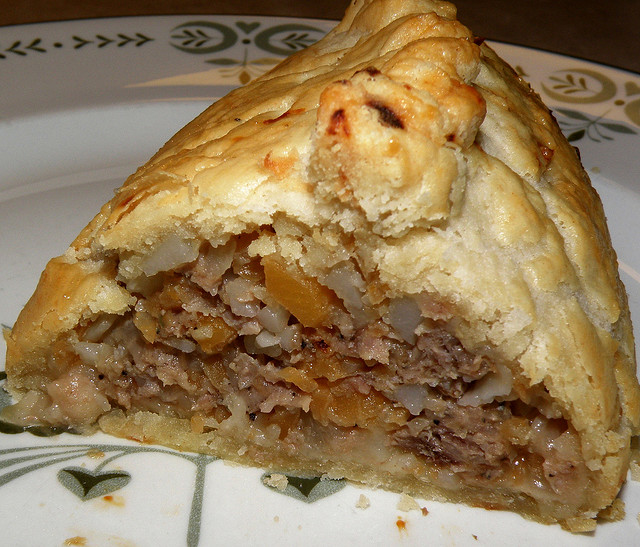
The Cornish pasty, now protected by the full might of European Law, is a folded and crimped pastry circle containing beef, potato, onion and swede. It was popular with the tin miners, as it was a convenient meal that could be eaten with dirty hands.

Cornish pasty. Image from Hammer 51012 under CC as I couldn't be bothered to take my own picture of one.

Cornish pasty. Image from Hammer 51012 under CC as I couldn’t be bothered to take my own picture of one.

The potato reminds us that this is not a Bronze Age dish. In many ways the pasties heyday was the Nineteenth Century, which was also a big time for Cornish mining. By this time all the surface ore had been found and miners were digging down deep, following the veins into the earth. Mining in Cornwall had its peak in the early 19th Century. The Royal Geological Society of Cornwall was founded in 1814 and is the second oldest in the world. Mining terms such as vug and gossan are Cornish in origin.

The mid-Nineteenth Century saw Cornish mining start on a slow but terminal decline as massive deposits were opened up in Bolivia and East Asia. As work dried up, tens of thousands of Cornish miners emigrated to new mining districts across the world, where their skills were in great demand. A Cornish saying of the time said that “a mine is a hole anywhere in the world with at least one Cornishman at the bottom of it!”4

Some went to America. The Californian gold rush of 1850s attracted many Cornishmen and Cornish Pasties are still found for sale in the Sierra Nevada to this day. Others went to the iron and copper districts of northern Michigan and also left pasties behind5.

They reached South Africa and Australia, but also non-English speaking countries such as Mexico and Brazil. They are credited with bringing football (“soccer”) to Mexico and also the ubiquitous pasty. Mexicans may add hot chili sauce to theirs, which would be frowned on in Penzance, but they did open the world’s first Cornish Pasty museum in 2011.

The business of mining and the shipping of raw materials is not glamorous, but it is important. Our civilisation depends on technology that needs particular materials, whether the tin in a Bronze Age sword or the rare metals in your mobile phone. Written histories, often created by politicians or the winners of wars, sometimes overlook the importance of such lowly matters. The study of objects, whether metallic or cultural, can help redress the balance a little.

The Grampian / Taconic orogeny in Ireland – when arcs attack

Ever since the plate tectonic paradigm-shift of the 1960s, geologists have strived to understand ancient rocks in terms of the movements of plates. The geology of north-western Ireland can be explained by what happened when a subduction zone ran out of oceanic crust back in the Ordovician. Let me take you back to before that happened.

Imagine you are floating in the sea. In 480 million years time the crust below will be in Ireland. The sea is warm – CO2 levels are high and you are fewer than 30° south of the equator. Apart from cheeky trilobites nibbling your toes, it is an idyllic place to be. You are near a large land-mass. It’s barren looking  – plants are just about to learn how to survive outside the sea 1 so there is little to soften the landscape. The tumbler of gin and tonic2 you clumsily dropped has sunk into sediment that will one day be part of the Dalradian Supergroup.

Your mood has soured. Not only has your drink gone, but you’re getting creeped out by the cloud on the horizon out to sea. It’s not a fluffy, friendly one but a dark spreading plume of volcanic ash. Far out to sea, there is a line of volcanoes and they spell D-O-O-M for the peaceful spot you’ve found. Every year the volcanic arc gets a little bit nearer. Eventually it will smash into the continent behind you, grinding over the top. The peaceful sand and mud washing around below your feet will be sediment no more. The collision between the volcanic arc and the continent will transform the Dalradian sediments into the contorted metamorphic rocks that today make up much of NW Ireland.

An accident waiting to happen

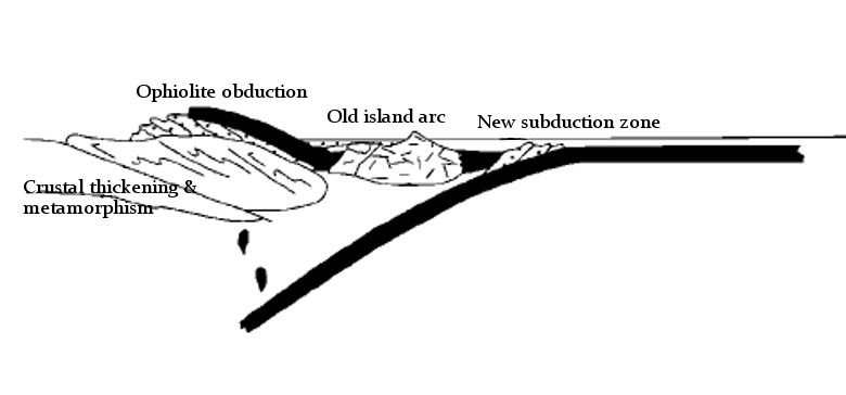
Here’s a diagram showing a section through the land below. Black is oceanic crust, yellow stippled is sediment3.

x-section 1 geo labels

Let’s start from the left. Notice that the edge of the continent is thin and tapering – it was stretched out when the ocean basin formed. The oceanic crust attached to the continent is being stuffed down back into the deep earth. As it sinks, it is squashed and heated, starting a complex process that ends with molten rock reaching the surface. Over time this magma has formed a volcanic arc, a small piece of thickened crust.

This situation can’t last for ever. Once all of the oceanic crust of the lower plate has run out, normal subduction comes to an end. The upper plate slides over the thinned continental margin and ends up lying on top of the continent – a process called obduction. The island arc and forearc basin are squashed against the continent. Like a bulldozer hitting a pile of sand, the arc collision compresses and thickens the crust. The Dalradian sediments become thoroughly deformed and heated and are now a wildly complex set of schists and marbles.  This process creates a mountain belt, an event known as the Grampian orogeny.

As shown in the diagram below 4, the orogeny does not stop plate convergence. The old subduction zone has been destroyed, but another one is created in the opposite direction. This process, called ‘subduction flip’ changed the tectonic stress regime; it’s believed to have led to a process of ‘orogenic collapse’ whereby the thickened crust extends and thins, bringing metamorphism to an end. The overall tectonic event was remarkably quick, around 15 million years.

x-section 2 base

Where are they now?

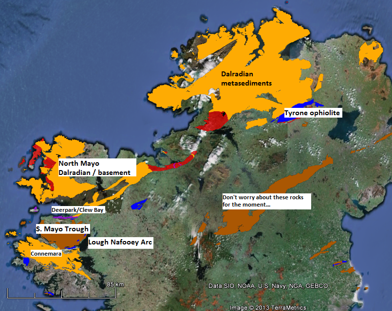
This type of orogeny can be recognised as it leaves distinctive rock types behind. Ophiolites, pieces of oceanic crust within continents are found in several places in Ireland; the largest example is the Tyrone ophiolite, but traces of oceanic crust can also be found in Mayo, near Westport, in the Clew Bay and Deerpark Complexes. The story goes that there are no snakes in Ireland because Saint Patrick, while fasting on top of Croagh Patrick, threw them down into Clew Bay. That the sea-facing side of the mountain contains a lot of green serpentinite suggests the origins of the story have a geological angle5.

ireland grampian map

Map of NW Ireland. Red – continental basement, Yellow-Dalradian, Blue – lower-mid Ordovician volcanics, Brown – Ordovician sediments, purple serpentinite & melange. Data from Geological Survey of Ireland, displayed using Google Earth

Parts of the volcanic arc can now be found around Lough Nafooey, just to the south of the South Mayo trough, which corresponds to the fore-arc basin. The Dalradian sediments and underlying older crust make up most of the land to the north west of these rocks.
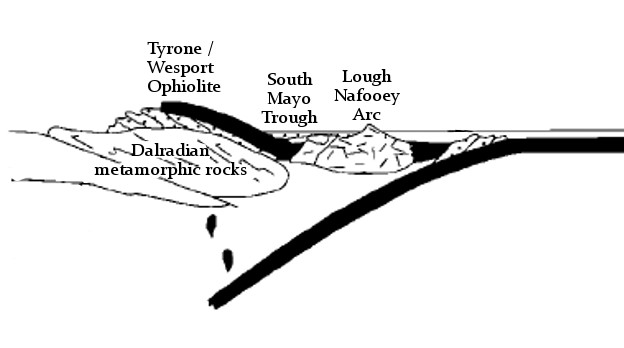
Let’s revisit the cross-sections, labelling the modern day equivalents. Before the collision:

x-section 1 geograph labels

and immediately afterwards:

cross section of Grampian orogeny

A wider context

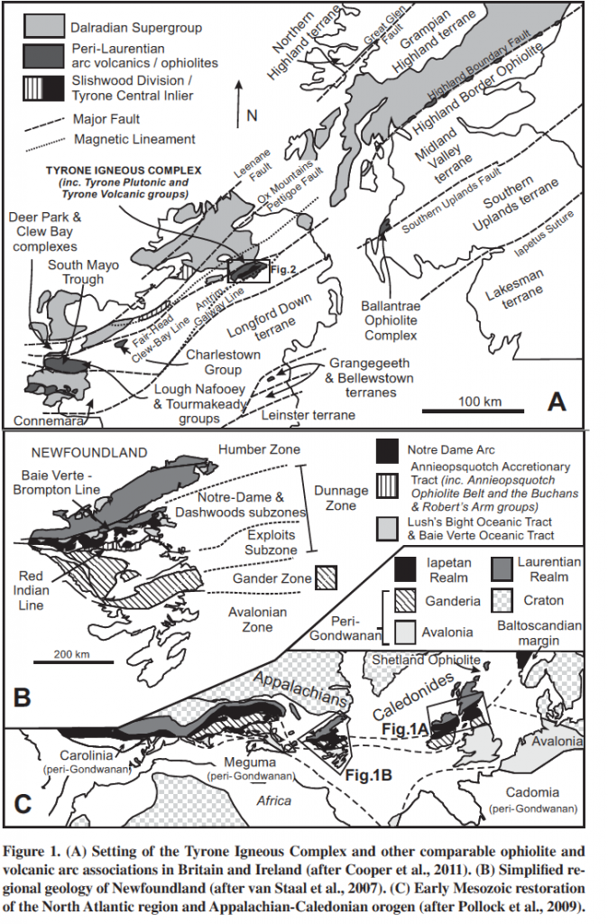
Ireland was only a small section of a continental margin that stretched from rocks now in Greenland down into the eastern US and Canada. The Grampian orogeny also affected Scotland and the same arc-collision event is found in eastern Northern America where it is known as the Taconic orogeny. 

Figure 1 from Hollis et al. 2012

Figure 1 from Hollis et al. 2012

Recognising the connection across the Atlantic helped geologists understand the causes of these complicated patterns in the rocks – different sections show different parts of the orogeny and synthesising research across a wider area leads to a richer understanding. The patterns are complex – more so than I’ve shown above. There were probably multiple ‘accretion events’ where different arcs collided at different times. The pattern of plates in modern day SE Asia is seen as an analogy here – they may have been multiple subduction zones and arcs within the wider ocean.

Geological is 4-dimensional, and the Grampian/Taconic orogeny reminds us of this. The timing of the various accretion events varies because the edge of the continent was not straight. Promontories (sticky-out bits) were hit by the arc sooner than parts where there was more oceanic crust to be consumed. Another complication is that continents don’t break cleanly: fragments of continental crust can end up far from the main continent (for example Rockall in the Atlantic). The arc whose collision caused the Grampian orogeny in Scotland (now found buried in the Midland Valley) is thought to sit on continental crust.

These 15 million years were a very important time for the crust of the northern half of Ireland, but are only a small part of the wider geological history of Ireland. I’ll leave the story unfinished here and tell you what happened when the new subduction zone ran out of oceanic crust in future posts.

References

RYAN, P., & DEWEY, J. (1991). A geological and tectonic cross-section of the Caledonides of western Ireland Journal of the Geological Society, 148 (1), 173-180 DOI: 10.1144/gsjgs.148.1.0173
Hollis, S., Roberts, S., Cooper, M., Earls, G., Herrington, R., Condon, D., Cooper, M., Archibald, S., & Piercey, S. (2012). Episodic arc-ophiolite emplacement and the growth of continental margins: Late accretion in the Northern Irish sector of the Grampian-Taconic orogeny Geological Society of America Bulletin, 124 (11-12), 1702-1723 DOI: 10.1130/B30619.1
Bird, A., Thirlwall, M., Strachan, R., & Manning, C. (2013). Lu-Hf and Sm-Nd dating of metamorphic garnet: evidence for multiple accretion events during the Caledonian orogeny in Scotland Journal of the Geological Society, 170 (2), 301-317 DOI: 10.1144/jgs2012-083

Scandinavian crust now in Alaska!

The face of the earth is ever changing. Plate tectonics is slowly but surely rearranging the locations and inter-connections of continents. However knowing this in the abstract doesn’t prepare you for the awed surprise of discovering that a section of crust formed in Scandinavia is now found in Alaska.

The evidence for this comes from a massive accretion of data from geologists across the world. Build up a geological history, underpinned by accurate dating, for enough parts of the world and you can start correlating ancient events. Other tools area palaeomagnetic studies that can tell the you the latitude of a piece of crust at a given time and suites of fossils that trace small areas where organisms with local characteristics were found.

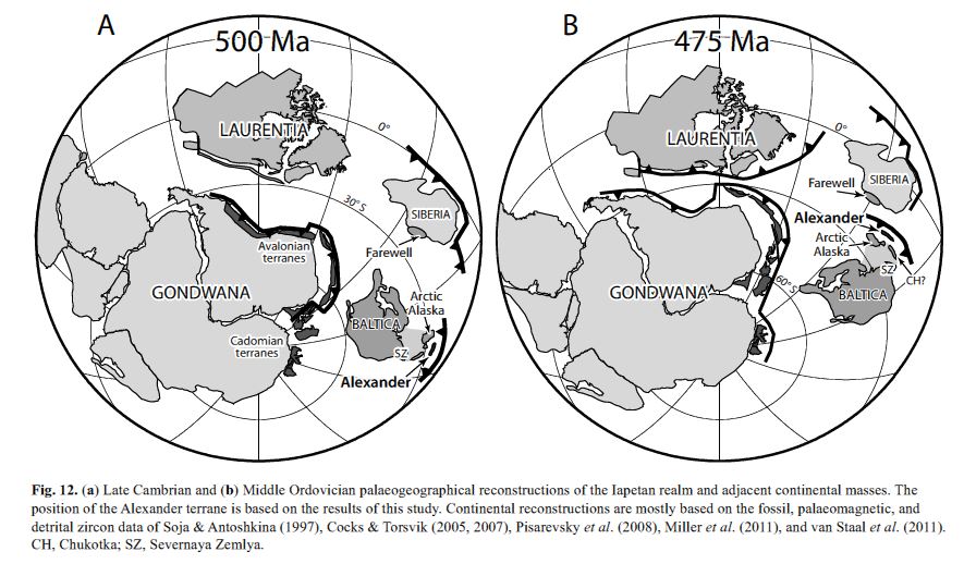
The latest research (Beranek et al. 2013) uses most of these techniques to nail down the link between a portion of Alaska and rocks now in Northern Scandinavia. It’s long been known that Alaska and Pacific Canada is made up of portions of crust (terranes) that formed elsewhere. The portion in question, the Alexander terrane is not small, covering 100000 km2 from British Columbia up into Alaska. Here’s where they reckon this crust was half a billion years ago:

Figure 12 from Beranek et al. 2013

Figure 12 from Beranek et al. 2013

The area labelled Laurentia corresponds to North America today, Baltica to Scandinavia. Arctic Alaska and Farewell are other terranes now found a long way from home. If you’ve read my post about rotating continents, you’ll have spotted the way Baltica dramatically swings round.

How did these terranes get round to the other side of Laurentia/North America?

Figure 11 from Colpron & Nelson 2009.

Figure 11 from Colpron & Nelson 2011. AX = Alexander terrane

This figure from Colpron & Nelson (2009) shows how. We are 50 million years further on from above. Baltica and Laurentia are now fused together, the ‘Caledonides’ – a strip of fascinatingly deformed rocks – mark where they collided. The  narrow subduction zone to the north of this area will over time pull itself forward, dragging the continental fragments over the top of Laurentia. A similar process is going on today in the Caribbean, where the Caribbean Arc is moving east, pulling ‘Pacific’ rocks further towards the Atlantic Ocean.

Ultimately these fragments end up plastered onto western Northern America in the area known as the Cordillera, waiting for cunning geologists to spot their true origins. I don’t know about you, but my flabber is well and truly gasted by this, by both the fact that it happened and that we can work out that it did so.

Colpron, M., & Nelson, J. (2009). A Palaeozoic Northwest Passage: incursion of Caledonian, Baltican and Siberian terranes into eastern Panthalassa, and the early evolution of the North American Cordillera Geological Society, London, Special Publications, 318 (1), 273-307 DOI: 10.1144/SP318.10
Beranek, L., van Staal, C., McClelland, W., Israel, S., & Mihalynuk, M. (2013). Baltican crustal provenance for Cambrian-Ordovician sandstones of the Alexander terrane, North American Cordillera: evidence from detrital zircon U-Pb geochronology and Hf isotope geochemistry Journal of the Geological Society, 170 (1), 7-18 DOI: 10.1144/jgs2012-028