The South Mayo Trough: tiny grains record huge events

Sedimentary basins have been described as ‘tape recorders’1 that preserve evidence of past events. Some sedimentary basins contain ‘recordings’ of grand tectonic events – plate collisions and mountain building. The information is stored as subtle but compelling patterns in the type of sand grains. Combined with studies of linked metamorphic and igneous rocks, they allow us to form a very rich understanding of past – to ‘listen in’ to dramatic stories from earth history.

Sandstones are made of sand, that has become stuck together to make rock2. These sand grains come from the breakdown of rocks that no longer exist. Whole mountain ranges are brought low by slow everyday processes. The mountains may be gone, but the stuff they were made of remains, as humble sand.

Most sand grains are overwhelmingly made up of quartz, followed by feldspar and fragments of rock. Other types of grain are there, but they make up a tiny proportion of the rock. To study these less common grains, geologists bash the sandstone back into sand and pour that into a heavy liquid. The common grains float to the top and many of the rarer ones sink. Geologists can then separate out the ‘heavy minerals’ and identify them under a microscope.

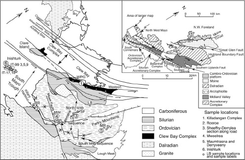
A dramatic example of the usefulness of heavy minerals comes from Ireland’s South Mayo trough. This area of Ordovician volcanic and sedimentary rocks sits within a complex collage of rocks shuffled around by the Caledonian orogeny. It is broadly a syncline in shape, with two sets of outcrops – a northern and a southern limb.

Location of South Mayo Trough. Figure 1 from Mange et al 2010

Location of South Mayo Trough. Figure 1 from Mange et al. (2010)

Today, the South Mayo Trough sits within the Eurasian plate, but it was born in the middle of an ocean that no longer exists.

All at sea

The oldest sediments are found in the Letterbrock formation3.  The sediment matches what you would expect from erosion of the rocks found immediately north of the basin, the Killadangan formation which has been interpreted as an accretionary prism.

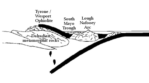
In the south, the sediments correlate with the Lough Nafooey group of volcanic rocks. These formed as part of an oceanic island arc within the Iapetus ocean. Together, this evidence suggests the South Mayo Trough formed as a forearc basin.

South Mayo Trough forming within the Iapetus ocean

South Mayo Trough forming within the Iapetus ocean

The oldest sediments in the north also includes ‘ophiolite detritus’ – grains such as epidote and chromite that are typical of the erosion of oceanic crust. In the overlying Derrymore and Sheefry the ophiolitic debris becomes dominant – serpentine and chromite are so abundant that some beds are unusually heavy and have a ‘soapy’ feel. The volume of chromite increases up through the Sheefry and its chemistry becomes richer in Cr/Ni/Mg. 

Grains of mica and zircon in these rocks have been dated. They show a variety of ages, all Precambrian, consistent with being derived from the old rocks of the Laurentian margin.

During this time, the volcanic rocks of the south show a change in composition. The earliest rocks are basaltic. Patterns of rare earth elements and other geochemical signatures are consistent with an oceanic island-arc origin (only oceanic crust involved). Over time the rocks become progressively more acidic, moving into andesitic and ultimately rhyolitic compositions. Rare earth elements show that the tectonic environment changes. Initially the oceanic island arc magmas were formed from melting of oceanic crust only. Progressively, more and more melt is derived from melting of Laurentian continental crust.

Collision but no mountains

The volcanic rocks therefore record that subduction zone has run out of oceanic crust – the island arc has collided into the continent – the leading edge of which was subducted and melted to feed the volcanic arc.

At the same time as these events recorded in the South Mayo trough, sediments formed on the edge of the Laurentian continent  the Dalradian Supergroup) were being buried, heated and deformed in Grampian/Taconic orogeny. The sediments were buried underneath the oceanic crust (ophiolite) and oceanic island arc as they collided with the continent.

South Mayo trough as part of arc-continent collision

South Mayo trough as part of arc-continent collision

This implies the South Mayo trough itself was part of the upper plate, thrust onto the continent. The work orogeny is synonymous with mountain building, but here we have a sedimentary basin sitting on top of an orogeny, not only being preserved, but continuing to fill up with sediment. Various explanations have been given: the subducting slab and the ophiolitic upper nappe may have been unusually dense. The sedimentary basin, packed with serpentine and chromite certainly was. The sea-level at this time (mid-Ordovician) was unusually high, between 250-500m higher than at present. It’s possible the South Mayo trough was only plastered onto the side of the orogen, not thrusted completely over the top.

Whatever the reasons we should certainly be grateful that the sedimentary tape recorder was preserved. It was still rolling and about to record some more remarkable events.

A  change of direction

Plate tectonics is a global phenomena. The closure of the subduction zone and the arc collision did not stop the overall convergence between the Laurentian continent and the Iapetan oceanic crust. In time another subduction zone formed, this time putting oceanic crust underneath the continent – a change of direction.

While this flip of subduction was taking place, conditions in the South Mayo trough at first didn’t change. The Lower Derrylea formation contains ophiolite debris from north (chrome spinel and purple zircons) and arc debris (clear zircons) from the south.

Diagram showing links events in the South Mayo Trough and other areas. Supporting Appendix. Key to columns: A, Western Newfoundland Ordovician Shelf; B, Notre Dame Bay arc stratigraphy; C, West Newfoundland ophiolites; D, Notre Dame arc ages; E, Quebec.New England; F, Scottish Highlands; G, Achill; H, Connemara; I, Clew Bay Complex; J, Scottish ophiolites; K, north limb of SMT; L, south limb of SMT (thicknesses in K and L in meters), detrital mica ages [71] in SMT; M, Derryveeny; N, Mweelrea; O, Derrylea; P, Rosroe; Q, Maumtrasna; R, Sheefry; S, Southern Uplands accretionary prism; T, detrital mica ages [70] in Southern Uplands accretionary prism.

Diagram showing links events in the South Mayo Trough and other areas. See Dewey (2005) for detailed explanation

Suddenly, around 466 million years ago, while the upper Derrylea formation was being deposited, a massive change occurs. Starting with a single massive thick turbidite bed there is an influx of different heavy minerals. In comes staurolite, almandine and chloritoid, along with floods of muscovite. These are metamorphic minerals and they show Ordovician ages – they come from the metamorphic rocks of the Dalradian.

Dating of these minerals shows that they were hot only 5-10 million years before they ended up as sand grains. Such rapid unroofing of metamorphic rocks suggests something more potent that erosion is at work. The Dalradian rocks in this area show rapid cooling at this time also suggesting something was bringing them rapidly towards the surface. What tectonic mechanisms could explain this?

With the creation of a new subduction zone to the south, the force of the converging plates was no longer supporting the thickened rocks of Taconic/Grampian orogeny. Now in a back-arc position, they extended rapidly. Major faults rapidly brought deep rocks to the surface sending metamorphic minerals cascading into the South Mayo Trough.

Once the Dalradian debris starts flowing, there are no more dramatic changes in the recording. It ends fairly soon after – the whole area is covered by unconformable Silurian sediments – but there is one more thing.

By 464Ma, the whole area is now in an ‘Andean’ type of tectonic environment, with intermediate vulcanism associated with the new subduction zone. This is recorded as ignimbrite layers in the South Mayo Trough, but also as granite intrusions within the nearby Connemara terrane. Once more we are able to make links between the surface and deep processes.

This is what makes these techniques and these rocks, so special. Linking surface to deep processes, resolving timescales to within a million years – these are very powerful ways of understanding how the earth really works.

References

Dewey J.F. (2005). Inaugural Article: Orogeny can be very short, Proceedings of the National Academy of Sciences, 102 (43) 15286-15293. DOI:
Mange M., Idleman B., Yin Q.Z., Hidaka H. & Dewey J. (2010). Detrital heavy minerals, white mica and zircon geochronology in the Ordovician South Mayo Trough, western Ireland: signatures of the Laurentian basement and the Grampian orogeny, Journal of the Geological Society, 167 (6) 1147-1160. DOI:
Brown D., Ryan P.D., Ryan P.D. & Dewey J.F. (2011). Arc-continent collision in the Ordovician of western Ireland: stratigraphic, structural, and metamorphic evolution, Arc-Continent Collision, 373-401. DOI:

Fracking great science from the British Geological Survey

Fracking is rightly a major political issue. In Britain this is topical as the government has just released a technical report showing that very large volumes of natural gas are locked into rocks beneath northern England. As a tax-payer whose house is heated and food cooked using gas, but who is concerned about CO2 emissions and climate change, I will be directly affected whether we extract this gas or if we leave it be.  But what interested me about the report was not politics, not energy policy, but a genuine pride in the quality of unbiased scientific data contained within it. Politics can wait. Let’s celebrate the vast data sets and clear and comprehensive analysis that I’m glad my taxes have paid for.

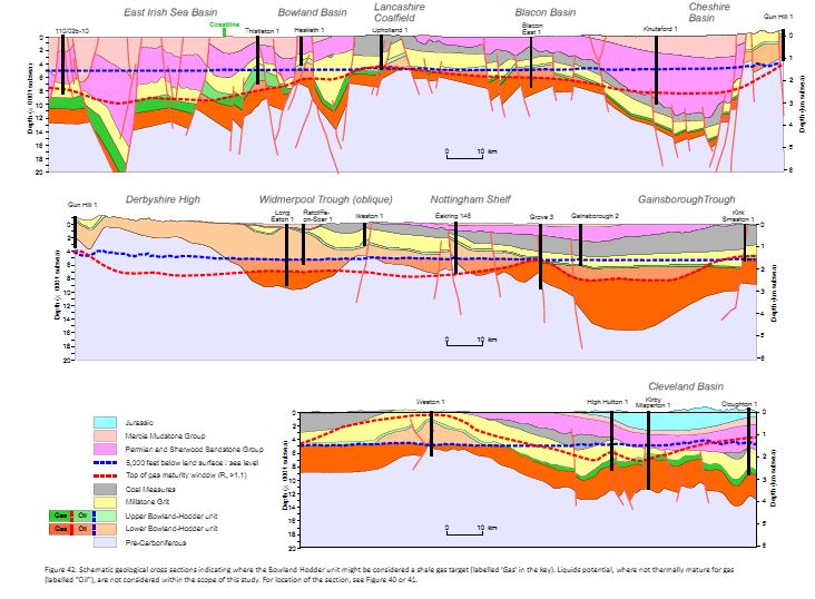
Figure 42, schematic cross sections of the north of England. Copyright DECC 2013

Figure 42, schematic cross sections of the north of England. Copyright DECC 2013

The report sits in a clean and fast web-page, linking to downloadable reports that include a vast amount of data. It’s copyrighted, but I can copy images into here, with attribution. There’s even an apologetic note that ‘users of assistive technology’ may not be able to make use of the files.  This is how all government websites should be.

The study focuses on a particular geological unit that covers much of the north of England, the Bowland-Hodder shale. For a geological introduction, I can’t better the report itself: “Marine shales were deposited in a complex series of tectonically active basins across central Britain during the Visean and Namurian epochs of the Carboniferous (c.347-318 Ma). …. The marine shales attain thicknesses of up to 16,000 ft (5000m) in basin depocentres (i.e. the Bowland, Blacon, Gainsborough, Widmerpool, Edale and Cleveland basins), and they contain sufficient organic matter to generate considerable amounts of hydrocarbons.” 

The study identifies draws on a mass of seismic and borehole data and distinguishes two horizons, an upper and a lower. The upper is a post-rift deposit that resembles “prolific North American shale gas plays”. The lower is less well known (not much drilling information) but was deposited during the rifting and so is a thicker deposit. Here’s a sense of how much data they are  drawing on:

Figure 8. Copyright DECC 2013

Figure 8. Copyright DECC 2013

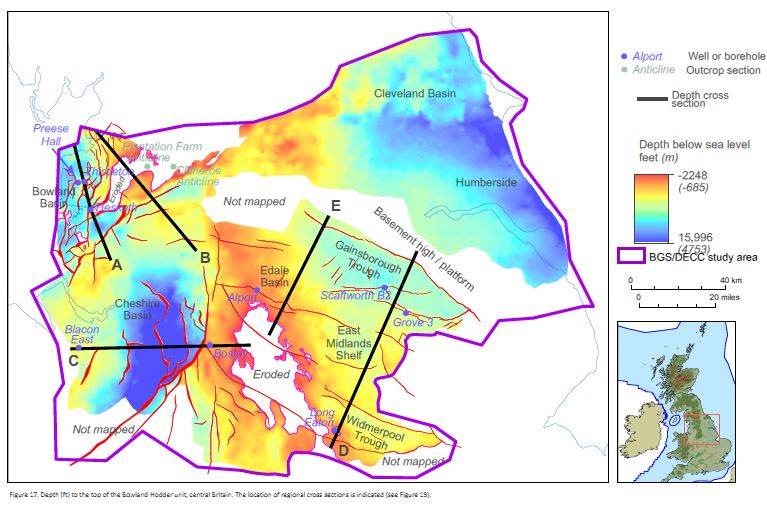
Seismic data gives you a cross-section view through the sedimentary layers. Borehole data allows you to link the layers to actual rocks. Gamma ray logging data allows you to estimate the amount of organic matter within these rocks. The report tells you how the deep the shale is:

Figure 17. Copyright DECC 2013

Figure 17. Copyright DECC 2013

It has other pretty maps showing how thick the layers are, plus lots of cross-sections.

These rocks started as mud with organic matter in them. This only turns into valuable oil or gas once that organic matter has been buried and heated. The shininess of woody matter from boreholes (called vitrinite reflectance), records how much the rocks have been heated. Particular values of vitrinite reflectance correspond to a ‘gas window’ indicating that shales with organic matter are likely to contain methane gas.

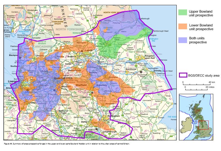
Putting all this data together, the British Geological Survey guys have produced maps of areas where the upper and lower units exist and have passed through the gas window.

Figure 44. Copyright DECC 2013

Figure 44. Copyright DECC 2013

What the man in the street wants to know is: how much gas is there? The study uses a Monte Carlo analysis of the various parameters to come up with an estimate. In layman’s terms, there is an enormous amount – around a quadrillion cubit feet. Even allowing for the fact that fracking can only extract a small proportion, the amounts are easily comparable with the conventional gas reserves already extracted from the North Sea.

I’ve barely scratched the surface of the data contained in these reports. I’m sure there are many geologists employed by industry studying them intently, but note that as far as I can tell, all of this data is provided by the British Geological  Survey. Will this report result in many more holes being drilled into the north of England? Only time will tell.

What makes a view great?

We all know of places we love because we can look out on a wonderful view. But what makes a view special? Sometimes views make great photos – they have combinations of colours, textures and composition that really work. Really great views have something that can’t be captured in a flat image – they have a sense of place, of space, that makes them an experience. The way they make you feel makes you want to come back again and again.

I grew up with a great view. My parents’ house sits on an ordinary road that just happens to sit a few hundred feet above the Cheshire Plain. From the top floor, the view is far from spectacular –  even a skilled photographer would struggle to turn it into a pleasing image (let alone me). But on a normal day you can see across most of Cheshire and Greater Manchester – an area that over 3 million people call home. All of this – the first ever railway line, the lab where Rutherford first split the atom – is below you. If there are clouds (there are always clouds) patches of sunlight pick out different slices of the foreshortened landscape. At night the city glows and flashing sparks descend into Manchester airport. It is endlessly fascinating.

I now live in the south east of England and there is something missing from the views. The scenery is pleasant, but to my eye, something is missing. What?

Maybe it’s height. I’ve yet to meet an English 4 year old, who, when climbing on top of a slide or climbing frame doesn’t chant “I’m the King of the Castle”. Corporate warriors fight for a corner office in a tall building; a good view over the faceless throngs below is a sign of status. When I look down over Manchester, am I just a cat on a fridge, looking down on everybody else?

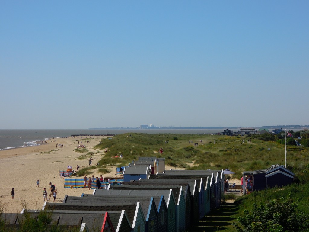
Looking south from Southwold. Sizewell nuclear power station on horizon. Bay in the middle used to contain Dunwich

Suffolk’s big skies

I used to think so, until I went on holiday in Suffolk, a part of the country that is unusually flat. Suffolk has awesome views, precisely because of the lack of height. There is a tremendous sense of space – “big skies”. All it takes is to be 30 foot above sea level and you can see a long long way. The nuclear power stations at Sizewell are a big visual presence, even when they are so far away that the pressurised container of Sizewell B is like a golfball on the horizon. So its not height that makes for a great view, it the sense of space that comes from seeing a long distance.

Confirmation of this came from a trip to Everest Base Camp. This is a landscape turned up to 11. High rates of erosion and rapid uplift go hand in hand, meaning that landslides are a major influence on the shape of the land.  Day to day, trekking is within steep valleys and the views aren’t that good. The mountains are always beautiful, but you can’t see very far and there is no sense of scale. In the right places, the views are amazing, of course.

Take a look at this amazing time-lapse video from Everest.

I’m struck that the views that make me catch my breath are where you can see people in the landscape, like the lights moving up the Khumbu Icefall. Distance needs to be in context to have a real impact. We know the stars are vastly distant but this is hard to engage with emotionally. Realising a tiny dot on a vast ramp of ice is another human being suddenly makes the view come alive.

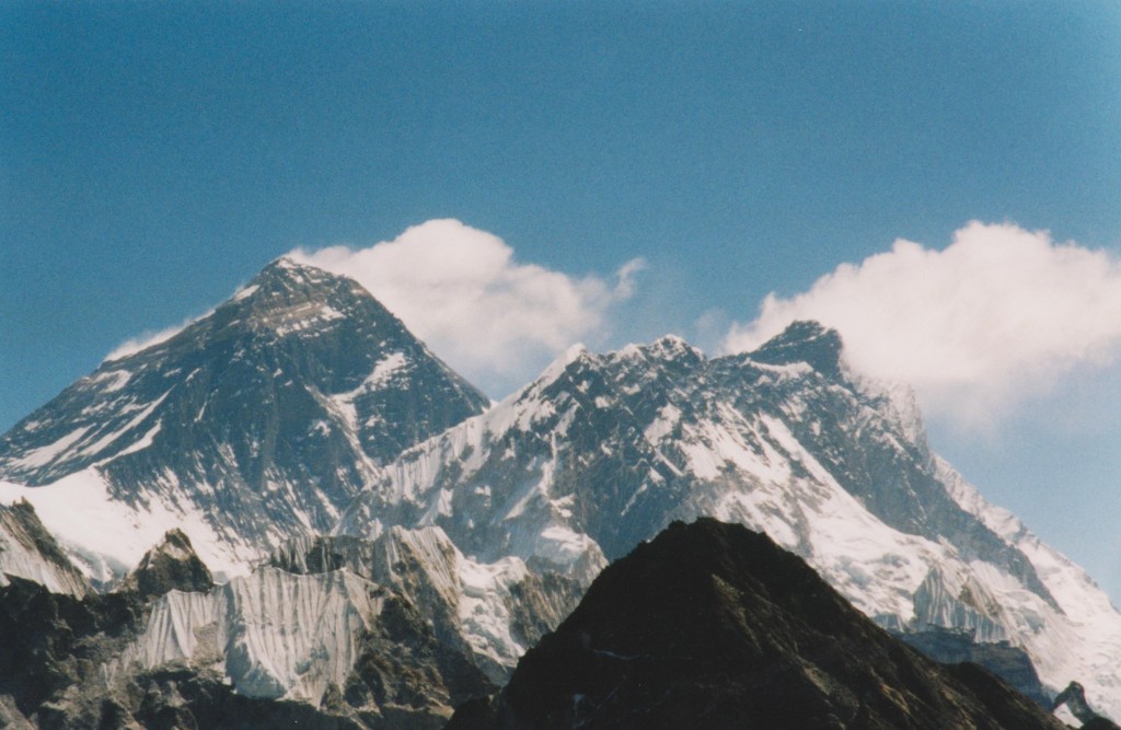
Also, that video contains not one shot of the summit of Everest. From Base Camp it is simply not visible. Views of Everest from the south are usually taken from one of two hills that let you peer over the intervening peaks.

mount everest and nuptse

North of Everest is the relatively flat Tibetan Plateau, where erosion is lower and the crust isn’t being squeezed out, like it is further south. Views of Everest from the north are much better – the foreground doesn’t get in the way. Everest can be appreciated from a proper distance.

Mount Everest from the North. Image under CC from steynard

Mount Everest from the North. Image under CC from steynard

My craving for a sense of space colours my view of places. A great walking holiday in the American west took me to Yellowstone National Park. While loving the geysers and pools, I found my longing for a view into the distance thwarted by the flat topography and all those bloody trees. The Grand Tetons though? Oh my. From within the Park, the view west to the great craggy peaks was the immediate attraction, but I found myself drawn to look east, down the Cambrian dip slopes towards the flat land of Idaho. Who cares if all they do there is grow potatoes? It felt like I could see all the way to the Pacific. Some of the very finest places combine a sense of space that is both horizontal and vertical. Death Valley in California contains huge flat areas, giving all the sense of space that entails and is ringed by big mountains. Everywhere you look, up or along, there is great view.

Despite having seen soon truly massive views, I still love the view from my parents’ house. This is all wrapped up with other associations and memories of course. The best experience was last New Year. Being a parent of young children is like living in different time  zone – you are always a couple of hours ahead of everybody else. Consequently, unable to stay awake, we bailed early from the pub and were back at my parents at midnight. It was a clear night and we soon realised that people have become very keen on the tradition of setting of fireworks at New Year. We got a fine view of about 10 sets of fireworks nearby, but what was really magical was being able to see fireworks across the whole of Manchester. The whole city was covered in a multi-coloured shimmering, constantly shifting, constantly mesmerising. Seeing the same thing both near and far gave a very precise sense of distance. Then we saw lights floating across the sky. They were moving fast, were they small and near or far and impossibly fast? We couldn’t tell. Suddenly a floating paper lantern drifted over the garden, banishing drink-addled thoughts of UFOs.

I got to share all this with my 3 year old son, who happened to be awake. I know he remembers it now. I really hope the memory survives the tremendous changes his brain is going through. The sense of space, the sheer beauty of it – it would make an amazing first memory.

The geology of children’s TV

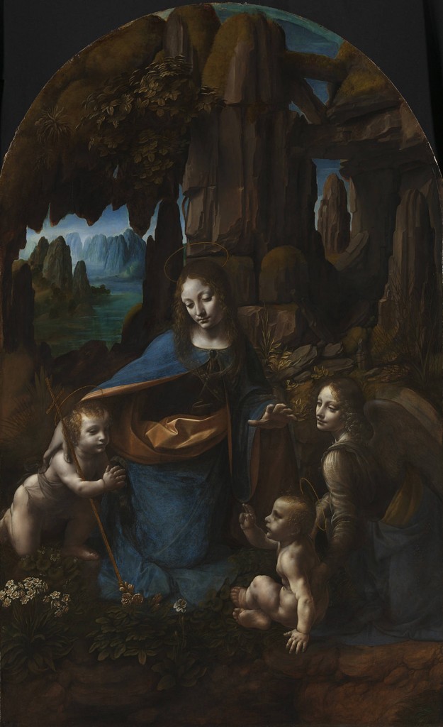
Once my wife and I visited many art galleries and I developed a rule of thumb – the quality of an artist can be assessed by the way they paint rock. If a figurative artist has put an outcrop in the background of their picture, does it look real or as often happens does it show bedding planes but in a random orientation? Some artists accurately capture the shape of an outcrop and I am always pleased when they do. If they get the backdrop right, it suggests a commendable attention to detail. Like with Leonardo da Vinci here.

Leonardo da Vinci's Virgin of the Rocks. Vertically bedded limestone, both foreground and background

Leonardo da Vinci’s Virgin of the Rocks. Vertically bedded grey rock, consistent bedding in both foreground and background. Top right with horizontal bedding could be a fallen block.

I now have young children. Instead of visiting art galleries, I watch children’s TV or read children’s books. The same impulse to critique the geology remains though. Sometimes the artists or animators match Leonardo. Sometimes they make me wince.

Analogue

When drawing for children, I doubt any artist’s first thought is geological exactitude1. If the art is being drawn by hand, even more so. But some children’s literature aims to accurately portray nature. Smiles are wider and more human that in real life, but there is a clear desire to portray a version of the real world.

Take the work of Axel Scheffler and Julia Donaldson:

gruffalo rocks

In the picture above, there is a recognisable beech tree and red squirrel, plus other trees I ought to know the names of. When Axel Scheffler draws animals or plants, they are indentifiable (unless like the gruffalo above they have been brought into existence by a clever mouse’s stories). Sadly the rocks in the picture are grey and featureless, exactly like every other rock in all of his books. Disappointing.

What about film? Take Disney Classic, the Jungle Book. Rocks don’t feature heavily, its true, but when they appear they have the ring of truth about them, which is more than can be said for the vultures from Liverpool.

Jungle Book Baloo looks at Mowgli

I’m writing this post partly because @volcanoclast on Twitter showed me I am not alone:

Volcanoclast

The world of Thomas the Tank Engine has many mysteries, it’s geology is just one of them. I’ll add to Ian’s observations that the cliffs near the beach are bright orange with nice horizontal bedding, which only deepens the confusion.

Digital

Kids nowadays! Don’t know they’re born! When I was a lad, children’s television was ratty models, poorly animated into stories with a broadly communist theme, usually with far too much folk music2. These days they have computer generated images, orchestral music with a rock beat and fast-moving exciting tales of anthropomorphic animals rescuing each other with cool technology.

I, like the rest of my household, like Octonauts a lot. Each animal has a different regional accent to entertain the parents. It has marine biologists advising it and each episode introduces you to a new animal, like the cookie-cutter shark, or the blobfish. One thing: if there is a geological advisor then they should be shot.

The real ocean, is generally flat and made of mud, limestone or basalt. The ocean in which the Octonauts explore, rescue and protect looks nothing like this.

octonauts rocks
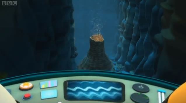
It’s full of canyons, seemingly designed to show off a very odd set of rocks, with wavy inconsistent bedding and odd colours and patterns. This is consistent with the distinctive visual theme and could be forgiven – real penguins don’t constantly say ‘flappity flippers’ either – but the blob fish episode is properly bad. The easily-resolvable-dramatic-tension for this episode comes from rescuing animals from a volcano that is about to erupt. Here’s the volcano:

Octonauts 'volcano'

Octonauts ‘volcano’

Oh dear, oh dear, oh dear.

Moving on, the Pixar ‘Cars’ films have a really lovely and accurate use of rock.

The original Cars is largely set in Radiator Springs, somewhere in the middle of America just off route 66. There are many rocky backgrounds in the film, clearly modelled on two real features of this area. Firstly there are lots of red horizontally bedded sediments, cutely modelled to look like car bonnets (terribly sorry: ‘hoods’). Interspersed are steeply bedded bits, modelled on flatirons but also made to look like the back end of cars sticking out of the ground.

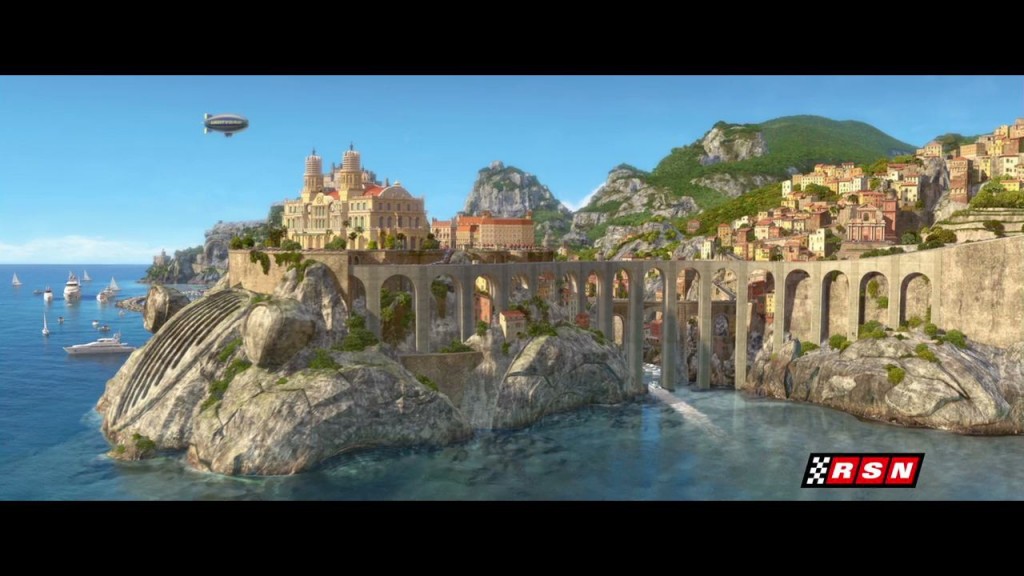
virtuality-pixar-animation-cars-filmCars 2 has some things going  for it – a continuation of the attention to geological detail. Here’s a view of Porto Corsa, a village on the Italian Riviera, clearly built on Tethyan limestone. If only the script had received the same loving care and attention.
cars2_portocorsa_hd

To summarise, can we draw any deeper lessons from the way geology is depicted in children’s entertainments? Should we care more about the way children, future custodians of our precious planet, are shown rocks? No, not really.

I know I’m not alone in checking out the rocky backgrounds my children barely notice. Help me out here: what other examples have I missed?

Disclaimer
I’ve not bothered with my usual scruples about copyright. In the highly unlikely event you own copyright on these images and are bothered about my use of them, let me know and I’ll take them down.