Six amazing facts about what’s under your feet

Just 100s km away from you are right now there is a place where rocks can flow, where once-living matter is turned in jewels, from where deadly plumes once killed nearly all life on earth. We can never visit this place – even though it’s right under you.

1. Human beings will never reach the deep earth

We’ve been to the moon and Mars is almost in our reach but we are never going to the deep earth. The deepest hole ever drilled got just over 12km below the surface – that’s a paltry 0.2% of the 6380km to the earth’s centre. It gets harder to drill the further you go. The rock was already 180°C  when they stopped drilling and it gets hotter as you go down, getting as high as maybe 6000°C (as hot as the surface of the sun).

We could *maybe* send a probe down there. In a paper in Nature, David Stevenson came up with the most plausible plan to date. It involves making a crack in the earth (with a nuclear explosion) and filling it with 100,000 tonnes of liquid iron and a small probe. The probe (might) then sink down to the edge of the earth’s core.  No-one is planning to try this out at the moment, but it would make for an interesting Kickstarter project.

There is a lot of heat in the earth. Consider that scene in Star Wars when the Millennium Falcon comes out of hyperspace and finds just spinning rocks where Alderaan used to be. If a Death Star destroyed earth you wouldn’t get an asteroid belt immediately afterwards, instead you’d get a extremely hot cloud of liquid, or even vaporised rock. Even Han Solo would have trouble dodging that.

2. A spinning ball of molten metal

The earth’s structure is a bit like that of a peach. There’s a thin skin, a thick juicy layer and a core that’s surprisingly large and totally different from the stuff above it.

We are the thin layer of mould on the surface of our giant peach. The skin is the earth’s crust (that we can’t even drill through). The bulk of the earth is called the mantle and its made up of a dark heavy rock called peridotite. We can never get to the earth’s core, but we know (from indirect observations and by analogy with meteorites) that it’s made of iron and nickel –  totally different from the silica-rich rock above. The outer layer of the core is molten, but at the very centre of the earth its solid, made out of giant crystals of iron and nickel.
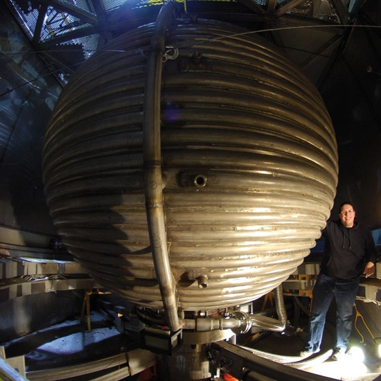
A giant sphere full of 15 tons of liquid sodium, used to simulate the earth's core. Source.

A giant sphere full of 15 tons of liquid sodium, used to simulate the earth’s core. Source.

The spinning liquid outer core produces the magnetic field that twists your compass and tells dogs which direction to pee in. One way to understand the core better is to simulate it in the lab, by creating a giant sphere containing spinning liquid sodium. It’s also a good way for scientists to look a bit more like Bond villains standing next to their super-weapon.

3. You can’t handle the pressure!

It seems counter-intuitive. The earth gets hotter the deeper you go, yet the outer core is molten and the inner solid. Normally things melt when they get hotter, so why is that?

Pressure.

We’re familiar with the fact that pressure increases in the deep sea, as there is a lot of water above, pushing down. It’s the same in the earth, only rock is heavier and there are thousands of kilometres above, pushing down.

The pressures get so intense that the only way to reproduce them in the lab is to take an tiny unfortunate sample of rock, put it between two diamonds and squeeeeze. To reach the required temperatures, you also fire lasers at it, through the diamonds. Occasionally the diamonds can’t handle the pressure and they explode, sometimes popping loudly or emitting a flash of light.
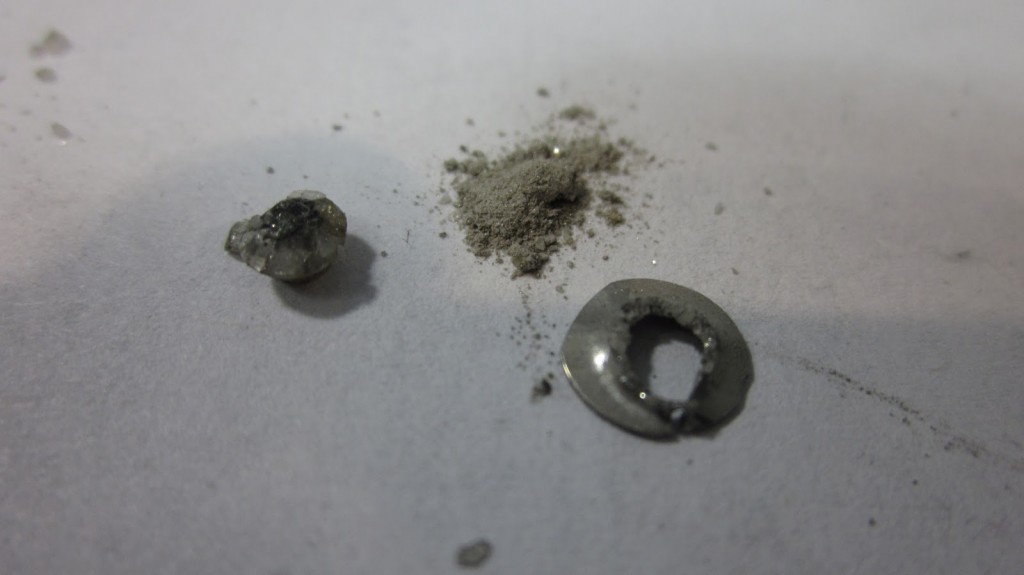
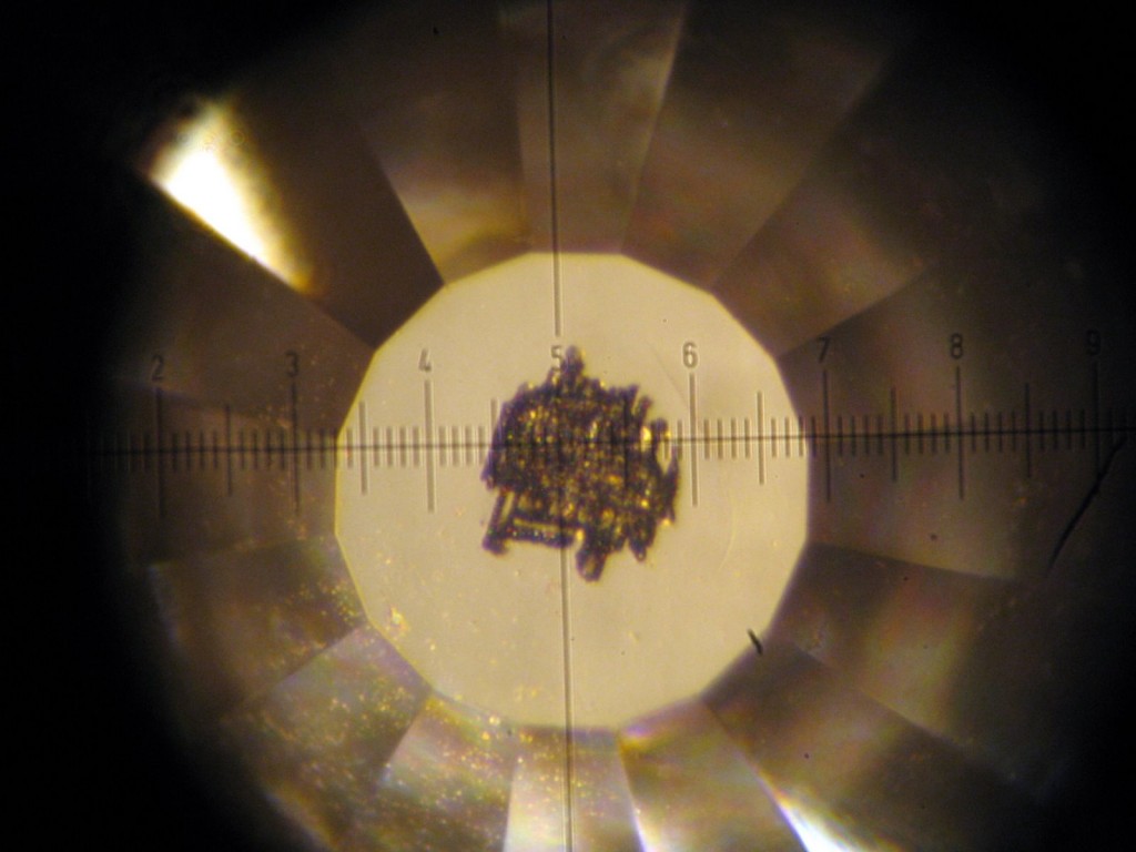
Diamond damaged by laser fire. Image from Wendy Panero.

Diamond damaged by laser fire in a diamond anvil. Image from Wendy Panero.

pile of diamond dust

Pile of diamond dust after ‘blowout’ of the anvil. Source.

Under high pressure, it’s easier for materials to be solid rather than liquid, as the atoms prefer to be tightly packed together. The metal in the earth’s core is solid at the centre because the pressure is higher there.

4. Solid rock that flows

We know from listening to earthquake waves that pass through it that the earth’s mantle is solid. It’s incredibly hot, but the pressure means that – give or take a few percent in places – there is no liquid rock down there.

Knowing this held back acceptance of the idea that continents move. The geological evidence was known, but it was thought that continents couldn’t move because they were attached to the mantle and ‘solid rock can’t flow’. Only it can.

Hit a piece of the mantle with a hammer and it will break (or break your hammer – it’s tough stuff). But heat it up and push it the same way for millions of years and it will flow. It’s made of crystals, endless ranks of atoms lined up in rigid patterns. Tiny gaps in these patterns allow atoms to slip past each other and slightly change the shape of the crystal. Countless of these tiny steps, in myriad of crystals over millions of years allows the earth’s mantle to flow, convecting in majestic patterns driven by heat leaving the earth.

Patterns of plate tectonics on the surface are driven by this flow. The most dramatic example being subduction, where crust sinks down into the mantle, sometimes sinking deep down to the edge of the core.
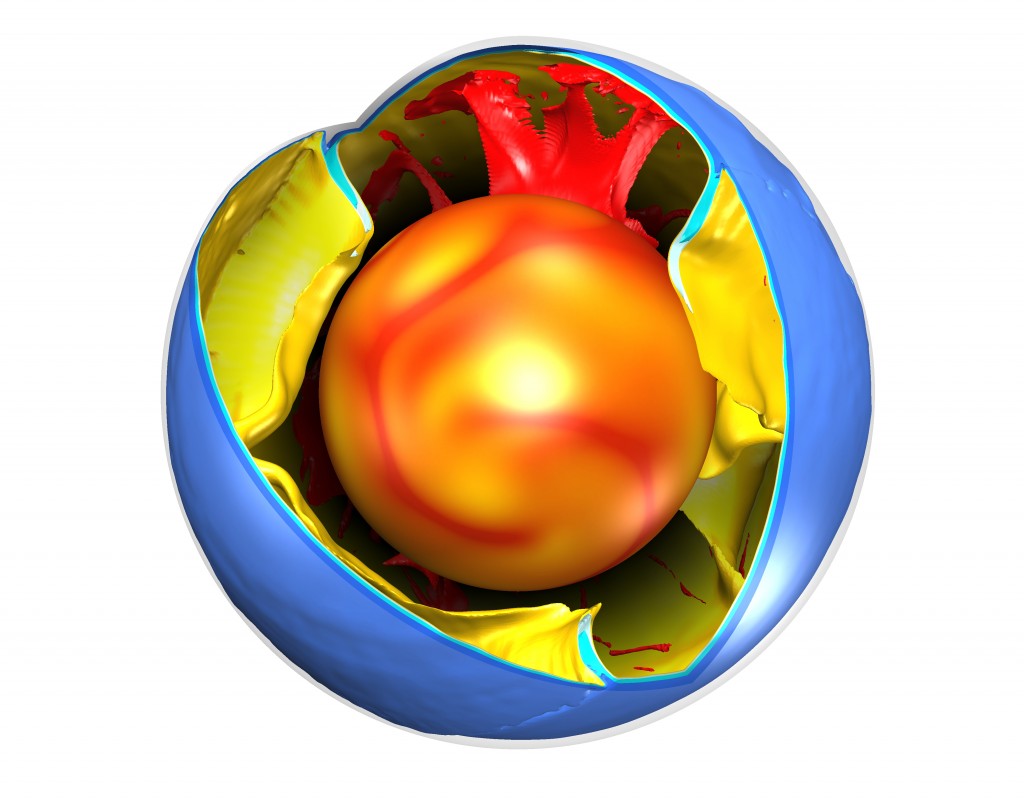
Cut-away diagram showing modern convection from computer modelling by Fabio Crameri. Red is rising plumes, blue sinking plates.

Cut-away diagram showing convection in the earth. Red is rising plumes, blue and yellow sinking plates. Image generated from computer modelling by Mario Crameri.

5. Death from below

The link between meteorite impacts and mass extinctions is well known – the image of a dinosaur looking up at an incoming fireball is almost a cliche. However some scientists think they should be looking down, and that the deep earth has caused more extinctions than impacts have.

The event that did for the dinosaurs, at the end of the Cretaceous (66 million years ago) is just the most glamorous of many mass extinction events. The biggest was at the end of the Permian (252 million years) – up to 96% of marine species became extinct. There is no good evidence for a meteorite impact at the end of the Permian, but there is a huge pile of lava, covering much of Siberia. This was caused by a massive mantle plume, a column of hot rock that started at the base of mantle.

To kill nearly anything you need to foul the sky and poison the seas. Volcanoes give off noxious gases which in normal amounts don’t cause problems. But covering 2 million square kilometres of land in lava is not normal. However it was done – by pumping out massive quantities of ash or by producing carbon dioxide by burning nearby coal deposits  (or some other way) – the link between mantle plumes, lava and death seems pretty certain.

The end-Cretaceous extinction saw a meteorite impact, but it also saw a massive outpouring of lava from the mantle, this time in India, at exactly the same time. There are those who argue that the death of the dinosaurs is as much due to the deep earth as it is a rock from space.

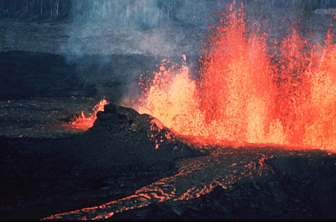
A huge outpouring of lava. From Wikipedia

A huge outpouring of lava. Image from Wikipedia

6. Visitors from the deep

A lot of what we know about the deep earth comes from indirect measurements, like when a doctor uses a stethoscope or MRI scanner to ‘look’ inside your body. But sometimes to know what’s really going on you need a direct sample from deep inside – a biopsy. To do this for the heavenly body we sit on – in other words to perform a geopsy1 – you need a special kind of volcanic rock. When some molten rock rises from the mantle, it contains crystals that were formed at depth, but carried up in it. The most interesting, most glamorous, most beautiful, and most valuable of these exotic visitors are diamonds.

I could go on about diamonds for a long time (in fact, I already have) but forget that they can be made billions of years old, and may contain traces of an ancient oxygen-free atmosphere, instead let’s focus on the fact that some diamonds contain carbon that was once part of a living thing.

When carbon has passed through a process of photosynthesis, its isotopes have a distinctive pattern . Finding this ‘light carbon’ in diamonds allows us to tell an amazing story. Something was once alive2, died and formed black mud on the ocean floor. This was then forced into the mantle where it sank deeper and deeper. At some point the carbon started flowing up (as part of some sort of fluid) and got pulled into a growing diamond which then got caught up in some fizzy magma that, within hours or days, pushed up to near the earth’s surface, where humans could find it and marvel.

Human beings can never reach the deep earth. Alive. The carbon in our bodies might though. Just arrange to die and get buried in the right bit of the sea bed and part of you might one day end up in the deep earth.

References

What to know more? Don’t believe these amazing facts are true? Either way, read these links for more details.

The idea of how to get a probe into the deep Earth come from a pukka scientific paper.

The Death Star isn’t really real (honest), but scientists model the liquid/gas rock that would happen if the earth was destroyed when they model a collision with another planet. Something that may have happened long ago to create the moon.

If you want to see that huge sphere containing liquid sodium in action, see it here.

My information about exploding diamonds came from Mary Panero, who is on Twitter @mineraltoPlanet

All you ever wanted to know about the Siberian Traps and the end-Permian event can be found on a great Leicester University site.

Scientists who believe mantle plumes rather than the meteorite killed the dinosaurs point to evidence from India. The lava (known as the Deccan Traps) is seen to happen at the same time as the extinctions, but the layer of Iridium enrichment comes after the extinction. More details here.

More more information about diamonds, there’s a useful recent review of the science.

A world without subduction

The greatest achievement of the generation of Earth Scientists now retiring is the concept of plate tectonics. The insight that the earth’s surface is made up of rigid plates that move has shed light on all aspects of Earth Science, from palaeontology to geophysics to the study of ancient climates. What’s less well known is that the way the plates interact has changed over time. Key plate tectonic features such as subduction, didn’t happen for large periods of earth history.

Cut-away diagram showing modern convection from computer modelling by Fabio Crameri. White is hot rising plumes, black cold sinking plates.

Cut-away diagram showing modern convection from computer modelling. White is hot rising plumes, black cold sinking plates .  Image used with permission of Fabio Crameri.

Earth scientists have a pretty good idea of the details of how modern plate tectonics works. This has required the integration of indirect observation of modern subduction zones (using geophysical techniques) with direct study of rocks that have been inside subduction zones (such as eclogites) plus the creation of subduction zones ‘in silico’ (with computer modelling).

Of these 3 methods of study, only the first (direct observation) cannot be used on the ancient earth. So what do the rocks and computer models tell us?

Old rocks are odd

We’ve known for a while that ancient rocks (Eoarchean–Mesoarchean, older than 2.5 Ga1are very different from modern ones. Often they consist of greenstone belts – containing an unusual lava called komatiite – surrounded by large areas of granitic gneiss. The pattern of metamorphism in these rocks shows high temperatures, even at shallow depths.

The chemistry of the igneous rocks tells a similar tale. Komatiites only melt at temperatures of around 1600°C – 400 degrees hotter than modern basalt lava. Granitic rocks have tonalite–trondhjemite–granodiorite compositions and are thought to have formed from direct melting of basaltic rock – unlike granites formed above subduction zones today.

Rocks characteristic of modern subduction – blueschists and eclogites  – are not found in rocks this age. There is a pretty good consensus, based on field evidence and model modelling, that subduction did not happen in the early earth. The earth’s mantle was much hotter and more heat was flowing up through the crust. Hot rocks are weak rocks – forcing a slab of rock into the deep mantle requires it to be cold and hard. Hotter rocks act not as rigid slabs but as soft blobs.

Computer modelling confirms the importance of temperature, both of the crust and the underlying mantle. Models are our best hope of understanding what a hot planet without subduction looked like. More like a bubbling pan of porridge perhaps, with tectonics dominated by hot upwelling plumes and lithospheric delamination, with blobs dripping-off down again. Some studies of mantle mixing suggest a ‘stagnant-lid’ model where the earth’s surface layer doesn’t move at all.

Subduction starts

At some point in time between 3.2–2.5 Ga, subduction started. The planet had cooled enough that a lithospheric plate stayed rigid enough to sink down into the mantle. Evidence for this is found in ‘paired metamorphic belts’. Rocks within the subduction zone remain cool at depth (as they are pushed down before they can get as hot as the surrounding rocks) and form eclogites or high-pressure granulite rocks. Rocks nearby in the overriding plate are much hotter and enjoyed granulite–ultrahigh temperature metamorphism.

Mathematical modelling of the earth suggests subduction started because the earth cooled below a particular threshold. As an explanation, this is a little dull. Much more excitingly, coverage of a recent paper suggests massive meteorite impacts about 3.2 Ga could have broken up the surface and somehow kickstarted plate tectonics. Scientists who study impacts are always really keen to use them to explain events or features on earth, whereas other scientists are sceptical, preferring to explain them via things that they study. We’ll need to wait to see who is right about this one (but my money is on the dull explanation).

Cut-away diagram showing modern convection from computer modelling by Fabio Crameri. Red is rising plumes, blue sinking plates.

Cut-away diagram showing modern convection from computer modelling. Red is  hot rising plumes, blue cold sinking plates. Image used with permission of Fabio Crameri.

Subduction as a cure for boredom

When subduction first started, mantle temperatures were still 175–250 °C hotter than today. Hotter, softer slabs are more likely to break off, perhaps making subduction something that stopped and started.

Blueschists and low-temperature eclogites, high-pressure & low-temperature rocks that are found in modern subduction zones are not found until the the Neoproterozoic at 600–800 Ma. Mantle temperatures by then were less than 100 °C greater than today – this marks the wide spread development of modern-style (cold) subduction on Earth. Cold slabs of oceanic lithosphere break-off deep, allowing large volumes of dense oceanic crust to pull continental lithosphere down, creating the first ultra-high pressure metamorphic complexes.

The Neoproterozoic is the end of what is known as the ‘boring billion’ – a time of tedious environmental and evolutionary stability. A recent open acess paper in Geology suggests a link between the exciting changes that followed (glaciations! Cambrian explosion!) and the onset of subduction. The boring billion was stable in part because most continental crust was part of a supercontinent called Rodinia. The paper argues that the disruptive effects of the onset of cold subduction broke Rodinia apart, setting off a chain of events that transformed the world.

—–

The early earth was a very different planet. Understanding it better informs the general subject of planetology. As we get more and more data about other planets (both within and beyond our solar system) it’s natural to speculate on their tectonic activity. Why does Venus not have subduction? Does subduction here exist because of life and its role in moderating climate and creating the earth’s oceans? Ancient rocks and computer models may help us answer these questions as much as probes and telescopes.

REFERENCES

Brown M. (2014). The contribution of metamorphic petrology to understanding lithosphere evolution and geodynamics, Geoscience Frontiers, DOI:
Available here

Cawood P.A. & Hawkesworth C.J. Earth’s middle age, Geology, DOI:
Available here

Gerya T. (2014). Precambrian geodynamics: Concepts and models, Gondwana Research, 25 (2) 442-463. DOI:
Available here

#thinsectionThursday – what Twitter was made for

One of the great privileges of studying geology at university is spending time looking at thin sections. It may not feel like it at the time – learning to identify minerals down the microscope is hard work – but peering into the secrets of the earth is deeply satisfying, both intellectually and aesthetically.

https://twitter.com/chrsphr/status/461928938584166401

For those of us who don’t have access to the kit (thin slices of rock, specialised microscopes) we have to make do with photographs. So I was very pleased to discover that rock-whisperer Chris Jennings (@chrsphr) has invented the Twitter hashtag #thinsectionThursday.

https://twitter.com/chrsphr/status/461911607615184896

Twitter is a great place to share images, and Earth Scientists have long made use of this, posting pictures of long-dead animals (#fossilFriday) and dangerous piles of clinker (#volcanoMonday) on particular days. The potential of #thinsectionThursday is enormous. Thinsection images are often visually stunning – with varied colours and textures – plus the educational potential is vast. They can show crystals that grew in the heart of a volcano, a detailed cross-section of a fossil or the jumbled joyful chaos of a metamorphic rock. Archaeologists, meteorologists and others can play too.

https://twitter.com/TectonoAndy/status/462005832788738048

I’ll be contributing to #thinsectionThursday, please do join me. If you use thin sections day to day, it’s a no-brainer: take pictures from your course-work or research and get tweeting. If you’re not on Twitter, you can still view the images. If you don’t have your own photos, there are other options….

If you use other peoples images on Twitter, you’re benefiting from their hard work, so it is very important to use proper attribution. Lot’s of famous accounts don’t bother, but you are better than them, aren’t you?

One resource I’ve made use of is the British Geological Survey. They have digitised thousands of thin section images as part of their GeoScenic image database *and* within their rock collections (search for S% in the registration number field). They are available for non-commerical use, provided you say it’s their image and provide a link back. It’s always good manners to ask, of course, but I’ve done this on your behalf:

So, what are you waiting for?

Thursday, obviously.

And the opportunity to make #thinsectionThursday the success it deserves to be.

The Himalaya: mountains made from mountains

Good building stones get reused. Sometimes the only traces of very old buildings are their stones, built into more modern ones. It’s the same with rocks and mountain belts. Stone that now forms parts of the Himalaya was once part of a now-vanished mountain range.

The Himalaya were formed by the collision between the Indian and Asian plates. For 50 million years, the Indian plate has been pushed down into the Himalayas where it is squashed, mangled and changed by heat and pressure. Working out the details of this process of mountain building has taken decades of careful study. Modern isotopic techniques are now so powerful that researchers studying Himalayan rocks can peer through beyond the effects of the recent mountain building to see traces of older events.

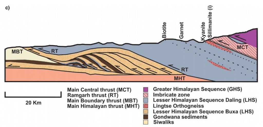
A recent open access paper by Catherine Mottram, Tom Argles and others looks at rocks in the Sikkim Himalaya, around the Main Central Thrust (MCT). As you can guess from the name (and the Use Of Capitals) this is an important structure; it can be traced over 1000km across the Himalaya and separates two distinct packages of rock known as the Lesser and Greater Himalayan Series.

Figure 2c. Cross section of MCT in the Sikkim Himalaya

Figure 2c. Cross section of MCT in the Sikkim Himalaya

As the rocks of the Indian plate were stuffed into the moutain belt, much of the movement of rock was along near-flat faults, known as thrusts. These stack up layers of rock, shortening and thickening the crust. Thrusts near the surface may be a single fault plane, but at greater depths rocks flow rather than snap and a thick thrust zone of deformed rocks is formed. This makes drawing a line on a map and calling it the Main Central Thrust rather difficult. Should the line be placed where the rock types change, or where they are most deformed, or where there is a break in metamorphism? Each approach has its advocates.

Our authors took an isotopic approach, measuring Neodymium isotopes for the whole rock and Uranium-Lead in useful crystals called Zircon. Their analysis shows that the two packages of rock separated by the MCT can be distinguished using isotopes. The actual boundary is not sharp: they prove interlayering of the two rock packages within the thrust zone, rather than a single boundary. This is not surprising given that thrusting is a gradual process and thrust surfaces are not flat.  Deformation seems to have started at the boundary between the Lesser and Greater Himalaya and gradually moved down over time.

The patterns of isotope measurements that can be used to distinguish between the Greater and Lesser Himalayan Series also tell us about what happened before India met Asia.

The zircons whose isotopes were measured are of two types, detrital and igneous. The first are grains that were eroded from old rocks and settled into a sedimentary basin. The second crystallised from molten rock: their ages record significant events. Together these sets of dates give a view of a long and complicated pre-Himalayan history.

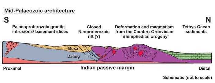
Our authors attempt to reconstruct the leading edge of the Indian plate, as it might have looked before it crashed into Asia.

Figure 10.

Figure 10. “Schematic illustration showing the pre-Himalayan architecture of the Sikkim rocks, during the mid-Palaeozoic. The Lesser Himalayan Sequence lithologies were once separated from the Greater Himalayan Sequence rocks by a Neoproterozoic rift. The Bhimpedian orogeny was responsible for closing the rift and thickened the Greater Himalayan Sequence, causing metamorphism and intrusion of granites. The failed closed rift may represent a weak structure later exploited by the Main Central Thrust. Lithologies are the same as in the legend in Figures 1 and 2.”

The Greater Himalayan Sequence had already been heated and deformed in the roots of a mountain belt long before the Himalayas existed. This a relatively common situation. Polyorogenic rocks such as these1 need to be treated with care, otherwise we might mix up events separated by millions of years. A single garnet crystal may contain different areas that formed in totally separate mountain building events

One of the detrital zircon grains dated in this study was 3,600,000,000 years old. We can only guess how many cycles of erosion and burial, how many splittings and couplings of continents this mineral has ‘seen’. As it was buried and heated once again maybe, like the bowl of petunias in The Hitchhiker’s Guide to the Galaxy it thought to itself: “Oh no, not again”.

References

Mottram C.M., Argles T.W., Harris N.B.W., Parrish R.R., Horstwood M.S.A., Warren C.J. & Gupta S. (2014). Tectonic interleaving along the Main Central Thrust, Sikkim Himalaya, Journal of the Geological Society, 171 (2) 255-268. DOI:

Argles T.W., Prince C.I., Foster G.L. & Vance D. (1999). New garnets for old? Cautionary tales from young mountain belts, Earth and Planetary Science Letters, 172 (3-4) 301-309. DOI: