Eclogites: back to the surface

Eclogites are beautiful rocks that form deep within subduction zones. The vast majority of subducted oceanic crust becomes more dense than the surrounding mantle rocks and travels to the strange world of the deep earth. Lucky for us, small volumes make it back to the surface. How does this happen? As so often in the Earth sciences, a combination of detailed field work, laboratory analysis and modelling yields many insights.
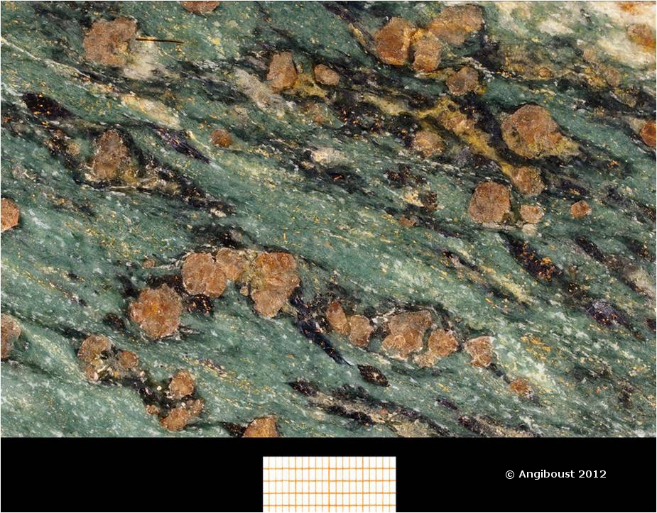
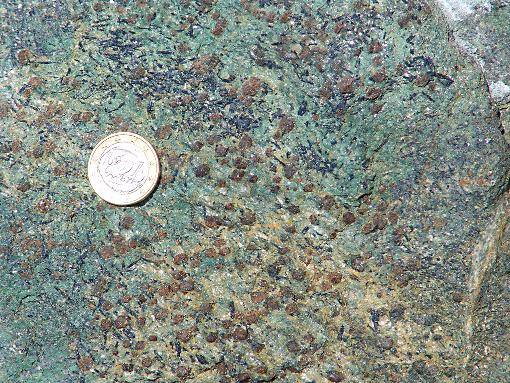
ZS Unit: valtournanche Garnet omphacite + late Gln rims around grt.

ZS Unit: valtournanche Garnet omphacite + late Gln rims around grt. All images in this post courtesy of Samuel Angiboust.

To the Alps

The Alps are a major mountain belt stretching across Europe. They are the result of the closure of the Tethys ocean which used to separate Africa and Europe. The details are complex – oceanic crust remains in the Mediterranean and there are small fragments of continental crust in the mix too. In the western Alps, stretching through Switzerland, Italy and into Corsica, there are large areas of oceanic crust (known as ophiolites). These ophiolites were subducted 50 million years ago and turned into eclogites. They now sit on the surface sandwiched between other less exotic metamorphic rocks, firmly part of the continental crust.

Very recently these rocks have been studied by Samuel Angiboust who (with others) has produced a series of papers. I’ve written about one before, concerning traces of ancient earthquakes. He’s kindly provided me with some photos, so I can give you a view of the rocks before I describe his other research.

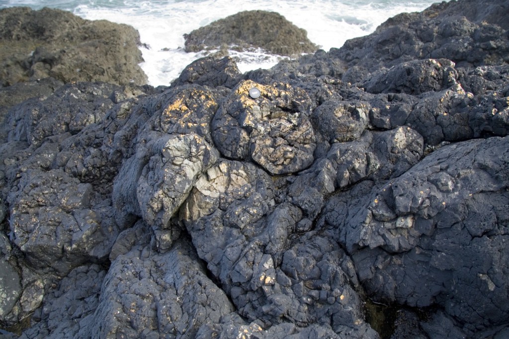
Ophiolites are interesting as they allow us to study oceanic crust without getting our feet wet. These Alpine ophiolites have another added layer of interest – they have also been metamorphosed in complex ways. Here’s an example of what I mean. Ophiolites typically contain parts of the top layer of oceanic crust, ancient lava flows made of basalt that formed pillow shapes as it cooled underwater. Here are some from the Alps.

Eclogite facies pillows, reddish radiolaritic mud between them Monviso Unit (70km depth!)

Eclogite facies pillow basalts.

The structure is unremarkable – pillowed lobes with thin layers of sediment (radiolarian chert) in between.  What is special is that this rock has been buried 70km under the surface. Every mineral grain in it has been recrystallised – nearly every atom in these rocks moved as the rock was utterly transformed under the new high pressure conditions. This movement of atoms is only on the millimetre scale (or less); the edge between sediment and basalt is still sharp. The rock is superficially the same yet utterly transformed.

There is no obvious sign of deformation in this outcrop either, despite them being shoved down into the earth and pulled back out again. Much of the ophiolite is extremely deformed, but little patches of calm often remain even among the most tormented rocks.

Slabs or Knockers?

How do high-pressure rocks get to the surface? One possibility is that eclogite rocks are broken into fragments and somehow squeezed to the surface as tectonic blocks. Some models of subduction zones include a channel of soft serpentinite immediately above the subducting plate. In such a ‘mélange’ rigid pips of eclogite may be squeezed towards the surface. Such things do happen: accretionary wedges, the piles of sediment that form above subduction zones, often contain ‘knockers’* of high-grade rock (including eclogite).

Is this how our Alpine rocks got back up? How could we tell? Angiboust and colleagues look at the record of metamorphism. There are large joined up areas of eclogite, cross-cut by serpentinite shear-zones. If the eclogite came up as pips then each pip would have a different metamorphic history and have reached different depths in the subduction zone.

Metamorphism

In a 2011 paper, available for free Angiboust and others summarise a mass of data from the Monviso Ophiolite, found along the French-Italian border. They found a wide range of metamorphosed rock types, from limy muds (now calc-schists), mudstones (now metapelite) to meta-basalt and meta-gabbro. This allowed them to apply a wide range of techniques to estimate to conditions under which these rocks were metamorphosed.
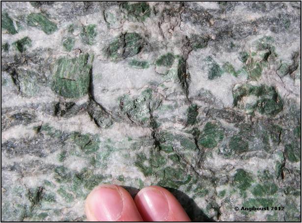
Eclogite facies Mg-Al metagabbro,monviso

Eclogite facies Mg-Al metagabbro, Monviso ophiolite. Green patches are Cr-rich pyroxene (omphacite).

Metamorphic petrology relies on the fact that changing conditions of temperature and pressure transform the minerals present in rocks in predictable ways. Our authors used THERMOCALC, which combines our knowledge of the thermodynamic properties of rock-forming minerals with analysis of the composition of a rock sample and its minerals to estimate to conditions under which those minerals formed. (For more details on what that sentence means, see my posts on metamorphism).
A technique new to me was Raman Spectroscopy of Carbonaceous Matter (RSCM) that analyses the degree to which carbonaceous material (boiled up fossils) has been converted to graphite. The conversion to graphite depends only on the maximum temperature reached – unlike most other ways of estimating peak metamorphic conditions, it can’t be reset and doesn’t depend on pressure. Very neat.
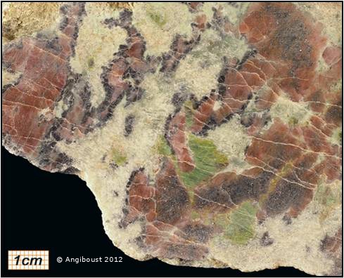
Eclogite facies Mg-Al metatroctolite,monviso Dark chloritoid, green omphacite, pink garnet, white talc (where olivine was. See messiga et al JMG 1999)

Eclogite facies Mg-Al metatroctolite, Monviso Dark chloritoid, green omphacite, pink garnet, white talc (where olivine was. See Messiga et al JMG 1999).

The point of all this painstaking work is to estimate the most extreme conditions reached by these rocks, to discover how deep they reached. By studying over 60 rock samples they were able to distinguish two domains, within which the peak metamorphic conditions were extremely consistent. The deeper Lago Superiore Unit reached conditions of 530–550°C and 26–27.5 kbar, corresponding to burial to 80 km depth. All of this unit reached the same depth, suggesting it hasn’t been broken up since – this is no pip, but a large slab of rock (20–30 km-long, 2–3 km thick) that “corresponds to a more or less preserved portion of thinned oceanic crust detached from 80 km depth in the Alpine subduction zone“.

If this is the case, then how did it get back up to the surface? One reason might be that it was quite wet.

Hydrothermally altered eclogite (Aosta Valley, Italy, Zermatt Saas Unit) With garnet, chloritoid (black), talc (whitish). Enrichment in Fe-Mg (+ pyrite) Due to seafloor hydrothermal alteration led to this very unusual Paragenesis (sample Angiboust, photo Marco Moroni, UPMC)

Hydrothermally altered eclogite (Aosta Valley, Italy, Zermatt Saas Unit) With garnet, chloritoid (black), talc (whitish). Enrichment in Fe-Mg (+ pyrite) Due to seafloor hydrothermal alteration led to this very unusual Paragenesis (sample Angiboust, photo Marco Moroni, UPMC). This rock sample belongs to a fossilized hydrothermal system. Fossilized eclogitized “black smokers” can be occasionally seen on the field in Aosta valley (see Martin et al., 2008)

The role of water

In another recent paper, Angiboust and others discuss the influence of water in eclogites. As newly created oceanic crust cools it can take up a lot of water from the overlying ocean. This is bound up within minerals and so is taken down into the subduction zone. Looking at the Zermatt–Saas ophiolite (Switzerland/Italy) they identify portions of oceanic crust that were extensively affected by hydrothermal processes, perhaps because they formed at a slow-spreading ocean ridge. Now eclogitised, these have between 2.5 and 6% H2O (by weight) which is unusually high. Eclogites more usually have between 0 and 1 %.

All this water affects the minerals that are stable under eclogite facies conditions. Glaucophane is the mineral that puts the blue in blueschist facies – it’s normally stable only under lower pressures. In these ‘wet’ eclogite rocks it remains stable.
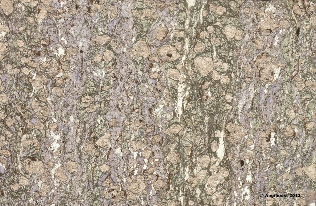
ZS Unit Aosta valley, glaucophane bearing eclogite (scanned thin section 50x30mm) showing that glaucophane may be stable under eclogite facies, together with omphcite + grt _ rutile

ZS Unit Aosta valley, glaucophane bearing eclogite (scanned thin section 50x30mm) showing that glaucophane may be stable under eclogite facies, together with omphcite + grt + rutile.

Lawsonite and phengite are other water-bearing minerals stable in these rocks. All of these water-bearing minerals are significantly less dense than more typical eclogite minerals such as garnet and omphacite. Based on detailed analysis, our authors estimate that these hydrothermally altered rocks are 5-10% less dense than normal eclogite. These are crustal rocks – the mantle rocks beneath were also pumped full of water turning them into serpentinite. Serpentinite is olivine plus water and  about 15% lighter than ‘dry’ mantle rocks.

So overall, hydrated oceanic lithosphere is lower density than both ‘normal’ lithosphere and the surrounding mantle rocks. This keeps it buoyant. This is important as these rocks nearly reached the depth at which normal eclogite becomes denser than the surrounding mantle, at which point subduction becomes irreversible. In these ‘wetter’ rocks low-density hydrated minerals remain stable at higher pressures, so the entire slab is harder to subduct.

Back to the surface

A clue to how these Alpine Ophiolites got back out of the subduction zone comes from the wider geological context. They are now stacked up alongside continental rocks that also reached high pressures. Soon after our ophiolites were subducted the ocean basin closed and continental crust starting being stuffed down into the subduction zone, reaching depths of 80km. This continental subduction became an unstable situation, as continental crust is much less dense than oceanic material. Subduction stopped and the deeply buried rocks were rapidly exhumed, making their way back to the surface.
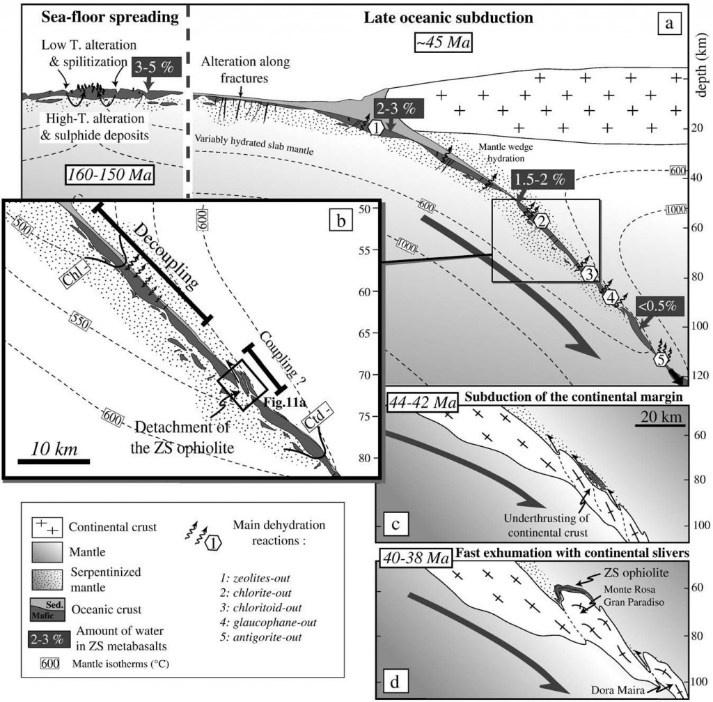
Diagram showing sequence of actions leading to ophiolite slices returning being attached to buoyant continental crust.

Our authors propose a two-stage process. Firstly our ophiolite slices became detached from the sinking oceanic plate. The plate was not smooth and had variable thickness, making this mechanically plausible . They see the detachment being associated with large earthquakes, that would have created tsunami washing across the shores of the Tethyan ocean basin. The next stage is where the thin leading edge of the continental crust is thrust underneath our ophiolite slices. This mixed buoyant material then rapidly returns to the surface, bringing the ophiolite up with it.

This mechanism is a little elaborate, with many particular circumstances being required. However the authors emphasize that the preservation and exhumation of such a big fragment of oceanic lithosphere would have been possible without the mechanical intervention of underlying, buoyant continental crust. That’s why Alpine ophiolitic rocks (and involved volumes) are so unique to understand the steady-state processes potentially occurring at depth in active subduction zones. In his current research, Angiboust is finding evidence for similar large tectonic slices within eclogitic ophiolites in Iran.

The overwhelming majority of subducted oceanic crust is lost forever into the mantle. The story of how eclogites avoid this fate is fascinating and surely not yet fully understood. I’m sure the study of these beautiful rocks will yield more surprises in the future.

*Clearly these weren’t named by an English person, who whom the term ‘knockers’ would have other connotations….

Many thanks to Samuel Angiboust, for the pictures and for providing useful feedback.

References

Angiboust, S., & Agard, P. (2010). Initial water budget: The key to detaching large volumes of eclogitized oceanic crust along the subduction channel? Lithos, 120 (3-4), 453-474 DOI: 10.1016/j.lithos.2010.09.007

Angiboust, S.,, Agard, P.,, Raimbourg, H.,, Yamato, P.,, & Huet, B. (2011). Subduction interface processes recorded by eclogite-facies shear zones (Monviso, W. Alps) Lithos DOI: dx..org/10.1016/j.lithos.2011.09.004

Silvana Martin, Gisella Rebay, Jean-Robert Kienast, & Catherine Mével (2008). AN ECLOGITISED OCEANIC PALAEO-HYDROTHERMAL FIELD FROM THE ST. MARCEL VALLEY (ITALIAN WESTERN ALPS) Ofioliti : doi:10.4454/ofioliti.v33i1.359

MESSIGA, KIENAST, REBAY, RICCARDI, & TRIBUZIO, . (2001). Cr-rich magnesiochloritoid eclogites from the Monviso ophiolites (Western Alps, Italy) Journal of Metamorphic Geology, 17 (3), 287-299 DOI: 10.1046/j.1525-1314.1999.00198.x

Sherlock Holmes and the case of the detrital zircon

The October copy of the journal Geology contains a paper that made me think of Sherlock Holmes. That doesn’t happen very often. One of the fictional detective’s many skills was the ability to get important insights from the sediment found on shoes. The paper “Detrital zircon record and tectonic setting” looks at ancient sediments and proposes a new way of working out how they formed.

Holmes’ methods were based on linking a sediment sample to its source region – recognise sediment as characteristic of a particular area and you know a suspect with some on their shoe has been there. Holmes (and real forensic geologists) rely on the fact that they can visit the place where the sediment came from. Cawood, Hawkesworth and Dhuime on the other hand study ancient sedimentary basins where the source regions are unknown, either eroded away or removed by tectonic rearrangements. How to get insight from these sediments? A real ‘three pipe problem‘ for sure.

Our authors focus on a particular type of mineral grain, common in sedimentary basins: zircon. Zircon ( ZrSiO4) is beloved by geologists as it contain significant amounts of Uranium which is tightly bound inside small crystals. This makes them perfect for radiometric dating – measuring the ratios of isotopes to infer how long the mineral has existed for. If a zircon is in a granite intrusion, the age of the zircon is most likely the age of the intrusion. Measuring the age of zircon in a sediment doesn’t give you the age of the sediment – being eroded and washed into a sedimentary basin doesn’t reset the isotopic clock.  But measure the age of many zircons in a sediment and you start getting insights into the type of rocks that were eroded to form the sediment – the source region.

Sedimentary basins have been classified into different types, based on their tectonic setting. Convergent basins are found near subduction zones and associated volcanic arcs. Collisional basins, otherwise known as foreland basins, form in the space formed where crust is pushed down by the weight of thickened crust. Finally extensional basins form where crust is stretched, either in rift basins or on the edge of oceans. Our authors’ argument is that each type of basin will have a distinctive pattern of ages preserved in their zircons.

Convergent basins, forming near to volcanic arcs are characterised by a large proportion of very recent zircon ages. Nearby eroding rocks may well have been created by recent volcanism. Volcanic ash may even pop zircon grains directly into the sediment. Collisional basins have much fewer grains of recent ages – there are no volcanoes. However their sediment comes from the nearby mountain range made up of relatively recent metamorphic or igneous rocks. Zircons eroded off the high Himalayas that end up in the Ganges basin are 25 million years old. Extensional basins are far from any contemporary or recent source of zircons. Think of sediment forming off the East cost of North America. It will contains zircons formed during a  whole range of orogenies and volcanic episodes, some very old, none very young.

For a couple of decades now scientists have had machines capable of quickly measuring zircon ages so there is a good data set. Our authors scoured this and found evidence to support their thesis. Taking ages of zircons, and subtracting the age of the basin, they plot cumulative ages. Convergent basins do indeed mostly contain very young zircons and collisional relatively young. Extensional basins show a wider variation, and are much more likely to contain older zircons.

Appropriately they try to solve some mysteries. They take data from Precambrian basins where the tectonic setting is a matter of debate and plot it up.

Since life is not a detective novel, the possibility remains that this technique will yield false conclusions. Their identification of the zircon age pattern from the Proterozoic  Moine basin of Scotland as syncollisional puts them in agreement with workers at the British Geological Survey who came to the same conclusion based on a whole range of studies. For this case, at least, the evidence is looking pretty persuasive.

Picture of Zircon crystals from Ryan Somma on Flickr under Creative Commons.
 

Cawood, P., Hawkesworth, C., & Dhuime, B. (2012). Detrital zircon record and tectonic setting Geology, 40 (10), 875-878 DOI: 10.1130/G32945.1

Folded sediments from the Welsh coast

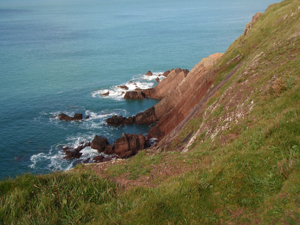
My life is currently in a phase that isn’t compatible with many trips to the field. No complaints, but this does mean a lack of opportunities to take geological photos. So when my mum told returned from a geological field trip to Pembrokeshire in Wales, I was soon pestering for a copy of her pictures. I was not disappointed, as you shall soon see.

Sticking out of the southwestern corner of Wales, Pembrokeshire contains a range of rocks, from Precambrian to Carboniferous. The above photo is of Devonian rocks of the ‘Old Red Sandstone’. These were deposited on the bones of the Caledonian orogeny in a continental setting (hence the red colour).

These sandstones started off as flat layers sitting on top of older folded sediments. Geology being complex, they didn’t stay flat for too long. The Variscan orogeny, which along with the American Alleghenian orogeny helped form the supercontinent of Pangea, caused folding of sediments across South Wales.

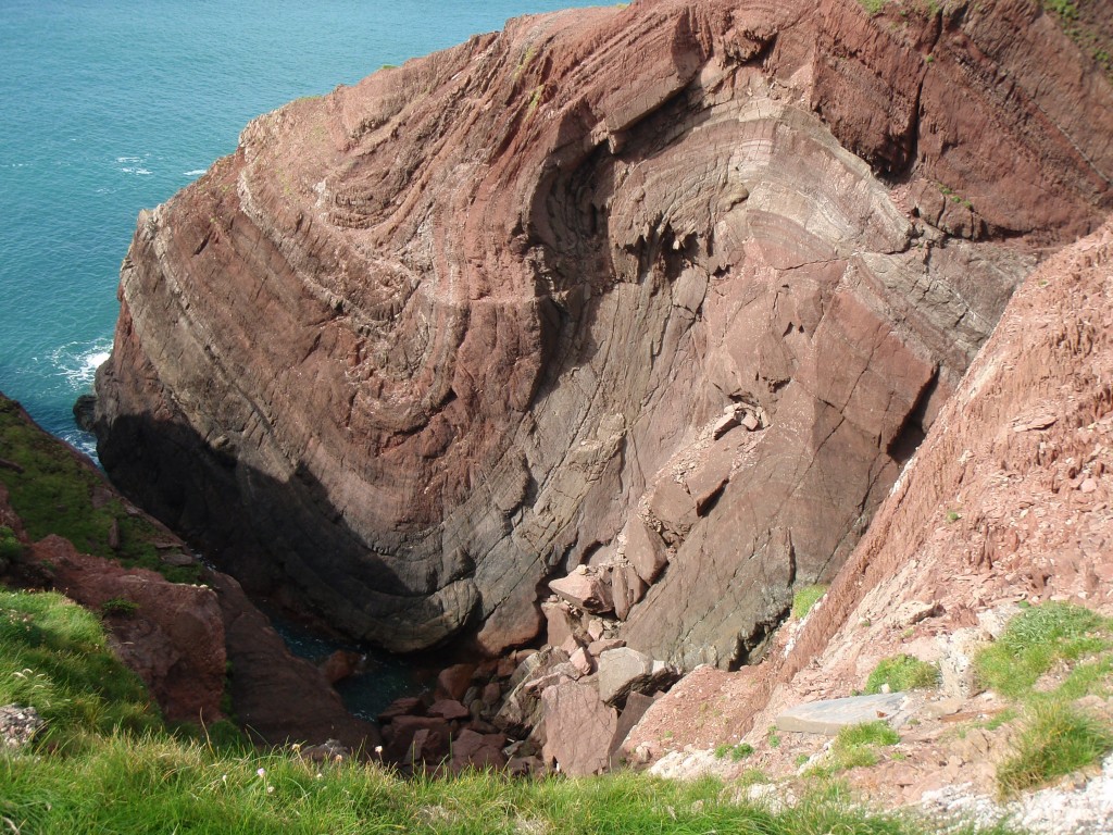
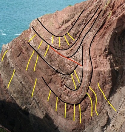
Here’s another example of the folding, from St Ann’s Head (click on it for a big view).

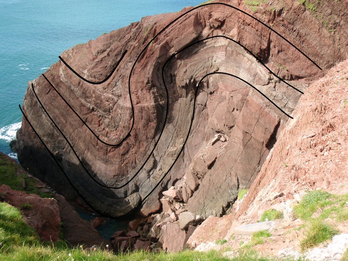
Let’s bring out some of the structure.

Note how the lines are of different shapes. Think about the folding process. These rocks are barely metamorphosed, they are in essences still layers of sandstone. As they are folded they’d much rather not change shape or thickness. Rocks like this often deform by a mechanism called flexural slip, where the layers slide past each other.

From a geometrical point of view, how do these different shaped folds sit alongside each other. Well, they  don’t – at some point the layers need to fracture.

Here’s a more detailed view of the left-hand fold.

In the core of the fold, the layers just don’t match up. I’ve put a red line at the most obvious mismatch – this is likely the location of a minor fault.

In yellow, I’ve highlighted some of the axial-planar cleavage visible in the rocks. Cleavage is where rocks have planes of weakness in them, as a result of deformation. They are a result of alignment or dissolution of minerals as a result of the deformation of the rock. Note how the angle of the cleavage relates to the fold, not the layers. In the core of the old (the axis) they are perpendicular to the bedding and on the limbs of the fold they are at an angle. Some of the lines are curvy, which is cleavage refraction, where the angle varies depending on the physical properties of the rock.

The cleavage, the folding and the minor faulting all formed at the same time – different ways the rock tried to deal with being squashed.

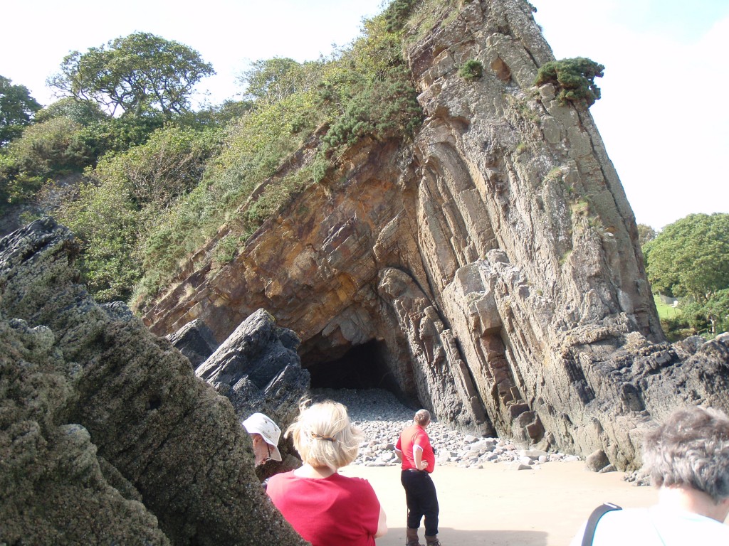
Here’s another Pembrokeshire fold, here in Carboniferous sediments. The style of the fold is completely different – much more angular, with deformation concentrated in the hinge of the fold. The limbs have been rotated, but may otherwise be little deformed.

Oceanic crust – that sinking feeling

Some rocks lead a quiet life. Stable parts of continental crust just sit there for billions of years, doing nothing. In the oceans things are much more dynamic. Live fast, die young, stay pretty is the motto of oceanic crust. It goes on one of the most amazing journeys rock can take. Along the way it affects well nigh everything in and on the planet. Let’s tag along.

Making the crust

Mantle material, usually made of a dark heavy rock called peridotite, is odd stuff. Whenever I’ve seen it on the surface it always looks out of place somehow, too homogeneous, too brown, too massive. Yet it forms over 80% of the earth’s volume – excepting the metallic core it is what earth is made of. Found everywhere immediately below the crust, from between 5 to 75 kilometers depth, it is very very hot (> 1000 °C) – hot enough so that it flows (slowly to us, but fast on geological timescales) but still remains solid. The top, “lithospheric”, layer of mantle has ‘frozen on’ to the crust, becoming part of a rigid plate. The rest makes up the “aesthenosphere”, where the mantle is constantly flowing and mixing, like hot soup in a saucepan.

Our little piece of oceanic crust is about to be formed at a mid-ocean ridge, where two plates move apart. This makes space that is filled by part of the hot mantle rising up – whereupon the reduction in pressure causes it to melt. Rock is made up lots of different minerals and when it melts it usually doesn’t melt completely and produces a magma that has a different composition than the original rock. Shallow melting of mantle material gives basaltic magma. This rises up and pools into magma chambers. Here it may cool to form coarse gabbro, or flow upwards through cracks to form basalt lava flows, or cool in the cracks to form a sheeted dyke complex. This creates a characteristic layered pattern in the crust.

pillow basalts from http://www.flickr.com/photos/19311544@N00/2882765413

Pillow basalts. Image from Earthwatcher on Flickr. http://www.flickr.com/photos/19311544@N00/2882765413

All of this is taking place under water. A 2.5 km thick pile of water in fact. When magma reaches the surface, it flows out as lava but it cools extremely quickly and forms piles of distinctive pillow shapes. Water also flows down into the crust where it is heated up. When it comes back to the surface, at places called hydrothermal vents, it may form dramatic chimneys called black smokers, built up as minerals precipitate out of the suddenly cooled brine. Water is making important changes under the surface, changing the original igneous minerals into new ones, often by putting H2O into the mineral structure.  Incredibly, it seems there may be bacteria living in this hot wet rock deep below the surface.

That sinking feeling

As our new crust slowly drifts at finger-nail speed (5 cm/yr) away from the ridge, it cools and grows denser, causing the sea-bed to sink. Sediment builds up on top. We are a long way from land and the sediment tends to consist of dead things with great names falling from above – diatomaceous ooze, globigerina ooze, the Titanic. It depends.

After 50Ma (million years) our crust is denser than the underlying mantle. It would sink down into it, but it is part of a rigid plate so it can’t – until it reaches a subduction zone, that is. Subduction zones, usually associated with deep ocean trenches, are found around the world. They are doorways – a place where our crust leaves the surface and enters the interior of our planet.

As it moves down into the subduction zone, our crust is pushed down under another plate. It bends down and starts to sink into the mantle – the older the crust, the steeper the angle. Some of the sedimentary cover is scraped off, to form an accretionary wedge above the plate. All this scraping and bending is associated with earthquakes, some of the strongest ones known. The bending of the plate allows water to get into the mantle part of the plate, further changing its composition.

Subduction zones and mid-ocean ridges are linked. In them, creation and destruction is broadly balanced. Oceanic crust is created from the mantle and returns there to be destroyed. The balance is not perfect: 0ceanic crust starts of different in composition from the mantle and all that brine it interacted with caused many chemical changes. The crust returns changed and can’t just turn back into peridotite – it stays as something more interesting.

As our crust starts to sink deeper into the subduction zone, the pressure increases. A lot. Imagine the pressure of a kilometre of rock sitting on top of you (I bet you can’t). For every kilometre the crust descends, the more rock is pressing down on it. The temperature increases too, but to a lesser extent – the cold crust takes a long time to heat up.

As conditions change, two things start to happen, metamorphism and metasomatism. Firstly the minerals forming the basaltic rock (such as plagioclase, pyroxene, olivine) become unstable and new minerals are formed –metamorphism. This process is fairly continuous as the conditions change, but the most dramatic (and attractive) transformation occurs about 2 million years after subduction starts, at around 50 kilometers depth. Here the basaltic rock turns into eclogite.

eclogite with rutile from http://www.flickr.com/photos/30659367@N00/60820842

Eclogite with rutile. Photo from Graeme Churchard. http://www.flickr.com/photos/30659367@N00/60820842

Many of the metamorphic reactions affecting the crust release water which flows from the subducting crust up into the wedge of mantle sitting above it. Water is a fantastic solvent, so it takes other elements up dissolved with it – this flow of material is called metasomatism. These elements tend to be ones that make large ions, like Potassium and Boron- they are harder to fit into the increasingly tightly-packed mineral structures that form at depth. It’s as if they are being squeezed out of the rock.

How on earth does a slab of rock force its way deep into the earth? The driving force is density. Old cold subducting crust starts off denser than the surrounding rock and the process of turning it into eclogite makes it 10% denser still. Over geological timescales the mantle behaves like a stiff fluid and a cold and rigid dense plate is able to force its way into it. The force generated by the sinking plate is called slab pull and is one of the major drivers of plate tectonics. Eclogites make the world’s plates go round.

After burial, rebirth

A lot of what we know about subducting crust comes from pieces of it that have somehow got back to the surface. We don’t know of any eclogite that has been deeper that 150km, so as our plate sinks further down we have to infer what is going on using indirect methods.

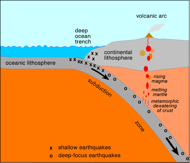
One such method is to study the pattern of earthquakes associated with modern subduction zones. Over time, plotting their distribution picks out the subducting plate and shows that typically it carries moving down to at least 650km depth.

One, rather important, consequence of subduction is the creation of volcanic arcs. These are chains of volcanoes, parallel with the subduction zone, typically about 100km along the surface from the trench. Many major modern day volcanoes, such as Mount St. Helens and Krakatoa are found in volcanic arcs.

subduction diagram from http://www.flickr.com/photos/44615724@N05/6128547564

Subduction zone – diagram from infringer1 on Flickr (http://www.flickr.com/photos/44615724@N05/6128547564)

Working out what is going on below volcanic arcs relies on the indirect tools provided by geochemistry – studying the composition of earth materials. We know the composition of what we start with (subducting crust and mantle materials) and of what we end up with (volcanic rocks) and comparing the two gives insights into the process.  It’s complex.

At depths of 100-250 km the oceanic crust begins to melt. The resulting magma, along with the water mentioned earlier, rises up into the wedge of mantle above. This rising material then lowers the melting point of the hot mantle wedge, so in turn parts of that melt. This new mantle-wedge melt is what rises to the surface and forms the volcanic arc. On the way it may be further modified by melting and then mixing with the crust it is intruded into. The end result is that mantle melting ends up  producing rock with a very different composition, called andesite.

This process is worth studying in detail as it is one of the main engines of continental crust formation, producing the stuff that most of you are currently sitting on. Over time, volcanic arcs have been the major mechanism for turning mantle rocks into continental crust. [If you are not sitting on continent, how’s the pineapple/cod cheeks tasting tonight?  I’ll get to the creation of your oceanic island in the next post]

Subduction is involved in not one but two interlocking cycles of creation and destruction. Oceanic crust is created, but it is destined soon to return to the mantle at subduction zones, to make space for newer crust.  Squeezing out of the water the crust gained from the oceans helps create new continental crust. Eclogite plays an important role in both cycles – it helps pull the mid-ocean ridges apart by slab pull and it sweats out the fluids that kick-off the creation of volcanic arcs.

I talk of destruction, but our crust still lives on, transformed. Maybe 40% of it has melted and flowed upwards, but it it is still a distinct slab, different from the surrounding mantle. By now it  has travelled 250km down, after about 10 million years of subduction. It’s journey is far from over with 10 times as far to sink still. We’ll continue the incredible journey in another post.

Further reading

I found the paper Metamorphic chemical geodynamics of subduction zones an invaluable recent summary of the details of metamorphism within subduction zones and how it drives melting. The link is to a freely available copy.

Dana Hunter’s recent post over at Rosetta Stones gives a perspective on what its like to live above a subduction zone. She’s also writing extensively about Mount St. Helens and the drama caused (indirectly) by devolatilisation reactions in eclogites.