Getting a nose for folds

Folds are found everywhere layers are. Folds are the natural consequence of pushing a rug, cooking lasagna or deforming sedimentary or metamorphic rocks. Sniffing out folds, ‘getting a nose for them’, is part of any geologist’s training.

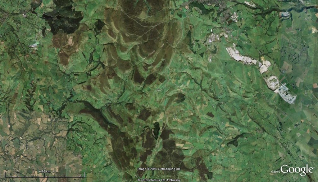
Here’s a Google Earth image of a chunk of northern England.

WoGE-223

What may catch your eye is the pattern of ridges (highlighted by alternating brown peak and green grass) in the central third of the image. There is a “V” pattern that is particularly clear in the southern part. These are sedimentary layers that were originally flat. The image is about 20km across, so on this scale it is basically flat. This means that the pattern can only be explained by folding of those sedimentary layers.

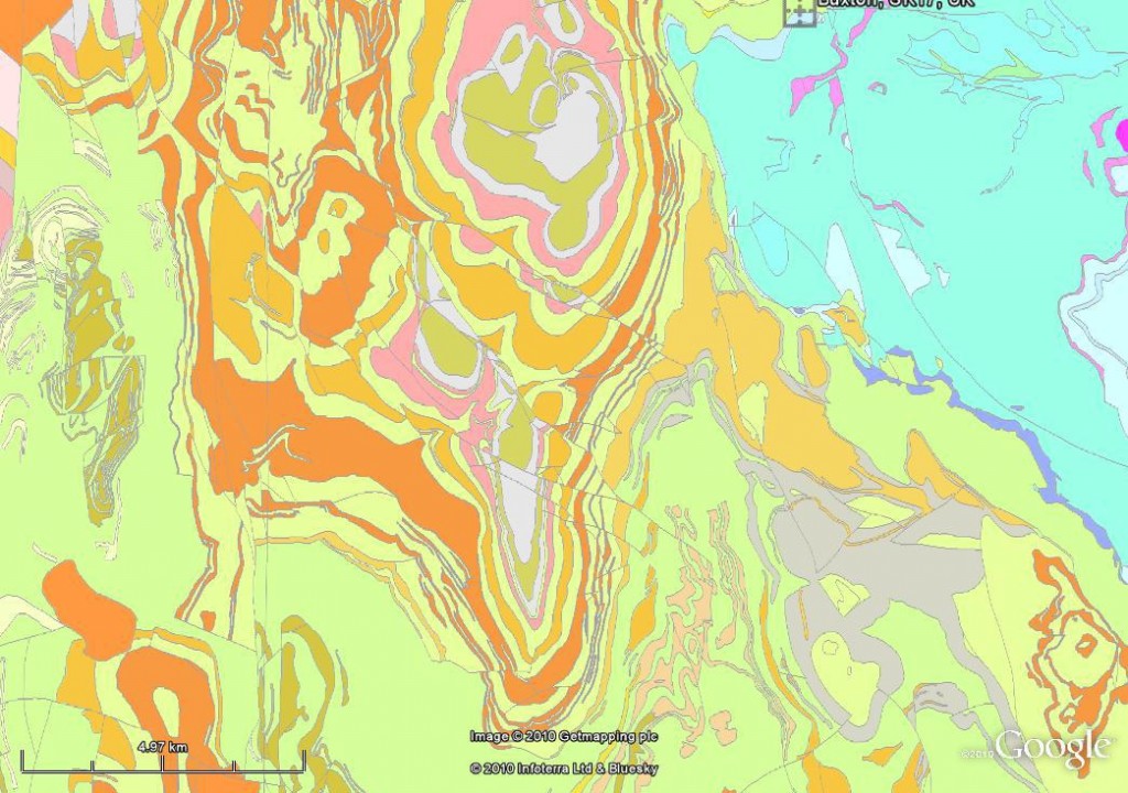
The geological map shows more clearly that the ridges correspond to individual layers of rock (a single colour on the geological map) that are repeated on either side of the “V”.

WoGE-223_geol_map

This structure is called the Goyt Syncline. Away from our astronauts eye view, how does it look on the ground?

20131229_142016

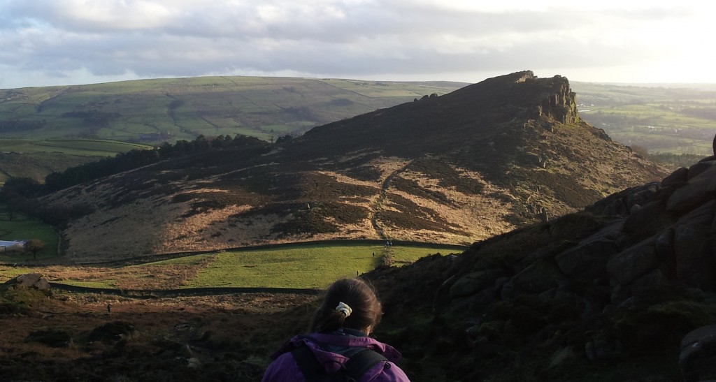
Standing here on one of the ridges (called the Roaches), it is clear the rocks aren’t flat. I hope you can see the flat surfaces sloping down to the left. These are tilted bedding planes.

Here’s a view of the whole fold. The ridge on the skyline is the one the above photo is taken from. It it dipping towards us. The ridge in the foreground is dipping away from us – we can see both sides of the fold. The “V” is lying on the ground, the tip is towards the left.post-Macc holiday 2012 035

And with a bit of annotation:

big syncline image annotated

The nearer ridge, called Ramshaw Rocks is very straight and must have inspired the Romans as they built one of their linear roads just below it.

Finally, here’s a view taken off the left hand side of this picture looking straight at the tip of the “V”.

20131229_155635

The bowl like shape of the syncline fold is clearest here. The two limbs of the fold (the arms of the “V”) are very close here as we are near its tip. This is known as the nose of the fold.

Granites and their space problem

Look at a large-scale geological map and, provided the area is not covered in recent sediments, there will be large areas of red showing outcrops of granite. There are many ways in which rocks can be melted to produce granitic magma. But it’s long been recognised that there is a ‘space problem‘: how do those big red areas on a map form? How does the molten rock get there and where has all the rock that used to be there gone?
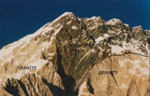
Nuptse south face geology annotated

How did all that granite fit into there?

The easy stuff

Let’s start with the easy explanations. First, intruding magma near the surface. There are a range of structures – sills, dykes1, laccoliths, and ring dykes – that are associated with intrusion of magma at shallow depths. All of these features involve magma moving along a plane of weakness (a fault or bedding in sedimentary rocks) and forming a relatively thin layer. Making the space is no problem – the magma can simply push the surface up. Satellite imaging of volcanoes often shows the surface rising up and down as magma moves about so no problem here.

Large areas of granite are more common at greater depth. If there is 10km of rock above, it is not obvious how the magma could push the surface up. Also a typical granite intrusion forms an oval shape on the surface – how does such a shape form?

Inadequate solutions

Papers on plate tectonics sometimes sketch out things in a cartoony way. For island arcs, where they want to show the extensive granite intrusions, people often draw as a blob, with a little tail at the bottom. It’s only a cartoon, but it conveys a popular but incorrect idea – that granite magma ascends as a diapir. 

In sedimentary basins it’s not uncommon for thick layers of salt to become unstable and for some to rise towards the surface as a blob-like diapir, like wax in lava lamp. For a long time it seemed plausible that light granite magma moved up through the crust in the same way. It would certainly explain the round shape of intrusions. However granite can only flow when it is hot. Unless it is in the lower crust (or perhaps in hotter Archaean crust), doing the maths shows that any granite diapir would cool and freeze long before it got anywhere.

Just say no to granite diapirs

Just say no to granite diapirs

Another concept that doesn’t quite explain how granite intrusions form is stoping. This is the process where blocks of the surrounding ‘country rock’ fall into the granite and are sometimes melted. Granites are often rich in such fragments (called xenoliths), but it is only a marginal effect. The vast majority of a granite intrusion is granite brought in from elsewhere – stoping doesn’t help explain how space is made for it.
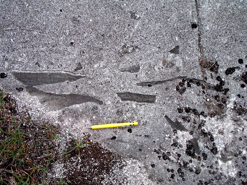
Granite from Donegal. Xenoliths in microgranite near Polcrovehy. Courtesy of Carl Stevenson.

Granite from Donegal. Xenoliths in microgranite near Polcrovehy. Courtesy of Carl Stevenson.

Modern ideas

Melting of rocks to form granite magma is more common in the lower crust (it’s hotter down there). This is a continuous process and it turns out that it is fairly easy to squeeze out the magma, even if it only forms a small percentage of the melting rock. Rock-melt mixtures are very soft and easily deformed. When this happens, the magma is easily squeezed out and being light and under pressure, it moves its way upwards.

Part of the reason for the popularity of the diapir model was the thought that granite magma was too sticky to flow up dykes the way basaltic magma does. Basaltic magma on the surface (where we call it lava) flows beautifully, whereas lava of granitic composition flows only reluctantly – instead it tends to get stuck in the volcano which eventually explodes2.

More modern studies of the viscosity of granite magma show that within the middle crust, granite magma can easily flow up vertical cracks. It can do this extremely quickly and it can happen with small volumes of magma.

It turns out therefore, that all these great big red areas on geological maps are actually made up of many small batches of magma joined together, either as separate sheets or by mixing within a magma chamber. This makes sense – it more closely matches the record of surface vulcanism – volcanoes don’t grow overnight but through a series of many eruptions.
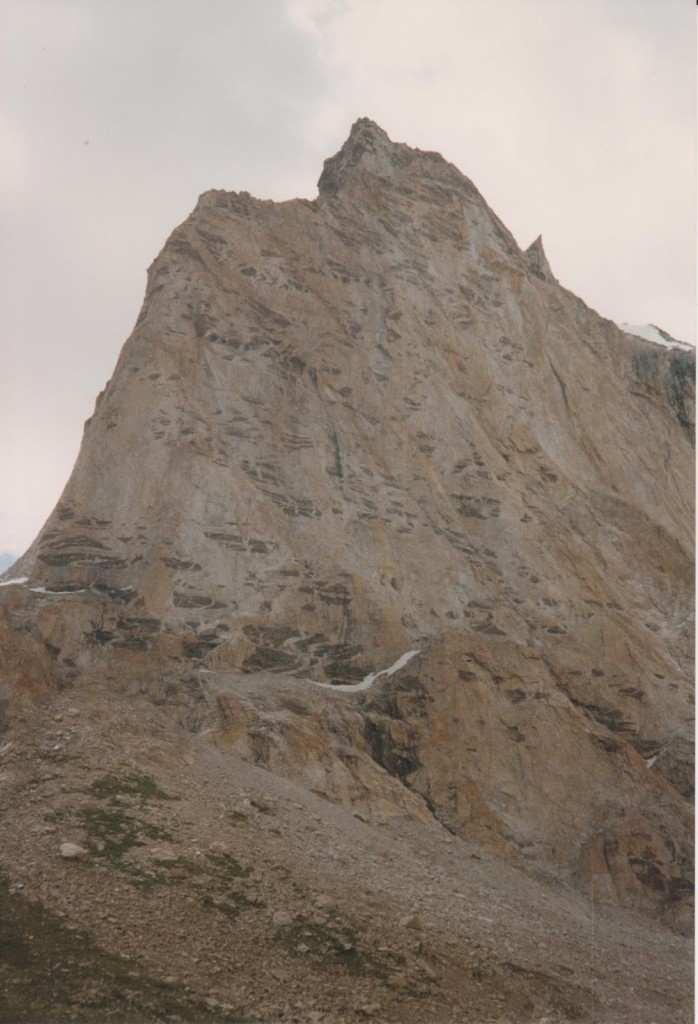
Gumbaranjon, Ladakh, India

Complex granite intrusion, with dark xenoliths. Gumbaranjon, Ladakh, India.

How do large intrusions form through multiple batches of magma? Just like shallow intrusions, they tend to make use of existing structures. Only in the middle crust these aren’t brittle structures and sometimes they are still moving as the granite arrives.

A good way of illustrating all this is to go to Ireland.

Irish men of granite

Before we get to the rocks – an interlude. For me the best granites are Irish for personal reasons. Much of the best research into granite emplacement has involved graduates of Queens University, Belfast. Donny Hutton, John Reavy, Ken McCaffrey and Carl Stevenson were all trained there and have worked on Irish granites. John Reavy taught me and I’ve encountered all the others in some way or other: for me granite is best pronounced with an Ulster accent.

To drift off on a tangent a little, a story John Reavy told me about being a trainee geologist in Northern Ireland during ‘the Troubles’. Belfast city centre was regularly bombed by terrorists during this time. Fancy buildings would be seriously damaged, their polished stone cladding (including granite) broken into pieces and flung about the shattered streets. Enterprising geologists would then pick up some nice samples, once the dust had settled. Life goes on, after all.

To Donegal

Back to the rocks.

Map of Donegal's granites. Taken from Stevenson et al. (2007)

Map of Donegal’s granites. Taken from Stevenson et al. (2007)

The granites of Donegal are classics. In the 1980s, a series of papers by Donny Hutton laid out the link between the granites and deformation of the surrounding rocks. A key finding was to show that the granite magma was intruded at the same time the surrounding rocks were being deformed. This was a neat trick, partly because at the time there was no way of dating deformation directly. Dating intrusions however, was possible.

Sometimes the Donegal granites were deformed after they became solid rock. We can tell this because all mineral grains are affected and some have flattened shapes.
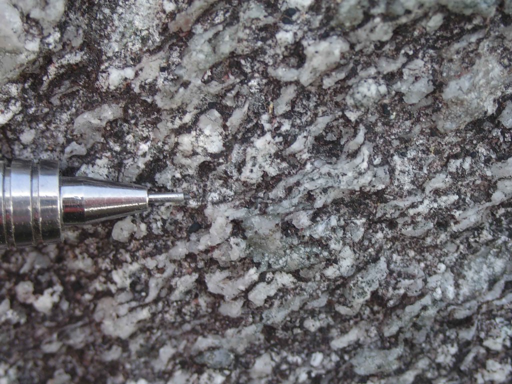
Dextral shear – strong solid state fabric from the quartz in Donegal granite. Photo courtesy of Carl Stevenson

Strong ‘solid state’ fabric in Donegal granite, note the flattened quartz grains indiciating deformation of solid granite. Photo courtesy of Carl Stevenson

Some of the granite was deformed while partly liquid. In this case all the mineral grains look perfectly normal, only some structures are aligned. Minerals that form early in the crystallisation process may be aligned but are themselves undeformed – they were rotated as a crystal-melt mush was squashed.

Using such techniques, Donny Hutton showed that the Donegal granite formed within an active shear-zone. This led to a period of 10 years where pretty much every granite pluton in the British Isles had its intrusion linked to active structures. If rocks are deforming there are lots of ways in which space can be made for granite intrusions to form.

State of the art

When I was doing my undergraduate mapping in Donegal, the easiest bits to map were the granites. Granite was granite, as far as I was concerned – easily identified and quickly marked on the map. This was fine for that level, but with enough work, it’s possible to distinguish between individual batches of magma by clocking subtle differences in mineralogy or grain size. There’s a beautiful example of this from El Capitan in Yosemite.

Another technique tells you more about the structures within the granite. Some granites are rich in structures – aligned minerals or composition variation, you can find examples in many places. However granites that look featureless may contain minerals that are aligned. A technique called “anisotropy of magnetic susceptibility” or AMS allows us to measure the orientation of magnetic grains within the granite.  This can pick up fabrics even in weakly deformed granite (or other materials).

Applying these techniques to the Donegal granites allows a detailed picture to be built up.

The Main Donegal Granite (MDG) marks the site of a major crustal shear zone that provided a route of ascent for multiple batches of granite magma. It now is filled by sheets of granite, often deformed, that entered space created by dilation of the shear zone. Some batches of granite that ascended this way ‘leaked out’ of the shear zone.

One of the leaked batches ‘ballooned’ out, pushing the surrounding rocks out to form the circular Ardara intrusion. Other leaking batches intruded less forcefully, forming horizontal sheets (called laccoliths) that thicken out in domes to various degrees.
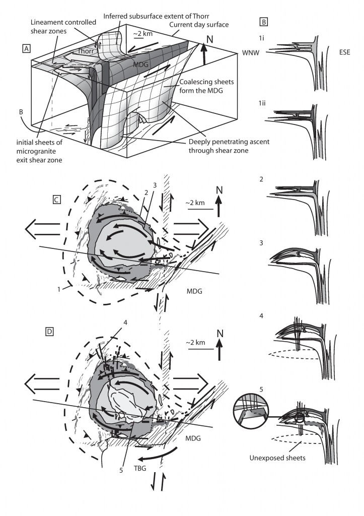
Diagram showing interaction between ascent and emplacement of Donegal granites. From Carl Stevenson

Diagram showing interaction between ascent and emplacement of Donegal granites. From Carl Stevenson

The space problem solved

The Donegal granites demonstrate two processes that are of global significance: how granites ascend and how they are emplaced. Vertical structures allow granite magma to flow up in small batches. At a particular level in the crust they migrate sideways and are emplaced, often as horizontal sheets.

By using existing structures and building up intrusions via small batches, there is no need to massively deform the surrounding rocks, the way diapirs would have to. Looking at a map view of granites, a sea of red, it is hard to think where the rock that used to be there has gone. As often in geology, the answer is to think in 3 dimensions – the rock was either pushed up (and has since been eroded) or was pushed down under the granite. Thinking about the crust as a whole, moving granite magma from the lower crust into higher rocks doesn’t involve a significant change of volume. Material melted out of the depths creates a sheet in the middle crust, pushing down the intervening rocks.

A theme of granite intrusion studies from Ireland and Scotland is the importance of pre-existing structures, particularly active ones. In detail, two sets of structures are important – the main MDG shear zone and a nearly-N-S lineament, that is believed to be linked to a major crustal structure.

Work on the equivalent rocks in Scotland (by Jacques and Reavy) presents a regional model where the lower crust is made up of a series of ‘lozenges’ formed by the intersection of two sets of structures (one set related to contemporary plate tectonic movements, the other pre-existing). Granite intrusions are predominantly found where these structures intersect. Movements along them may have influenced the siting of melting, the ascent of the granite and also their emplacement.

The problem of how granite intrusions form has long been known of. The tale of how it was solved is a typically geological one, requiring the synthesis of many techniques and the application of ‘four-dimensional thinking’. A problem best seen in a geological map can be solved by thinking how rocks move vertically and change over time.

References

Stevenson C.T.E., Hutton D.H.W. & Price A.R. (2006). The Trawenagh Bay Granite and a new model for the emplacement of the Donegal Batholith, Transactions of the Royal Society of Edinburgh: Earth Sciences, 97 (04) 455-477. DOI:

Petford N., Cruden A.R., McCaffrey K.J. & Vigneresse J.L. Granite magma formation, transport and emplacement in the Earth’s crust., Nature, PMID:

Stevenson C. (2009). The relationship between forceful and passive emplacement: The interplay between tectonic strain and magma supply in the Rosses Granitic Complex, NW Ireland, Journal of Structural Geology, 31 (3) 270-287. DOI:

JACQUES J.M. & REAVY R.J. (1994). Caledonian plutonism and major lineaments in the SW Scottish Highlands, Journal of the Geological Society, 151 (6) 955-969. DOI:

Ireland: good terrain for terrane training

The word terrane has a very specific geological meaning. Usually short for tectonostratigraphic terrane, they’ve been defined as “fault-bounded crustal blocks that preserved a geological record distinct from that of adjacent terranes” (Jones
et al., 1983).

The concept was first coined as a way of understanding the rocks of the North America Cordillera. We know now this area is a collage of different terranes that were added (“accreted”) to the proto-North American plate (Laurentia). Some formed part of the core continental plate. Others formed within the vanished ocean, as pieces of volcanic arc, accretionary wedge or oceanic crust. Others are pieces of continental crust that came from further afield, such as Arctic Norway.

Getting around British Columbia or Alaska is hard and dangerous (think helicopters and grizzly bears). Doing geology in the West of Ireland is much easier (think mini-buses and pubs). This explains its popularity for university field trips. During the Ordovician, various pieces of oceanic and arc crust were scraped onto the Laurentian continent in what is now Ireland. This makes it good terrain for terrane training1.

Getting a handle on a complex jumble of terranes requires geologists to draw on a whole range of geological data. There are some specific concepts that relate to terrane analysis, all nicely illustrated in the west of Ireland.

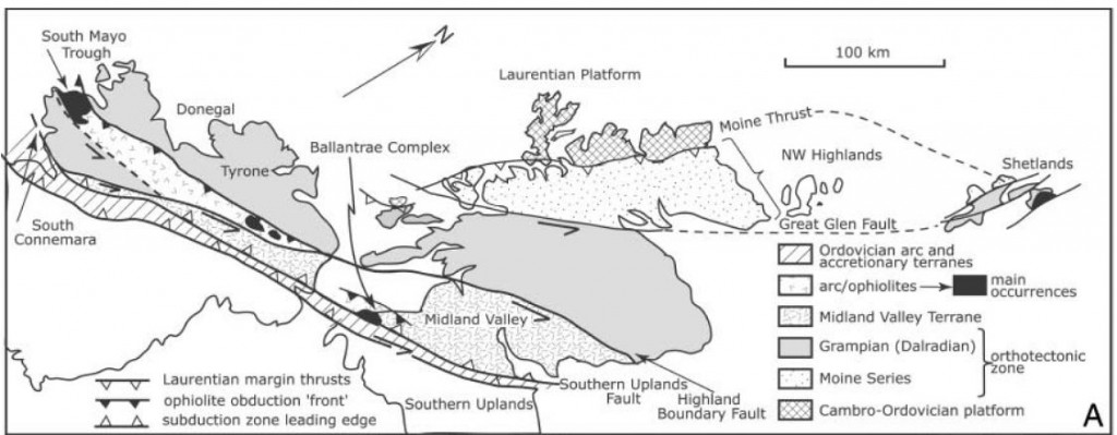
Terrane map of the British Isles. Figure 1a from Dewey 2005

Terrane map of the British Isles. Figure 1a from Dewey 2005

Fossil evidence

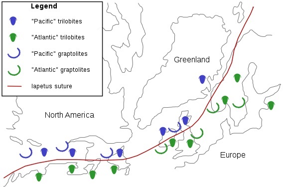
Fossils can be used to get a handle on whether particular terranes were near each other or not. A classic example of this comes from the British Isles. In the 1940s, Stuart McKerrow was a young man on the Atlantic convoys, constantly menaced by Nazi submarines while ferrying American materiel to a hungry Britain . While not winning medals for bravery2, he found time to ponder a mystery. Cambrian rocks in Newfoundland, one end of his dangerous journey, contained trilobites that closely matched fossils from his native Scotland. Oddly trilobites of the same age from England and Wales were very different. Surely it would have made more sense if the fossils from opposite sides of the Atlantic were different, in the same way modern animals are different across oceans.

dx

Diagram showing Iapetus suture as picked out by fossils. Image from Wikipedia

Of course now we understand that the Atlantic did not exist in the Cambrian. During his later career as a geologist at Oxford University, Stuart McKerrow joined others in showing that the line of a vanished ocean, Iapetus, can be traced across the British Isles. Wales and Scotland started off on opposite sides of this ocean. At certain times, species that live in the deep sea were the same, but shallow water (benthic) animals were different – something that requires an intervening body of deep water. His work involved detailed studies of fossils on both sides of the Atlantic, picking out the pattern of plates and terranes, showing how they moved during the closure of the Iapetus ocean.

Stitching pluton

A stitching pluton is an igneous intrusion that joins two or more terranes together. Simple field relationships will show that the intrusion cuts into the rocks of the terranes. The intrusion is therefore younger than them, plus the terranes were adjacent when the magma was intruded. Dating the age of intrusions is relatively simple which means stitching plutons are a simple way to constrain when two terranes were joined.

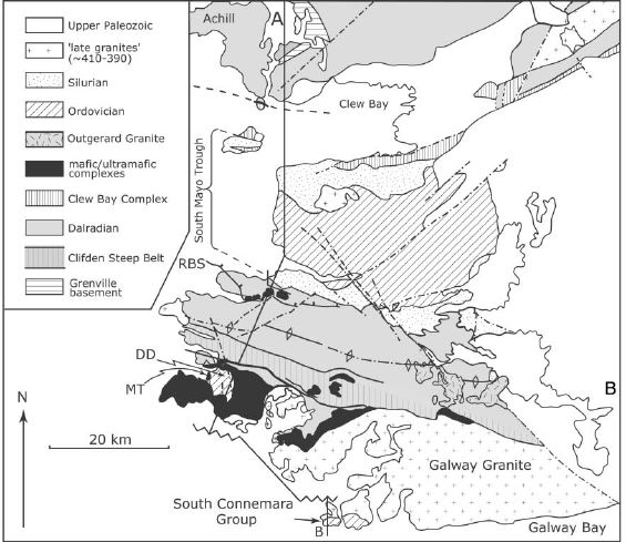
Diagram of Connemara and surround regions. Figure 1b from Dewey 2005

Diagram of Connemara and surround regions. Figure 1b from Dewey 2005

The Galway Granite is a large batholith found on Connemara’s south coast. To its north are the metamorphic rocks of the Dalradian Supergroup. Formed on the Laurentia continent, these rocks were deformed by the Caledonian/Taconic orogeny around 475-460Ma. To the South of the Galway Granite, the South Connemara group is a tectonic melange including abyssal cherts and mafic volcanics with chemistry suggesting they formed at a mid-ocean ridge. These rocks formed at a Ordovician subduction trench.

These two terranes formed in very different tectonic environments, but by 420 million years ago they were next to each other, ready to be permanently stitched together by the Galway granite.

Sedimentary linkages and overlap assemblages

Another way of showing two terranes have become close to each other is to show that pieces of one were eroded into a sedimentary basin on the other. For example conglomerates in the trench rocks of the South Connemara group contain distinctive rock-types common in the Connemara Dalradian terrane to the north. This would suggest the two terranes were nearby while the South Connemara group was forming – that the subduction trench lay along a line now obscured by the Galway Granite.

In a similar way, detailed studies of heavy minerals in the South Mayo Trough  and samples of distinctive igneous rock types can be used to date when the Connemara terrane moved close by. Connemara is the only piece of Dalradian found to the south of the Iapetan arc terranes. For this reason it is thought to have been shifted into its current position by strike slip faulting during the Ordovician.

There is a sedimentary linkage between Connemara and the South Mayo rocks – a set of Silurian rocks that lie unconformably on both terranes. This puts a upper limit on the timing of relative movement. Unfortunately it also obscures the actual contact. The details of how Connemara arrived in its current location remain a mystery.
The concept of terranes is extremely important. Terranes form a vital bridge between the bewildering detail that a field geologist has to deal with and the simple concepts of plate tectonics.

References

Jones, D.L., Howell, D.G., Coney, P.J., and Monger, J.W.H., 1983, Recognition, character and analysis of tectono-stratigraphic terranes in western North America, in Hashimoto, M., and Uyeda, S., eds., Accretion Tectonics in the Circum-Pacific
Region: Terra, Tokyo, p. 21–35.

Dewey J.F. (2005). Inaugural Article: Orogeny can be very short, Proceedings of the National Academy of Sciences, 102 (43) 15286-15293. DOI:

Brown D., Ryan P.D., Ryan P.D. & Dewey J.F. (2011). Arc-continent collision in the Ordovician of western Ireland: stratigraphic, structural, and metamorphic evolution, Arc-Continent Collision, 373-401. DOI:

The South Mayo Trough: tiny grains record huge events

Sedimentary basins have been described as ‘tape recorders’1 that preserve evidence of past events. Some sedimentary basins contain ‘recordings’ of grand tectonic events – plate collisions and mountain building. The information is stored as subtle but compelling patterns in the type of sand grains. Combined with studies of linked metamorphic and igneous rocks, they allow us to form a very rich understanding of past – to ‘listen in’ to dramatic stories from earth history.

Sandstones are made of sand, that has become stuck together to make rock2. These sand grains come from the breakdown of rocks that no longer exist. Whole mountain ranges are brought low by slow everyday processes. The mountains may be gone, but the stuff they were made of remains, as humble sand.

Most sand grains are overwhelmingly made up of quartz, followed by feldspar and fragments of rock. Other types of grain are there, but they make up a tiny proportion of the rock. To study these less common grains, geologists bash the sandstone back into sand and pour that into a heavy liquid. The common grains float to the top and many of the rarer ones sink. Geologists can then separate out the ‘heavy minerals’ and identify them under a microscope.

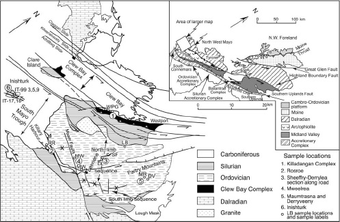
A dramatic example of the usefulness of heavy minerals comes from Ireland’s South Mayo trough. This area of Ordovician volcanic and sedimentary rocks sits within a complex collage of rocks shuffled around by the Caledonian orogeny. It is broadly a syncline in shape, with two sets of outcrops – a northern and a southern limb.

Location of South Mayo Trough. Figure 1 from Mange et al 2010

Location of South Mayo Trough. Figure 1 from Mange et al. (2010)

Today, the South Mayo Trough sits within the Eurasian plate, but it was born in the middle of an ocean that no longer exists.

All at sea

The oldest sediments are found in the Letterbrock formation3.  The sediment matches what you would expect from erosion of the rocks found immediately north of the basin, the Killadangan formation which has been interpreted as an accretionary prism.

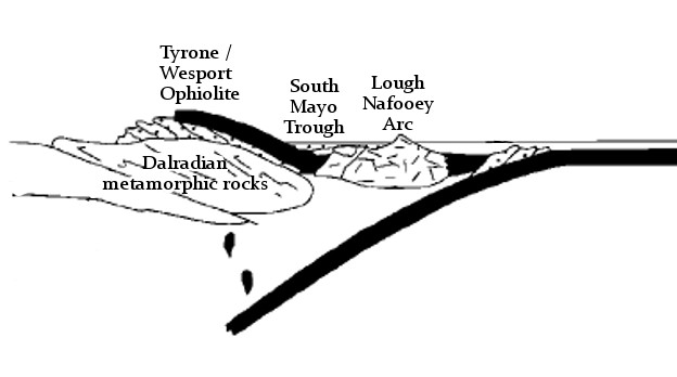
In the south, the sediments correlate with the Lough Nafooey group of volcanic rocks. These formed as part of an oceanic island arc within the Iapetus ocean. Together, this evidence suggests the South Mayo Trough formed as a forearc basin.

South Mayo Trough forming within the Iapetus ocean

South Mayo Trough forming within the Iapetus ocean

The oldest sediments in the north also includes ‘ophiolite detritus’ – grains such as epidote and chromite that are typical of the erosion of oceanic crust. In the overlying Derrymore and Sheefry the ophiolitic debris becomes dominant – serpentine and chromite are so abundant that some beds are unusually heavy and have a ‘soapy’ feel. The volume of chromite increases up through the Sheefry and its chemistry becomes richer in Cr/Ni/Mg. 

Grains of mica and zircon in these rocks have been dated. They show a variety of ages, all Precambrian, consistent with being derived from the old rocks of the Laurentian margin.

During this time, the volcanic rocks of the south show a change in composition. The earliest rocks are basaltic. Patterns of rare earth elements and other geochemical signatures are consistent with an oceanic island-arc origin (only oceanic crust involved). Over time the rocks become progressively more acidic, moving into andesitic and ultimately rhyolitic compositions. Rare earth elements show that the tectonic environment changes. Initially the oceanic island arc magmas were formed from melting of oceanic crust only. Progressively, more and more melt is derived from melting of Laurentian continental crust.

Collision but no mountains

The volcanic rocks therefore record that subduction zone has run out of oceanic crust – the island arc has collided into the continent – the leading edge of which was subducted and melted to feed the volcanic arc.

At the same time as these events recorded in the South Mayo trough, sediments formed on the edge of the Laurentian continent  the Dalradian Supergroup) were being buried, heated and deformed in Grampian/Taconic orogeny. The sediments were buried underneath the oceanic crust (ophiolite) and oceanic island arc as they collided with the continent.

South Mayo trough as part of arc-continent collision

South Mayo trough as part of arc-continent collision

This implies the South Mayo trough itself was part of the upper plate, thrust onto the continent. The work orogeny is synonymous with mountain building, but here we have a sedimentary basin sitting on top of an orogeny, not only being preserved, but continuing to fill up with sediment. Various explanations have been given: the subducting slab and the ophiolitic upper nappe may have been unusually dense. The sedimentary basin, packed with serpentine and chromite certainly was. The sea-level at this time (mid-Ordovician) was unusually high, between 250-500m higher than at present. It’s possible the South Mayo trough was only plastered onto the side of the orogen, not thrusted completely over the top.

Whatever the reasons we should certainly be grateful that the sedimentary tape recorder was preserved. It was still rolling and about to record some more remarkable events.

A  change of direction

Plate tectonics is a global phenomena. The closure of the subduction zone and the arc collision did not stop the overall convergence between the Laurentian continent and the Iapetan oceanic crust. In time another subduction zone formed, this time putting oceanic crust underneath the continent – a change of direction.

While this flip of subduction was taking place, conditions in the South Mayo trough at first didn’t change. The Lower Derrylea formation contains ophiolite debris from north (chrome spinel and purple zircons) and arc debris (clear zircons) from the south.

Diagram showing links events in the South Mayo Trough and other areas. Supporting Appendix. Key to columns: A, Western Newfoundland Ordovician Shelf; B, Notre Dame Bay arc stratigraphy; C, West Newfoundland ophiolites; D, Notre Dame arc ages; E, Quebec.New England; F, Scottish Highlands; G, Achill; H, Connemara; I, Clew Bay Complex; J, Scottish ophiolites; K, north limb of SMT; L, south limb of SMT (thicknesses in K and L in meters), detrital mica ages [71] in SMT; M, Derryveeny; N, Mweelrea; O, Derrylea; P, Rosroe; Q, Maumtrasna; R, Sheefry; S, Southern Uplands accretionary prism; T, detrital mica ages [70] in Southern Uplands accretionary prism.

Diagram showing links events in the South Mayo Trough and other areas. See Dewey (2005) for detailed explanation

Suddenly, around 466 million years ago, while the upper Derrylea formation was being deposited, a massive change occurs. Starting with a single massive thick turbidite bed there is an influx of different heavy minerals. In comes staurolite, almandine and chloritoid, along with floods of muscovite. These are metamorphic minerals and they show Ordovician ages – they come from the metamorphic rocks of the Dalradian.

Dating of these minerals shows that they were hot only 5-10 million years before they ended up as sand grains. Such rapid unroofing of metamorphic rocks suggests something more potent that erosion is at work. The Dalradian rocks in this area show rapid cooling at this time also suggesting something was bringing them rapidly towards the surface. What tectonic mechanisms could explain this?

With the creation of a new subduction zone to the south, the force of the converging plates was no longer supporting the thickened rocks of Taconic/Grampian orogeny. Now in a back-arc position, they extended rapidly. Major faults rapidly brought deep rocks to the surface sending metamorphic minerals cascading into the South Mayo Trough.

Once the Dalradian debris starts flowing, there are no more dramatic changes in the recording. It ends fairly soon after – the whole area is covered by unconformable Silurian sediments – but there is one more thing.

By 464Ma, the whole area is now in an ‘Andean’ type of tectonic environment, with intermediate vulcanism associated with the new subduction zone. This is recorded as ignimbrite layers in the South Mayo Trough, but also as granite intrusions within the nearby Connemara terrane. Once more we are able to make links between the surface and deep processes.

This is what makes these techniques and these rocks, so special. Linking surface to deep processes, resolving timescales to within a million years – these are very powerful ways of understanding how the earth really works.

References

Dewey J.F. (2005). Inaugural Article: Orogeny can be very short, Proceedings of the National Academy of Sciences, 102 (43) 15286-15293. DOI:
Mange M., Idleman B., Yin Q.Z., Hidaka H. & Dewey J. (2010). Detrital heavy minerals, white mica and zircon geochronology in the Ordovician South Mayo Trough, western Ireland: signatures of the Laurentian basement and the Grampian orogeny, Journal of the Geological Society, 167 (6) 1147-1160. DOI:
Brown D., Ryan P.D., Ryan P.D. & Dewey J.F. (2011). Arc-continent collision in the Ordovician of western Ireland: stratigraphic, structural, and metamorphic evolution, Arc-Continent Collision, 373-401. DOI: