Assynt’s etched landscape

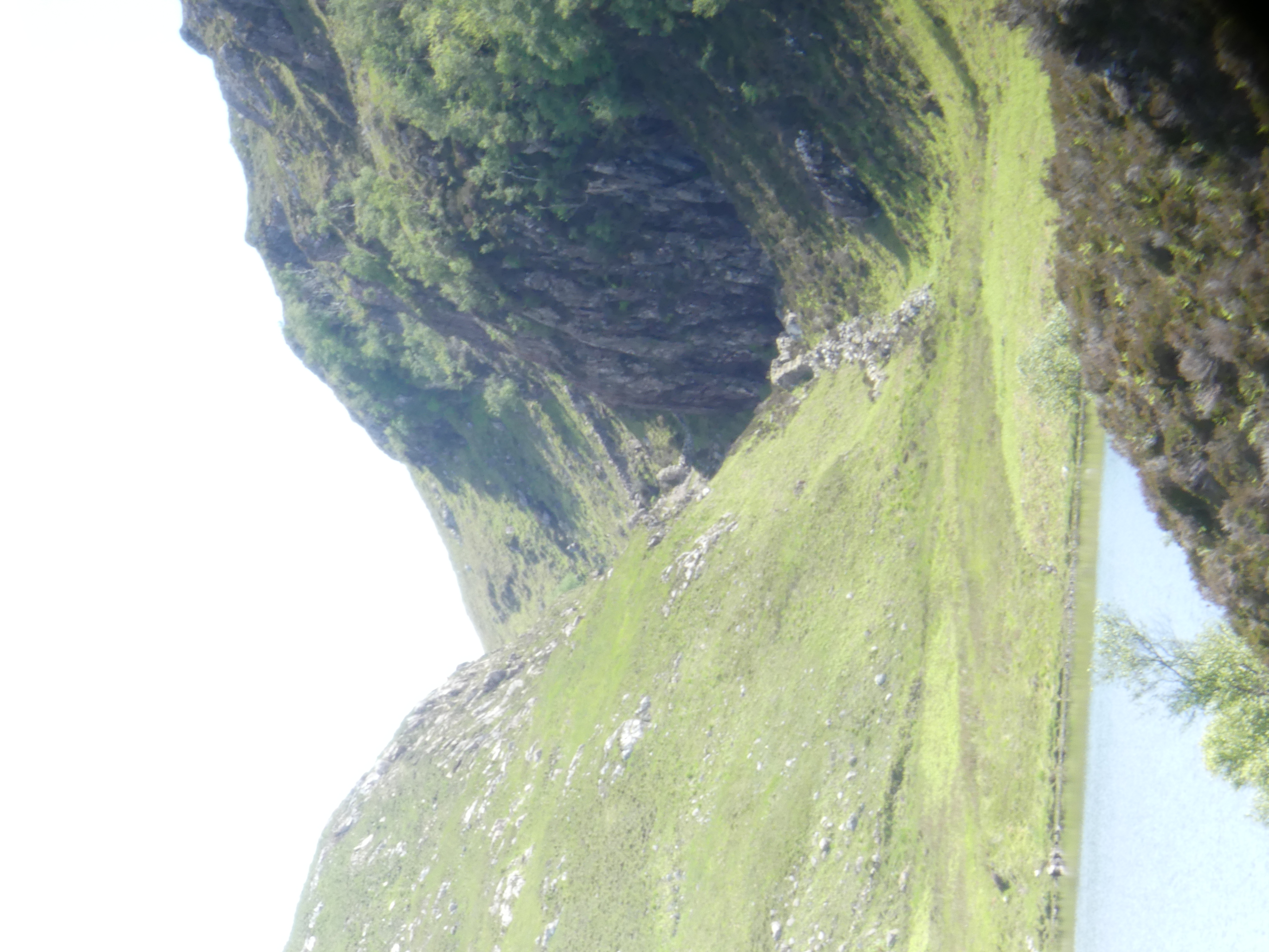
Some place names describe the shape of landscape. South east of Lochinver lie Cnoc a Mhuilinn (“Mill Hill”), Gleann Sgoilte (“Cleft Glen”) and Gleannan na Gaoithe (“Windy Glen”). These are dramatic features where the land has been cleaved, leaving narrow slots where the wind howls and narrow fast rivers make mill streams.

Gleannan na Gaoithe, looking ESE

These dramatic features are all aligned in space. How did they form? A paper from 1956 maps them out and links them to a now vanished lake they call ‘Loch Suilven’. Using “an
ex-R.A.F. bubble-sextant in conjunction with a box-sextant
“, Alex J. Boyd of Inverkirkaig carefully mapped the fossil beaches left behind by this Loch. From this work it is clear that water levels were once much higher. He inferred that the lake once drained via our dramatic glens, until the modern Inverkirkaig river breached the lake and drained it, separating it out into Fionn Loch, Loch Veyatie and others.

Location map. Figure 2 from Boyd (1965).

The picture is complicated by ice. This landscape is haunted by the Ice Age and any carving into the ground could have been done by ice as well of water. Glacial melt water channels are features formed by the flow of ice close to glaciers. Water beneath may flow under pressure, or ice may dam rivers, or melt suddenly to create large volumes of water. Under these conditions, channels may be cut by catastrophic flood events.

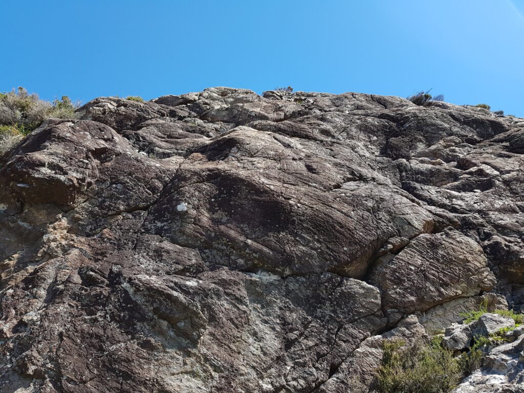
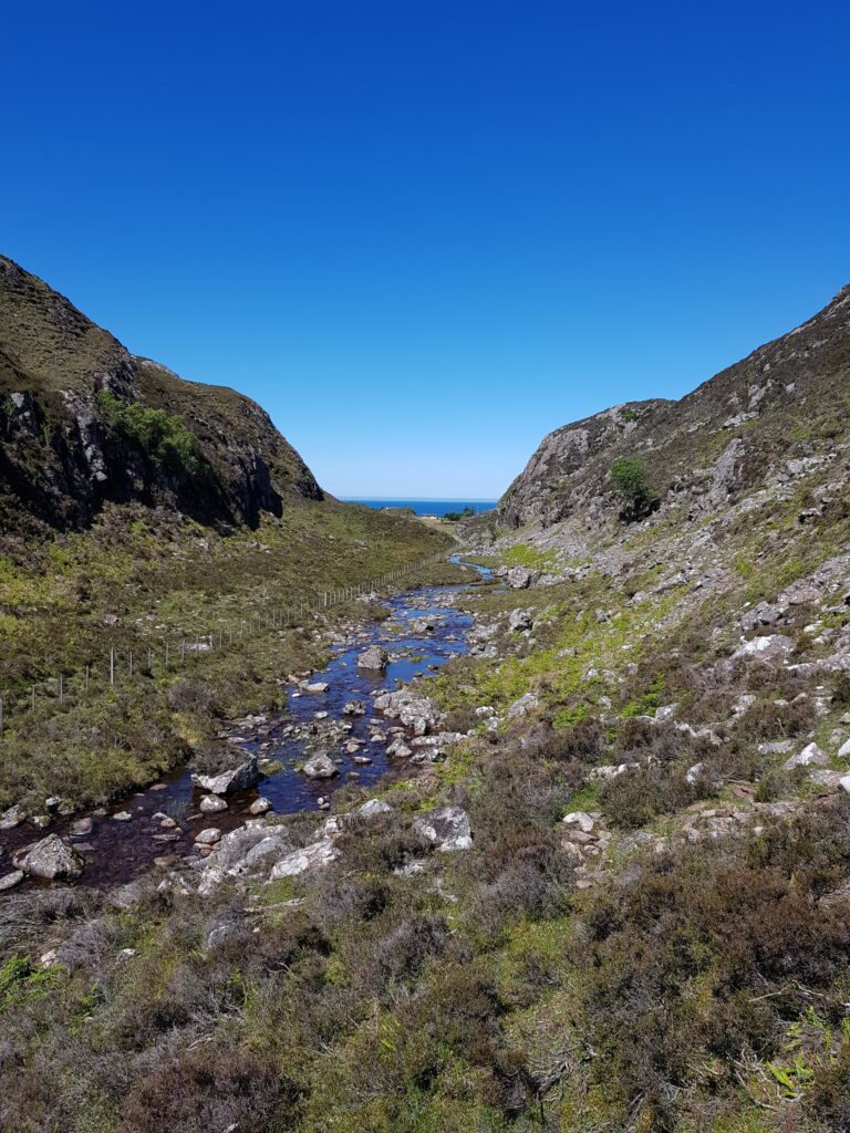
Tracing the western edge of the area, around Badnaban (place of the women) Boyd reports “rounded boulders” of large size that suggest the water flow was of “torrential character”. High up, the walls of the channel below Cnoc a Mhuilinn have a polished appearance with scalloped shapes. The British Geological Survey interpret these as S-forms and P-forms and call the structure a glacial meltwater channel.

View of a rock surface in the glen below Cnoc a Mhuilinn

A brief scan of modern literature suggests that there is no consensus about the precise meaning of these features, but for sure they are consistent with a dramatic flooding event scouring out the channels. Ice flow may also have shaped the glens and both mechanisms may have acted at different times. But maybe what was eroded is more important than how it was done.

Glacial meltwater channel below Cnoc a Mhuilinn

The sculpture within the block

There’s a quote attributed to the sculptor Michelangelo, to the effect that the sculpture is already there within the block of marble, his job is merely to remove the material surrounding it. For this landscape, this may be literally true. We’ve talked of ice and water cutting into the ground, but maybe the most important features were already physically present within the bed rock, waiting to be revealed.

The cnoc and lochan landscape is an extremely distinctive feature of Lewisian gneiss areas. A similar landscape exists in Connemara on the deformed igneous rocks of Roundstone Bog. The writer Tim Robinson describes this landscape as “frightened”. It’s a largely random distribution of lochs and hills, straight lines appearing where it is cut by geological faults, breaks in the rock that weaken it.

Maarten Krabbendam and Tom Bradwell (of the British Geological Survey) have reviewed the cnoc and lochan terrane in Sutherland and conclude that its distinctive roughness is not a direct product of glacial erosion.

They review similar landscapes in other countries and note that they are a feature of rock type, not of erosion style. They compare the Assynt area with similar terrane in Namibia, where erosion is caused by wind-blown sand rather than ice. They show that the shape of the landscape is mostly controlled by chemical weathering, that weakens solid rock into weak ‘saprolite’. The role of erosion, whether scouring by ice or glacial meltwater, is to remove the saprolite, leaving the harder rock behind.

Chemical erosion is highly sensitive to rock type. The Lewisian Gneiss is cross-cut by vertical sheets of rock called dykes. One particular dyke (400 million years younger than the other Scourie dykes) is rich in olivine, a mineral too chemically delicate to last long at the surface. This dyke easily rots into saprolite, forming deep zones of soft rock. The glacial meltwater channel below Cnoc a Mhuilinn precisely follows this dyke; its location was determined not by the ephemeral flow of ice or water, but by events 1,992,000,000 years ago. Gleann Sgoilte was cut into another dyke and Gleannan na Gaoithe formed along a later shear zone, full of fractured and altered rock.

This pattern is common across the whole of Assynt, wherever Lewisian Gneiss is found. These remarkable glens may be more dramatic than most, thanks to glacial floods, but these were simply picking out the bones of the rock. This landscape was etched rather than scraped.

Looking out for the red rocks

Author Tim Robinson spent countless hours in the west of Ireland, unearthing local Irish-language place names. Some are anchored in myth and poetry, referring to miracle-working saints or Celtic Gods. Most though are prosaic, being linked to people’s names, local plants or animals and – occasionally – geological features.

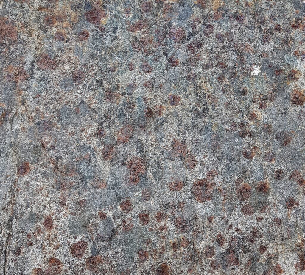
Fàire nan Clach Ruadha is one of the countless hills within Assynt’s central wilderness, just another small summit amid the craggy wastes of the Cnoc and Lochan landscape. Once I’d roughly translated it as ‘red stone lookout’, I knew I had to pay a visit. Secretly I was hoping the ‘red rocks’ would be garnet-rich, as is often the case within the Lewisian Gneiss.

The sort of red rocks I was hoping for. Garnet-rich Lewisian Gneiss from Scourie

On a perfect June day I went in search of the physical realities behind the name. Let’s start with ‘Fàire’. The online resources I’ve used translate this as ‘watch, lookout’, which implies someone once sat on the top of the hill, keeping an eye out for something. This could have been livestock: sheep or cattle. Subsistence farming practices saw animals brought into the interior during the Summer, to make use of the good grazing found here and keep them away from arable crops. Ruins out here are often Shielings, simple buildings built for Summer use only. We are not far here from some and the hill offers good all-round views of the immediate area.

So maybe previous visitors were enjoying themselves, having a relaxed Summer just like me. Tim Robinson translates the Irish phrase for a nostalgic return: “Cuairt an lao ar an athbhuaile” as “the calf’s visit to the old milking place”, a reference to the practice of taking livestock into the hills in Summer. This booleying (to use the Irish terminology) lasted until the 1930s in Ireland and Robinson quotes some idyllic sounding memories of those times.

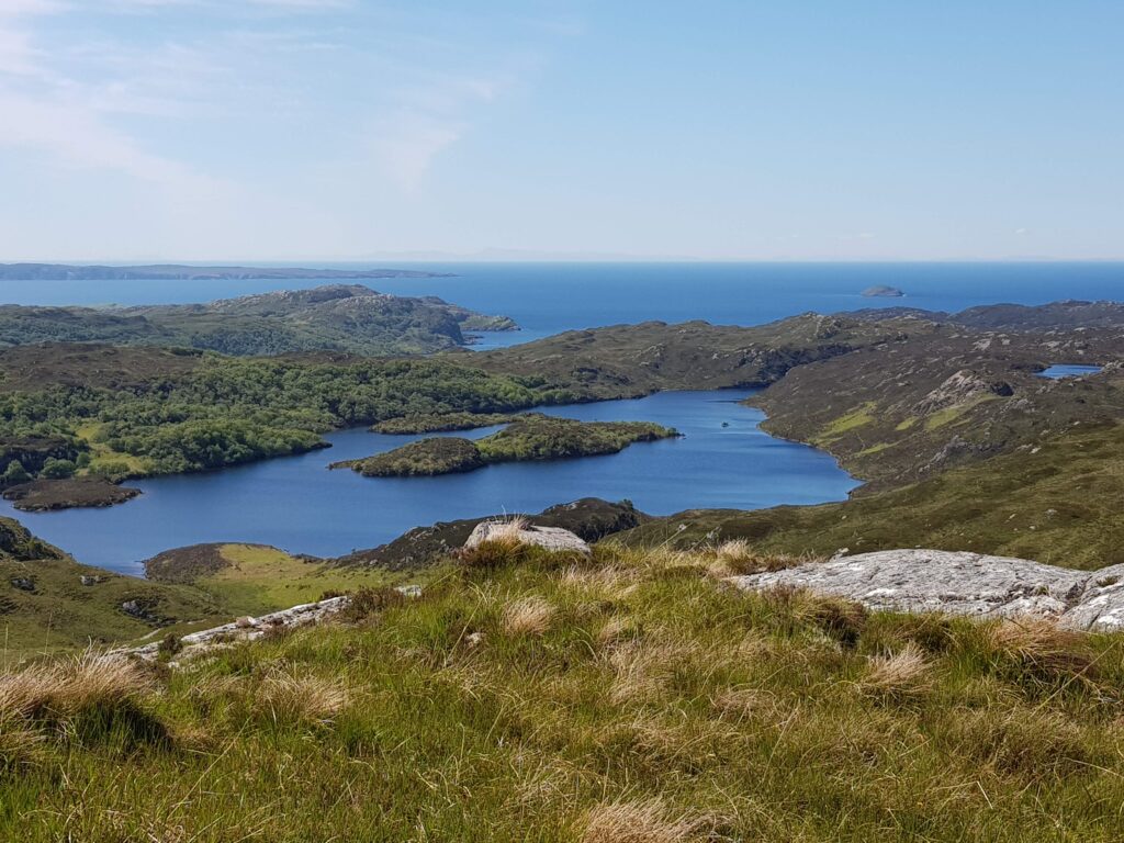
View west from Fàire nan Clach Ruadha, out to sea.

There is another possibility. Walking inland, this hill is the first to give really distant views of the sea, to raise you above this land’s crinkly corrugations. In the photo above you can see the Achiltibuie peninsula, top left, about 10 km distant. The faint smudges of the Outer Hebrides are clearly visible to the naked eye. Maybe this was a place to look out for ships. There are Norse-inflected names are present near here – Suilven and Inverkirkaig for example. Could a lookout here once have run off in terror, sprinting to give advance warning of a hostile Viking attack? On a glorious June day it seems like an impossible idea. Surely a dot on the horizon would cause joyful anticipation of a returning loved one, home from the sea.

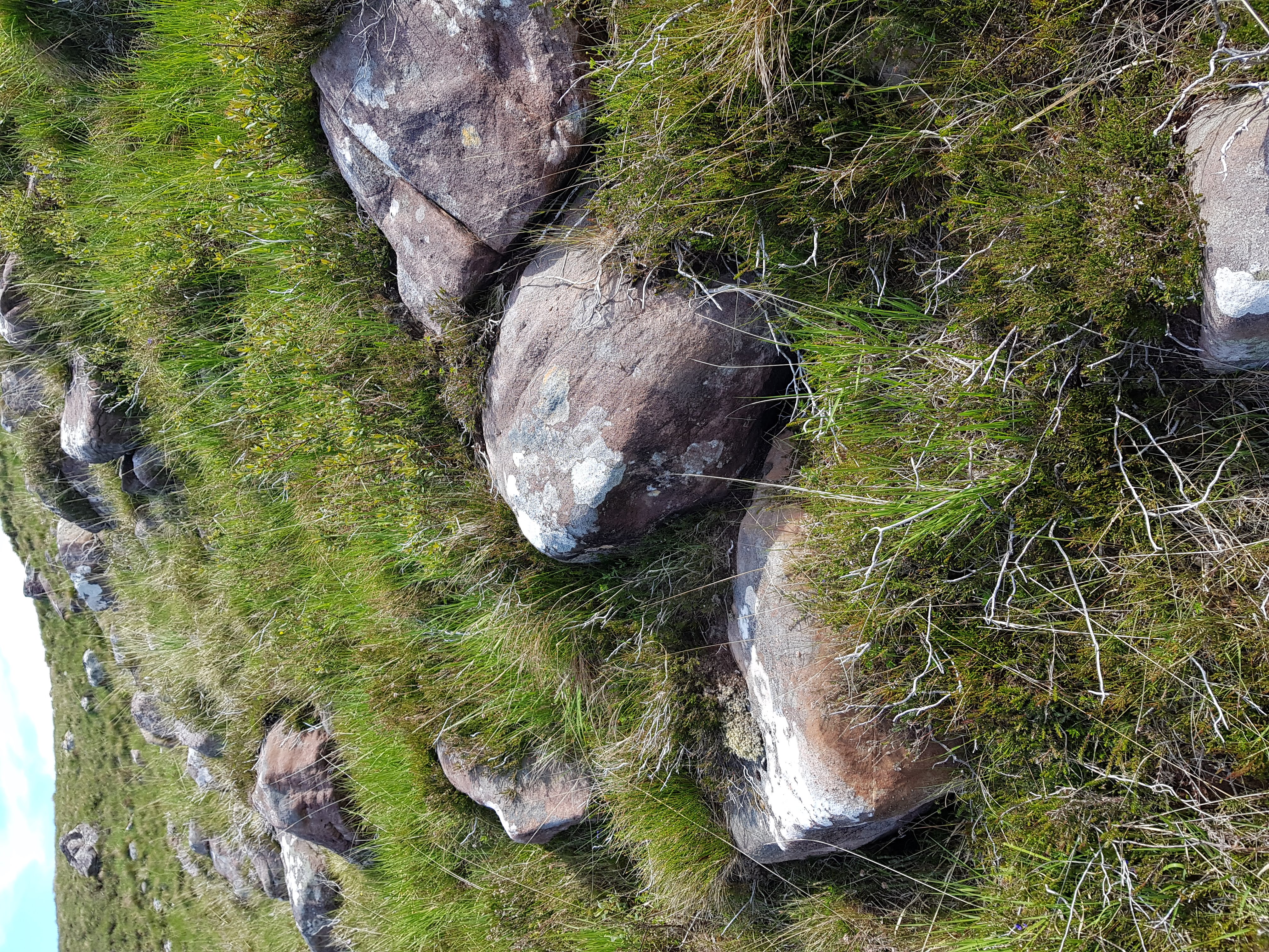
What of the “red rocks”? While the bedrock of Fàire nan Clach Ruadha is made of Lewisian Gneiss, blocks of red Torridonian sandstone are found in great abundance here littering the surface. Some sit proud on the top of the hill, but the most abundant areas are on west-facing slopes.

Red rocks
Red rocks of Torridonian sandstone

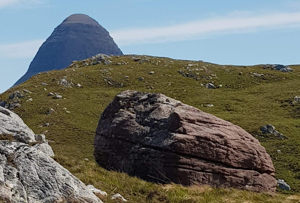
As for much of Assynt, photos taken from here become dominated by the great charismatic peaks of Suilven and Stac Pollaigh. Like being photo-bombed by a celebrity, they immediately become the focus of the image, demanding your attention through sheer charisma. These peaks are also made of Torridonian sandstone, so on Fàire nan Clach Ruadha it feels like they are proud parents, peering down upon their tiny offspring.

Suilven peering down at its little baby mountain

Imagine this is how mountains form. The big parent mountain silently urging its offspring to grow up big and strong. Perhaps they are like sharks, the biggest feasting off their siblings in a race to reach adult size. I could be in the midst of a massacre, too slow to register on human timescales.

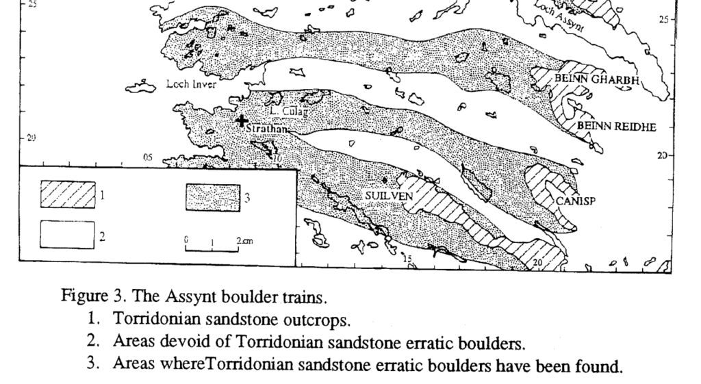
Of course this is actually how mountains die. Each block was plucked from the side of Suilven by ice and left behind by a now vanished ice sheet. We know this, as people have laboriously mapped the location of these ‘boulder trains’ of Torridonian sandstone, showing a clear link.

Image from Lawson (1995).
Fàire nan Clach Ruadha is within the boulder train coming from Suilven

This academic paper ends with a great acknowledgements section, thanking “the unstinting, though often forced, efforts of a large number of A level Geography students ….helped in the plotting… across this knurled and unyielding landscape, often in the most unhelpful of weather“.

Place names are echoes of how past generations have engaged with a landscape, a reminder that our feet are not the first to tread these rocks. Subsistence farmers on a lazy Summer’s day; somebody anxiously scanning the sea; wet and grumpy teenagers; maybe all have noticed these red rocks before me.

A refolded fold from Scotland

Standing on the shores of Loch nan Uamh I was feeling distracted. There was a lot to attend to. Behind me was a flat strip of grass, growing on a beach deposit now left high and dry by the crust’s slow straightening of its spine after the weight of a huge ice cap melted away. Perched above the fossil beach was a Victorian country house where incredibly brave people from across Europe had trained before being dropped into Nazi-occupied Europe to wreak righteous havoc.  To my left sits an Iron age hill fort and straight ahead a sublime view demanding I pay attention to its wild empty peninsulas, small forested islands and wide rolling sweep, all under a cloudless sky. The drift of my thoughts towards why this landscape is so wild – heartless landlords and ‘improvement’ leading to clearance and gaelic songs sadly sung on a ship to Canada – is interrupted by my family. Not unreasonably they want me to stop staring into space and attend to their games on the rocky beach.

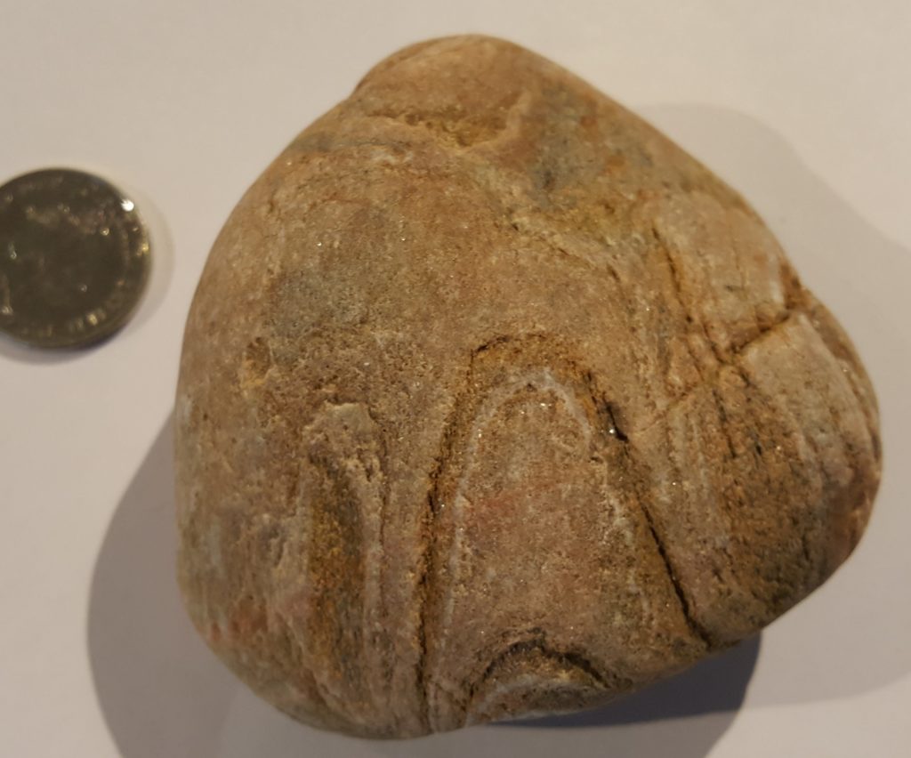
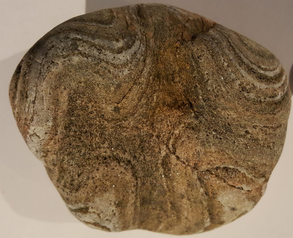
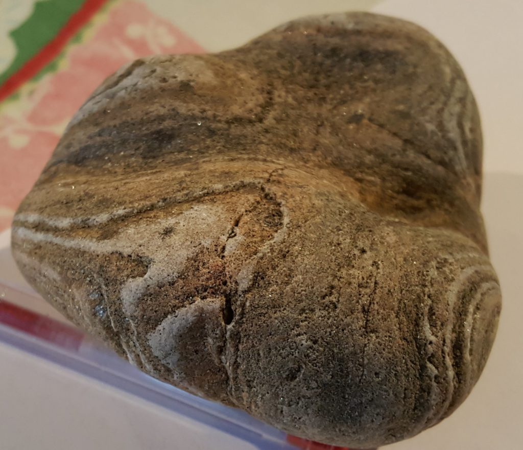
Fatherly duties still leave time for me to assume the geologist’s pose and stare at the ground, assessing the cobbles at my feet. I snaffle a nice bit of granite first. Then a nice piece of pinkish folded quartzite catches my eye and slips into a pocket to be forgotten as the glorious day rolls on.

Let’s have a look at it.

You can see how it caught my eye. Just short of a billion years ago it was formed as different layers of sand, some nearly pure quartz, others more muddy. It’s since been heated and squashed within the earth. The quartz is still quartz but the mud is now shiny mica.

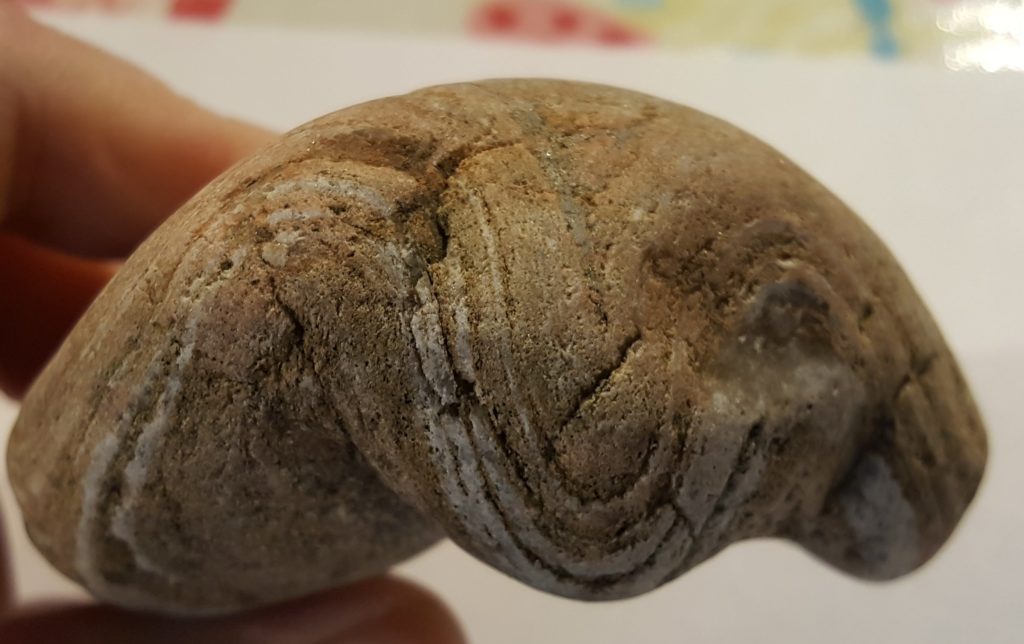
What were once flat layers 1  are now folded. The pattern we see is the intersection of a 3D fold with the complex rounded surface of the pebble. Call the image above as a view of the top of the pebble. Let’s rotate it round (it sits beautifully in the hand, like a heavy cricket ball) and look at one of the sides.
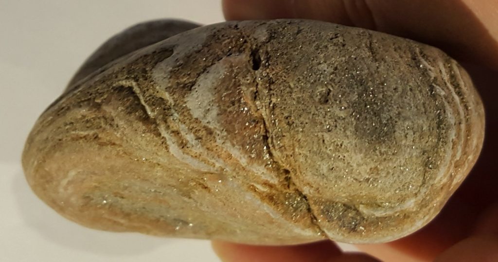
These sigmoidal shapes are classic folds. You can almost visualise the rock sitting in a clamp being squashed horizontally to turn flat lines into wavy.

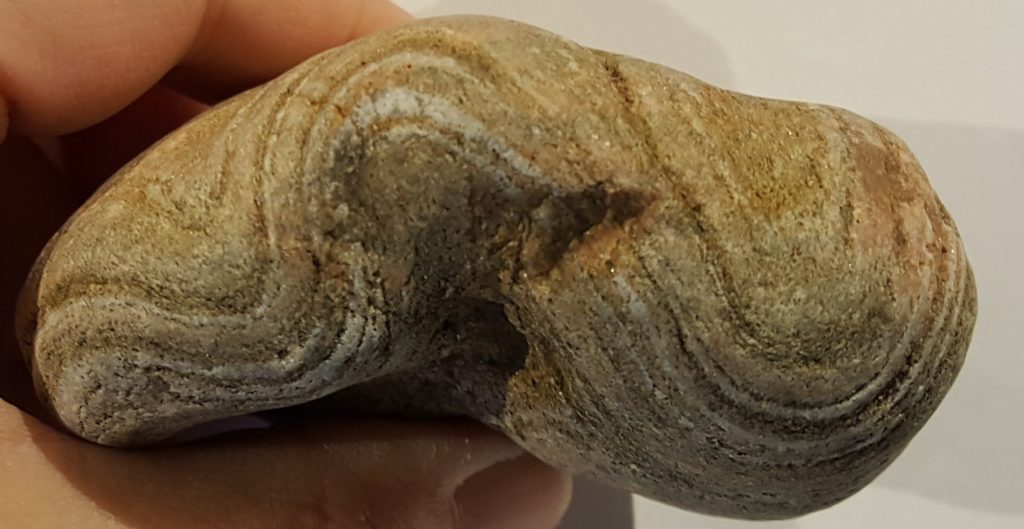
Rotate the sample 180 degrees around  a vertical axis to see the other side of the sample and you see the same folds coming out of the other side of the rock.


Looks simple. But appearances can be deceptive. Let’s rotate the sample to look at its underside (the side my thumb is holding in the picture above).


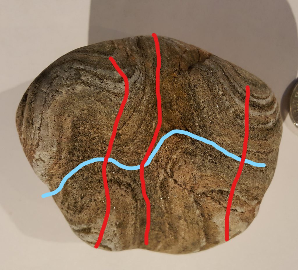
At the top of this photo you can see some of the edge in the preceding picture. So the folds we’ve seen before have their crests and troughs running vertically through the image. You can see that, but not just that. The darker layer sitting in the middle of the shot runs from top to bottom, marking a trough in the folding, but it is forming a rough cross shape, not a single line as I would expect.

There are two sets of folding in this sample. I’ll try and annotate that for you.

In red I’ve drawn most of the troughs and peaks of the main folds. The ones we’ve seen now from three angles. The blue line shows what I reckon is an earlier fold, where the crest of the trough is itself folded by the red folding.

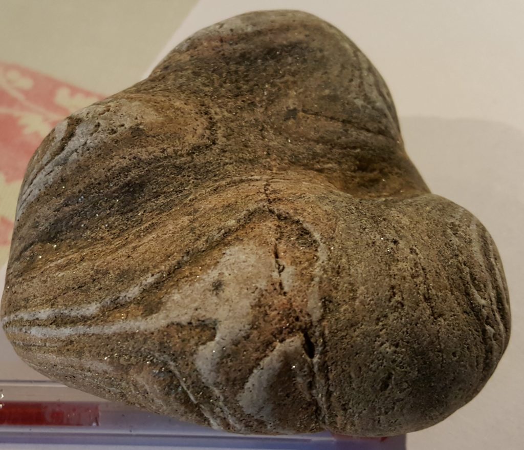
Here’s a view looking at the side again, the edge on the right side above. It’s at an angle of 90 degrees to the other side views. We are looking down on a trough shape made by the earlier blue folding, now bent around by the red folds.

Here are some oblique views in the same direction, that makes the saddle shape formed by the two sets of folding more obvious. This stuff is hard to see from photos. It’s easier to visualise the three-dimensional patterns when you’ve got the sample in your hand, but even then I didn’t notice (distracted as I was) the full complexity when I first picked it off the beach.

The rock sample is probably from the local Moine rocks, where refolded folds are common. There’s a bigger and more complicated example in the hills above where I collected this a tale of past oceans opening and closing, lost continents forming and splitting. But we’ll come to this in a future post.

The many metamorphoses of the Moine

In a companion post I introduced you to a metamorphic rock with an apparently simple history. Using traditional geological techniques on this single outcrop can’t reveal the full history of the area, so this post will attempt summarise the latest research. In short1 the more closely you look, the more complicated things become.

The many Phases of the Caledonian

When I was young, things were simple. The metamorphic rocks of the Scottish Highlands, (the Moine and Dalradian) were affected the by Caledonian orogeny caused by the closing of the Iapetus Ocean. A nice simple piece of continental collision with classic Barrovian metamorphism and some splendid deformation. Nowadays, thanks to isotopic dating we know that things are much more complicated. Much much more.
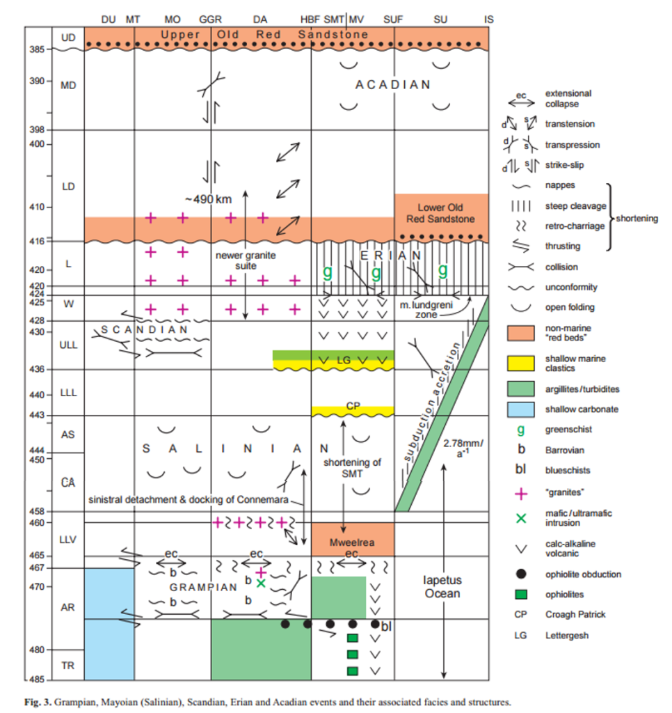
From Dewey et al 2015. Our rocks is from the Moine, which is represented by the second column from the left

From Dewey et al 2015. Our rock is from the Moine, which is represented by the second column from the left

The diagram above represents the latest thinking about what the Caledonian Orogeny consisted of. Instead of a single continuous event we can recognise 3 distinct events each of which is associated with deformation and the growth of metamorphic minerals.

It comes from a paper that is a grand summary covering the entire British Isles. For today, let’s just focus on the second column from left, with Mo for Moine at the top. Start from the bottom and move up in time. First we have the Grampian event around 470 million years ago. It was caused by a collision between the edge of the Laurentian continent and an volcanic arc, with a piece of oceanic crust (an ophiolite) thrown in for good measure. I’ve written about this in detail elsewhere.

The second event, marked in the diagram as Salinian is less well understood. In the text Dewey et al. also call it the Mayoian as the deformation is well represented in County Mayo in Ireland (also perhaps because this was John Dewey’s PhD field area and he’s long been in love with the place). The alternative name Salinian (or Salinic) suggests a link with events of the same age in rocks from Newfoundland (which before the Atlantic was not far away). Dewey et al. speculate it may have been caused by subduction slab flattening (like the Laramide orogen in North America).

Bird et al. (2013) recognises the same event, dating growth of garnets at this time in rocks only about 25 km away from our rock sample. They call the event “Grampian II”, which is less poetic but avoids potentially incorrect correlations with other areas. Their proposed cause is the collision of a small fragment of crust or arc with Laurentia.

The final event is called the Scandian, which represents the final closure of the Iapetus ocean. In this northerly portion of the British Isles, this means a collision between the ancient continents of Laurentia (most of modern day North America, plus a sliver of NW Scotland) and Baltica (the ancient piece of crust that sits under modern day Scandinavia). Further north in the Moine, the dominant deformation fabrics are of this age, including the famous Moine Thrust.
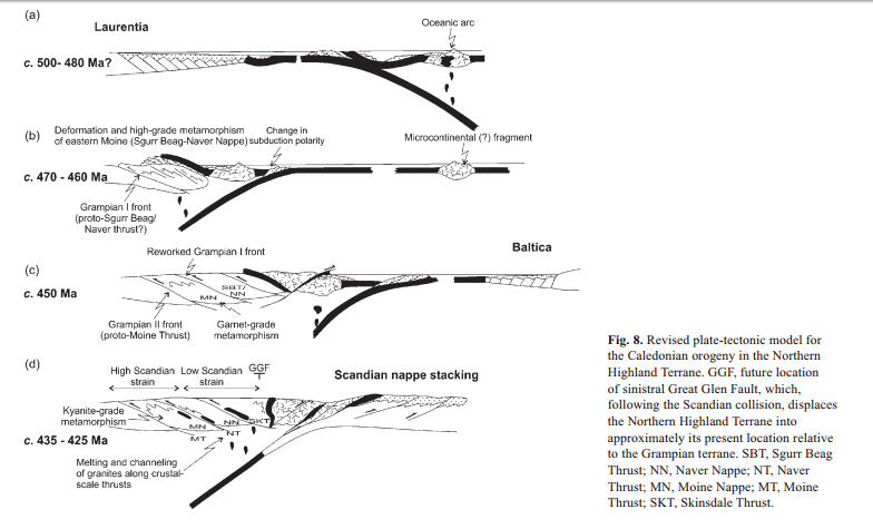
Figure 5 from Bird et al

Figure 5 from Bird et al. (2013) showing plate tectonic cross-sections at various times – b) is Grampian, c) Grampian II and d) is Scandian.

With one eye on the diagram above, lets describe those 3 events in terms of plate tectonics. First the Iapetus ocean opens up. Our rock is on one side, part of a plate called Laurentia. The ocean starts to close, but as it does so if forms an oceanic island arc. Around 470 Ma this collides with Laurentia heating and deforming a bunch of rocks. Twenty million years later, a smaller fragment (maybe like Rockall bank in the modern Atlantic) hits and causes some disturbance. Finally around 430 million years ago the ocean basin closes and messes some rocks up (again).

Which of these events caused the little feldspars to grow in my rocks sample? I don’t know for certain and what’s worse, it might not be any of them – it might be an older event.

When the Iapetus ocean opened at the beginning of my little story, the Moine rocks had already been deformed and heated at least twice before.

Before Iapetus

Cawood et al. (2012) is my main source of information here. Let’s cut to the chase and go straight for the summary diagram.cawood-figure
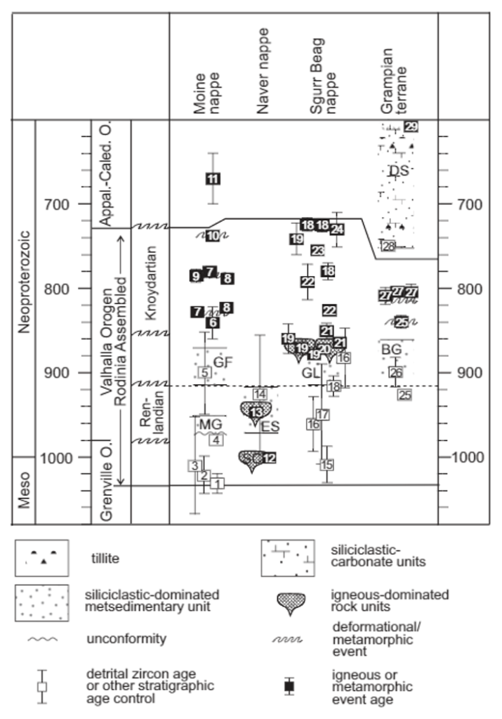
This is a similar diagram to the Dewey one above only it shows the actual dates from individual rocks. Similar dates exist for the younger events, but they are not shown on the first diagram.

I’ve reached my quota of explaining orogenies for the day. Let’s just say that there are two more here (Renlandian and Knoydartian), both poorly understood but both opportunities for my rock sample to have grown its feldspars.

What does it all mean?

What should we make of all this complexity? A few thoughts follow.

Firstly, the practice of correlating metamorphic or deformation events between different areas should be used with care – it can be completely wrong. The dominant fabric and metamorphic event in the northern Moine is Scandian in age, but in places further south it is Grampian II / Mayoian in age, despite looking very similar in thin section. Traditional analysis has correlated the two, but modern dating techniques show then to have formed at different times.

Secondly, if metamorphic minerals grew in the Moine at five different times, why doesn’t my rock show five sets of mineral growth? There are many possible reasons, but most importantly it’s likely that not all episodes affected all of the Moine – with the Scandian for example is possible that my area was too far from the action to be affected. Either geographically or possible because it was too high up in the crust.

It’s possible that later episodes of growth have completely destroyed earlier mineral grains, wiping the evidence away and making the rock’s history look simple. But we only know about each episode because we’ve dated a mineral grain that has remained relatively unscathed since. Rocks nearby still have visible sedimentary features retained so there are limits to how much we can explain this way.

Some believe that metamorphic events may transform relatively small volumes of rock because heating or fluid flow is localised.  Outside of these areas, dry rocks are heated but don’t recrystallise – don’t change. A piece of pottery is a form of metamorphic rock transformed from mud, but heating it up again doesn’t cause a further dramatic change.  Maybe my rock was transformed early on when it was rich in water from metamorphic reactions, but when heated up at a later date, little changed.

A third topic is around structure. There are no complex structures in my rock sample and its outcrop, but the Moine as a whole is a classic locality for refolded folds, which are exactly what you’d expect in an area deformed multiple times. Individual areas may have up to 4 different phases of folding, but the relationship between these and each orogeny is not simple. Bird et al. discuss this topic (about another area) and suggest fabrics or folds may be composite, that “structures may have initially developed as tight to open structures during the Late Ordovician event, and were later strongly modified into their present tight to isoclinal, sheath-like geometry during intense shear associated with Scandian nappe stacking“.

Many of discussions around metamorphism are relevant here as well. Let’s remember the undeformed sedimentary features in rocks nearby. They may now be vertical, but they are otherwise little deformed.

So how old are these blasted feldspars anyway?

Krabbendam et al. (2014), studying Moine rocks not far north of mine regard early structures (D1) as being pre-Grampian and later ones – and the main phase of mineral growth – as being Grampian II in age.

So that’s the most likely answer for my rock. Whatever happened in the pre-Grampian events is lost in the mists of time. Those nice big white feldspars grew and were rotated during the Grampian II event and shrugged off the Scandian event without any visible changes.

If you are thinking I’ve made this unnecessarily complicated2 I’ll just point that on a hillside visible from my outcrop there are some of the rocks that were the basement on which the Moine sediments were deposited. These ‘Lewisianoid’3 rocks, now ‘inliers’, or strips of gneiss folded into the Moine metamorphic rocks, have experienced all of the events the Moine has, plus three or more others (Scourian, Laxfordian and Grenvillian4). Here’s a thin section of some, with folded banding, but not looking *that* complicated, considering the 8 different events it’s witnessed.
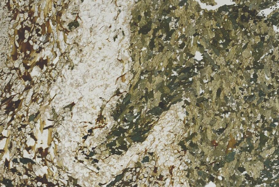
lewisianoid

Life is complicated. Plate tectonics is a continuous process that takes place in three dimensions on a sphere over millions of  years. The fact we can use a bunch of ancient rocks in Scotland to recreate the ancient dance of vanished oceans and transformed continents is a triumph of science, but let’s not be surprised that it is complicated.

REFERENCES

Note that Professor Rob Strachan of Plymouth Portsmouth University is a co-author on nearly all of these papers. His nickname of ‘Captain Caledonides’ is well-earned.

Dewey, J. F., Dalziel, I. W., Reavy, R. J., & Strachan, R. A. (2015). The Neoproterozoic to Mid-Devonian evolution of Scotland: a review and unresolved issues. Scottish Journal of Geology, 51(1), 5-30. doi: 10.1144/sjg2014-007

Bird, A. F., Thirlwall, M. F., Strachan, R. A., & Manning, C. J. (2013). Lu–Hf and Sm–Nd dating of metamorphic garnet: evidence for multiple accretion events during the Caledonian orogeny in Scotland. Journal of the Geological Society, 170(2), 301-317. doi:10.1144/jgs2012-083

Cawood, P. A., Strachan, R. A., Merle, R. E., Millar, I. L., Loewy, S. L., Dalziel, I. W., … & Connelly, J. N. (2015). Neoproterozoic to early Paleozoic extensional and compressional history of East Laurentian margin sequences: The Moine Supergroup, Scottish Caledonides. Geological Society of America Bulletin, 127(3-4), 349-371. doi: 10.1130/B31068.1;

Krabbendam, M., Leslie, A. G., & Goodenough, K. M. (2014). Structure and stratigraphy of the Morar Group in Knoydart, NW Highlands: implications for the history of the Moine Nappe and stratigraphic links between the Moine and Torridonian successions. Scottish Journal of Geology, 50(2), 125-142. doi: 10.1144/sjg2014-002

All diagrams reproduced under fair use policy.