The many ways of understanding mountains

This post is part of my journey into the geology of mountains.

When I’m climbing in mountains I like to take my time of it. The summit is not the point; the journey’s the thing. Direct and fast routes the top are not for me. In that spirit I’m getting diverted into a post that doesn’t really help us get the end of our mountainous journey. Think of it as a detour to get a nice view or an added bonus that adds to our enjoyment and wonder at the variety of mountains.

I’m reading a Geological Society of London special publication at the moment. It’s about mountains, naturally, and I’m going to list out all the geological and geophysical techniques mentioned in it. I’ll start with the obvious, but by the end I’ll hope you’ll share my surprise at the sheer range of different types of evidence being gathered.

The obvious: structural geology is an important technique. You can’t get mountains without deforming rocks and the study of structure, from map-scale to microscopic is essential. I’ve written extensively before about metamorphism and this fine subject is indeed extremely useful when studying mountains; the ability to extract P-T-t paths particularly so.

The geophysical – seismic: for modern mountain belts, such as Tibet, the ability to peer into the depths of the earth is very useful. Seismic techniques have a lot to offer here. First there is the pattern of earthquakes themselves. If a body of rock hosts an earthquake then it is most likely being deformed in a brittle fashion. The pattern of earthquakes with depth can then be used to infer the presence of strong, brittle, rigid rocks versus soft, aseismic, viscously deforming rocks.

More direct field-based seismological studies are of great importance in the study of Tibetan geology. If you place close arrays of seismographs and make your own earthquakes (using dynamite) you can get a lot of data, by looking at the way the returning waves are reflected and refracted through the earth’s surface. This might give you a direct image of an important structure (for example the Moho).

Field-based studies tend to give data on the crustal scale.  For deeper insights, seismic tomography is used. This looks at natural earthquakes and the patterns traced by seismic waves through the earth. This can be used to build up pictures of very deep, very big structures such as subducted crust in the mantle.

There’s more. With enough data, the speed with which seismic waves move through portions of  the earth’s interior can be inferred. In some places this value is different depending on the direction in which the wave was travelling. This anisotropy is interpreted in terms of a preferred orientation of minerals within the rock. We can measure the effect directly in minerals at the surface, which allows us to infer the direction in which the minerals are orientated deep below the ground. Minerals are orientated by ductile deformation so seismic data can let us tell the direction in which rocks are flowing kilometres below the surface.

Other geophysical: the value of gravity at the earth’s surface can be measured and the way this varies sheds light on Geological processes. Measuring gravity over the Himalayas has a fine pedigree, starting with Nineteenth Century observations of how plumb bobs weren’t pulled towards the mountains enough.  The extra mass of rocks above the surface is offset by a greater depth of lighter rocks below: the crust is thicker.

Magnetotelluric studies look at electrical and magnetic fields and can be used to infer the presence of melt (or fluid) beneath the surface.

Apply enough maths and a map of altitude can tell you a lot. For instance the pattern of altitude around recent faults can be used to infer how weak the crust is.

Isotopes: isotopes are useful things, no doubt. Firstly they can tell you how old things are. Cleverly, they can date lots of different events. For a single granite intrusion for example you can use U-Pb in magmatic zircon to tell you the age of intrusion and the same in an ‘inherited’ zircon to tell you the age of the crust that melted. A variety of techniques in mica, apatite and other minerals can then tell you the age at which it cooled through a variety of temperatures. If you want to know how fast rocks are reaching the earth’s surface, this is very useful.

The isotopic composition of Helium in hot springs gives a handle on mantle input to magmatic systems. Cosmogenic nucleides can show how long a rock surface has been, umm, on the surface. Stable isotopes of carbon and oxygen can be used to infer past altitudes.

Indirect: When mountains are eroded, lots of evidence is removed. Not lost though, it is stored in rivers, and river and ocean sediments. Look at the contents of the sediment, in particular heavy mineral contents and the age of zircons and you can tell what was being eroded through time.

Sometimes when intrusions arrive at the surface they contain little pieces of unmelted rock. These xenoliths can give a record of the types of rocks found beneath the surface.

Very indirect: finally the one that makes me smile. Plants. Detailed studies of leaf morphology can be linked to the climatic conditions under which they grew. Apply this to fossil leaves on the Tibetan plateau and you can infer the altitude at which the plants grew. This gives a record of the height of the plateau over time, which is something of great interest.

Phew! The best thing about Geology is the variety. Getting up to speed with contemporary work I’ve been most impressed with the increasingly cross-disciplinary nature of the Earth Sciences. I’ve not even mentioned the variety of numerical modelling techniques that are used, for example. It seems geophysicists and field geologists are working together at last, a pleasant change from the situation I remember in the 1990s.

So, have I missed any? If you know of a technique for studying the geology of mountains that I’ve missed, let me know.

Continental tectonics

This post is part of my journey into the geology of mountains.

Plate tectonics is one of the most successful scientific concepts of the Twentieth Century. It revolutionised the study of the Earth and is one of the few cases where the term paradigm shift can correctly be used.

The theory describes the earth in terms of a small number of rigid plates, whose motion can be described as a rotation on the surface of the earth. Plate boundaries, such as subduction zones or mid-ocean ridges are where these plates move relative to each other. For oceanic plates this description is well-nigh perfect; the zone of deformation at the plate boundary is narrow.

Continents are different. On the broad scale, no difference. The relative motion of Siberia with the lowlands of India can be described accurately by the relative movement of the two tectonic plates, with a rate of convergence of c. 60 mm/yr. Anywhere in between though, things are more complicated. There are major thrusts at the base of the Himalaya, that look like a classic plate boundary, but these only account for about a third of the convergence. The rest of the movement is distributed throughout the Himalayas and the Tibetan Plateau behind it. This can be confirmed by direct GPS measurements. California is another example of this. The strike-slip movement of the Pacific plate relative to North America is distributed across most of California, as confirmed by direct measurement.

So, if a plate boundary can cover 1000s of kilometres and classic plate tectonics does not describe what is going on in these diffuse plate boundaries, then it is not such a useful concept when studying mountain belts. This realisation led to the creation of the term continental tectonics in the 1980s.

Continental tectonics is a general term covering concepts that attempt to describe the behaviour of broad deforming areas of continental crust. So how to get a handle on this behaviour? One approach is to think about areas where the zone of deformation between plates is very wide. The best example is Tibet.

The Himalayas are not important – What’s the most remarkable geographic feature of the Tibet/Nepal area? You probably thought of Mount Everest (to use the western name) or the larger set of 14 peaks that are over 8000m in height across the Himalayan mountain belt. I disagree. The Himalayas are the more glamorous, but actually the Tibetan plateau is the more remarkable feature.

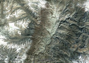
Here’s a cross section of the Himalayas, generated from Google Earth, looking east:

Impressive, most definitely, but here it is again in context.

Same general direction, but note the horizontal scale is 10x longer. The maximum height is lower, but more realistic. The first cross-section I deliberately aimed for the Everest region, trying to get a large height, for the second I just crossed the Himalaya at no particular point.

Not so impressive now. The big mountains are in the Himalayas, but on average they are just the front edge of the Tibetan Plateau. The geology of the Himalayas could be viewed as a narrow plate boundary (lots of thrusting, sequence from Indian through to Asian rocks). What is hard to explain is why the Tibetan Plateau exists at all. Even more mysterious is the fact that recent faults in Tibet are extensional! To see extensional faults, where things are pulling apart, in a large area within a major compressional zone is rather counter-intuitive.

Thak Khola Graben, Mustang, Nepal.

Many Earth Scientists have tried to understand Tibet, some have turned to mathematics, some to plasticine.

The extrusion model – One approach is to say that the concept of rigid plates still applies, it just gets more complicated. So, perhaps the area between Siberia and the Indian plains is made up of a jostling series of microplates, a finite number of rigid portions of crust. Clearly on one level, this is true. The only explanations I’ve seen of the geography north of Tibet (moving north, the Tarim Basin and then the Tien Shan mountain range) rely on the crust underlying Tibet having different properties to that underlying the Tarim Basin. Simply put, Tibet is soft and gets deformed into mountains, whereas the Tarim Basin crust is strong and stays rigid. Recent evidence of subduction of Tarim Basin crust underneath Tibet supports this.

One microplate model of Tibetan Geology is inspired by physical analogue models of the India-Asia collision. Analogue models work by taking a scaled model of the crust, with similar physical properties to the crust (again scaled). The model is then deformed. This particular model the Asian plate as soft material (plasticine) and India as a rigid indentor. Critically, the eastern side of the model was left open, on the basis that the oceanic crust there does not provide any ‘resistance’. As the Indian rigid indentor was pushed into Asia (simulating the original plate collision) crust was extruded east in big flakes separated by large breaks in the material. This extrusion model is most associated with the renowned Paul Tapponier.

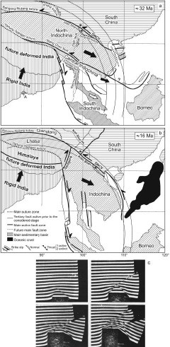
Look at the diagram below (source details at end of article):

The final panel shows photos from a plasticine analogue model as described above. The first two panels are a sequence, showing how material is extruded out from Tibet into South-east Asia. This extrusion process is also consistent with extension in Tibet. The crust is being compressed on a North-South axis but is simultaneously extending East-West.

An implication of this model is that these major faults are in effect mini-plate boundaries. For the model to work these faults need to cut the entire crust and to show major (1000 km) displacement. Therefore, one way of better understanding Tibet is to do a detailed investigation of a fault in Vietnam.

Searle et al. 2006 and Searle et al. 2010 tease out the detail of deformation and metamorphism around the Red River fault. This fault (near the label DNCV in the diagram above) is near metamorphic rocks and granites. Proponents of the extrusion model propose that these rocks were formed by syn-deformational shear heating along the fault, which is therefore a major crustal structure. Searle and friends refute this by detailed structural work and by deriving a Triassic age for metamorphism (which is before India hit Asia). They interpret this fault as a structure that cross-cuts older and unrelated rocks that are not caused by shear-heating.

In fact Searle and others have, for over 10 years, been arguing against the extrusion model, using various lines of evidence to show these large faults are not micro-plate boundaries.

Continuum dynamics – So, if the extrusion model doesn’t fit the evidence, how do we explain Tibet?

Another approach is to model the behaviour of Tibet using continuum dynamics. Put crudely, this takes the micro-plate idea to its logical conclusion. If you divide a rigid plate into smaller and smaller sections ad infinitum, what do you get? If every atom is free to move independently of the rest, you get something that behaves like a fluid.

Stop! Before you click away in disgust at my madness, consider the mantle. This convects, just like a fluid, does it not? Given enough time (and high enough  temperatures) rock will act like a fluid, just a very very viscous one. Rocks on the surface of Tibet are cold and brittle, they are cut by faults, but most of the volume of the crust is deeply buried and quite hot. Continuum dynamics is an approach that models the entire crust and regards brittle structures on the surface as more symptom than cause.

Continuum dynamical approaches to continental deformation identify two drivers: external ‘boundary forces’ (rigid India colliding) and internal ‘body forces’ caused by gradients in crustal thickness. If these balance out then an equilibrium is achieved, if they don’t, then crust will flow. In the face of continued Indian convergence (associated with a force pushing India north) the crust thickens and the Tibetan plateau is created.

Continuum dynamics is most closely associated (at least in my mind) with the work of Phil England of Oxford, but the key papers involve many other big names in Geology.

Summary and next steps – So, in summary, continents don’t behave like oceanic plates. Portions of them behave like rigid micro-plates, but in areas like Tibet the crust can behave like a fluid. By modelling modern day topography and crustal surface flow (which can be directly measured via GPS), the viscosity of Tibetan crust has been estimated to be only 10-100 times more than convecting upper mantle. Our mental picture of a fluid planetary interior and a rigid crust above is too simple: sometimes even the crust behaves like a fluid.

This post is the second step of a journey to explain my pictures of Mount Everest. What lies ahead? I feel I ought to have a go at doing more justice to rheology and crustal structure as I’ve barely struck it a glancing blow here. These concepts will help us approach different and perhaps better models of Himalayan geology. Also I’m bound to get distracted along the way by some pleasing diversion or other. Stick with me as the journey will be worth it. Why?- “because it’s there“.

Declaration of Interest. Mike Searle and Phil England taught me, plus many proponents of the extrusion model are French. I’ve tried to be even-handed, I have, but do be aware of the tribal loyalties and ancient anti-gallic prejudices that are bubbling around in my subconscious.

Further reading & references

This post owes a lot to Searle et al. 2011 (doi: 10.1144/​0016-76492010-139) which helped refresh my memory and bring my knowledge up to date. I shall be returning to it in future posts as I’ve only covered a small portion of it.

Pete Molnar’s Nature paper from 1988, Continental tectonics in the aftermath of plate tectonics is an early introduction of the distinction between continental tectonics and class plate tectonics.

Searle et al. 2006 (doi:10.1144/0016-76492005-144) and Searle et al. 2010 (doi: 10.1130/GES00580.1) are specific studies arguing against the extrusion model by looking at the Red River fault., The discussion arising from the 2006 paper gives a view from proponents of the extrusion model (doi:10.1144/0016-76492007-065).

Image credits

Images taken from Google Earth. Diagram taken from Searle et al. (2011) with implicit permission of the Geological Society of London and kind permission of Prof. Mike Searle.

A journey through the geology of mountains

This post is part of my journey into the geology of mountains.

I’ve got a picture of Mount Everest to show you. It is gorgeous. I’ve got a plan to rhapsodise for a good while about its Geology, too. I’m going to make you wait though, so I can be sure that you understand what I’m talking about, that you fully understand how the Geology of Everest is interesting and counter-intuitive. You’ll see it in the context of mountain belts across the world, old and young. What a glorious moment that will be!

In order to reach those giddy heights I need to do two things. First, write a series of posts detailing our geological understanding of mountains, secondly get you to read them. A huge challenge no doubt, but I at least will enjoy the journey. So, I’ve a mountain to climb, let’s get going!

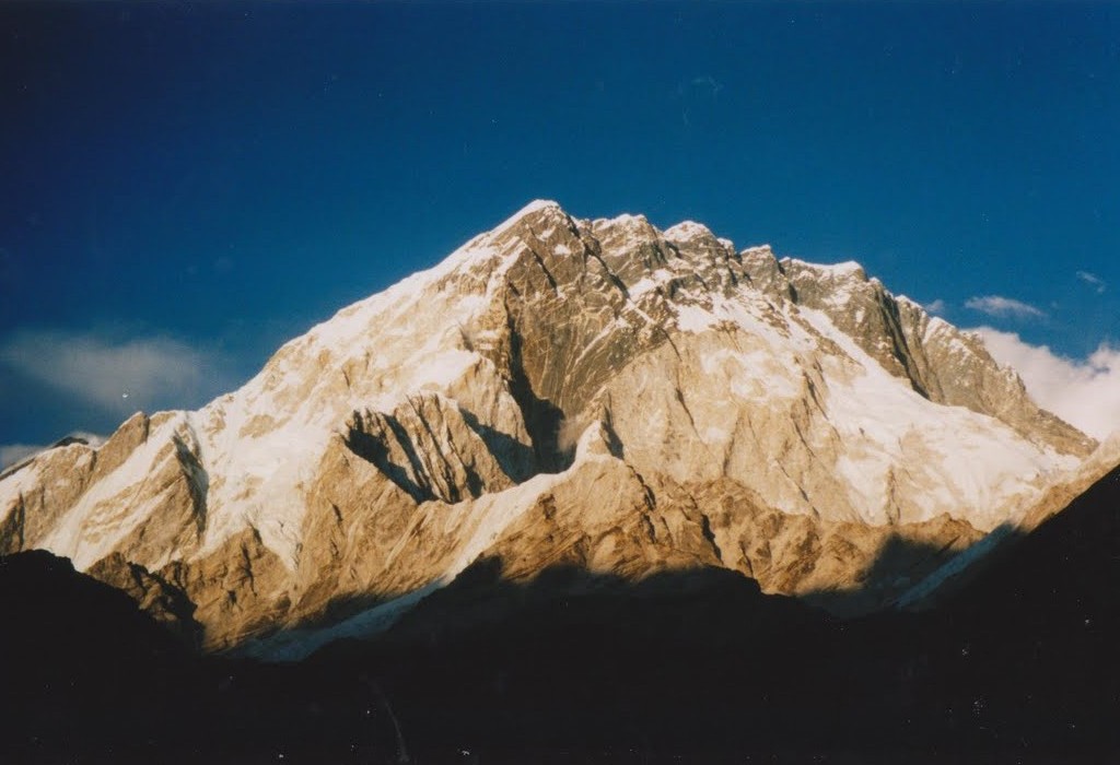
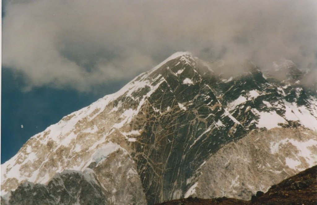
Mountains are rather obvious things, if you’ve been near any. They look like this:

South face of Nuptse, Nepal. Everest is hidden behind this.

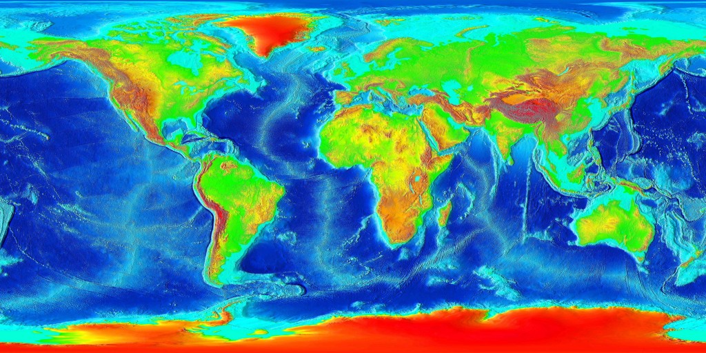
Big, pointy, covered in snow. A look at a topographic map of the world shows us where  modern mountains are to be found.

Look at the red areas which are high altitudes. Ignore Greenland and the Antarctic, they are high due to ice-caps, which is cheating. Ignore Southern Africa as that is a high plateau rather than mountainous. Otherwise, what do you see?

Firstly, an obvious chain of mountains all along the west side of the Americas. Next a line of red staring at Spain and Morocco moving east via the Alps, Iran into the Himalayas and Tibet. Extra marks if you spotted New Guinea. All of these areas are active mountain belts. Belts because of the shape, active because the plate tectonic forces that created them are still ongoing.

As with most things in Geology, an explanation of why mountains are formed starts with plate tectonics. Where a continental plate is involved in a collision, mountains are formed. The second plate might be oceanic (Pacific ocean hitting Americas = the Andes, Rockies) or continental (India/Africa hitting Eurasia = Alps/Himalayas). That’s the sentence-length explanation. Much more in later posts.

Oh, and we are not talking about volcanoes. A volcano is a big hilly thing and so is a mountain, but geologically it is totally different. Think about the volcanoes in the Andes. They are locally important but the reason the Andes stand out in the map above is not due to the volcanoes, they sit on top of the mountain belt.

There are those who say that the only sensible place to study how mountains form is in active mountain belts. Where you know the plate tectonic context (you can trace India’s progress north, for example) and you can use geophysical techniques to infer what is happening at depth. There are others (those with smaller fieldwork budgets perhaps) who say that studying ancient fossil mountain belts is also vital. Why restrict yourself to only the few active mountain belts? There are rocks that were formed in ancient mountain belts virtually everywhere.  When discussed these, geologists are apt to start using the term orogens or orogenic belts. These are basically fossil mountain belts. They contain rocks that are deformed and metamorphosed, recording the processes that caused a mountain belt to be formed. Across Geological time, there have been a lot of orogenies.

My favourite orogenic belt is the Appalachian-Caledonian, which sits either side of the North Atlantic. It stretches from the Appalachians via Ireland and Scotland into Norway and east Greenland. A note of caution here, the orogen is found in areas that are locally known as mountainous, but this is not due to mountain building processes directly. The Appalachian mountains are higher than their surroundings because they are more resistant to erosion, or due to effects relating to Atlantic opening (same for Scotland and Norway). Also, with all due respect, they are not real mountains. They only reach 2km in height whereas most of the Tibetan plateau is at 5km and Everest is nearly 9km. If large chunks don’t regularly fall off and you don’t get short of breath due to altitude at the top, its not a real mountain, no matter how pretty it is.

In the next step on our journey up towards the top of world, I’ll be talking about how the recognition that classic plate tectonics doesn’t work well with mountainous areas led to the complimentary concept of continental tectonics.

I’ll leave you with another view of Nuptse, to whet your appetite.

Topographic map of world courtesy of Wikicommons. All others are mine, for a change.