Andalucia: a history of stuff

Andalucia is a province in Spain, at the far south west of Europe. Its long and varied human history has seen it linked to the middle East, north Africa and the Americas. The creation of these links brought new foods, metals, diseases: new stuff into Andalucia. Sometimes the impact of arrival created ripples that reached out far across the world.

Geological history

Some 200 million years ago Andalucia was within a massive continent called Pangea, close to both Africa and North America. Slowly Pangea broke into pieces, a new ocean basin – the Atlantic – filling the gap as the Americas drifted away. Some 50 million years ago, Africa was pushed north in Europe creating a long mountain range. Andalucia was part of this. Mountains form when the crust is thickened, pushing rock into the sky. A similar process at the base of the lithosphere 1 also forms a thick balancing ‘root’. Under Andalucia, this thick root ‘fell off’2 and sank into the hot convecting mantle beneath.

Mountain belts are surprisingly fragile. The sudden removal of the heavy root caused the over-thickened crust to collapse, flowing sideways and bringing deeply buried rocks up to the surface3. Fragments of mantle called peridotite, not often seen at the surface, form brown mountains around the town of Ronda. The collapse of the mountain belt went so far that its centre is now the very western part of the Mediterranean, the Alboran Sea. The mountain became a great hole in the ground.

Most of Andalucia is made up of sedimentary or metamorphic rocks folded and twisted by these dramatic changes. An exception is the basin of the Guadalquivir river. Here the weight of the collapsing rocks pushed down the rocks to the north, making a depression that has filled with recent sediments – a feature called a foreland basin. The edge of this flat basin makes a clear line that is easily visible from satellite views of Southern Spain.

From Wikimedia http://upload.wikimedia.org/wikipedia/commons/5/53/Andalucia_satelite.jpg

Andalucia from Space. Image from Wikimedia 

People

People, at first hominins such as Neanderthals, have lived in Spain for over a million years. The little we know of prehistoric humans comes from their use of materials. First their gradually more sophisticated use of stone tools, then from about 5000 years ago the smelting of metals: first copper, then bronze (copper plus tin) and then iron. Mines in Andalucia have been been involved since the start, notably the Rio Tinto area. Here a Carboniferous massive sulphide deposit has yielded silver, gold and copper and spawned a global mining company.
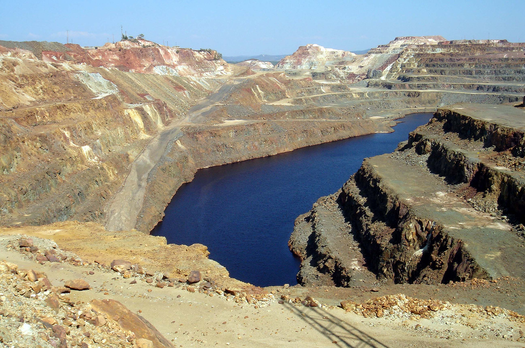
Image of Rio Tinto mines, Andalucia. Image from David Domingo on Flickr under CC

Rio Tinto mines, Andalucia. Image from David Domingo on Flickr under CC

Around 3000 years ago (1100BC) the Phoenicians reached Andalucia, founding the town of Cadiz. A culture that reached across the Mediterranean they were also involved in trade with the British Isles. Tin from Cornwall in England was smelted with Spanish copper and the resulting bronze traded on. The olive tree reached Spain at this time, brought from the eastern Mediterranean.

A mere thousand years later, the Romans took control – their province of Hispania Baetica covers much of modern-day Andalucia. They introduced deep mining to the Rio Tinto, using the characteristically Roman combination of slaves and very big wheels to pump water up from the depths. Andalucia was a renowned source of many products for the wider Roman Empire, including silver, olives, emperors, philosophers, dancing girls, and garum, a sauce formed from fermented fish guts rich in umami flavours.

Yet Moor invaders

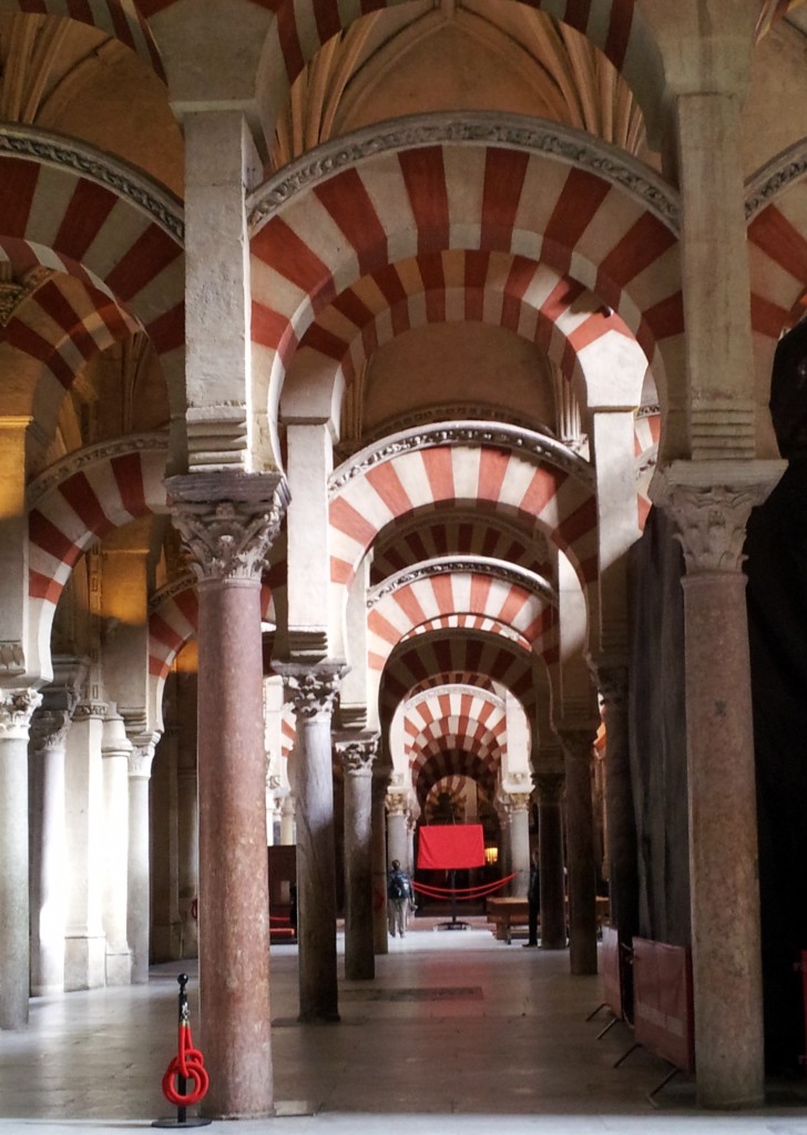
After the slow collapse of the Roman Empire, the next major influx of change in Andalucia was the Moorish invasions. The Islamic Moorish army4 conquered most of Spain between 711 and 718 AD, in time creating a kingdom of Al-Andalus with its capital in Cordoba. Once more Andalucia was part of a multi-national empire with good trade links. Valuable crops from further east, such as figs, citrus and pomegranate were introduced for the first time, as were sophisticated irrigation systems, some of which are still in use. By the 10th century, Cordoba was the most civilised city in Europe, it’s Grand Mosque was one of the wonders of the Muslim world.

Cordoba Grand Mosque

The site of the Grand Mosque was originally a Christian cathedral (before that, a Roman temple). Built over 200 years and funded in part by mining proceeds, the Mosque was built with local stone and brick, but also recycled Roman stone columns. Some of these were found locally, but others were brought in from much further afield, from the rest of Spain and perhaps wider.

The Columbian exchange

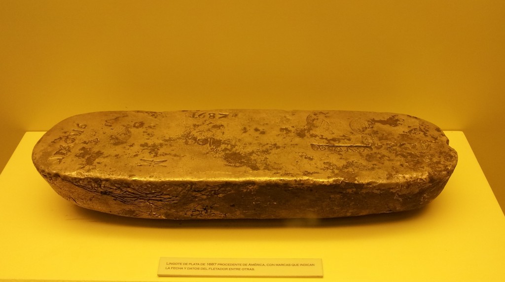
Eventually Moorish Spain came to an end as Christian rulers conquered the Muslim lands. The final Moorish kingdom of Granada fell to Ferdinand and Isabella in 1492, the same year that they sponsored Christopher Columbus to mount an exhibition across the Atlantic. As  the Spanish kingdoms turned into a global Spanish empire, lots of incredible things started flowing back into Andalucia. First Seville and later Cadiz were the main ports for the Atlantic trade. Gold and silver beyond imagining passed through Andalucia – enough to create a century of inflation across Europe. Some of this stuff ended up in the the Grand Mosque in Cordoba, which is now a cathedral again. Sitting within the vast pillared area of the mosque is a Christian church full of beautiful things made of American gold and silver. The choir stalls are made of American mahogany – lots of plant material crossed the Atlantic too.

Ingot of South American silver as brought over by Spanish treasure ships. Cadiz Museum.

Ingot of South American silver as brought over by Spanish treasure ships. Cadiz Museum.

A popular Spanish dish is called ‘patatas bravas’ and consists of potato, tomato and chili – all foodstuffs that spread across the world following the ‘discovery’ of the Americas. Andalucia was the first stop for many of these vegetable treasures. Botanical gardens turned seeds into plants, to be studied and propagated. A fine building in Seville is the old tobacco factory, dedicated to processing another new crop. The setting of Bizet’s opera Carmen, its walls are mottled with yellow and brown, like a smoker’s fingers. More immediately bad for the health, syphilis was first recognised in Europe in 1494, most likely brought back by Columbus’ sailors.

The British dimension

As an Englishman who likes history, I often visit other countries in an apologetic mood. A dimly remembered story about Francis Drake daringly ‘singeing the king of Spain’s beard’  is rather less jolly when you are sitting in Cadiz, the town that was attacked. Drake was engaged in warfare on behalf of his Queen, but also behaving like a pirate, raiding Spanish treasure ships. Still, no one seems to mind any more; it was in 1587 after all.

The British drink everything and anything. Not content with home-grown beer, gin and whisky we also crave grape-based booze. When Francis Drake returned from attacking Cadiz, he brought 2,900 barrels of sherry, a type of wine made only near Jerez in Andalucia. This went down rather well – we’ve been drinking it ever since, even getting involved in its manufacture.

Tonic water is sweet fizzy water flavoured with quinine, best taken with gin. Quinine, an extract from a South American tree was for centuries the only effective way of countering the effects of malaria. First popularised by Spaniards returning from Peru it was introduced to gin by the British in India. In the early 18th century the Royal Navy had a number of bases on Spanish soil, including in Andalucia, and passed the habit on. It remains popular in Spain to this day.
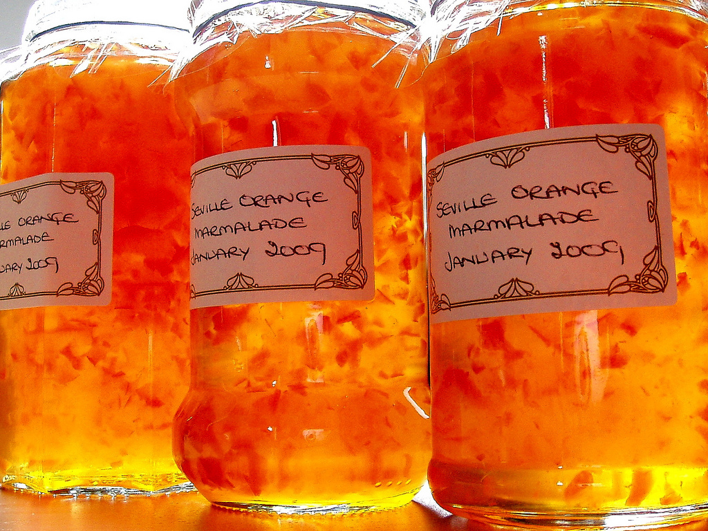
Image from Amanda Slater on Flickr under cc

Image from Amanda Slater on Flickr under cc

A final anglo-Spanish connection is marmalade. Seville is full of orange trees, of a particular kind, bitter and rich in pectin. They are pretty inedible raw, but for some reason 5A Scottish tradition and industry grew up of preserving them as jam, with pieces of the skin floating in jars of pungent and yielding orange delight. Paddington Bear, James Bond and Alice in Wonderland all eat marmalade, along with many real people, such as me. The bitterness gives it a very grown-up feel, with some of the grimy delight of cigarettes and whisky, but in a healthy breakfast-friendly form.

The future

What of the future? Recent research suggests that soon6The oceanic crust beneath the Atlantic will start to plunge down under Spain into the earth’s mantle. The collapse of the mountain belt I mentioned at the beginning left a tear in the crust and this may grow and extend into a full-blown subduction zone. This will bringing volcanoes to fertilise the soil with ash and earthquakes to shake the buildings (if any remain). As slowly as finger-nails grown the Atlantic will vanish and Spain and the Americas will be reunited once again.

Telling stories about Irish Geology

I clearly remember the most important moment of my geological career. I was resting my back on a glacially-polished wall of gabbro, my feet in an Irish bog, talking to myself in the sunshine. As a young man with bushy hair and beard, tattered field gear, wellington boots and a battered rucksack held together by darning and staples, I was recognisably a geologist, a ‘hammer-man’ in local parlance.

I was looking around as I talked to myself. This is a natural enough thing to do in beautiful Connemara. I’ve spent a lot of time admiring the interplay of sun and cloud and rain and glacial peaks there. I can especially recommend gazing out to sea, enjoying the sense of being at the end of the world, with the whole Atlantic before you. On a practical note, the west is where the showers come from; a glance that way gives you your own personal very-short-range weather forecast.

This time I was looking right at the low bobbles of the Dawros peninsula and left to the rounded hump of Currywongaun and Doughruagh’s majestic black stack. My gaze wasn’t aesthetic but geological, conceptual. In my mind these were no longer hills, but bodies of molten rock, injected into the beating heart of a mountain range millions of years ago.

I was talking because I was telling myself a story. A scientific story, where every detail is backed with evidence and armoured against the necessary pedantry of the scientific process. My story was a good one – good enough to turn into a scientific paper – I had not wasted the last 2 years of my life on pointless data collection after all. Best of all, my story felt like The Truth. I could dare to let myself believe that I understood events that happened miles underground millions of years ago. It was a good feeling.

The Dalradian in 1995

The modern consensus about the rocks of Connemara is that they are Dalradian sediments, deformed and metamorphosed over a short period of time by the Acadian/Grampian orogeny. Back in 1995 when I was a scruffy PhD student1 this was far from being a consensus. Some scholars (including, not incidentally, one of my supervisors John Dewey) were promoting the short orogeny model, but others disagreed. They had evidence on their side, too.

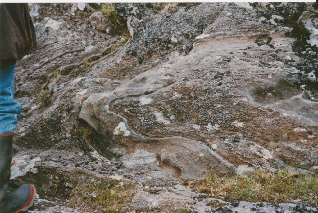
Understanding the timing events in deformed metamorphic rocks is helped by correlating phases of deformation and metamorphism. For Dalradian rocks there was a consensus that the ‘D2’ phase involved burial, heating and intense folding. D2 is associated with the original Barrovian style of metamorphism. Later, D3 involves less intense folding and in some areas Buchan style metamorphism linked to heating following the intrusion of gabbro intrusions into already hot rocks.

In the 80s and 90s, radiometric dating began to be applied to these problems. Direct dating of metamorphism was not then possible and the most reliable source of ages were zircons crystallised in igneous intrusions. Intrusions like the Ben Vuirich granite in Scotland – in 1989, Rogers et al. dated this as 590 million years old. Previous studies had interpreted the granite as being older than D2, but younger than D3. Scottish gabbros linked to D3  had been dated to around 490 million years, meaning that D2 and D3, far from being part of a single quick orogeny must represent, not a single quick orogeny, but entirely different mountain building events separated by 100 million years. In 1994, remapping of the Ben Vuirich granite showed that it was in fact pre-D2 (Tanner and Leslie, 1994), allowing advocates of the quick-Taconic model to argue it was pre-orogenic and therefore not relevant to these debates.

This was going on slightly before and during my PhD research. The challenge of linking igneous intrusions to deformation sequences was core to my work.

ss

D3 folds of a D2 fabric. Sillimanite blebs aligned axial to the D3 folds. Connemara. Wellington boots for scale courtesy of the Geological Survey of Ireland

The Geology of Connemara in 1995

The rocks of Connemara correlate with Scottish events. There are extensive gabbro and calc-alkaline intrusions associated with an intense D3 phase of metamorphism. Most of these intrusions are in the south and the pattern of metamorphism reflects this, with sillimanite grade metamorphism close to them and lower temperatures further north.

These gabbros were originally correlated with D2 deformation, but in 1990 Geoff Tanner, partly in response to the Ben Vuirich date, argued that they were post-D2 and pre-D3.

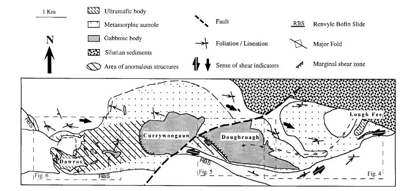
For my PhD, I focused on a set of gabbro intrusions in the north of Connemara known as the Dawros-Currywonguan-Doughruagh2-Complex (DCDC). I produced detailed maps of the structures in these deformed rocks, focussing particularly on fabrics and shear-sense. I also did a lot of metamorphic petrology, describing the large metamorphic aureole around the intrusions. After a few years of this, I had enough data to start putting my story together.

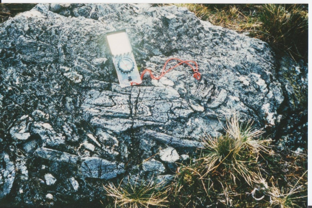
The Currywongaun contains xenoliths of partially melted granulite facies sedimentary rock. Within these xenoliths are fragments of folded rocks, suggesting that had been deformed before the gabbro was intruded. The gabbro was intruded into rocks that were already at amphibolite grade (550 °C). There is abundant evidence that the magma was affected by deformation during its intrusion – it is syntectonic. Small intrusions within the DCDC are deformed by a fabric that is the same as the D2 fabric in the sedimentary rocks surrounding it. Overall, this evidence points to a syn-D2 page for the intrusion of the gabbros.

Ff

Folded fabric in a block of quartzite within a gabbro intrusion. The whole area is a xenolith, fractured by partial melting

There’s more. The larger gabbro bodies are extensively hydrated. Gabbro intrusions start off relatively dry, but if they are intruded into already hot metamorphic rocks they drive even more metamorphic reactions that produce water. As the gabbro cools a little (down from an initial 1200 °C) the water surrounding it makes its way into the intrusion. This water metamorphoses the gabbro into wet amphibolite, which is weaker than the gabbro and so is preferentially deformed. The west edge of Currywonguan is the site of a fantastic shear-zone that was active at high temperatures. In the country rocks, these fabrics cross-cut granulite facies D2 fabrics and can be correlated with D3 folding.

So the gabbros were intruded during D2, but affected by D3 folding while still hotter than the surrounding rocks. A spot of primitive (but effective) thermal modelling allowed me to show that the pulse of heat associated with these relatively small intrusions would have vanished within half a million years. So  D2 and D3 were close in time – consistent with the ‘quick-Taconic’ model.

figure 3 wellings

A sketch map of the Dawros-Currywongaun-Doughruagh intrusion from my paper.

 Academic hurly-burly

Every good story needs a bit of conflict. For my story, it came from the radiometric dates. A 1988 paper dated the Connemara gabbros at 490Ma. Whereas 1993 and 1996 papers gave dates of around 470Ma for the D3 metamorphism.  This gap of 20 million years doesn’t fit my story.

At this point, you may well be thinking that I must be wrong. Hard science, numerical analysis of isotopes must surely trump my hand-wavy field-based studies? No. Remember the paper was from 1988. Back then people still thought digital watches were a pretty neat idea. They dated zircons, not with high-precision laser beams but by chucking a bunch of them into acid. They didn’t even abrade them first. The date was based on the assumption that there was no inherited lead in them. I had no doubt that the date was wrong and I said so in public, at conferences and eventually in an academic paper.

Not everyone agreed. At a conference, after a talk I was told by a angry geochronologist that I couldn’t expect to be taken seriously if I went around saying radiometric dates were wrong. He hadn’t produced the date I disagreed with, but he clearly took it personally. This incident, the venom with which he disagreed with me, marked the start of the end of my geological career.

Closure

Some scientific disagreements remain unresolved for years. Not this one.

Anke Friedrich, a German PhD student at MIT started working on Connemara a few years after me. Soon after I’d been told off for doubting a published radiometric age, she proved it was wrong by redating the same rocks. The whole suite of dates she produced was powerful evidence for the ‘quick-Taconic’ model. All of the magmatism in Connemara and therefore the associated metamorphism and deformation lasted only 12 million years.

I was pleased to be proved right, of course, but I don’t actually remember when I first heard about it. I was so certain that I had to be correct that my reaction would have been quite mild. In this, I wasn’t unusual – I am far from the only scientist to have been hugely certain that they are correct. What strikes me now is how far away this is from the way science is ‘supposed’ to work. How can this be?

Leaning against my syn-tectonic gabbro, feeling I knew The Truth felt great. It helped motivate me: I’m only human. When I was ‘doing science’, writing papers, this feeling was irrelevant to the process of presenting evidence and suggesting hypotheses. Further, Anke Friedrich’s paper is rightly much more highly cited than mine. Her range of radiometric dates is the best scientific evidence for the ‘quick-Taconic’ model within Ireland. ‘Science’ is bigger than what goes on in scientists’ heads – its a process, not just a bunch of people’s opinions.

References

ROGERS, G., DEMPSTER, T., BLUCK, B., & TANNER, P. (1989). A high precision U-Pb age for the Ben Vuirich granite: implications for the evolution of the Scottish Dalradian Supergroup Journal of the Geological Society, 146 (5), 789-798 DOI: 10.1144/gsjgs.146.5.0789
TANNER, P., & LESLIE, A. (1994). A pre-D2 age for the 590 Ma Ben Vuirich Granite in the Dalradian of Scotland Journal of the Geological Society, 151 (2), 209-212 DOI: 10.1144/gsjgs.151.2.0209
WELLINGS, S. (1998). Timing of deformation associated with the syn-tectonic Dawros Currywongaun Doughruagh Complex, NW Connemara, western Ireland Journal of the Geological Society, 155 (1), 25-37 DOI: 10.1144/gsjgs.155.1.0025
Friedrich, A., Bowring, S., Martin, M., & Hodges, K. (1999). Short-lived continental magmatic arc at Connemara, western Irish Caledonides: Implications for the age of the Grampian orogeny Geology, 27 (1) DOI: 10.1130/0091-7613(1999)​027​2.3.CO;2

The Grampian / Taconic orogeny in Ireland – when arcs attack

Ever since the plate tectonic paradigm-shift of the 1960s, geologists have strived to understand ancient rocks in terms of the movements of plates. The geology of north-western Ireland can be explained by what happened when a subduction zone ran out of oceanic crust back in the Ordovician. Let me take you back to before that happened.

Imagine you are floating in the sea. In 480 million years time the crust below will be in Ireland. The sea is warm – CO2 levels are high and you are fewer than 30° south of the equator. Apart from cheeky trilobites nibbling your toes, it is an idyllic place to be. You are near a large land-mass. It’s barren looking  – plants are just about to learn how to survive outside the sea 1 so there is little to soften the landscape. The tumbler of gin and tonic2 you clumsily dropped has sunk into sediment that will one day be part of the Dalradian Supergroup.

Your mood has soured. Not only has your drink gone, but you’re getting creeped out by the cloud on the horizon out to sea. It’s not a fluffy, friendly one but a dark spreading plume of volcanic ash. Far out to sea, there is a line of volcanoes and they spell D-O-O-M for the peaceful spot you’ve found. Every year the volcanic arc gets a little bit nearer. Eventually it will smash into the continent behind you, grinding over the top. The peaceful sand and mud washing around below your feet will be sediment no more. The collision between the volcanic arc and the continent will transform the Dalradian sediments into the contorted metamorphic rocks that today make up much of NW Ireland.

An accident waiting to happen

Here’s a diagram showing a section through the land below. Black is oceanic crust, yellow stippled is sediment3.

x-section 1 geo labels

Let’s start from the left. Notice that the edge of the continent is thin and tapering – it was stretched out when the ocean basin formed. The oceanic crust attached to the continent is being stuffed down back into the deep earth. As it sinks, it is squashed and heated, starting a complex process that ends with molten rock reaching the surface. Over time this magma has formed a volcanic arc, a small piece of thickened crust.

This situation can’t last for ever. Once all of the oceanic crust of the lower plate has run out, normal subduction comes to an end. The upper plate slides over the thinned continental margin and ends up lying on top of the continent – a process called obduction. The island arc and forearc basin are squashed against the continent. Like a bulldozer hitting a pile of sand, the arc collision compresses and thickens the crust. The Dalradian sediments become thoroughly deformed and heated and are now a wildly complex set of schists and marbles.  This process creates a mountain belt, an event known as the Grampian orogeny.

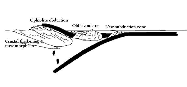
As shown in the diagram below 4, the orogeny does not stop plate convergence. The old subduction zone has been destroyed, but another one is created in the opposite direction. This process, called ‘subduction flip’ changed the tectonic stress regime; it’s believed to have led to a process of ‘orogenic collapse’ whereby the thickened crust extends and thins, bringing metamorphism to an end. The overall tectonic event was remarkably quick, around 15 million years.

x-section 2 base

Where are they now?

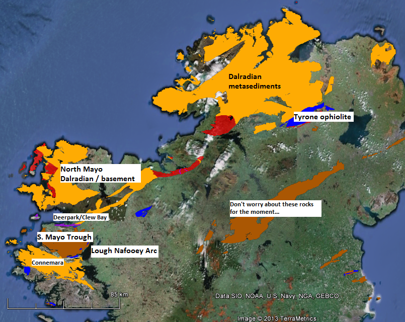
This type of orogeny can be recognised as it leaves distinctive rock types behind. Ophiolites, pieces of oceanic crust within continents are found in several places in Ireland; the largest example is the Tyrone ophiolite, but traces of oceanic crust can also be found in Mayo, near Westport, in the Clew Bay and Deerpark Complexes. The story goes that there are no snakes in Ireland because Saint Patrick, while fasting on top of Croagh Patrick, threw them down into Clew Bay. That the sea-facing side of the mountain contains a lot of green serpentinite suggests the origins of the story have a geological angle5.

ireland grampian map

Map of NW Ireland. Red – continental basement, Yellow-Dalradian, Blue – lower-mid Ordovician volcanics, Brown – Ordovician sediments, purple serpentinite & melange. Data from Geological Survey of Ireland, displayed using Google Earth

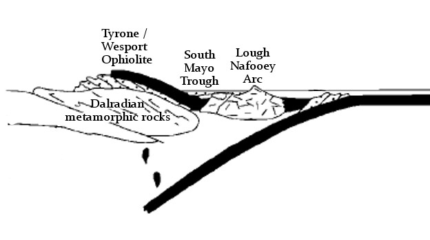
Parts of the volcanic arc can now be found around Lough Nafooey, just to the south of the South Mayo trough, which corresponds to the fore-arc basin. The Dalradian sediments and underlying older crust make up most of the land to the north west of these rocks.
Let’s revisit the cross-sections, labelling the modern day equivalents. Before the collision:

x-section 1 geograph labels

and immediately afterwards:

cross section of Grampian orogeny

A wider context

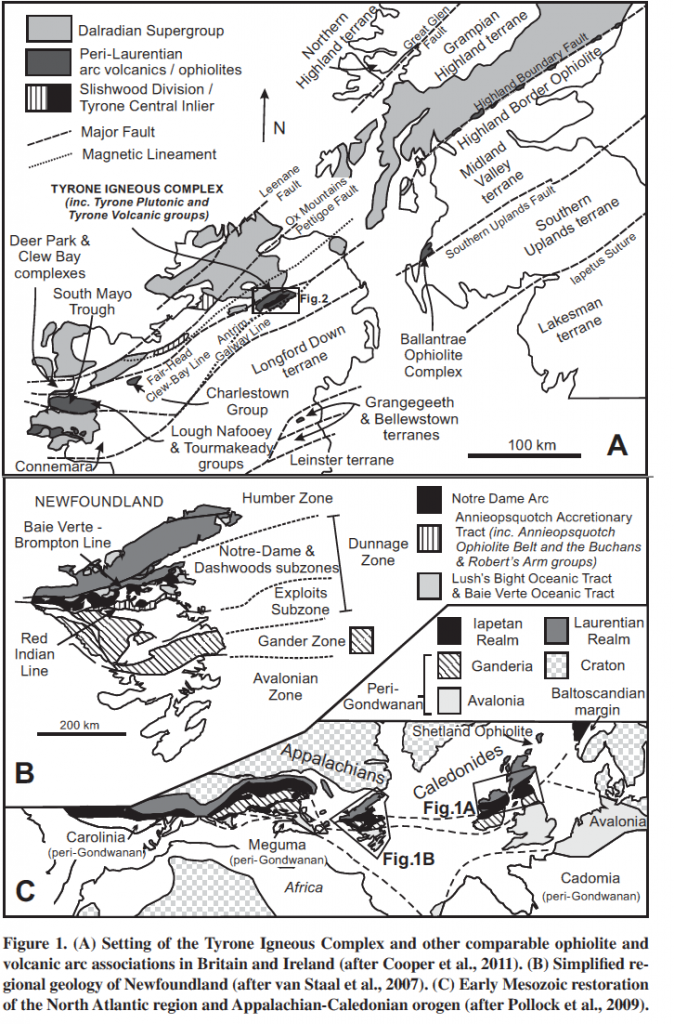
Ireland was only a small section of a continental margin that stretched from rocks now in Greenland down into the eastern US and Canada. The Grampian orogeny also affected Scotland and the same arc-collision event is found in eastern Northern America where it is known as the Taconic orogeny. 

Figure 1 from Hollis et al. 2012

Figure 1 from Hollis et al. 2012

Recognising the connection across the Atlantic helped geologists understand the causes of these complicated patterns in the rocks – different sections show different parts of the orogeny and synthesising research across a wider area leads to a richer understanding. The patterns are complex – more so than I’ve shown above. There were probably multiple ‘accretion events’ where different arcs collided at different times. The pattern of plates in modern day SE Asia is seen as an analogy here – they may have been multiple subduction zones and arcs within the wider ocean.

Geological is 4-dimensional, and the Grampian/Taconic orogeny reminds us of this. The timing of the various accretion events varies because the edge of the continent was not straight. Promontories (sticky-out bits) were hit by the arc sooner than parts where there was more oceanic crust to be consumed. Another complication is that continents don’t break cleanly: fragments of continental crust can end up far from the main continent (for example Rockall in the Atlantic). The arc whose collision caused the Grampian orogeny in Scotland (now found buried in the Midland Valley) is thought to sit on continental crust.

These 15 million years were a very important time for the crust of the northern half of Ireland, but are only a small part of the wider geological history of Ireland. I’ll leave the story unfinished here and tell you what happened when the new subduction zone ran out of oceanic crust in future posts.

References

RYAN, P., & DEWEY, J. (1991). A geological and tectonic cross-section of the Caledonides of western Ireland Journal of the Geological Society, 148 (1), 173-180 DOI: 10.1144/gsjgs.148.1.0173
Hollis, S., Roberts, S., Cooper, M., Earls, G., Herrington, R., Condon, D., Cooper, M., Archibald, S., & Piercey, S. (2012). Episodic arc-ophiolite emplacement and the growth of continental margins: Late accretion in the Northern Irish sector of the Grampian-Taconic orogeny Geological Society of America Bulletin, 124 (11-12), 1702-1723 DOI: 10.1130/B30619.1
Bird, A., Thirlwall, M., Strachan, R., & Manning, C. (2013). Lu-Hf and Sm-Nd dating of metamorphic garnet: evidence for multiple accretion events during the Caledonian orogeny in Scotland Journal of the Geological Society, 170 (2), 301-317 DOI: 10.1144/jgs2012-083

Scandinavian crust now in Alaska!

The face of the earth is ever changing. Plate tectonics is slowly but surely rearranging the locations and inter-connections of continents. However knowing this in the abstract doesn’t prepare you for the awed surprise of discovering that a section of crust formed in Scandinavia is now found in Alaska.

The evidence for this comes from a massive accretion of data from geologists across the world. Build up a geological history, underpinned by accurate dating, for enough parts of the world and you can start correlating ancient events. Other tools area palaeomagnetic studies that can tell the you the latitude of a piece of crust at a given time and suites of fossils that trace small areas where organisms with local characteristics were found.

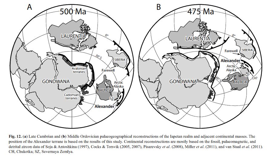
The latest research (Beranek et al. 2013) uses most of these techniques to nail down the link between a portion of Alaska and rocks now in Northern Scandinavia. It’s long been known that Alaska and Pacific Canada is made up of portions of crust (terranes) that formed elsewhere. The portion in question, the Alexander terrane is not small, covering 100000 km2 from British Columbia up into Alaska. Here’s where they reckon this crust was half a billion years ago:

Figure 12 from Beranek et al. 2013

Figure 12 from Beranek et al. 2013

The area labelled Laurentia corresponds to North America today, Baltica to Scandinavia. Arctic Alaska and Farewell are other terranes now found a long way from home. If you’ve read my post about rotating continents, you’ll have spotted the way Baltica dramatically swings round.

How did these terranes get round to the other side of Laurentia/North America?

Figure 11 from Colpron & Nelson 2009.

Figure 11 from Colpron & Nelson 2011. AX = Alexander terrane

This figure from Colpron & Nelson (2009) shows how. We are 50 million years further on from above. Baltica and Laurentia are now fused together, the ‘Caledonides’ – a strip of fascinatingly deformed rocks – mark where they collided. The  narrow subduction zone to the north of this area will over time pull itself forward, dragging the continental fragments over the top of Laurentia. A similar process is going on today in the Caribbean, where the Caribbean Arc is moving east, pulling ‘Pacific’ rocks further towards the Atlantic Ocean.

Ultimately these fragments end up plastered onto western Northern America in the area known as the Cordillera, waiting for cunning geologists to spot their true origins. I don’t know about you, but my flabber is well and truly gasted by this, by both the fact that it happened and that we can work out that it did so.

Colpron, M., & Nelson, J. (2009). A Palaeozoic Northwest Passage: incursion of Caledonian, Baltican and Siberian terranes into eastern Panthalassa, and the early evolution of the North American Cordillera Geological Society, London, Special Publications, 318 (1), 273-307 DOI: 10.1144/SP318.10
Beranek, L., van Staal, C., McClelland, W., Israel, S., & Mihalynuk, M. (2013). Baltican crustal provenance for Cambrian-Ordovician sandstones of the Alexander terrane, North American Cordillera: evidence from detrital zircon U-Pb geochronology and Hf isotope geochemistry Journal of the Geological Society, 170 (1), 7-18 DOI: 10.1144/jgs2012-028