Dalradian – a Celtic Supergroup

Geology is such a great thing to study because it involves making so many connections through time and space, switching scales from the cosmic to the atomic. This means that challenge for this series of posts about the geology of the west of Ireland is going to be managing scope. So. Although I could start with the big bang, I won’t. I’ll start with the Dalradian.

A thick package of sediment, the Dalradian Supergroup, or just Dalradian, to its friends was  was named in the 19th century after Dál Riata a minor kingdom in 6th and 7th century Scotland. Dál Riata was an Irish colony within Scotland, appropriately, as Dalradian rocks are found over much of Highland Scotland and NW Ireland.

A Celtic Supergroup

To fans of 1970s Prog Rock, a supergroup is a band formed from musicians who made their names in other bands. For geologists, it means a bunch of groups that are bound together, a group being a large recognisable package of sediment. The groups usually sit on top of each and represent a period of time during which sediment was deposited. For both types of supergroup, the individual members often have distinctive personalities.

The Dalradian Supergroup is made up of the Grampian, Appin, Argyll and Southern Highland groups.

The Grampian is the solid foundation of the Dalradian, fairly calm and ordinary: the bass guitar player of the supergroup. It is a 7-8 kilometre thickness of sandstones and muddy sandstones*. In Ireland, Grampian Group sediments are found only in North Mayo.

The Appin is the lead singer: shallow, good looking and gets lots of attention. Its made up of sandstones, limestones and more muddy sediments all deposited on a marine shelf in shallow water. Now somewhat changed, it contains some gorgeous rocks.
Glencoe Quartzite, Appin Group

Glencoe Quartzite, Appin Group

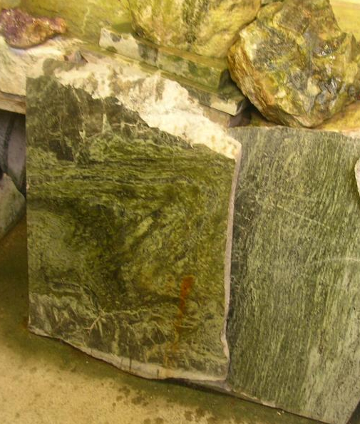
Picture of Connemara marble from

Famous ‘Connemara marble’ which is from, er, Connemara in Ireland. Picture credit.

The Appin group is found in the heart of Connemara, also across Mayo and Donegal.

The Argyll is the lead guitar. It’s deeper than the Appin and has been through some pretty intense times – brushes with death in fact. It contains the familiar sandstones and muddier sediments, but also more exotic sediment types.

Twice in the Irish Dalradian there occurs an odd pattern of rock-types. First there is a layer of sediment filled with angular fragments with a wide range of  sizes, called a diamictite. A number of subtle features show that it is sediment left behind by a glacier – it is a tillite. Immediately above is a layer of carbonate, a limestone or a dolomite. Such rocks usually form in nice warm parts of the earth so the association with glacial deposits is odd. The first of these tillilte-carbonate pairs can be traced across the Dalradian, indeed across the world. These are ‘snowball earth’ deposits. Some believe that at this time the entire earth was covered in ice, with glacial deposits forming near the equator. The overlying ‘cap carbonates’,  contain unusual carbon isotope compositions suggesting to some that life on earth nearly died at this time. This happened not just once, but twice in the Argyll.**
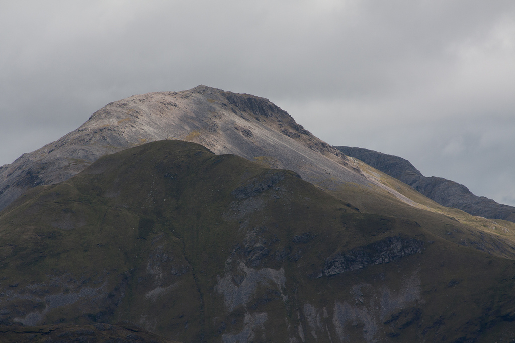
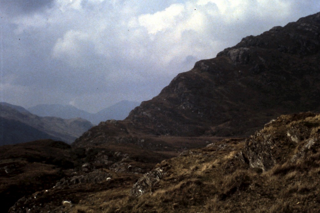
Picture of Argyll group sediments making up the Twelve bens mountains of Connemara. Image from Guilhem Boyer

Picture of Argyll group sediments making up the Twelve bens mountains of Connemara. Image from Guilhem Boyer on Flickr under Creative Commons.

The Argyll is rounded off with molten lava spilling into the sedimentary basin. Dangerous to be around for sure, but the Argyll makes the supergroup as a whole much more interesting and ‘edgy’.

The Southern Highland group is the drummer: completely crazy. The ground’s falling away under your feet, with sediments pouring into deep water and there’s another snowball earth episode***, there are big lumps of serpentinite, plus molten lava keeps coming out of the ground: madness. There’s a problem with ‘groupies’ as well. Lots of areas of sediment that say they’re ‘with the band’ but no-one is quite sure. Some of these, rocks along the Highland Boundary fault in Scotland or in Clew Bay in Ireland are worryingly young as well – Cambrian or even Ordovician. They’ve caused a lot of arguments, as you can imagine.

Song about a break-up

The Dalradian sing sad songs, about break-up: continents who once ‘were as one’ but who gradually drifted apart. It was a ménage à trois, so it was bound to end badly.

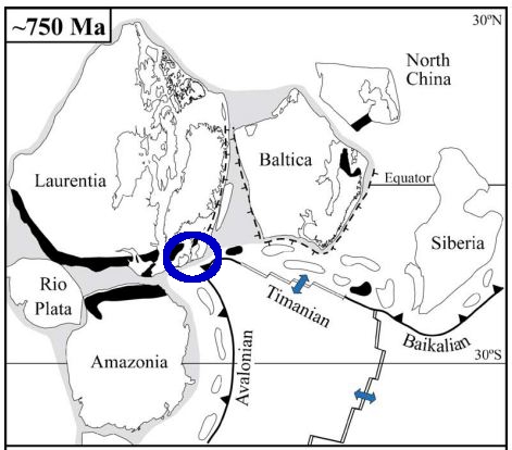
The song starts with the continent of Rodinia about 730 million years ago. This already had a rich and complex geological history which led to the creation of a large supercontinent consisting of pieces that now make up Scandinavia (Baltica), North American and NW Ireland and Scotland (Laurentia) plus Amazonia. Of course at the time these distinctions didn’t exist – it was simply a large single continent.

Rodinia 750 million years ago. From Cocks & Torsvik 2005

Rodinia 750 million years ago. From Cocks & Torsvik 2005

Cracks were starting to show, however. The Grampian Group formed in a rift basin, where Rodinia was starting to break-up. Early variations in the thickness of sedimentary layers suggest that faults were active during deposition. Times when the sedimentary basin became dramatically deeper also suggest tectonic involvement – active rifting was stretching the basin. There wasn’t a full break-up, however. Rifting ceased and a 30 to 40 million year period of calm saw the Appin group deposited in shallow waters under stable conditions.

The Argyll group saw rifting start-up again. By the end of the Argyll (600 million years ago) it became clear the split was going to be permanent. The stretching of the crust allowed the underlying mantle to melt, producing a ‘bimodal magmatic event’ with the intrusion of granites and the eruption of basaltic lavas. By Southern Highland group times, the sediments were forming in really deep water. Large bodies of serpentinite found in Ireland suggest the crust was stretched so much that material squeezed out from the underlying lithosphere.

This final extreme stretching marks the opening of a new ocean, called Iapetus. The opening of Iapetus created sedimentary basins all along the Laurentian margin. The Fleur de Lys Supergroup in Newfoundland and the Eleonore Bay Supergroup in Greenland were deposited in adjacent, equivalent basins. Further south in the US Appalachian belt, sedimentation associated with the opening of Iapetus starts only in Cambrian times.

Sing something simple?

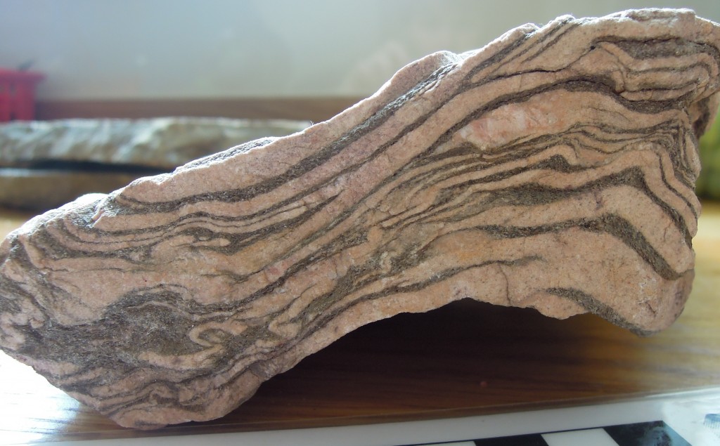
I’ve told a nice simple tale, based on current scientific consensus, but it used to be much more complicated. The problem is that these are no longer sediments. Key concepts in both metamorphic and structural geology were developed on these contorted, baked and squashed rocks. Seemingly simple things like identifying the base of the Dalradian is extremely difficult as the rocks below are often also metamorphosed sediments, first transformed before the Dalradian and then deformed and heated again alongside it. Drawing a line between two types of schist requires extremely careful analysis.

The Dalradian is intruded by many granites. Most are older than the deformation, but some are younger, intruded into deep sediments in the Dalradian basin while sediment was still settling on the surface above. A date of 590Ma for one of these ‘Older Granites’ caused years of academic chaos in the 1990s as the granite was initially (incorrectly) thought to post-date the deformation, meaning that any younger sediments couldn’t belong to the Dalradian.

Geological histories hinge on tiny facts. The age of single zircon grain, a fabric wrapping an andalusite crystal: great geological narratives are built from or destroyed by such tiny pieces of evidence.

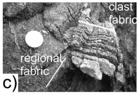
Evidence of mountain building episode during the Dalradian. From Hutton & Alsop 2004 GSL.

Evidence of mountain building episode during the Dalradian. From Hutton & Alsop 2004 GSL.

There is one inconvenient fact that might bring the whole of the simple story crashing to the ground. Respected researchers working in Donegal (Donny Hutton and Ian Alsop) have mapped an unconformity within the Argyll group. This could be consistent with our story – unconformities can form within sedimentary basins – but they interpret it as an orogenic unconformity. Based on various lines of evidence, including a tectonic fabric within sedimentary clasts above the unconformity, they infer a entire episode of mountain building took place during the gap in sedimentation shown by the unconformity. 

So is the Dalradian a single package of sediments formed during the opening of an ocean, or two packages separated by a previously unrecognised period of mountain building? I’ve no idea, but hopefully time will tell.

Regardless, everyone agrees on what happened next. Iapetus no longer exists: it opened and then it closed, moving the Dalradian from a sedimentary basin into the core of a mountain belt. That’s where we’re going next.

——————————————————————————————————————-

*they’re not sandstones any more, but we’ll come to that

** the first, the “Port Askaig Tillite” is correlated with the Sturtian global event at c. 700Ma. The second ‘Stralinchy diamictite’ with the Marinoan at c. 635Ma

*** the Inishowen and Loch na Cille beds are correlated with the Gaskiers global event at c. 580Ma

 References

L. Robin M. Cocks, & Trond H. Torsvik (2005). Baltica from the late Precambrian to mid-Palaeozoic times: The gain and loss of a terrane’s identity Earth-Science Reviews DOI: 10.1016/j.earscirev.2005.04.001

D.H.W. Hutton, & G.I. Alsop (2004). Dalradian Supergroup of NW Ireland
Evidence for a major Neoproterozoic orogenic unconformity within the Dalradian Supergroup of NW Ireland Journal of the Geological Society DOI: 10.1144/0016-764903-094

David Stephenson, John R. Mendum, Douglas J. Fettes, & A. Graham Leslie (2013). The Dalradian rocks of Scotland: an introduction Proceedings of the Geologists’ Association DOI: 10.1016/j.pgeola.2012.06.002

The west of Ireland: a geological journey

The west of Ireland is a special place. During the Celtic Revival, a literary and political movement spanning the 19th and 20th Centuries, it was seen by many as the ‘true’ Ireland. Haunted by the ghosts of the Irish potato famine, it’s gaelic-speaking communities were taken as a template for a future country freed from English interference. W. B. Yeats, poet and follower of magick, sought inspiration here. Other great figures of world literature, James Joyce and Oscar Wilde were influenced by the Celtic Revival, even if only as something to react against. Today, the remarkable nature writer and artist Tim Robinson lives and works in the ‘the West’, creating fabulous prose from his desire to know everything about tiny pieces of the land.

This is not a post about about Irish literature or history, much as I would love to write about the fascinating way they intersect and interweave. But these are deep waters, full of traps for the unwary Englishman and the amateur alike. But writing about the geology of the west of Ireland is something I’ve been trained to do.

moody Connemara rocks

The west of Ireland is dominated by the Atlantic. If you live there you learn to look towards the Ocean to see how soon the next shower is coming. Places like Achill Island feel like the prow of a battleship in stormy weather. Massive cliffs are moderated only by beaches covered in car-sized stones, shingled by the storms. On a typically brisk day, a car parked a mile inland becomes covered in sea-spray.

I have a big geological map of North America (you may have it too). Stretching over to include Iceland and Greenland, the eastern edge cuts only a tiny area of Europe – fragments of the west of Ireland seemingly adrift in the Atlantic ocean. It turns out that the Atlantic connection is more than poetic. For the best bits of its geological history, the north west of Ireland was part of the continent of Laurentia, now mostly found on the other side of the Ocean. The geological narrative I will be telling was hard-won – the big picture takes in Greenland, Scandinavia, Scotland, and the eastern USA and Canada. The west of Ireland is the keystone, joining different spans of knowledge together, holding up a great scientific structure.

Just as Irish writers created work with world-wide impact, so Irish geology has a wider role to play. How do we link the structures in ancient mountain belts to broad plate tectonic concepts? How long do orogenies last? How does magmatism affect metamorphism? How do we gain tectonic insights from sedimentary basins? The west of Ireland has much light to shed on all of these questions.

I will be writing a series of posts on the geology of the west of Ireland. I shall focus mostly on South Mayo and Connemara, but will take occasional trips elsewhere. This follows the pattern of the time I spent in Ireland, studying for my PhD. I’ll draw on this experience to give some insight into how science is really done. At times I’ll sound like I have all the answers, but I’ll also make it clear that really nobody does – science is always a work in progress. I’ll talk of the mistaken ideas of the past, plus the awkward facts that may ultimately overturn parts of today’s scientific consensus. Scientists are human too. I have a tale to tell of graduate-student-doubt, academic bitchiness and ultimate redemption at the hands of U-Pb geochronology.

The great comedy ‘Father Ted’ is another cultural product of the west of Ireland. So as Mrs Doyle would say “will you be having some more Irish geology blog posts? Ah go on. Go on now. Go on, go on, go on, go on, go on, go on, go on, go on…”.

Tim Robinson: Geology and place

Aran north

Tim Robinson is a celebrated author and visual artist whose intense engagement with the land beneath his feet is an inspiration to anyone who spends time in wild places. His work is inspired by the idea of ‘the good step’, of reintegrating body and world and achieving a state of consciousness ‘worthy of the ground we walk on’. The maps and books inspired by these abstract ideas contain enormous amounts of very specific information on the geology, archaeology, history, botany, language and folk lore of the West of Ireland.

I first encountered his work in my PhD field area in Connemara. One of the gabbro intrusions I was studying formed a hill called Doughraugh and I wasn’t sure how to pronounce it – the English language being absurdly inconsistent about the pronunciation of ough, as proved by the English towns of Slough (rhymes with cow) and Loughborough (‘luffburra’). I was pointed to Tim Robinson’s beautiful map and gazetteer of Connemara. Along with the location of fairy wells, infant burial grounds and much else, the map shows the placenames in their original Gaelic. Doughraugh, I learnt is a mangling of the Gaelic Duchruach or ‘black stack’ (the ‘ch’ sound is soft as in Scottish ‘loch’ and German ‘ich’).

A black stack (and a castle)

The map improves on the bad job done by an English-speaking cartographer working for the British Ordnance Survey in the Nineteenth century. It uncovers the pleasing fact that the name of the hill reflects the colour of the gabbro that forms it. This is what his work does, again and again and again, his fierce dedication to find out everything about a place creates dizzying connections between forms of knowledge often treated separately. Here the simple fact of a name of a hill is used to spin links between folk memory, past cultural imperialism and the unreflective nature of pyroxene.

When I worked in Connemara I didn’t understand this. It was a time when there were regular terrorist attacks in my country, and the people doing it used the Gaelic language as a badge of difference. Stupidly and wrongly I assumed Tim Robinson was some form of Irish nationalist and looked no further. Consequently I didn’t discover his books until later, when nostalgia for fieldwork and Ireland drew me to them. My love for his work is linked with my personal connection with the places he talks about, no doubt, but you should read them too, even if the closest to Ireland you’ve been is the bottom of a pint of Guinness.

Only a small proportion of his work deals with Geology directly, but he does so accurately and poetically, acknowledging how he draws on his interactions with local experts. Most interestingly, he comes at Geology from the perspective of an artist. For example he writes beautifully of Deep Time, of the awe that contemplating the age of rocks should generate in any thinking person. There is a beautiful section in Stones of Aran: Pilgrimage where he talks about a glacial erratic, covering myth (saints sailing on the stone across the sea) and Geology together. He’s read the scientific papers about the the rock and talks of one exhibiting ‘one of the most lapidary prose styles I’ve ever come across’. He then quotes a chunk of the technical language verbatim and talks about how he, a non-specialist, relates to it – a lovely new perspective on scientific language. Note also the ‘pun’ of using both meanings of the phrase ‘lapidary prose’. Also on Aran, he coins the compelling phrase ‘Aran North’ to talk of the way the joints in the limestone pavement (oriented near to ‘True North’) dominate the geography and define a human frame of reference.

His works are subtly biographical. They are not about him, but in talking about human interactions with the natural world he doesn’t leave himself out. They paint a picture (borne out by some email interaction) of a remarkable man dedicated to his art. There is an asceticism and disregard for material things which resonates with these austere post-boom times. Mostly there is a dedication to truth and the importance of finding out everything there is to know. This is a man who spent decades tramping over small areas of Ireland documenting everything that there is to know about them. To do this, he has learnt from the local people, linguists, historians, botanists, archaeologists, geologists and others. There is a passion in his search for knowledge, as a way of bearing witness to, say, the unknown victims of the Irish Famine as much as to the wonders of the natural world.

Tim Robinson’s thirst for knowledge is an inspiration, a reminder that any research into the natural world is important and interesting because it aims to find out what is true. For me it is also a reproach. Returning to Connemara recently as an ex-geologist and the owner of a garden I was astonished to see fuchsia hedges and huge gunnera plants in ditches (essentially wild garden plants). I had no memory of these. As a young geologist I simply filtered them out of my experience: they weren’t rocks and they didn’t matter. Reading Tim Robinson reminds us to turn off the filters, be like young children and realise that everything matters, everything is interesting.

Frightened terrain

A final reason to read Tim Robinson is his use of language. I have no technical skill to judge, but approving quotes from those who do adorn his book covers. His writing is rich and dense with meaning. One anecdote he tells is of climbing a hill just to think of the right adjective to describe the landscape below. He settled on ‘frightened’. Perhaps not every word has received an afternoon’s consideration, but such attention to the quality of writing yields wonders. Here’s a snippet from his latest book, from the chapter called ‘Subduction’.

” … and steps into a zone in which the rocks under-foot seem to be resting for a moment between bouts of hand-to-hand fighting. The outcrops are glacially polished as elsewhere, but in their smooth surfaces one can trace a static turmoil of forms – gnarled lumps, twisted and clenched veins, heaped gobbets – that are evidences of some profound convulsion long anterior to the Ice Ages”.

This is an artist’s perspective on an outcrop but he follows it with an accurate description of the science behind these rocks. He creates art about rocks, but the science is in no way in opposition to this. There is no artificial distinction between Art and Science here, or in any of his work. The two are melded together and reinforce each other in a way I’ve rarely seen elsewhere. This is why Tim Robinson deserves to be widely known – his focus is the West of Ireland but his scope is universal. Read him.

Major works

All of Tim Robinson’s work is widely available, but some are best sourced from his own publishing house.

Connemara: Part 1, Introduction and Gazetteer; Part 2, a 1-inch map

If you ever visit Connemara, pick up one of these. A beautiful map and a gazetteer full of masses of information.

Stones of Aran: Part 1: Pilgrimage; Part 2: Labyrinth

Recently republished in the New York Review of Books – Classic series, these are rich and satisfying books. They are long and not for the faint-hearted but once you are drawn into their world you won’t want to leave. Every hill-side, every field, every step even of his journey across a single remarkable island is drawn into a web of meaning, connecting the natural world, Geological time, human history and memoir.

Connemara Trilogy: Listening to the Wind, The Last Pool of Darkness, A Little Gaelic Kingdom

The best place to start is with his most recent works, the Connemara trilogy. Each deals with a small area of land, but the focus is less intense, broadening out to talk much the area’s history, taking in the Irish Famine, British mistreatment and the struggle to preserve the Irish language. It also includes much about those who have visited Connemara over the years, from feuding botanists to Ludwig Wittgenstein.

Thermobarometry: quantifying metamorphic conditions

witchcraft

Google the words metamorphism and etymology and  you’ll likely find a link to a 16th Century definition of metamorphism: “change of form or shape, especially by witchcraft”. Gneiss formation by spells is not a popular hypothesis these days, but many a student has been tempted to regard thermobarometry as a form of witchcraft.

In my experience, this is due to combining mineral identification with thermodynamics. One requires hard focussed observation and the other is conceptually difficult, drawing on serious chemistry and physics. Put the two together into a three hour practical on Wednesday morning and it makes the head hurt. This was my experience at least (even when I hadn’t drunk too much red wine the night before). As an undergraduate I felt the pain. As a postgraduate ‘demonstrator’ I could smell the fear in the air. I definitely earned my money helping the students through it.

But today… You have no microscope in front of you, I won’t mention Gibbs free energy again. So now thermobarometry is simple really. Let me explain….

The essence of metamorphic petrology is the fact that pressure and temperature have a massive influence on the stability of silicate minerals. Changing conditions drive metamorphic reactions, causing some minerals to be destroyed and their constituent atoms to form other minerals.

Old skool thermobarometry

Some minerals, like biotite, garnet and plagioclase feldspar, are actually two or more minerals in one. Sodium and Calcium feldspar (NaAlSi3O8 and CaAl2Si2O8 , albite and anorthite to their friends) have the same Al/Si/O framework, and the Na and Ca share the same slots within it. At high temperatures they mingle freely. Only as they cool do they separate into different domains (causing twinning). Garnet also has a ‘solid solution series’, where different ions share the same space in the lattice. If calcium is involved its called grossular garnet (Ca3Al2Si3O12). If there is a metamorphic reaction that ‘destroys’ anorthite and ‘creates’ grossular then this might just mean calcium ions moving from the plagioclase to the garnet, without garnet or plagioclase being destroyed (assuming other ions also move). This is known as a continuous reaction and they can occur over wide areas of Pressure Temperature space.

During the 1970s and 80s, a lot of effort went into understanding reactions like these and understanding their thermodynamics both theoretically and via experiment. This allowed the creation of geothermometers and geobarometers.

Take a rock containing biotite and garnet, assume they formed in chemical equilibrium due to a continuous reaction. Measure the amount of Fe and Mg in them and do some maths. The theory says that these compositions are stable only under conditions that form a line in P-T space. This is a fairly steep line, it doesn’t vary much with pressure, so it is like a geothermometer. Take the same garnet and assume it also grew in equilibrium with plagioclase in the same rock. Measure the amount of Ca and you get a flattish line, a geobarometer. If you do both for the same rock sample you get two lines that cross at the exact conditions under which the minerals grew. Right? Sort of.

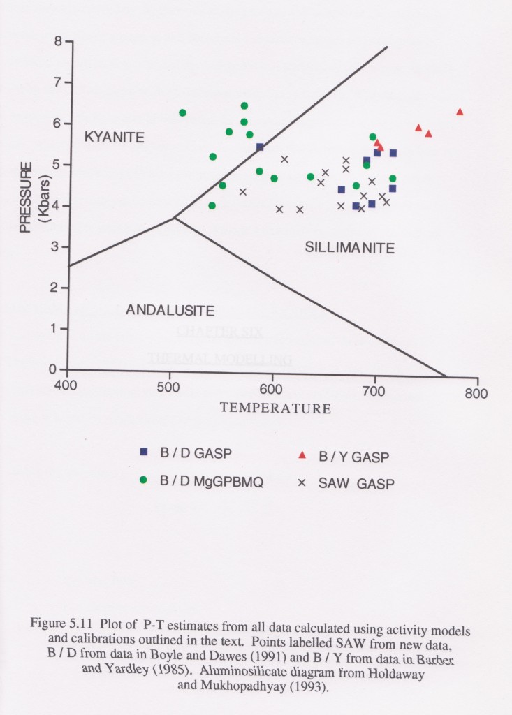
The diagram is taken from my thesis and come from rocks in a small area of Ireland. GASP and MgGPBMQ stand for different sets of geothermometers and geobarometers.

The area contains gabbro intrusions and so variations in temperature are to be expected as I mapped an aureole around them. However the pressure estimates vary a lot as well. The package of rocks is small and peak conditions are close in time, so we would expect a small range of pressure estimates. Looking at these results, the conclusion can only be that thermobarometry is extremely imprecise.

Why is this? Well, the results are from earlier studies as well as my own, so its can’t just be my fault. The truth is that every point on this graph should have bloody-great error bars on it, of the order of 100s of degrees and >1 bar. There is a nice illustration of the difference between accuracy and precision in this. An earlier paper on this area took one of the data sets on this diagram, averaged it and quoted the results to a completely bogus level of precision (e.g. 5.63kbar and 603°C). A fairer summary of the pressure indicated by this data set is “between 3 and 7kbar” or even “in the crust somewhere”.

There are many reasons why these results are imprecise. The calibrations are based on experimental data, which is itself subject to uncertainty. Details of the chemistry (amount of Ti in biotite, fugacity of Fe and so on) can change the results. We have assumed that the mineral chemistry is caused by chemical equilibria being achieved, maybe this assumption is wrong? Hold that thought, for another post.

Finally, we assume that the composition hasn’t changed since the minerals were formed, which is another  big assumption to make

This technique does work, don’t get me wrong. Thermobarometers used on rocks with coesite show very high pressures, measured temperatures are seen to increase in aureoles and so on. A rough estimate of conditions is much better than nothing, but there is room for improvement, no doubt.

THERMOCALC and pseudosections

Things have moved on since I did my thesis.

One of the limitations of of basic geothermometers and geobarometers is that they use only single sets of equilibria to calculate conditions. A rock contains multiple minerals and is affected by multiple reactions, if we make use of more information and more equilibria, we could increase the accuracy.

There are now software programs that do just that. THERMOCALC is a good example. At its heart is an internally consistent thermodynamic dataset for a wide range of mineral systems. The software allows you to use this data in a variety of ways.

At heart, the problem THERMOCALC solves is how to handle multiple dimensions. Conditions of metamorphism vary with pressure and with temperature, but also with bulk composition. Composition is included in the model as extra dimensions, every element or phase adding another dimension. To adequately model a typical silicate rock you need at least 8 dimensions. Imagine that. Actually, no stop! You don’t want a headache.

A typical P-T diagram is a projection of this multi-dimensional space on a 2-D plane, the diagram. The 2-D cross-section through a 3-D beer-glass varies with the angle you hold it (with the view through the bottom being the best). In the same way, the 2-D view through our multi-dimensional space depends on how we slice it. There are different ways to do this, and they give different types of diagram.

THERMOCALC can used to generate the classic petrogenetic grid, where a set of equilibria (reactions) are shown in P-T space. The section through the data here is constrained by taking a particular ‘system’ such as “KFMASH (+q +mu + H2O)”. This example means only modelling potassium, Iron, Magnesium, Aluminium, Silica and water and assuming there is always lots of quartz, muscovite and water. To make the diagrams simple enough to be useful, only reactions that don’t depend on bulk composition are shown.

An especially useful type of diagram is a pseudosection. Here the multi-dimensional data is simplified by taking a projection for a specific bulk composition. This means that all reactions can be shown, even those that depend on the composition of the rock. The diagram is made up of areas, each showing the minerals stable in that area of pressure-temperature space. These areas can be quite small, which means that more accurate estimates of metamorphism can be made – a specific mineral assemblage must have formed in a particular area. Plus evidence of other phases of mineral growth (from inclusions or pseudomorphs) means that sections of P-T-t paths can be inferred.

Pseudosections are a better way of estimating metamorphic conditions as they are based on all mineral equilibria. Plus they are not dependent on measurements of mineral composition. The best use of THERMOCALC is to allow a proper understanding of the metamorphic minerals within a sample and how they relate to the conditions of formation. It is a much more sophisticated approach than simply plugging numbers into formulas.

Further reading

I’ve skimped on the diagrams here, as  I don’t have any of my own. Fortunately there are lots of good places to find more information and good example diagrams.

Dave Waters taught me all I know about metamorphic petrology. His website has lots of material and links but also more detail on how thermobarometry is actually done.

Carleton College has lots of material on the subjects I’ve covered, including much more detail on thermobarometry and P-T-t paths. This is excellent and doesn’t shy from the hard stuff, so stop reading this drivel and get over there, right now.

Or alternatively, look at my other posts on metamorphism.