This is my contribution to the Accretionary Wedge geoblog festival, number 43: My Favourite Geological Illustration. You can read all about it at In the Company of Plants and Rocks.
I was struggling for inspiration on this latest Accretionary Wedge, but this was solved by Matt Hall’s post over at Agile Geoscience, where he talks about a map he produced as part of his degree. Geological maps have captured my imagination since a very early age. I’ve spend many an hour poring over the geological map of the British Isles (particularly the Northern sheet) but of course I had a modern copy, not the William Smith original.
I have hidden away somewhere a very similar undergraduate map to Matt’s but I won’t steal his idea outright. I have a bigger map produced as part of my PhD thesis somewhere as well, but instead I want to talk about someone else’s map.
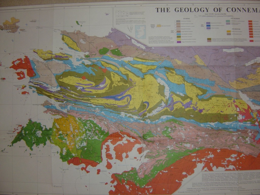
My PhD field area was in Connemara in the west of Ireland, which is an extremely well-known piece of Geology. A fantastic detailed map was published in the 1990s but is based on decades of study by geologists from Glasgow University, Bernard Leake and Geoff Tanner. It is of course in copyright and for sale, but I include an impressionistic photo. I’m sure the Royal Irish Academy will not disapprove.
I’m tempted to rhapsodise at length at the Geology shown by this map, but I’ll be brief. It is a small area (top to bottom about 20km) but it contains such a lot! Such as: evidence of Precambrian glaciations; two overlapping phases of metamorphism, from greenschist to granulite; three major phases of folding; three suites of igneous intrusions, one syntectonic, two post; three tectonic terranes; two terrane boundaries, one a thrust the other an extensional detachment complete with syn-deformational sediments; some world famous marble. Oh, and some sediments around the edge.
One of the greatest pleasures of my PhD research was meeting and disputing with Geoff Tanner and Bernard Leake, standing on the rocks themselves and referring to their fabulous map.


What did you dispute with Tanner & Leake over their map?
The dispute wasn’t around the map as such, more the relative ages of events. I studied the two green blobs towards the top of the map, relating them to the age of the folding. I said they were overlapping both D2 and D3, whereas Geoff Tanner had recently argued they were long after D2. Our discussions were always polite and constructive, indeed Bernard Leake was inclined to agree with me, as his original 1970s mapping of the green blobs in the south had suggested the same timing as I was.
I’ve written about this in more detail here.
What are the green blobs on the map? I went for a bit of stroll through that area recently, and I thought they where Amphibolites. Very interesting location, particularly Doorough Mountain. Thank you.
Currywongaun (as it was spelt on the old maps I used) was my favourite – especially the banding near where the radio telescope was.
The green blobs are mostly amphibolites, but in places the original gabbro minerals are still there (orthopyroxene and plagioclase). I studied the interaction with the surrounding rocks (which were being metamorphosed when the gabbro was intruded). Doorough is interesting as there is a lot of replacement of the gabbro by water and silica, leaving amphibolite with quartz in it. I never did any geochemistry on this, but somebody should….
More here
Thank you Metageologist for the reply, I may head up to Currywongaun to get a closer look. I saw some of those interesting textures on the south east slope of Doorough. Amphibole rich patches ‘floating’ in the gabbro. Looked somewhat like a restite to me, but I wasn’t sure. I ventured further west in and around Leterrfrack, and had very good weather and visibility, it seemed to me, as I like to draw a lot that Doorough was a structural apex in the area and the surrounding hinterland to the west may have been pulled in toward it. Im heading to Roundstone and the surrounding areas tomorrow. I think some geochem was done: http://jgs.lyellcollection.org/content/158/5/843/F1.large.jpg
but I hope more is done too. Thanks again, all the best. Finn
*If Restite as a metasomatic fluid is possible…
This is perhaps a strange question, but I was wondering if you knew of any places where this map is still in print? Love the site, it is always fun to encounter other geologists on the web as well as in the field.
I’m glad you like the site, thanks.
I think the map is available on Amazon (and no doubt other places). It comes packaged with a short guide book to the geology of the area and quite a few other maps of more detailed areas.
Simon