Bumpy ice: proof of a Martian water cycle?

Some interesting data from Mars Odyssey about the distribution of sub-surface ice on Mars were published in Nature last week by Joshua Bandfield at Arizona State University (see also here and here). Mars Odyssey had already detected the presence of extensive water ice at depths < 1-2m by using its Gamma Ray Spectrometer to measure the concentration of hydrogen. However, this instrument does not have a very high spatial resolution (of the order of hundreds of kilometres), so cannot resolve any local variations in the thickness or depth of the subsurface ice layer.
In contrast, the Thermal Emission Imaging System (THEMIS) has a much higher resolution – of the order of 100 metres. However, inferring the presence of subsurface ice with this instrument is a slightly more indirect process. Detection is based on the idea that martial soil, or regolith, will have a much higher thermal inertia when bound together with ice than it does as a loose aggregate; this means that regions with a lot of ice near the surface will cool or heat up more slowly in response to daily and seasonal changes in temperature than areas where there is no ice, or it is more deeply buried.
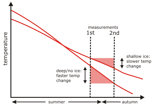
In order to exploit this principle, Bandfield used THEMIS observations of the same region in mid to late summer and early autumn to calculate how much the ground temperature changed as Mars cooled down. Because changes in air temperature take time to propagate into the subsurface, the amount of cooling depends mostly on the thermal properties of the top metre or so of the Martian surface. The figure below, adapted from Figure 1 of the Nature paper, shows that if there is shallowly buried ice, the thermal intertia of these top few tens of centimetres is high, and the temperature change is small. If the ice is buried deeper, beneath a thicker layer of unbound regolith, the thermal inertia of the surface layer is lower and the temperature change is larger.

marsdt.png

Continue reading

Categories: geophysics, paper reviews, planets

To PhD and beyond!

Junior academics often seem a slightly embittered lot. However, it’s important to extract the right messages from the bitterness. Remember that the four, five or more years we spent working towards our PhDs were hard, physically and mentally; all that time on the same project, most of it spent either worrying that you don’t have any data, or worrying that the data you do have make no sense; finding yourself in the lab at nights and weekends, but also finding completion to be an ever mutable, ever-distant target; it’s no wonder most people go a little stir crazy, and that’s when it goes well. My PhD worked out pretty well (especially compared to some horror stories out there – I was fortunate to have a supervisor who stuck up for me when it counted), but for a long time it didn’t look that way, and I’d be lying if I told you that looking back didn’t occasionally inspire the odd shudder or five.

Continue reading

Categories: academic life

Know thy co-ordinate system

Paleomagnetism has many complications and subtleties – as I’ve learnt the hard way in the last six years, it’s not a simple matter of sticking your sample in the machine and getting a direction out. For a start, the direction that the magnetometer initially spits out is often not in a geologically meaningful reference frame. The magnetic intensity of a sample is usually measured along orthogonal x, y and z axes, defined such that the top of a sample is the x-y plane, and the z axis points downward through it.

coord1.jpg

However, if we examine a paleomagician in the act of drilling for a sample, we see that he is drilling into the outcrop at an angle. Therefore, the x-y plane defined by the top of the sample does not correspond to the real horizontal plane; neither does the z-axis of the core point straight down with respect to the Earth. This skewing of the co-ordinate axes means that the direction of the magnetic vector you measure in the lab is also skewed away from the ‘real’ direction. Plus, because each core is drilled at a different angle, this skew will be different for every sample from an outcrop, so even very similar actual magnetization directions might appear to be very different as measured.

Continue reading

Categories: geology, geophysics

Dear God, I would like to file a bug report

How completely true. Maybe we should compile a requested features list ready for the Second Coming.

conspiracy_theories.jpg

(click on link or frame above to read the full comic at xkcd).

Categories: bloggery

Geological Basics: the art of Paleomagic

If I’m ever going to talk about my own research in any detail, I’m first going to have to explain a little (or a lot) about the field I fell into almost by accident, paleomagnetism. Literally ‘ancient magnetism’, paleomagnetism is the study of the signals left in volcanic and sedimentary rocks by the Earth’s magnetic field; signals which can be preserved over millions of years of geological time. Paleomagnetic and other rock magnetic measurements are typically quick and non-destructive, and can potentially be usefully applied across the earth sciences – in fields as diverse as tectonics, geochronology, paleoclimate, and physical oceanography.
So, what is the nature of the Earth’s magnetic field? The shape and intensity of the field fluctuate over time, as records of secular variation – the changing position of the magnetic north pole with respect to the geographic north pole over the last few hundred years – illustrate. However, if you average these variations over a few thousand years, to a first approximation the field closely resembles a dipole centred near the axis of rotation.

geomag.gif

Continue reading

Categories: basics, geology, geophysics, palaeomagic