
![]() The Global Positioning System has completely revolutionised how geologists study the deformation of the Earth. If you leave a GPS receiver in a fixed location for days, months and years, it is precise enough to measure motions on the millimetre scale, allowing us to track strain building up across active faults, and even the incremental drift of the tectonic plates themselves across the Earth’s surface. But on the 26th December 2004, stations across a sizeable slice of the Earth’s surface suddenly found themselves being jerked around a bit more rapidly. The plots below are from stations in southern India and northern Taiwan, respectively.
The Global Positioning System has completely revolutionised how geologists study the deformation of the Earth. If you leave a GPS receiver in a fixed location for days, months and years, it is precise enough to measure motions on the millimetre scale, allowing us to track strain building up across active faults, and even the incremental drift of the tectonic plates themselves across the Earth’s surface. But on the 26th December 2004, stations across a sizeable slice of the Earth’s surface suddenly found themselves being jerked around a bit more rapidly. The plots below are from stations in southern India and northern Taiwan, respectively.
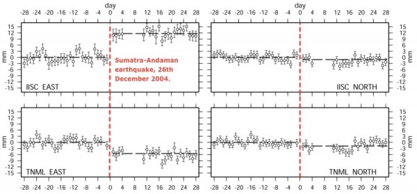
If you are thinking that date sounds a bit familiar, you’d be right: that jerk is the signal of the massive magnitude 9.3 earthquake that ruptured a 500 km length of the Sunda Trench off the coast of Indonesia on Boxing Day 2004, and unleashed a devastating tsunami.
What’s impressive is that we are seeing permanent deformation of the crust due to motion on a fault (what is known as coseismic deformation) an extremely long way away. As we can see on the map below, the Indian GPS station IISC is some 2,300 miles away, and the Taiwanese station TNML is 3,600 miles away, from the Sunda Trench. And yet, even at that distance, the Sumatra-Andaman earthquake shifted the land beneath these points about a centimetre – a little less for the Taiwan, a little more for India.
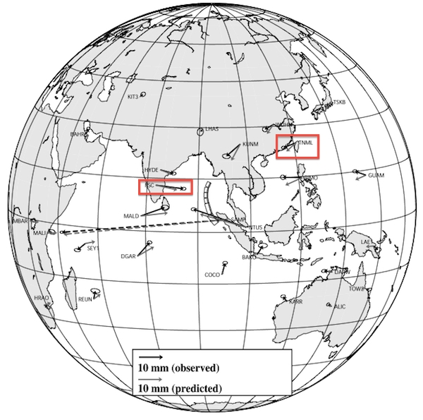
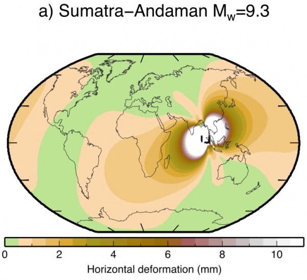
The figure above also compares the actual motion observed with GPS (black arrows) with predictions from a model of the Boxing Day rupture (grey arrows). What this figure doesn’t show is the predicted coseismic deformation at places not occupied by GPS stations. Fortunately, a paper just published in the Journal of Geophysical Sciences contains a much nicer visualisation of the output of a similar model. This model – rather mind-blowingly – indicates that the Sumatran-Andaman earthquake rupture directly deformed a sizeable fraction of the Earth’s surface, including Africa, Arabia, the eastern half of Asia, and most of the Americas.
Paul Tregoning and his co-authors have gone on to calculate the cumulative coseismic deformation resulting from all 15 magnitude 8 or greater earthquakes that have occurred since the turn of the millennium on the Earth’s surface. Unsurprisingly, the big three earthquakes in this period – the Sumatra-Andaman, the magnitude 9.1 Tohoku earthquake in March 2011, and the magnitude 8.8 Chilean earthquake in February 2010 – are the major contributors, but the smaller ones fill in some gaps in the southwest Pacific.
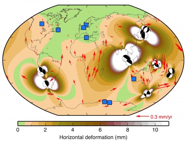
Modelled global coseismic deformation due to all M 8+ earthquakes since 2000, from Tregoning et al., 2013
Basically, outside of western Europe and the Arctic Circle, pretty much the entire surface of the planet has been shifted at least a millimetre or two by an earthquake since the turn of the millennium. And this has real world consequences. The interiors of the Earth’s tectonic plates are generally assumed to be rigid and undeforming, and are used as a fixed reference point for measuring deformation at the plate boundaries. The red arrows in the figure above show exactly how much you’d be wrong if you are assuming that for a given point on the Earth’s surface. Even when you’re a long way from a plate boundary, coseismic deformation from distant, large earthquakes is causing your ‘fixed’ reference point to be not so fixed. Spooky tectonic action at a distance, indeed.
References
Corné Kreemer, Geoffrey Blewitt, William C. Hammond, & Hans-Peter Plag (2006). Global deformation from the great 2004 Sumatra-Andaman Earthquake observed by GPS: Implications for rupture process and global reference fram Earth, Planets, Space, 58 (2), 141-148
Tregoning, P., Burgette, R., McClusky, S., Lejeune, S., Watson, C., & McQueen, H. (2013). A decade of horizontal deformation from great earthquakes Journal of Geophysical Research: Solid Earth, 118 DOI: 10.1002/jgrb.50154