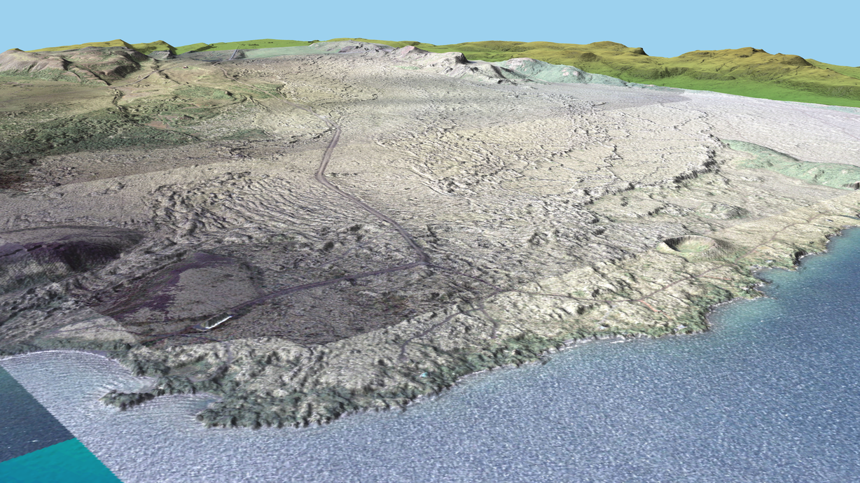
Orthorectified aerial photographs of the Nesjahraun, Iceland, draped over LiDAR-derived topography visualised in GRASS’s NVIZ module. Click to enlarge.
The UK National Environment Research Council’s Airborne Research and Survey Facility (NERC ARSF) is an aircraft used for scientific research. The on-board instruments include LiDAR, high resolution camera, and multispectral and hyperspectral infrared scanners. The aim of this post is to share an article and slides from a talk that I gave in 2009 that demonstrate how these data can be processed with free and open source tools.
The slides and articles also illustrate some of the ways that GRASS GIS can be used to process remote sensing data in general.
- Talk slides: From ASCII files to orthophotos: The processing of high-resolution aerial survey data using open source GIS software. (6.7 Mb)
- Article: From ASCII files to orthophotos: The processing of high-resolution aerial survey data using open source GIS software. (1.1 Mb)
Getting started with GRASS GIS

Multispectral infrared data channels combined in GRASS to highlight different landscape/vegetation features. If you have visited Iceland, you may recognise the Nesjavellir geothermal plant, with its steam and warm river. Click the image to enlarge.
GRASS GIS is a fully-featured open source GIS package. In talk and article I describe using it to process LiDAR point clouds, orthorectify aerial photos, calculate slope/aspect maps, digitise geological information, import field data and to visualise and export data in a variety of formats. From a remote-sensing perspective, the Image Processing features include things like image classification and fusion.
Early versions of GRASS were mainly command-line based, so the learning curve can be a bit steep, but the GUI has improved significantly (especially from 6.4.2 onwards). The command line has the advantage of easy scripting, and the latest versions are moving to Python which will make it simple to include GIS processing in other workflows.
The following tips will help you get started with GRASS:
- Install GRASS from the website. As it was initially developed on the UNIX operating system, the Linux and Mac versions are better. Windows users should install the OSGeo4W package, which also includes a number of other useful programs e.g. QGIS.
- Download+print/buy a copy of Open Source GIS: A GRASS GIS Approach and have an actual physical copy beside you as you work. It is an excellent reference.
- Visit the pages for first time users on the GRASS website and learn about locations and mapsets.
- Join the ‘grass-user’ mailing list. Your questions will be answered very quickly (often by the developers themselves) and you can see examples of how others use it.
- Bookmark the GRASS Search Engine, where you can often find answers in the mailing list archives.
Further reading

Orthorectified aerial photographs of the Nesjahraun, combined with digitised field data exported to GoogleEarth via GDAL. Click to enlarge.
To see a list of open source tools useful to geoscientists, see All the software a geoscientist needs: For free! There is also a list on Wikipedia of free and open source geophysics software.
The data that I processed was used in a study of an Icelandic lava flow that went into a lake. You can see how it was used in the following articles:
- Stevenson, J. A., N. C. Mitchell, M. Cassidy, and H. Pinkerton (2011), Widespread inflation and drainage of a pahoehoe flow field: the Nesjahraun, Þingvellir, Iceland. Bulletin of Volcanology, doi:10.1007/s00445-011-0482-z.
- Stevenson, J. A., N. C. Mitchell, F. Mochrie, M. Cassidy, and H. Pinkerton (2011), Lava penetrating water: the different behaviours of pahoehoe and ‘a‘a at the Nesjahraun, Þingvellir, Iceland. Bulletin of Volcanology, doi:10.1007/s00445-011-0480-1.


Hi John, I wonder if the data you used is publicly available for academic research only purpose?
Hi Arif,
Yes, all NERC ARSF data has to be posted to a repository within two years after the project. If you register with an account, you can download my data (Flight: IPY07-02) or any others. The catalogue is here:
http://catalogue.ceda.ac.uk/uuid/55d1c9b6e7a4ce41b7a6f8416b7b6261
Cheers
John