The Holocene: from the Ice Age to the Age of Rice

Every day history is being made. This is true for geology as well. Out at sea layers of sand or mud are being laid down that will become the geological records of the future. The period of geological time that we are in right now is called the Holocene epoch, which is part of the Quaternary period, which is part of the Cenozoic Era. Let’s take a step back and tell the story of how we got to the Holocene.

The Cenozoic Era started 66 million years ago with the extinction of the dinosaurs, at a time when massive volcanic eruptions and a huge meteorite impact caused enormous changes to life on earth. With the dinosaurs gone (apart from birds, which are types of dinosaur – just look at their feet!) mammals were able to evolve into new species. The earth’s tectonic plates continued their slow dance. The Atlantic ocean continued to open, splitting Europe from North America (they used to be joined together). The Indian plate (which used to sit alongside Africa, Antarctica and Australia) moved quickly north and around 60 million years ago punched into the Asian plate. This started to form the huge mountains of the Himalaya, the high Tibetan Plateau and the the Tian Shan. Moving through the Cenozoic, animals and plants and the geography of the earth become more familiar. Grasses first become important around 40 million years ago. Also animals that eat grass, like horses and cattle. One thing that was different was the climate, which was much hotter, with higher levels of CO2 in the atmosphere and no ice caps.

Significant glaciers started to form in Antarctica around 34 million years ago. By the Quaternary period the earth is in an Ice Age, with large ice caps on Greenland and Antarctica and permanent glaciers in high mountains around the world. The Quaternary started 2.588 million years ago and it hasn’t ended yet. There have been ice ages before, during the Proterozoic – when the earth nearly froze completely – also in the Ordovician and the Carboniferous. These are times when the levels of CO2 in the atmosphere are relatively low. As ice caps lock up lots of water, sea levels tend to be low also. The amount of ice is relatively sensitive to changes of the earth’s spin causing changes in the amount of sunlight the earth receives. Tiny variations in the spin of the earth, caused by the irregular tug of other planets in the solar system are called Milankovitch cycles. There are different Milankovitch cycles that move at different speeds, so the pattern is complicated, like listening to many drummers who are moving at different speeds. The main effect is a pulse of between 40,000 to 100,000 years. We see this as dramatic changes in the volume of ice and of the climate of the earth. These are called glacial and interglacial periods and the earth has moved back and forth between them through the Quaternary.

We know what an interglacial period looks like, as we are in one right now. During past glacial periods, New York was covered by a layer of ice many kilometres thick, as was northern Europe. In China, the ground was permanently frozen as far south as Beijing and most areas were desert. Finely ground rock, from ice caps and glaciers further north or in the Himalayas was blown across this desert building up thick deposits of a fragile yellow soil called loess. An area called the Loess plateau covers the upper and middle parts of the Yellow River and makes excellent farmland. The soil erodes easily and the Yellow River’s name comes from the large volumes of eroded loess that it contains.

The Holocene epoch started 11,700 years ago and it’s the period of time since the end of the last glacial period. During it the climate has been relatively stable, with limited ice cover. But there have been many changes over that time. The first half of the Holocene saw areas that had been covered by ice slowly move to more modern conditions. Sediments in lakes contain ancient pollen and allow the plant species in the area to be identified. In many places there was a slow return of forests, with more and more species becoming established as thousands of years passed. Tropical rain forests, like the Amazon, were quite restricted during the glacial period and they also grew rapidly during the early Holocene. Some climates were very different. Parts of what is now the Sahara desert in Africa was a fertile place during the Holocene. Here we have evidence from ancient humans. Cave paintings show the hunting of giraffes and other large animals in places now barren desert.

Human beings are the most remarkable thing about the Holocene. The history of human evolution is complicated. Creatures clever enough to make stone tools have been around for 2.5 million years, but the oldest known fossils of modern humans (Homo Sapiens) are 300,000 years old. By 50,000 years ago humans had spread from Africa across much of the world and were using sophisticated stone tools and burying their dead. They were as clever as us, but had very little technology to help them.

Even with simple stone tools, humans made an impact. The ground in Siberia is frozen. Within it people find the corpses of extinct animals, like giant wooly elephants called mammoths. These animals used to be extremely common, but they became extinct during the early Holocene. Why? The changing climate might be responsible, but some believe that intense hunting by human beings is the main reason. In many sites across the world we have evidence of humans killing and eating large numbers of mammoths and other extinct animals. There is a debate about the most important cause of extinction, but it’s clear that even simple stone tools could be extremely effective.

Also human brains can be deadly. One effective method of hunting mammoth and other animals that live in herds was to scare them and drive them over cliffs, where they fell and died. During the Holocene humans took advantage of the improving climatic conditions to develop more and more new skills and technologies. The impact of increasing numbers of humans and their increasing ability to change the earth and the animals and plants upon is a theme of the later Holocene.

When populations of humans are small, we can live by hunting animals such as mammoth and gathering wild foods, like nuts or shellfish. Such foods are rare, so groups of humans would often move, following migrating animals, moving to different foods sources throughout the year or simply moving to new places. From the early Holocene we have evidence in the Middle east of the first villages or towns. For people to become settled, we need a reliable source of food that can be stored to provide food all year round. These first villages were based on harvesting grains from grasses – wild versions of modern day wheat or other cereals. Over time, selection of the best wild grains lead to the breeding of domesticated versions. These may require human intervention to thrive, but gave a good yield of food. A similar process occurred with animals. Wolves became dogs, who could help defend herds of domesticated sheep from attack by non-human predators. Hunter gatherers became farmers. Over time the same process affected fruit and other vegetables. Plants with small bitter fruits were slowly changed by selecting the best ones to end up with the large and juicy fruits we enjoy today. Very little of what we eat today is truly wild.

This process happened in different areas based around different foods. People in Central America domesticated maize from around 8000 years ago. In China and southeast Asia people started growing rice and eating it from around 7500 years ago.

Once people have worked out how to grow reliable sources of food, they can move across the land, spreading their seeds and animals as they go. We can trace this via records of pollen in lake sediments and other wet places. In places that were previously covered in trees, farmers would remove them, dramatically changing the landscape. The natural regeneration of forest, with seeds growing into trees is broken by domesticated animals like sheep eating the young trees. The wide open mountains and fields of the British countryside, for example are entirely man-made.

In a group of hunter-gatherers, groups of people tended to be small and most were involved in producing food. As farming villages became towns, a group of people emerged who did not need to directly work to produce food. These people – kings, priests, merchants, craftsmen and others had the time to produce new things, like writing, organised religions, metal objects and so many other things. In some places the nature of the farming required many people to work together. In the Mesopotamian basin (modern-day Syria and Iraq), where some of the earliest towns were formed, systems of irrigation were required to get water from narrow rivers into broad areas of farmland. Technology itself sometimes also encouraged the growth of large kingdoms. Bronze is a metal alloy produced from a mixture of copper and tin. In the eastern Mediterranean of Europe there is copper, but the tin had to come from far away, like Afghanistan or the British Isles. Only large kingdoms or empires had the resources to bring together such distant materials.

The period of time when people are using Bronze is called the Bronze Age and it was followed by the Iron Age and so we are moving into history rather than geology. Let’s take a step back and consider this enormous change in human activity from the point of view of the wider planet. Even at the start of the Holocene, humans may have been causing extinctions of animals. The rate of extinction has only grown since then, with no sign of stopping. Direct hunting is not the only cause. Farming landscapes are very different from ones untouched by man and while some animals have adapted (rats, for example), many have not.

Some human impacts on the planet that we think of as modern are surprisingly old, for example pollution. Ancient layers of ice in the Greenland ice cap are a record of atmospheric pollution. Each layer is a record of ancient snow, plus trapped bubbles of air. Studying this record shows traces of lead pollution from Roman mining in Spain from over 2000 years ago. Similar records from South America show the traces of local mining from 3500 years ago.

These ancient traces of human activity are dwarfed by the current impacts. During the Quaternary and most of the Holocene, CO2 levels slowly varied in step with Milankovitch cycles. Human burning of fossils fuels has dramatically changed this. Levels of CO2 are now higher than they have ever been before in the Holocene or even the Quaternary. Some geologists argue that the Holocene is over and that we are now in a new geological Epoch, that they call the Anthropocene.

First publication by Xiaoduo Media in Front Vision. Front Vision is a Chinese online science magazine for children. Reproduced with permission.

The geological history of the earth

To understand the past, we divide history into different pieces, some big, some small. Human history has been divided into Ages, (e.g. Stone Age, Bronze Age) then smaller periods like Dynasties, then by the reigns of single rulers. Geologists deal with much longer periods of time, but they divide the history of the Earth in a similar way. A trained archaeologist can find a piece of pottery and know that it was made during a particular period of time – the Ming Dynasty say. Geologists use fossils – the remains of ancient animals – in the same way. To find out how, let’s learn how about the people who first discovered how to do this.

Nineteenth Century Britain was a time and place where rapid development of industry and advances in science went hand in hand, each helping the other. William Smith worked as an engineer involved with canals and coal mines and so saw a lot of sections cut through rocks. He realised that he saw the same layers in different places, always in the same order and with the same types of fossil in each layer. He proposed that this was a universal scientific “law of faunal succession”. In any series of layers of sedimentary rock, as you look at each layer going up, fossils will appear in a specific reliable order. There are fossils in the coal-bearing rocks that are not seen in the younger limestones higher up, instead different ones are seen, sticking out of the walls of buildings in Oxford and Cambridge Universities. The rocks on top – the youngest – like the Clay under London contain a different set of fossils again. William Smith was the first person to create a geological map of Britain, that was published in 1815. He used his understanding of the fossils and his law of faunal succession to help him create the map. He produced ‘cross-sections’, pictures of a vertical slice down through the earth. These are of practical use. Dig down into rocks that you know sit above rocks that contain coal and you can make a mine. Dig down into older rocks and you are just wasting your time.

Modern scientists would use different words, but William Smith’s ideas are now known to be correct and useful in understanding geology across the world. Stratigraphy is the modern name for the study of layers of rock. Nicholas Steno, a European scientist working a century before William Smith first defined the laws of stratigraphy. These ideas are simple. Think about an old house that has been decorated many times. The walls are covered in many layers of paint, each on top of the other. If you think about it, it’s obvious that the layers closest to the wall were painted on first, and the ones above later. Think of a nail stuck in the wall. It will cut the layers of paint that were there when it was banged in. If it’s covered by different layers, then they were laid down after the nail was put in. Apply these ideas of layers of rock laid down on the surface of the earth and you get the laws of stratigraphy. Using fossils to understand these layers is known as biostratigraphy.

European scientists in the generation after William Smith studying rocks in other countries found the same fossils, but in different types of rock. What might be a limestone in one country could be a mudstone in another, but with the same types of fossils. Realising that these rocks were of the same age they started naming periods of time defined by the fossils. These are the geological periods that you may be familiar with. The oldest rocks that contain obvious fossils was named the Cambrian period after the name for Wales (part of Britain) in Latin (an ancient European language). The Ordovician and Silurian were named after the Latin names for ancient peoples from Wales. The Devonian was named after a part of Britain called Devon, the Carboniferous after the element Carbon as these rocks are rich in coal. The Permian is named after a Russian city, the Triassic in Europe contains a series of three different types of rock and ‘tri’ means three in Latin. The Jurassic was named after a mountain range in France, the Cretaceous after the latin for chalk, a rock common at this time.

The geological periods were being named when Charles Darwin was a young man, studying geology and other sciences. For example he studied with Adam Sedgwick who soon after named the Cambrian period. At the time, people were realising that the earth must be very old. They could see that layers of rock were kilometres thick. The rocks themselves were like like layers of sand seen in the modern sea or rivers. Knowing that layers in the modern world form slowly they realised that kilometres of rock would require millions of years to form.

A world that was millions of years old. Fossils that changed gradually over time. These are the ideas that were in Charles Darwin’s head as he sailed across the world studying modern plants and animals (and Geology) on a sailing ship called HMS Beagle. All these experiences led him to produce his theory of evolution by natural selection, the foundation of modern biology.

The theory of evolution also explains why biostratigraphy works. As animals and plants slowly change and evolve into new species, the fossils found in rock layers also change. Once an animal becomes extinct it is never seen again.

We now know that the way animals and plants change over time isn’t always a calm gradual process. Mass extinctions are events where many types of creature die out, due to meteorite impacts, or massive volcanic eruptions or other reasons. Many of these sit on the boundaries between different geological periods. The extinction of the dinosaurs happened at the Cretaceous-Cenozoic boundary. The biggest extinction ever – sometimes called “The Great Dying” – happened at the transition between the Permian and the Triassic. At this time 96% of marine species became extinct as massive volcanic eruptions poisoned the air and the seas.

Geological timescales – taken from Wikipedia

Often geologists talk about how many millions of years old something is. We were only able to measure the age of rocks in the Twentieth century, once we understood radioactivity in rocks better. Using fossils to divide time doesn’t require you to know exactly how old they are, just that this rock is older than that, or that these are the same age. Geological periods are the most familiar divisions of geological time, but there are others, some bigger, some smaller. In the nineteenth century, all rocks older than Cambrian period were lumped into the ‘PreCambrian’ and were thought to have no fossils at all. Now we are able to find out the ages of rocks without fossils, using radiometric dating. PreCambrian rocks make over 85% of the history of the earth, so geological periods called Eons are used to divide up this vast time. All of the Cambrian and later are known as the Phanerozoic eon, the word means ‘visible life’ in the Greek language. The eon older than this, from 2500 to 541 million years ago, is the Proterozoic, meaning ‘earlier life’. Even older rocks are from the Archean eon, meaning ‘beginning’. Rocks on earth older than 4 billion years old (they are very rare) come from the Hadean eon. The earth at this time was extremely hot, covered in molten rock and hit by frequent meteorite impacts, conditions seen as hellish. Hadean is named after Hades the Greek god of Hell.

Coming down a step, between the vast Eons and the more familiar Periods, we have Eras. The Proterozoic is divided into three, early, middle and late, or Palaeoproterozoic, Mesoproterozoic and Neoproterozoic. The Phanerozoic (Cambrian and later) is also divided into old, middle and new. These eras are the Palaeozoic, during which life first left the seas onto land, Mesozoic, when the dinosaurs roamed the earth and the Cenozoic when mammals became dominant.

The better known periods of the Phanerozoic are divided up still further into Epochs. Typically a period is divided into 2 or 3 epochs, often early, middle and late. Our next divisions are called Ages. Let’s get into some examples. The Cambrian period was named after Wales in Britain. Its youngest Epoch is the Furongian, meaning Lotus, another name for Hunan province in China. The Furongian Epoch is split into 3 Ages, the first two named Paibian (named after a village in Hunan Province) and Jiangshanian (named after a village in Zhejiang Province). The third Age of the Furongian Epoch is not yet named. All of these divisions of time are known as ‘chrons’. The term can be used to refer to any slice of time that can be well defined, even those shorter than geological Ages. Why are some Epochs and Ages named after villages in China? It’s because that when dividing finer and finer periods of time, it’s important to have a well-defined definition that can be used in rocks across the world.

Wales has lots of rocks of Cambrian age, but Hunan province in China has some of the best sequences of rocks from the Furongian Epoch. What geologists are looking for are continuous sequences of rocks rich in marine fossils that change rapidly over time. It’s not uncommon for piles of sedimentary rock to have periods of time when no sediment was deposited, when the record is broken. The Furongian Epoch, starts with the Paiban Age. It’s defined officially defined as the first appearance of a fossil trilobite species, called Glyptagnostus reticulatus (no, I don’t know how to pronounce it either). This animal was a little like a woodlouse that lived in the seas, widely across the planet. It’s found today in six different continents and so a perfect way to divide up time. The official reference point that defines the start of the Paiban is a sequence of rocks near the village of Paibi. This place, called a GSSP (for Global boundary Stratotype Section and Points) was chosen by a global group of geologists called the International Commission on Stratigraphy (ICS). Their mission is to define the boundaries between all geological Ages in terms of specific fossils and a place that best shows the boundary. More poetically (but not accurately) GSSPs may be called ‘golden spikes’, a place where humans have nailed down the flow of time to particular place and event. The work of the ICS is not complete, they have more ‘golden spikes’ to define. Maybe they’ll put one near where you live? Maybe they already have.

Not all golden spikes are defined by the appearance of disappearance of fossils. The boundary between the Cretaceous Period and Palaeogene Period is defined by a layer enriched in Iridium a rare element on earth but more common in space. The layer was formed by a massive meteorite impact (the crater is in the Mexican Gulf in North America). This is also when the dinosaurs became extinct which is probably no coincidence).

The basic principles of stratigraphy – layers above other layers are younger, for example – are universal. What if you had a planet with no fossils, that you’ve never visited but where you had a good set of photos sent by a robot, could you define geological Periods? Of course! We’ve done it for Mars after all. Martian geological periods, the Pre-Noachian, Noachian, Hesperian and Amazonian cover the same period of time as earth ones, but are entirely different. They are far less well defined too (no Epochs or Ages) but they answer the same human questions – How old is that? What’s its history? What stories can we tell from it?

If intelligent beings in the future were to look at the earth, they’d be able to use stratigraphy to understand the geological history of our times. Probably they’d use the same ideas and look for extinctions of animals, or unusual layers of rock to divide up time. What would the layers being laid down right now look like? They’d be interesting, I think.

First publication by Xiaoduo Media in Front Vision. Front Vision is a Chinese online science magazine for children. Reproduced with permission.
A refolded fold from Scotland

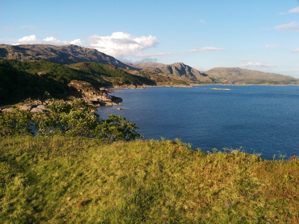
Standing on the shores of Loch nan Uamh I was feeling distracted. There was a lot to attend to. Behind me was a flat strip of grass, growing on a beach deposit now left high and dry by the crust’s slow straightening of its spine after the weight of a huge ice cap melted away. Perched above the fossil beach was a Victorian country house where incredibly brave people from across Europe had trained before being dropped into Nazi-occupied Europe to wreak righteous havoc.  To my left sits an Iron age hill fort and straight ahead a sublime view demanding I pay attention to its wild empty peninsulas, small forested islands and wide rolling sweep, all under a cloudless sky. The drift of my thoughts towards why this landscape is so wild – heartless landlords and ‘improvement’ leading to clearance and gaelic songs sadly sung on a ship to Canada – is interrupted by my family. Not unreasonably they want me to stop staring into space and attend to their games on the rocky beach.

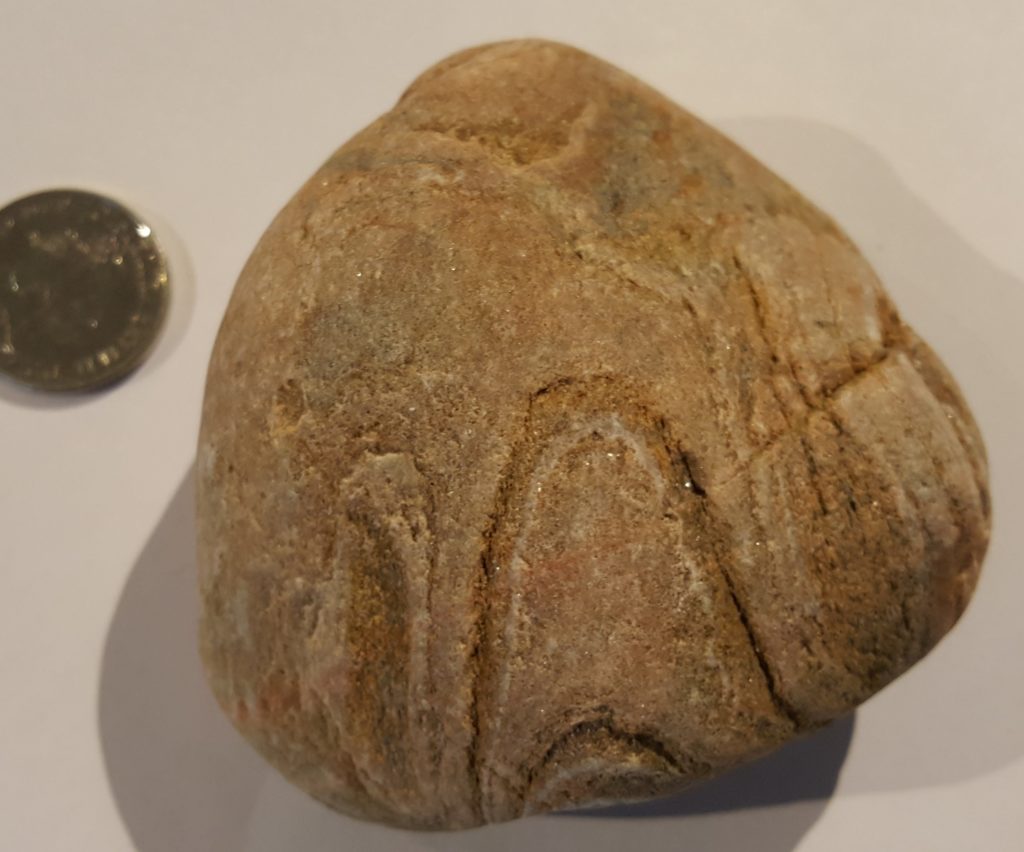
Fatherly duties still leave time for me to assume the geologist’s pose and stare at the ground, assessing the cobbles at my feet. I snaffle a nice bit of granite first. Then a nice piece of pinkish folded quartzite catches my eye and slips into a pocket to be forgotten as the glorious day rolls on.

Let’s have a look at it.

You can see how it caught my eye. Just short of a billion years ago it was formed as different layers of sand, some nearly pure quartz, others more muddy. It’s since been heated and squashed within the earth. The quartz is still quartz but the mud is now shiny mica.

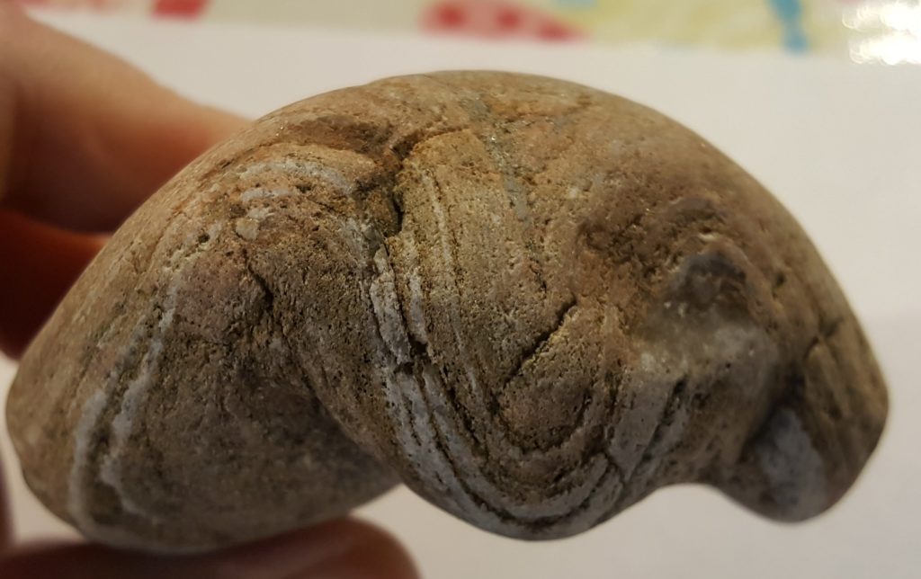
What were once flat layers 1  are now folded. The pattern we see is the intersection of a 3D fold with the complex rounded surface of the pebble. Call the image above as a view of the top of the pebble. Let’s rotate it round (it sits beautifully in the hand, like a heavy cricket ball) and look at one of the sides.
These sigmoidal shapes are classic folds. You can almost visualise the rock sitting in a clamp being squashed horizontally to turn flat lines into wavy.

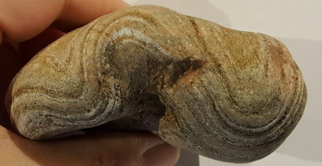
Rotate the sample 180 degrees around  a vertical axis to see the other side of the sample and you see the same folds coming out of the other side of the rock.


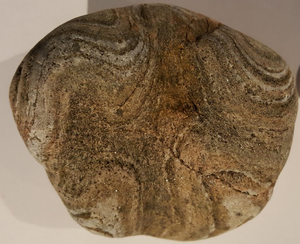
Looks simple. But appearances can be deceptive. Let’s rotate the sample to look at its underside (the side my thumb is holding in the picture above).


At the top of this photo you can see some of the edge in the preceding picture. So the folds we’ve seen before have their crests and troughs running vertically through the image. You can see that, but not just that. The darker layer sitting in the middle of the shot runs from top to bottom, marking a trough in the folding, but it is forming a rough cross shape, not a single line as I would expect.

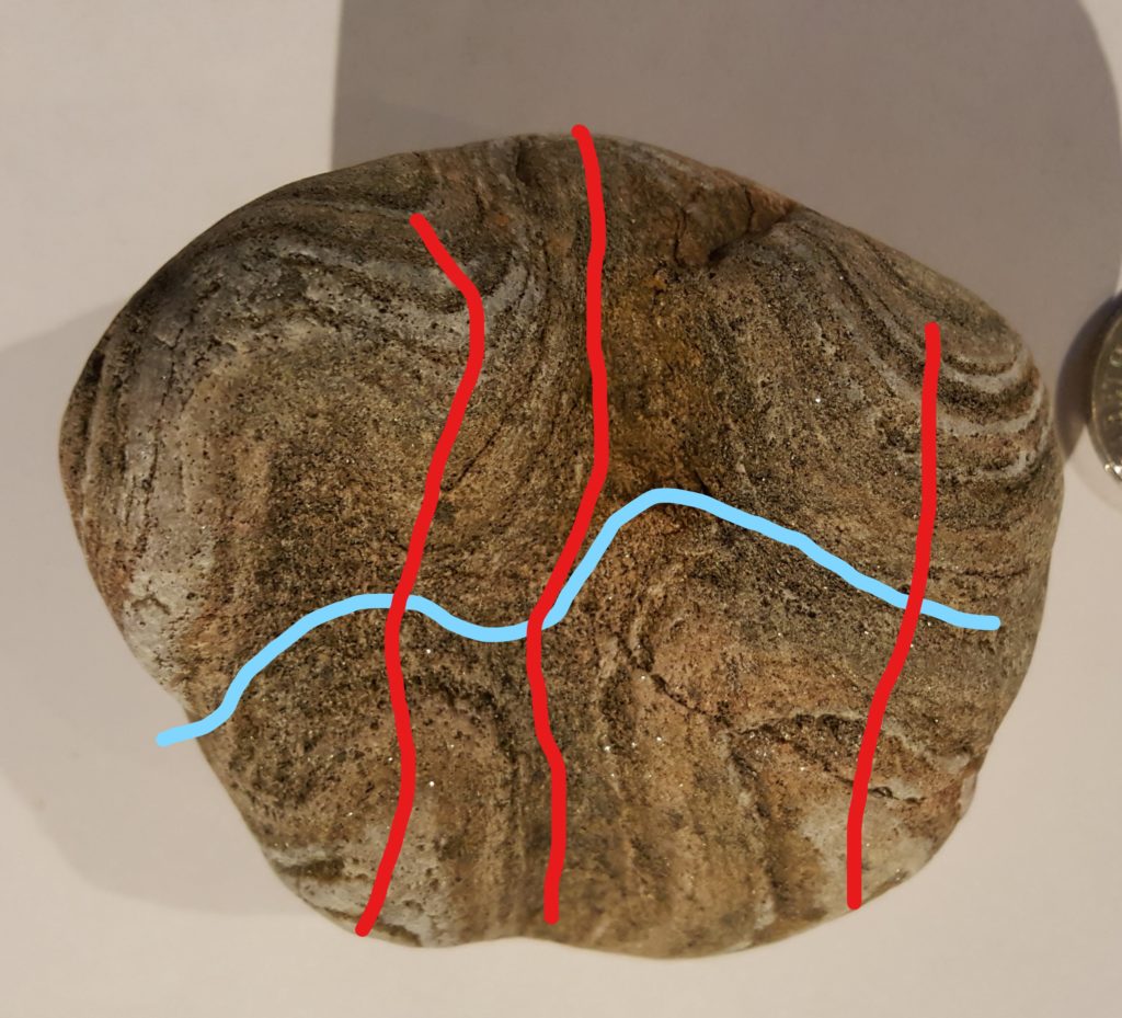
There are two sets of folding in this sample. I’ll try and annotate that for you.

In red I’ve drawn most of the troughs and peaks of the main folds. The ones we’ve seen now from three angles. The blue line shows what I reckon is an earlier fold, where the crest of the trough is itself folded by the red folding.

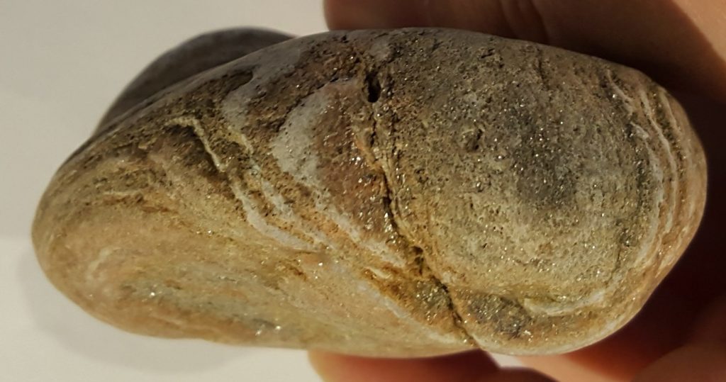
Here’s a view looking at the side again, the edge on the right side above. It’s at an angle of 90 degrees to the other side views. We are looking down on a trough shape made by the earlier blue folding, now bent around by the red folds.

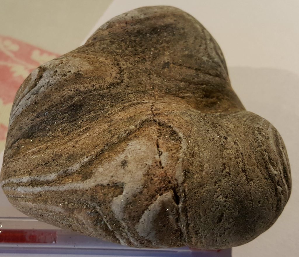
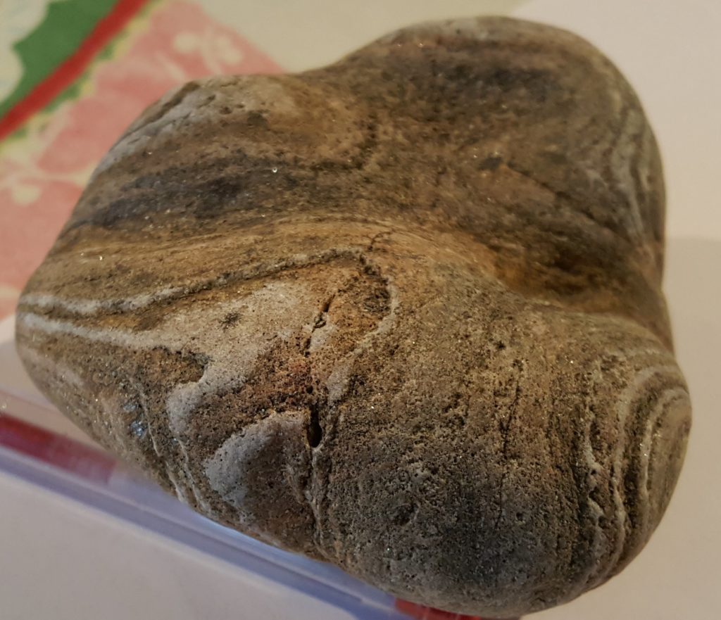
Here are some oblique views in the same direction, that makes the saddle shape formed by the two sets of folding more obvious. This stuff is hard to see from photos. It’s easier to visualise the three-dimensional patterns when you’ve got the sample in your hand, but even then I didn’t notice (distracted as I was) the full complexity when I first picked it off the beach.

The rock sample is probably from the local Moine rocks, where refolded folds are common. There’s a bigger and more complicated example in the hills above where I collected this a tale of past oceans opening and closing, lost continents forming and splitting. But we’ll come to this in a future post.

Volcanoes and mass extinctions – tracking a killer

Look in a bookshop and see how many shelves are taken up with murder mysteries. There’s little that is as compelling as the idea of a dead body on the ground and a search to find the culprit. I’m going to try out the genre here today. I can promise you the deaths of entire species, a glamorous prime suspect with spectacular methods and an overlooked serial killer who has poisoned many different victims. I can’t promise you detectives who are troubled mavericks who break the rules, but there are geologists who sometimes feel like they are underdogs.

The dinosaurs were killed by a giant impact. There’s little debate in the public mind about that and the role of extraterrestrial impacts on earth’s history is now inarguable (I’ve written about it myself). Sometimes though it irritates me how much focus is put on speculation about extra-terrestrial causes for mass extinctions. The worst example I’ve seen is speculation that dark matter (that we don’t understand) has caused past extinctions. Glamorous ideas about Death From Space, which (with the exception of the Cretaceous-Palaeogene) event have little supporting geological evidence always seem to get attention.

This makes me grumpy because geologists have a perfectly good explanation already. A serial killer stalks earth’s history. It doesn’t kill by flaming impact (or however dark matter is meant to work) but by poisoning, choking the life out of countless plants and animals. Death From Above is spectacular but Death From Below, a murderous force rising slowly and unstoppably from the Earth’s core is much creepier.

Forensic evidence

Mass extinctions leave an unusual sort of murder scene. Instead of there being a single dead body, there is a sudden lack of them, as fossils of particular species disappear from the geological record. For a normal murder, you would study the body for any clues, any evidence of what killed it. Same with a mass extinction, only you look in the layers of rock round about where the fossils run out.

These need to be places with a continuous sedimentary record, where we have sediments from the age of the extinction. Often these are marine sediments, which can contain relatively large volumes of small fossils. Chemistry is the best form of forensic evidence as it gives us an insight into the state of the ocean over time. Carbon isotopes track the ebb and flow of the Carbon cycle and often the extinction horizon is associated with a sudden change in them. This means that rocks from the time of the extinction event can be found even in layers with few fossils.

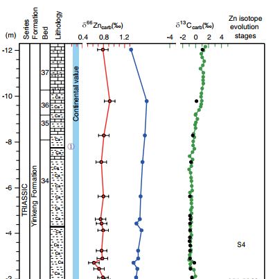
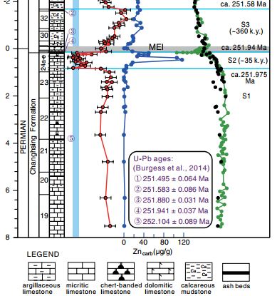
The K-Pg event (RIP non-avian dinosaurs, plesiosaurs, ammonites), is famously associated with a layer rich in Iridium, an element rare on the earth’s surface but much more common in material in space. Similar connections are found between other extinctions and Zinc. The P-Tr event (RIP trilobites, nearly everything else) shows a spike of Zinc in marine sediments immediately before the extinction. A recent study (Liu et. al 2017) also shows how the isotopes of Zinc change over time. Zinc is an important nutrient for marine phytoplanktons, meaning their growth changes the isotopic ratio of Zinc in marine sediments. Using this they demonstrate not only that more Zinc is found, but that it came from volcanic or igneous material entering the ocean. This happened abruptly around 35 thousand years before the extinction event. Soon after, the ratio shifts back in a way consistent with phytoplankton activity returning to normal within 360 thousand years.

Liu figure 2a


Figure 2b from Liu et al. Showing Figure 2b from Liu et al. Showing changes in Zinc concentrations and isotopic ratios immediately before the Carbon isotope changes associated with the extinction event.

Other studies show anomalous peaks of Nickel abundance just before the P-Tr event in many sections across the world. Once again the source is inferred to be volcanic activity. Different sets of forensic evidence point to an obvious suspect – the Siberian Traps – an enormous area of volcanic rocks covering a huge area of Russia that was formed across the P-Tr boundary.

The Murder weapon

Volcanic eruptions are dangerous to be near. It’s obvious why life suddenly swamped by lava will not survive, but a mass extinction is a global phenomena. How can a volcanic area kill animals or plants on the other side of the world?

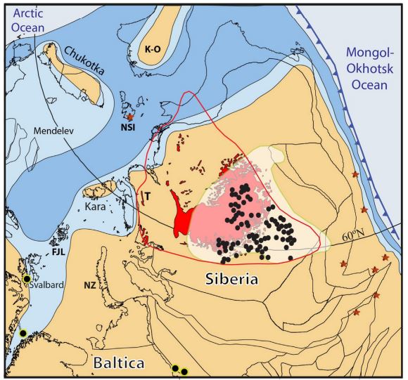
Jerram figure 1

Figure 1 from Jerram et al.

Figure 1 from Jerram et al. showing extent of Siberian Traps, highlighting sill intrusions, coal and explosion pipes.

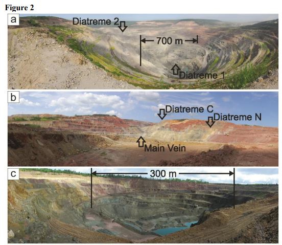
One clue comes from odd structures found around the Siberian Traps, for example within the Tunguska Basin1. These structures are pipes called diatremes, formed by gaseous explosions.

Some diatremes are formed by gas ready mixed within the magma, but with these Siberian pipes the gas came from heating of the sedimentary rocks that were already there. Buried below the many lava flows, are flat sheets of rock called sills that pushed between existing sedimentary layers. These sills heat up the surrounding rocks, which in the Tunguska basin include much coal and evaporite rocks. This heating produced vast volumes of CO2 and CH4 that poured out of the pipes into the atmosphere.

Figure 2 from Polozov et al. Showing portions of basaltic pipes, exposed within mining works.

Figure 2 from Polozov et al. Showing portions of basaltic pipes, exposed within mining works.

These gases of course affect the climate. A huge outpouring of CO2 and methane, plus also nasty gases such as SO2 represent a pretty convincing murder weapon. A brand new paper demonstrates malformed parts of terrestrial plants about this time, attributed to pollution. Sudden ocean acidification and climate change followed by a collapse in planktonic growth leading to the the death of the dependent food webs is a uncontroversial story. It may be a story we are beginning to retell as gas forms mysterious holes in the ground in Siberia once more.

Killed and killed and will kill again

The Siberian Traps are just one of many Large Igneous Provinces (LIPs). Other ones are also associated with extinctions. The pleasingly named CAMP province, found in Atlantic facing areas of Africa, Europe and the Americas, overlaps in time with end-Triassic mass extinction event (RIP conodonts and various reptiles & amphibians).  An open-access paper from mid 2017 demonstrates a link between sills intruding into organic-rich sediments and the extinction event – exactly as proposed for the P-Tr event.

Figure 1 from Davies et al

Figure 1 from Davies et al

The bodies are piling up. The Late Ordovician extinction event (RIP 85% marine species, no big groups) has been linked to Mercury enrichment in marine sediments. The authors link this to a LIP, even though one of this age has not yet been found.

What do we know about this serial killer? LIPs are thought to be formed by huge plumes of rock, rising from the edges of odd features on the very floor of the mantle. Their ability to kill may depend on the nature of the crust they rise into. Both the P-Tr and Tr-J events see sills intruded into sediments. The Deccan Traps, active across the extinction of the dinosaurs (K-Pg) rose through basement rocks, so there were no sediments to heat, meaning they pumped out only volcanic gases. Maybe this is why the extinction event required an impact to finish the job.

Case for the prosecution

“So, ladies and gentlemen of the jury, I suggest to you that the accused is a serial killer. The mighty plesiosaur, the ever-busy scuttling trilobite, even the wriggly conodont, all were killed by the monster sitting before you. It killed, not by showy eruptions and square miles of lava, but by the silent injection of sheets of magma deep underground. This devilish act then poured huge quantities of poison into the air, bringing the very earth to its knees.”

We’re not quite ready for a trial. Some of the evidence is circumstantial and we certainly don’t have a full roster of victims. But LIPs should be high on the list of anyone’s list of suspects for the greatest murders the world has ever seen.