Plate tectonics is the core unifying concept that has underpinned our understanding of the solid earth for over 50 years. To describe your research as moving “beyond plate tectonics” is quite a claim, but Trond Torsvik and the group he leads have some remarkable science to back it up. By tracking the movement of the earth’s plates over half a billion years they trace the effects of hot plumes of rock rising from the edges of structures sitting just above the earth’s core. Their research seeks to explain the origin of diamonds, immense volcanic eruptions linked to mass extinction events, the break-up of continents and how shifts in the earth’s axis caused glaciation in Greenland.
Dance of the plates
Trond Torsvik is a Norwegian scientist with a background in palaeomagnetism – studying fossils of the earth’s past magnetic field frozen in rocks – to trace the past locations of continents. Palaeomagnetism can tell you the latitude at which an ancient rock formed1. Torsvik worked with those in other disciplines – palaeontology and geology – to trace the slow joining and splitting of ancient continents.
This research (which involved many other scientists) has given us a pretty good view of how the earth’s plates moved around over the last 500 million years. But these movements are only the surface expression of the flow of the underlying rocks, the earth’s mantle. Now, as director of the Centre for Earth Evolution and Dynamics at the University of Oslo (CEED) Torsvik seeks to produce an integrated understanding of deep mantle flow – mantle dynamics – and how it drives plate tectonics and other surface processes.
Undoing subduction
The earth’s mantle convects. Although made of solid rock, over geological time-scales it flows like a liquid and we understand the physics of this process well enough to produce computer models of it. One important factor is subduction – as oceanic crust cools it sinks back into the mantle, changing the patterns of flow.
Based on our understanding of how the continents moved in the past, the CEED group (Bernhard Steinberger in particular) have calculated where ancient subduction zones were and therefore where the subducted plates ended up in the deep earth. These models of ancient mantle flow and subduction link our surface observations with deep-earth processes.
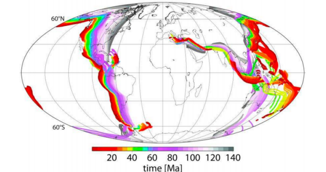
The diagrams below show how subduction zones have moved over time. The outline of the continents is fixed, representing a stable reference frame. The coloured lines show how subduction zones at the edges of plates have moved over time2.
The red lines correspond to modern subduction zones, but the colour coding shows how where they used to be in the past. Note how the western edge of the North America plate has moved east over time3. Also note how it shows the subduction zone that used to exist north of the Indian plate and which ceased around 60 million years ago as India and Asia collided (as the oceanic plate in between was completely subducted).
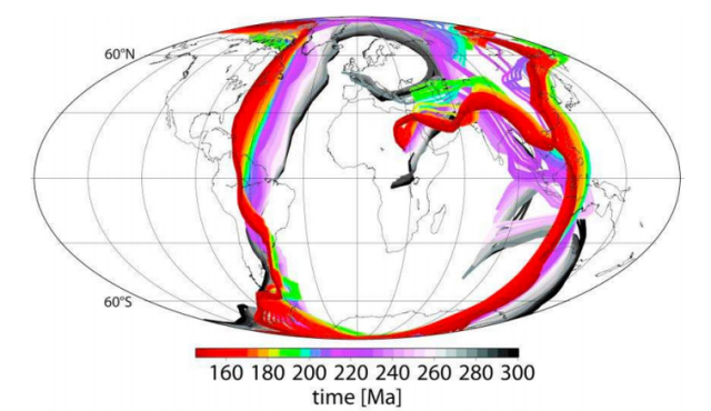
Here we have the same picture, but starting from 140 million years ago and moving back to 300 million years ago, the beginning of the Permian. These are the subduction zones that surrounded the ancient continent of Pangea.
The diagrams aren’t showing it directly, but they remind us that the oceanic crust that passed through these subduction zones is still down there in mantle; imagine the series of coloured lines as sheet descending down into the earth – that is a rough image of what is down there.
Deep structures affect the surface
Mantle plumes have long been suggested as the cause of chains of volcanic islands (like Hawaii). Many believe the concept has been overused and that some proposed plumes don’t exist – this is a controversial area. Torsvik and CEED have taken the debate forward by presenting a testable hypothesis – that big plumes form around the edge of structures at the base of the mantle and that this has been happening for hundreds of millions of years.
Seismic tomography shows mysterious lumps at the very base of the mantle. They are called Large Low Shear Velocity Provinces (LLSVPs) and one sits under Africa and another under the Pacific. They are probably patches of different composition, but no-one knows for sure.
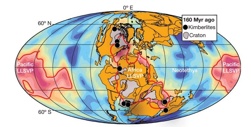
The CEED group believe these LLSVPs haven’t moved for a long time, so they took their models of plate movements to show how surface features have moved over them over time. They also plotted the locations of unusual volcanic features called kimberlites and vast piles of lava called Large Igneous Provinces (LIPs). The diagram below shows an example from 160 million years ago – here they’ve plotted the ancient location of the continents, plus that of the LLSVPs (in red). Note that kimberlites are found where areas of craton (thick old continental plate shown as grey areas) are above the edges of an LLSVP. Kimberlites are the host rocks for diamonds, so this result is not of purely academic interest.
This pattern holds when the analysis is done for other periods in the past, also when looking at modern active hotspots. Put all the data together and the pattern is quite impressive. Note that kimberlites and hotspots are not shown in their current position4 but the continents are.

This is a startling result. The fit isn’t perfect (the white dots don’t fit the pattern) but nothing on this messy planet of ours ever is.
So why are LIPs and kimberlites associated with the edges of the LLSVPs? The linking factor is deep plumes, which interact with deep continental lithosphere to produce kimberlites (and bring diamonds to the surface). Big plumes cause LIPs and the one shown above around the location of modern-day St Petersburg is the Siberian Traps which caused the largest mass extinction ever know at the Permian-Triassic boundary.
Surface processes affect the deep earth
What links plumes and the edges of the LLSVPs? Think back to those diagrams of ancient subduction zones and those curtains of ancient oceanic crust sinking into the mantle. Modelling of mantle flow through time shows that the ancient subducted crust reaches the base of the mantle where it pushes up against the LLSVPs. The flow of heat from interior of the earth to the surface drives the hot material rising up through the mantle but the interaction between plate and LLSVPs provides plausible mechanisms to get plumes started – the sinking plate pushes on the edge of an LLSVP and creates domes that turn into plumes.
What I like about this work is that by presenting a clear mechanism and predictions of how the deep and surface earth work together it is eminently testable. If mantle plumes form at the edge of LLSVPs, how does this affect the chemistry of the molten rocks that reach the surface? Perhaps one side contains the LLSVP material and another not. Any new seismic tomography data can be compared with the computer models that underlie this research. Does this research give us a new way to find diamond deposits? Finding answers to any of these questions will either help confirm the hypothesis or take research in new and interesting directions.
Our wobbly world
So much science, so little time! But allow me to test your attention span a little more and talk about my favourite example of how research from CEED links the surface and the depths of this planet.
The presence or absence of ice on this planet is one of the longer-term climatic cycles observable in the fossil record. For all of the last half-billion years, glaciation has been restricted to the southern hemisphere – until the last few millions years. Climate is the major control over glaciation, but a paper this year points to three ways in which deep earth processes caused glaciation in Greenland to start.
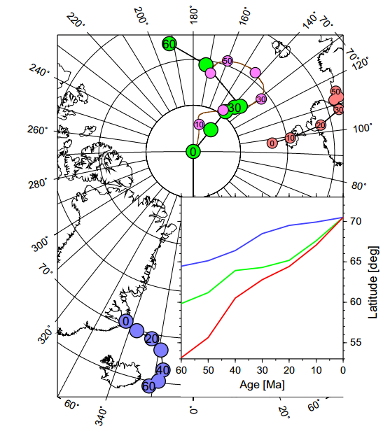
Firstly, Greenland is unusually high (and so cold) – this is because the deep plume now centred on Iceland thinned the Greenland lithosphere and, from five million years ago, fresh ‘plume pulses’ pushed it up. Secondly, standard plate-tectonics has caused it to drift north (blue points and lines in diagram) by 6 degrees. Thirdly and most mind-bogglingly, changes in the distribution of density of the earth’s interior have caused the earth’s pole of rotation to move closer to Greenland by 12 degrees (green points are observation, pink are theoretical calculations).
If you’ve ever pushed a barrel or ball part-full of water, you’ve some sense of what lies behind the third cause, known as “true-polar wander”. Classroom globes have have a solid rod down the earth’s axis, but the real earth does not – it rotates around an axis called the ‘maximum moment of inertia’ that is determined by the distribution of mass within the planet. If this distribution of mass changes over time, then the axis changes and the poles shift to compensate. Modelling suggests that the shift of the north pole towards Greenland was caused by increased subduction under East Asia and South America.
Plate tectonics explains subduction. But models that show subduction tweaking the earth’s axis to bring glaciers or tickling the deep earth to create mantle plumes that can kill off nearly all life, break up super-continents, and send diamonds tinkling up to the surface. That really is going beyond plate tectonics.
References & image credits
This post is necessarily a skim over large amounts of complicated research. If you don’t believe it’s true, at least read the papers yourself. All are available online.
Source of images are in the image text. All either from open-source papers or produced under fair-use.
This Nature paper links LLSVPs, diamonds, plumes and LIPs.
Torsvik, T., Burke, K., Steinberger, B., Webb, S., & Ashwal, L. (2010). Diamonds sampled by plumes from the core–mantle boundary Nature, 466 (7304), 352-355 DOI: 10.1038/nature09216
This details the mathematical models linking subduction, LLSVPs and the initiation of plumes.
Steinberger, B., & Torsvik, T. (2012). A geodynamic model of plumes from the margins of Large Low Shear Velocity Provinces Geochemistry, Geophysics, Geosystems, 13 (1) DOI: 10.1029/2011GC003808
This links deep-earth processes to the onset of glaciation in Greeland.
Steinberger, B., Spakman, W., Japsen, P., & Torsvik, T. (2015). The key role of global solid-Earth processes in preconditioning Greenland’s glaciation since the Pliocene Terra Nova, 27 (1), 1-8 DOI: 10.1111/ter.12133
This contains the detail about true polar wander.
Steinberger, B., & Torsvik, T. (2010). Toward an explanation for the present and past locations of the poles Geochemistry, Geophysics, Geosystems, 11 (6) DOI: 10.1029/2009GC002889
Thank you. I’ll read the references.