A very pretty map
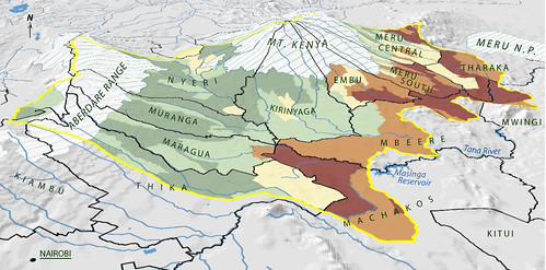
The flickr caption reads: “Map of the the Upper Tana landforms and rivers published in ‘Nature’s Benefits in Kenya Nature’s Benefits in Kenya: An Atlas of Ecosystems and Human Well-Being,’ 2007 (image credit: ILRI and the World Resources Institute, the Department of Resource Surveys and Remote Sensing of the Kenya Ministry of Environment and Natural Resources, and the Central Bureau of Statistics of the Kenya Ministry of Planning and National Development).”
I really like how the topography and rivers show up on this map, but I wish it had a clearer key of the colors and of the black-outlined areas. Are they watersheds or political subdivision? [Note the original source clears it up: They are political district boundaries]
Used under a Creative Commons license from ILRI on Flickr.