The earth’s surface is not fixed. Oceans come and go and continents are constantly moving, breaking up and reforming like blobs of oil on the surface of a stock-pot.
Since tectonic plates are not flat (they collectively form the surface of the not-flat earth), their movement over the surface of the earth is best described as a rotation. Just as maps are distortions of the global globe-like reality, so most diagrams of plate tectonics ignore the rotational possibilities. Nonetheless, the complicated reality of plate movements over hundreds of millions of years has created some startling examples of spinning continents.
Sutherland in Scotland is a fabulous place, and has long been a geological nursery for budding geologists. Its name means ‘South-land’ in Norse, as the Viking influence was strong. Appropriately there are strong links with the geology of Sutherland and that of Scandinavia. The phase of deformation that formed the classic Moine Thrust is linked with the Scandian orogeny, the phase of mountain building that dominates the geology of Norway.
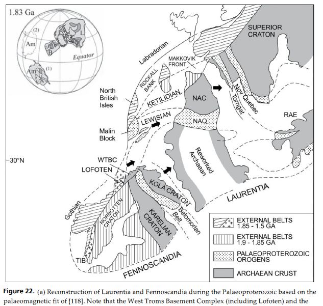
A recent open-source paper (Bergh et al. 2012) makes a more striking connection – between the ancient Lewisian Gneiss and basement rocks of similar age from near Tromsø in Arctic Norway. I went there recently and, believe me, it’s a long way from Scotland. The paper lists surveys the geological history of both areas and finds many similarities. It suggests that were part of the same orogenic belt 1.83 billion years ago, as shown in this diagram.
As is usual in such figures, the lines of modern day coasts are used to allow correlation with modern day geography. The rocks of modern-day NW Scotland correspond to the area labelled LEWISIAN, whereas the LOFOTEN and WTBC rocks are now in Arctic Norway. The outline of Scandinavia is close to its modern-day orientation, whereas Greenland and Atlantic Canada (“Laurentia”) are upside down, to our eyes.
How did we get from there to our modern-day situation?
Let’s jump forward a billion years or so.
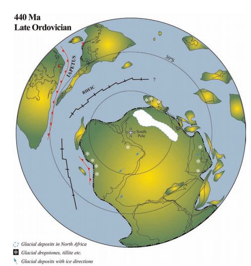
Firstly, we are now in the southern hemisphere. Secondly, Laurentia is in a more ‘normal’ configuration – the shape of Greenland is easier to pick out. The ‘Scandinavian block’ has rotated around 180° in the same way. An ocean, called Iapetus has formed between our Norwegian rocks (marked with a little red T) and our Scottish ones (an L).
By the late Ordovician, the Iapetus ocean was closing again and Baltica is returning to collide again with Laurentia, only by now it has rotated by 180°. Again.
Soon Iapetus closes, causing the Scandian orogeny which glues together the rocks of Baltica and Laurentia. Our Scottish and Arctic rocks become fixed back into a single continent. The rotation of Baltica while it wandered off means that entire length of Norway now separates two areas of crust that once were next to each other.
The Atlantic ocean has formed since then, of course, but along a line slightly different to that of Iapetus, so now the ‘Laurentian’ rocks of North west Scotland (and Ireland) are separated from similar rocks in Canada and Greenland. Will they be reunited in the future or will future continental rotations keep them apart? Only time will tell.
References
The last two diagrams are figure 2 and figure 7 from Cocks and Torsvik (2006)
Steffen G. Bergh, Fernando Corfu, Per Inge Myhre, Kåre Kullerud, Paul E.B. Armitage, Klaas B. Zwaan, Erling K. Ravna, Robert E. Holdsworth, & Anupam Chattopadhya (2012). Was the Precambrian Basement of Western Troms and Lofoten-Vesterålen in Northern Norway Linked to the Lewisian of Scotland? A Comparison of Crustal Components, Tectonic Evolution and Amalgamation History Tectonics – Recent Advances, Prof. Evgenii Sharkov (Ed.), ISBN: 978-953-51-0675-3 DOI: 10.5772/48257
Cocks, L., & Torsvik, T. (2006). European geography in a global context from the Vendian to the end of the Palaeozoic Geological Society, London, Memoirs, 32 (1), 83-95 DOI: 10.1144/GSL.MEM.2006.032.01.05


Pingback: Scandinavian crust now in Alaska! | Metageologist