Old tectonic scars run deep: the magnitude 5.0 earthquake in Ontario

A post by Chris RowanYesterday, eastern Canada was shaken by a magnitude 5 earthquake. This is, at first glance, a rather surprising event, because if you were to ask me to point out the most likely place for an earthquake to occur in Canada, I would point west, to the plate boundary marked by the Cascadia subduction zone (which eventually links up to with the San Andreas Fault farther south). In contrast, Ontario and Quebec are several thousand miles from the nearest plate boundary. However, perhaps I shouldn’t be so surprised: the rupture is located smack in the middle of a zone of enhanced risk in the seismic hazard map for this area. A look in the USGS’s historical database reveals why: there have been a number of earthquakes of similar or greater size in this region in the last century: a magnitude 4.9 in 2005; a 5.9 in 1998; a 5.8 in 1944; a 6.1 in 1935; and a 6.2 in 1925. There are also reports of a what is possibly up to a magnitude 7 earthquake way back in 1663. Although earthquakes within plates might not quite follow the tectonic rules seen at plate boundaries, it seems in this case, at least for the moment, past seismic activity does provide some indication of where to expect future large(ish) earthquakes.

Hazard.png
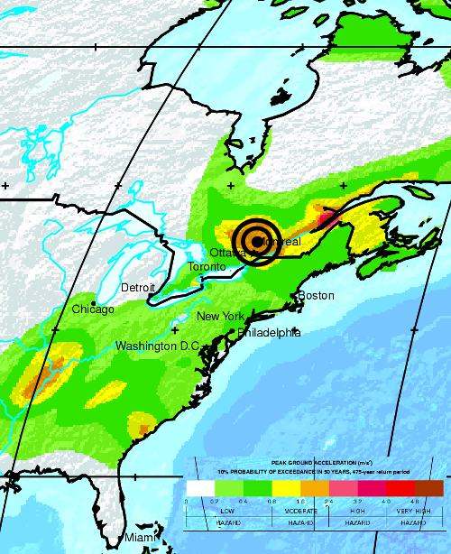
Seismic hazard map for Eastern Canada. Source: Global Seismic Hazard Assessment Program.

So why is this particular region so much more earthquake-prone than the rest of eastern Canada? Earthquakes within plates occur where they are not quite strong enough to support the forces driving motion, causing them to deform slightly. These weak points are generally found in older, fault-riddled bits of the crust that have gone through the plate tectonic wringer one or more times in the geologic past. Although there is currently no active plate boundary on the East Coast of North America, in the last 1000 million years or so it has been through a continental collision (the Grenville orogeny associated with the formation of the supercontinent of Rodinia), a rifting event (the formation of the Iapetus Ocean), then another continental collision (the closure of Iapetus and the formation of the supercontient Pangaea), then another rifting event (the opening of the present Atlantic). Faults related to all of these past episodes of tectonic activity can be found along the margin, as summarised in the color-coded figure below, taken from Thomas (2006) (pdf); this concentration of structures, easily reactivated by any applied tectonic stress, are the reason that this edge of the North American plate is much more seismically active than the continental interior.

inheritance_s.png
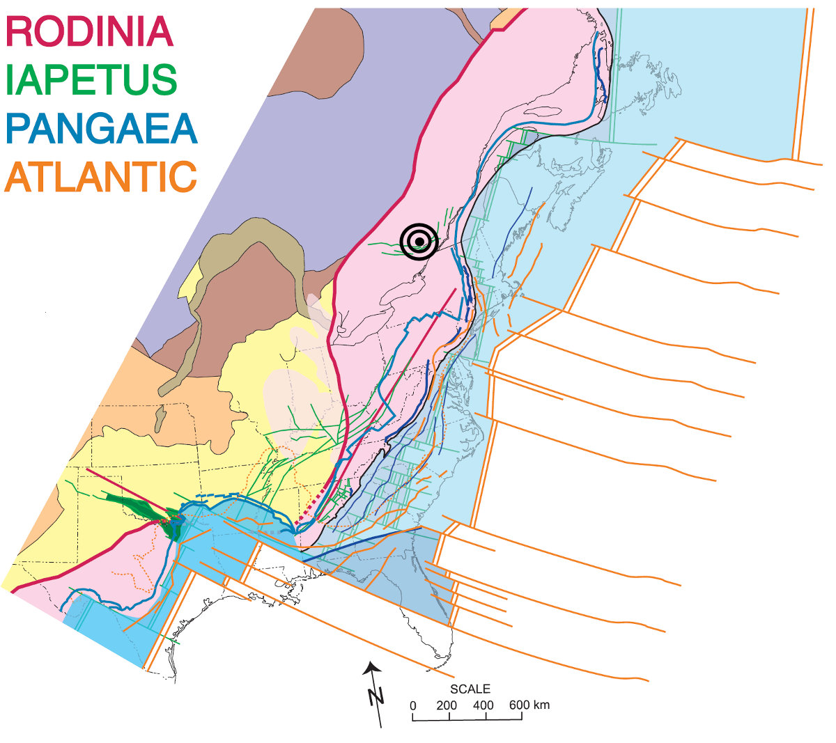
Click image to enlarge. Source: >Thomas (2006).

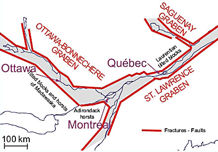
This particular earthquake appears to be associated with a small extensional graben formed during the opening of Iapetus (green lines), although a little inboard of the main locus of rifting; it is thus a failed rift, similar to the one associated with the New Madrid earthquakes. Here’s a close-up, courtesy of fellow geotweeter CPPGeophysics

OttawaGrabens.jpg

It’s interesting to see how tectonic processes that operated, and ceased, hundreds of millions of years ago, can still have a profound impact on the patterns of earthquakes today.

Categories: deep time, earthquakes, geohazards, geology, structures, tectonics

Where on Earth was Chris?

A post by Chris RowanMy regular readers are probably quite used to my occasional bouts of silence on this blog, but my low internet profile in the past fortnight has been for the quite justifiable reason that I was away on holiday. I had a blast, and unsurprisingly I quite blatantly indulged my inner geo-nerd when selecting my destination, which means several cool blog posts are in the pipeline. As a teaser, I give you the following two photos, and invite you to guess their geographical and geological provenance.
P6080019.JPG
P6080290.JPG
No prize in on offer save kudos for your geo-sleuthing skills, which will hopefully discourage those of you who communicate with me via other channels, and therefore already know where I’ve been hiding, from cheating. Guess away!

Categories: outcrops, photos

The intimate coupling of hydrologic and geomorphic evolution of basalt landscapes

A post by Anne JeffersonResearchBlogging.org
How does a landscape go from looking like this…

<2000 year old landscape on basaltic lava with no surface drainage
~1500 year old basaltic lava landscape with no surface drainage

to looking like this?

2 Million year old landscape on basaltic lava
2 Million year old landscape on basaltic lava. Note steep slopes and incised valleys

Find out in my new paper in Earth Surface Processes and Landforms.
Hint: Using a chronosequence of watersheds in the Oregon Cascades, we argue that the rates and processes of landscape evolution are driven by whether the water sinks into the lava flows and moves slowly toward springs with steady hydrographs or whether the water moves quickly through the shallow subsurface and creates streams with flashy hydrographs. Further, we suggest that this water routing is controlled by an elusive landscape-scale permeability which decreases over time as processes like chemical weathering create soil and clog up pores in the rock. And as a bonus, because of the high initial permeability of basaltic landscapes, the formation of stream networks and the dissection of the landscape appears to take far longer than in places with less permeable lithologies.
Jefferson, A., Grant, G., Lewis, S., & Lancaster, S. (2010). Coevolution of hydrology and topography on a basalt landscape in the Oregon Cascade Range, USA Earth Surface Processes and Landforms, 35 (7), 803-816 DOI: 10.1002/esp.1976

Categories: by Anne, geomorphology, hydrology, paper reviews, volcanoes

Urban streams with green walls

ResearchBlogging.orgWill Dalen Rice and a friendNote: This post is a collaborative effort by Anne and guest blogger Will Dalen Rice, a graduate student in the Department of Geography and Earth Sciences at UNC Charlotte. He had the misfortune of taking a couple of courses from Anne this semester and has become a certified stream junkie, going out on rainy nights to see how high Charlotte’s urban streams are running.
Most cities were started around the idea of available surface water resources. Development and misuse of our streams (ex: “dilution is the solution to pollution”) has resulted in the modern urban stream. These streams are straight and good at carrying storm water, full of sediment and pollutants, and they lack good habitat for plants and animals. Now that we are beginning to notice how degraded and trashed these city waterways are though, scientists and engineers are beginning to attempt to address the form and function of these waterways to hopefully return them to a more “natural” (or at least aesthetically pleasing) state. While there are many stream restoration techniques, they often involve mechanical manipulation of the stream channel and banks and the planting of riparian plants along the stream corridor. As the streamside ecosystem redevelops, the idea is that health of the stream will also improve (leave it to nature to clean up our messes, given the chance).
For large urban streams, the standard practices in stream and habitat restoration are sometimes not possible, often because decades of infrastructure development have pinned the stream into a narrow corridor. So other approaches need to be considered, and Robert Francis and Simon Hoggart of King’s College London discuss ways that existing artificial structures can be put to work to mitigate some of the ecological impacts of urbanization. In the specific case of the River Thames in England, habitat development has been observed on man-made structures, and furthermore, certain types of man-made structures grow life better than others. Francis and Hoggart show that indeed plants (and therefore animals) can develop in a riparian zone better when brick and wood and rougher materials are used over concrete and steel. If concrete and steel already exist, adding brick and wood can further trap sediment for habitat growth (like gluing a cup of dirt to a steel wall). They suggest that this should become standard practice when thinking of restoration efforts in large, urban waterways.
The NOAA’s Northwest Fisheries Science Center says Thornton Creek in downtown Seattle exemplifies “the challenges facing rehabilitating urban streams.” But a look at the NOAA picture below shows that this stream is also emblematic of a riparian ecosystem that has developed within the constraints of the existing structures and maybe even a spontaneous model for the sort of restoration that Francis and Hoggart envision.
Seattle urban stream from NOAA website
Francis, R., & Hoggart, S. (2008). Waste Not, Want Not: The Need to Utilize Existing Artificial Structures for Habitat Improvement Along Urban Rivers Restoration Ecology, 16 (3), 373-381 DOI: 10.1111/j.1526-100X.2008.00434.x

Categories: by Anne, environment, hydrology, paper reviews

Accretionary Wedge #25: An Illustrated Glossary of Cool Geological Things

A post by Chris RowanA post by Anne JeffersonWelcome to the latest edition of the Accretionary Wedge geoblogging carnival. We’ve been delighted by the response to our call for your favourite geological imagery, and the number of nominations we’ve received has been matched by their diversity – images have ranged from the microscopic to continental scales, from the depths of geological time to the present day, from the igneous to the sedimentary. The only way we could think of to do this smorgasboard of earth science justice was in the form of a visual dictionary, matching the images you’ve provided to the feature or process that they exemplify. Clicking on each image will allow you to see it in all its full-resolution glory at the original post, which in many cases also provides some more background on the geological feature or process depicted. Fun, pretty and at least a little bit educational – we hope you’ll have as much fun looking through our little glossary as we had putting it together.

A

Arch, natural – Formed by differential erosion at the base of a narrow ridge.

Photo: Arch, Arches National Park from Geotripper

Geotripper.jpg

B

Beach – deposit of unconsolidated sediment (sand, gravel, or shell fragments) at the land-water interface. One of many coastal zone morphologies.

Photo: Unknown beach with channel deposits. From Michael Welland.

Sandglass.jpg

GeoSciBlog breccia.jpg
Breccia – coarse sedimentary or volcanic rock with angular clasts

Photo: Pyroclastic breccia, Eagle Mtns, west Texas. From geosciblog.

Butte – prominent, isolated hill with steep sides and flat top. Smaller than a mesa.

Photo: Monument Valley by Dino Jim.

Dino Jim Mon Valley.jpg

C

Canyon (or gorge) – a deep, steep-sided valley, often formed by a river incising into a plateau or mountain range.

Photo: Canyonlands National Park from Geology Happens

Geology Happens.jpg

ebb tidal delta.jpg
Coastal zone – region where interaction of terrestrial and marine processes occurs. Morphology can take the form of a beach, barrier island, delta, cliff, or wave-cut platform.

Photo: Ebb-tidal delta – eastern Brazil. From Geologia Marinha e Costeira.

Conglomerate – coarse sedimentary rock with rounded clasts.

Photo: Ogallala/Arikaree formation near the Pawnee Buttes in north eastern Colorado (conglomerate butte landscape) from Russ Dale

Dale Cong.jpg

D

Debris flow – type of mass wasting where large clasts are carried in a mud-water mixture.

Photo: Debris flows, Pacific NW. From Anne Jefferson

Debris flow.jpg

PoolsRiffles.jpg
Dessication cracks – fractures formed by the shrinkage of clay, silt, or mud as it dries out from subaerial exposure.

Photo: Riviere de Terre – natural ‘artwork’ featuring dried, cracked clay. From Pools and Riffles.

Diagenesis – post-depositional alteration of sediments at low temperatures and pressures, often leading to the growth of new minerals in response to changing geochemical conditions.

Photo: pendant calcite crystals precipitated within meteoric aquifers during late Ordovician sea-level fall, Appalachians. From Suvrat.

Suvrat.jpg

Taconic.jpg
Differential weathering – divergence in the degree of weathering and erosion of different lithologies exposed to the same environment. Differential weathering is a factor in the formation of arches, buttes, and mesas, as well as steep slopes where some layers form vertical cliffs and other rock layers have subvertical exposures.

Picture: Letchworth State Park in Castille, NY, painted by Levi Wells. From John van Hoesen.

Continue reading

Categories: geology, photos