Sedimentary basins have been described as ‘tape recorders’1 that preserve evidence of past events. Some sedimentary basins contain ‘recordings’ of grand tectonic events – plate collisions and mountain building. The information is stored as subtle but compelling patterns in the type of sand grains. Combined with studies of linked metamorphic and igneous rocks, they allow us to form a very rich understanding of past – to ‘listen in’ to dramatic stories from earth history.
Sandstones are made of sand, that has become stuck together to make rock2. These sand grains come from the breakdown of rocks that no longer exist. Whole mountain ranges are brought low by slow everyday processes. The mountains may be gone, but the stuff they were made of remains, as humble sand.
Most sand grains are overwhelmingly made up of quartz, followed by feldspar and fragments of rock. Other types of grain are there, but they make up a tiny proportion of the rock. To study these less common grains, geologists bash the sandstone back into sand and pour that into a heavy liquid. The common grains float to the top and many of the rarer ones sink. Geologists can then separate out the ‘heavy minerals’ and identify them under a microscope.
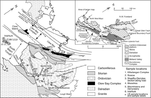
A dramatic example of the usefulness of heavy minerals comes from Ireland’s South Mayo trough. This area of Ordovician volcanic and sedimentary rocks sits within a complex collage of rocks shuffled around by the Caledonian orogeny. It is broadly a syncline in shape, with two sets of outcrops – a northern and a southern limb.
Today, the South Mayo Trough sits within the Eurasian plate, but it was born in the middle of an ocean that no longer exists.
All at sea
The oldest sediments are found in the Letterbrock formation3. The sediment matches what you would expect from erosion of the rocks found immediately north of the basin, the Killadangan formation which has been interpreted as an accretionary prism.
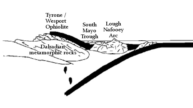
In the south, the sediments correlate with the Lough Nafooey group of volcanic rocks. These formed as part of an oceanic island arc within the Iapetus ocean. Together, this evidence suggests the South Mayo Trough formed as a forearc basin.
The oldest sediments in the north also includes ‘ophiolite detritus’ – grains such as epidote and chromite that are typical of the erosion of oceanic crust. In the overlying Derrymore and Sheefry the ophiolitic debris becomes dominant – serpentine and chromite are so abundant that some beds are unusually heavy and have a ‘soapy’ feel. The volume of chromite increases up through the Sheefry and its chemistry becomes richer in Cr/Ni/Mg.
Grains of mica and zircon in these rocks have been dated. They show a variety of ages, all Precambrian, consistent with being derived from the old rocks of the Laurentian margin.
During this time, the volcanic rocks of the south show a change in composition. The earliest rocks are basaltic. Patterns of rare earth elements and other geochemical signatures are consistent with an oceanic island-arc origin (only oceanic crust involved). Over time the rocks become progressively more acidic, moving into andesitic and ultimately rhyolitic compositions. Rare earth elements show that the tectonic environment changes. Initially the oceanic island arc magmas were formed from melting of oceanic crust only. Progressively, more and more melt is derived from melting of Laurentian continental crust.
Collision but no mountains
The volcanic rocks therefore record that subduction zone has run out of oceanic crust – the island arc has collided into the continent – the leading edge of which was subducted and melted to feed the volcanic arc.
At the same time as these events recorded in the South Mayo trough, sediments formed on the edge of the Laurentian continent the Dalradian Supergroup) were being buried, heated and deformed in Grampian/Taconic orogeny. The sediments were buried underneath the oceanic crust (ophiolite) and oceanic island arc as they collided with the continent.
This implies the South Mayo trough itself was part of the upper plate, thrust onto the continent. The work orogeny is synonymous with mountain building, but here we have a sedimentary basin sitting on top of an orogeny, not only being preserved, but continuing to fill up with sediment. Various explanations have been given: the subducting slab and the ophiolitic upper nappe may have been unusually dense. The sedimentary basin, packed with serpentine and chromite certainly was. The sea-level at this time (mid-Ordovician) was unusually high, between 250-500m higher than at present. It’s possible the South Mayo trough was only plastered onto the side of the orogen, not thrusted completely over the top.
Whatever the reasons we should certainly be grateful that the sedimentary tape recorder was preserved. It was still rolling and about to record some more remarkable events.
A change of direction
Plate tectonics is a global phenomena. The closure of the subduction zone and the arc collision did not stop the overall convergence between the Laurentian continent and the Iapetan oceanic crust. In time another subduction zone formed, this time putting oceanic crust underneath the continent – a change of direction.
While this flip of subduction was taking place, conditions in the South Mayo trough at first didn’t change. The Lower Derrylea formation contains ophiolite debris from north (chrome spinel and purple zircons) and arc debris (clear zircons) from the south.
![Diagram showing links events in the South Mayo Trough and other areas. Supporting Appendix. Key to columns: A, Western Newfoundland Ordovician Shelf; B, Notre Dame Bay arc stratigraphy; C, West Newfoundland ophiolites; D, Notre Dame arc ages; E, Quebec.New England; F, Scottish Highlands; G, Achill; H, Connemara; I, Clew Bay Complex; J, Scottish ophiolites; K, north limb of SMT; L, south limb of SMT (thicknesses in K and L in meters), detrital mica ages [71] in SMT; M, Derryveeny; N, Mweelrea; O, Derrylea; P, Rosroe; Q, Maumtrasna; R, Sheefry; S, Southern Uplands accretionary prism; T, detrital mica ages [70] in Southern Uplands accretionary prism.](http://all-geo.org/metageologist/wp-content/uploads/2013/08/Dewey-figure-2.jpg)
Diagram showing links events in the South Mayo Trough and other areas. See Dewey (2005) for detailed explanation
Dating of these minerals shows that they were hot only 5-10 million years before they ended up as sand grains. Such rapid unroofing of metamorphic rocks suggests something more potent that erosion is at work. The Dalradian rocks in this area show rapid cooling at this time also suggesting something was bringing them rapidly towards the surface. What tectonic mechanisms could explain this?
With the creation of a new subduction zone to the south, the force of the converging plates was no longer supporting the thickened rocks of Taconic/Grampian orogeny. Now in a back-arc position, they extended rapidly. Major faults rapidly brought deep rocks to the surface sending metamorphic minerals cascading into the South Mayo Trough.
Once the Dalradian debris starts flowing, there are no more dramatic changes in the recording. It ends fairly soon after – the whole area is covered by unconformable Silurian sediments – but there is one more thing.
By 464Ma, the whole area is now in an ‘Andean’ type of tectonic environment, with intermediate vulcanism associated with the new subduction zone. This is recorded as ignimbrite layers in the South Mayo Trough, but also as granite intrusions within the nearby Connemara terrane. Once more we are able to make links between the surface and deep processes.
This is what makes these techniques and these rocks, so special. Linking surface to deep processes, resolving timescales to within a million years – these are very powerful ways of understanding how the earth really works.
References
Dewey J.F. (2005). Inaugural Article: Orogeny can be very short, Proceedings of the National Academy of Sciences, 102 (43) 15286-15293. DOI: 10.1073/pnas.0505516102
Mange M., Idleman B., Yin Q.Z., Hidaka H. & Dewey J. (2010). Detrital heavy minerals, white mica and zircon geochronology in the Ordovician South Mayo Trough, western Ireland: signatures of the Laurentian basement and the Grampian orogeny, Journal of the Geological Society, 167 (6) 1147-1160. DOI: 10.1144/0016-76492009-091
Brown D., Ryan P.D., Ryan P.D. & Dewey J.F. (2011). Arc-continent collision in the Ordovician of western Ireland: stratigraphic, structural, and metamorphic evolution, Arc-Continent Collision, 373-401. DOI: 10.1007/978-3-540-88558-0_13


Pingback: The Great Ordovician meteor shower | Metageologist