I clearly remember the most important moment of my geological career. I was resting my back on a glacially-polished wall of gabbro, my feet in an Irish bog, talking to myself in the sunshine. As a young man with bushy hair and beard, tattered field gear, wellington boots and a battered rucksack held together by darning and staples, I was recognisably a geologist, a ‘hammer-man’ in local parlance.
I was looking around as I talked to myself. This is a natural enough thing to do in beautiful Connemara. I’ve spent a lot of time admiring the interplay of sun and cloud and rain and glacial peaks there. I can especially recommend gazing out to sea, enjoying the sense of being at the end of the world, with the whole Atlantic before you. On a practical note, the west is where the showers come from; a glance that way gives you your own personal very-short-range weather forecast.
This time I was looking right at the low bobbles of the Dawros peninsula and left to the rounded hump of Currywongaun and Doughruagh’s majestic black stack. My gaze wasn’t aesthetic but geological, conceptual. In my mind these were no longer hills, but bodies of molten rock, injected into the beating heart of a mountain range millions of years ago.
I was talking because I was telling myself a story. A scientific story, where every detail is backed with evidence and armoured against the necessary pedantry of the scientific process. My story was a good one – good enough to turn into a scientific paper – I had not wasted the last 2 years of my life on pointless data collection after all. Best of all, my story felt like The Truth. I could dare to let myself believe that I understood events that happened miles underground millions of years ago. It was a good feeling.
The Dalradian in 1995
The modern consensus about the rocks of Connemara is that they are Dalradian sediments, deformed and metamorphosed over a short period of time by the Acadian/Grampian orogeny. Back in 1995 when I was a scruffy PhD student1 this was far from being a consensus. Some scholars (including, not incidentally, one of my supervisors John Dewey) were promoting the short orogeny model, but others disagreed. They had evidence on their side, too.
Understanding the timing events in deformed metamorphic rocks is helped by correlating phases of deformation and metamorphism. For Dalradian rocks there was a consensus that the ‘D2’ phase involved burial, heating and intense folding. D2 is associated with the original Barrovian style of metamorphism. Later, D3 involves less intense folding and in some areas Buchan style metamorphism linked to heating following the intrusion of gabbro intrusions into already hot rocks.
In the 80s and 90s, radiometric dating began to be applied to these problems. Direct dating of metamorphism was not then possible and the most reliable source of ages were zircons crystallised in igneous intrusions. Intrusions like the Ben Vuirich granite in Scotland – in 1989, Rogers et al. dated this as 590 million years old. Previous studies had interpreted the granite as being older than D2, but younger than D3. Scottish gabbros linked to D3 had been dated to around 490 million years, meaning that D2 and D3, far from being part of a single quick orogeny must represent, not a single quick orogeny, but entirely different mountain building events separated by 100 million years. In 1994, remapping of the Ben Vuirich granite showed that it was in fact pre-D2 (Tanner and Leslie, 1994), allowing advocates of the quick-Taconic model to argue it was pre-orogenic and therefore not relevant to these debates.
This was going on slightly before and during my PhD research. The challenge of linking igneous intrusions to deformation sequences was core to my work.

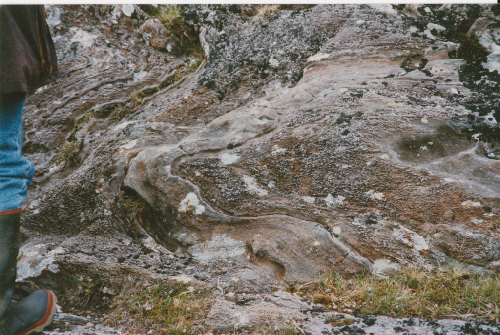
D3 folds of a D2 fabric. Sillimanite blebs aligned axial to the D3 folds. Connemara. Wellington boots for scale courtesy of the Geological Survey of Ireland
The Geology of Connemara in 1995
The rocks of Connemara correlate with Scottish events. There are extensive gabbro and calc-alkaline intrusions associated with an intense D3 phase of metamorphism. Most of these intrusions are in the south and the pattern of metamorphism reflects this, with sillimanite grade metamorphism close to them and lower temperatures further north.
These gabbros were originally correlated with D2 deformation, but in 1990 Geoff Tanner, partly in response to the Ben Vuirich date, argued that they were post-D2 and pre-D3.
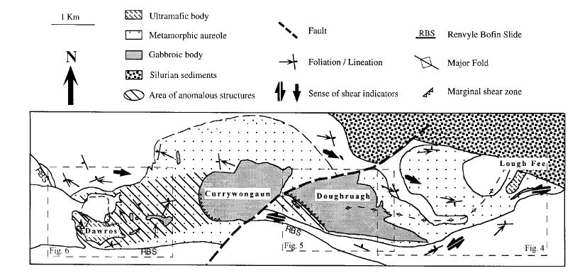
For my PhD, I focused on a set of gabbro intrusions in the north of Connemara known as the Dawros-Currywonguan-Doughruagh2-Complex (DCDC). I produced detailed maps of the structures in these deformed rocks, focussing particularly on fabrics and shear-sense. I also did a lot of metamorphic petrology, describing the large metamorphic aureole around the intrusions. After a few years of this, I had enough data to start putting my story together.
The Currywongaun contains xenoliths of partially melted granulite facies sedimentary rock. Within these xenoliths are fragments of folded rocks, suggesting that had been deformed before the gabbro was intruded. The gabbro was intruded into rocks that were already at amphibolite grade (550 °C). There is abundant evidence that the magma was affected by deformation during its intrusion – it is syntectonic. Small intrusions within the DCDC are deformed by a fabric that is the same as the D2 fabric in the sedimentary rocks surrounding it. Overall, this evidence points to a syn-D2 page for the intrusion of the gabbros.

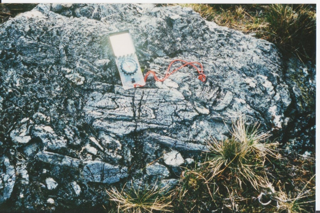
Folded fabric in a block of quartzite within a gabbro intrusion. The whole area is a xenolith, fractured by partial melting
There’s more. The larger gabbro bodies are extensively hydrated. Gabbro intrusions start off relatively dry, but if they are intruded into already hot metamorphic rocks they drive even more metamorphic reactions that produce water. As the gabbro cools a little (down from an initial 1200 °C) the water surrounding it makes its way into the intrusion. This water metamorphoses the gabbro into wet amphibolite, which is weaker than the gabbro and so is preferentially deformed. The west edge of Currywonguan is the site of a fantastic shear-zone that was active at high temperatures. In the country rocks, these fabrics cross-cut granulite facies D2 fabrics and can be correlated with D3 folding.
So the gabbros were intruded during D2, but affected by D3 folding while still hotter than the surrounding rocks. A spot of primitive (but effective) thermal modelling allowed me to show that the pulse of heat associated with these relatively small intrusions would have vanished within half a million years. So D2 and D3 were close in time – consistent with the ‘quick-Taconic’ model.
Academic hurly-burly
Every good story needs a bit of conflict. For my story, it came from the radiometric dates. A 1988 paper dated the Connemara gabbros at 490Ma. Whereas 1993 and 1996 papers gave dates of around 470Ma for the D3 metamorphism. This gap of 20 million years doesn’t fit my story.
At this point, you may well be thinking that I must be wrong. Hard science, numerical analysis of isotopes must surely trump my hand-wavy field-based studies? No. Remember the paper was from 1988. Back then people still thought digital watches were a pretty neat idea. They dated zircons, not with high-precision laser beams but by chucking a bunch of them into acid. They didn’t even abrade them first. The date was based on the assumption that there was no inherited lead in them. I had no doubt that the date was wrong and I said so in public, at conferences and eventually in an academic paper.
Not everyone agreed. At a conference, after a talk I was told by a angry geochronologist that I couldn’t expect to be taken seriously if I went around saying radiometric dates were wrong. He hadn’t produced the date I disagreed with, but he clearly took it personally. This incident, the venom with which he disagreed with me, marked the start of the end of my geological career.
Closure
Some scientific disagreements remain unresolved for years. Not this one.
Anke Friedrich, a German PhD student at MIT started working on Connemara a few years after me. Soon after I’d been told off for doubting a published radiometric age, she proved it was wrong by redating the same rocks. The whole suite of dates she produced was powerful evidence for the ‘quick-Taconic’ model. All of the magmatism in Connemara and therefore the associated metamorphism and deformation lasted only 12 million years.
I was pleased to be proved right, of course, but I don’t actually remember when I first heard about it. I was so certain that I had to be correct that my reaction would have been quite mild. In this, I wasn’t unusual – I am far from the only scientist to have been hugely certain that they are correct. What strikes me now is how far away this is from the way science is ‘supposed’ to work. How can this be?
Leaning against my syn-tectonic gabbro, feeling I knew The Truth felt great. It helped motivate me: I’m only human. When I was ‘doing science’, writing papers, this feeling was irrelevant to the process of presenting evidence and suggesting hypotheses. Further, Anke Friedrich’s paper is rightly much more highly cited than mine. Her range of radiometric dates is the best scientific evidence for the ‘quick-Taconic’ model within Ireland. ‘Science’ is bigger than what goes on in scientists’ heads – its a process, not just a bunch of people’s opinions.
References
ROGERS, G., DEMPSTER, T., BLUCK, B., & TANNER, P. (1989). A high precision U-Pb age for the Ben Vuirich granite: implications for the evolution of the Scottish Dalradian Supergroup Journal of the Geological Society, 146 (5), 789-798 DOI: 10.1144/gsjgs.146.5.0789
TANNER, P., & LESLIE, A. (1994). A pre-D2 age for the 590 Ma Ben Vuirich Granite in the Dalradian of Scotland Journal of the Geological Society, 151 (2), 209-212 DOI: 10.1144/gsjgs.151.2.0209
WELLINGS, S. (1998). Timing of deformation associated with the syn-tectonic Dawros Currywongaun Doughruagh Complex, NW Connemara, western Ireland Journal of the Geological Society, 155 (1), 25-37 DOI: 10.1144/gsjgs.155.1.0025
Friedrich, A., Bowring, S., Martin, M., & Hodges, K. (1999). Short-lived continental magmatic arc at Connemara, western Irish Caledonides: Implications for the age of the Grampian orogeny Geology, 27 (1) DOI: 10.1130/0091-7613(1999)0272.3.CO;2


Thank you for such an enlightening post. I only recently came across your blog and I’ve been very pleased I did.
I don’t have any impressive geology qualifications (just undergraduate) and I think I’m more likely to take nice easy numbers above more difficult conceptual models. This would be the case if you were telling me at the time about how you felt the zircon dates were misleading. Additionally, my knowledge of structural geology is a big hole and finding other answers that don’t test my knowledge too hard can be trap.
I’ve worked a lot in contaminated land and the reports that are written always need a QA/QC section which is always larger than the original outcomes of the report. This allows those with the know to question whether the chemical analysis is reliable or whether some of the techniques may be suspect (of course this is always part of a good post-graduate thesis too). As far as applying this to geological concepts I think the biggest thing you’ve made me think about is a demonstration of how important it is to know the whole background and take all the evidence into consideration.
I also note the entrenched nature of some theories in peoples minds. Where I live in New South Wales, Australia one aspect of the volcanic history of the area has been adopted by the general public. In paticular, the remnant topography of a shield type volcano implied to people studying it in the 1960’s and 1970’s that it was huge. This really came about by drawing a line along the highest points around the edge and finding the highest point in the middle. This resulted in a model of shield volcano more than 2000m high with smooth flanks. By doing this it mean that even thick (500m) sequences of rhyolite neatly mantled the volcano implying that they flowed from a central point for distances of more than 50km (rhyolite lava is just not that liquid!).
But I am beginning to digress.
Thanks for your thoughtful… and thought provoking blog post.
Rod.