Ever since the plate tectonic paradigm-shift of the 1960s, geologists have strived to understand ancient rocks in terms of the movements of plates. The geology of north-western Ireland can be explained by what happened when a subduction zone ran out of oceanic crust back in the Ordovician. Let me take you back to before that happened.
Imagine you are floating in the sea. In 480 million years time the crust below will be in Ireland. The sea is warm – CO2 levels are high and you are fewer than 30° south of the equator. Apart from cheeky trilobites nibbling your toes, it is an idyllic place to be. You are near a large land-mass. It’s barren looking – plants are just about to learn how to survive outside the sea 1 so there is little to soften the landscape. The tumbler of gin and tonic2 you clumsily dropped has sunk into sediment that will one day be part of the Dalradian Supergroup.
Your mood has soured. Not only has your drink gone, but you’re getting creeped out by the cloud on the horizon out to sea. It’s not a fluffy, friendly one but a dark spreading plume of volcanic ash. Far out to sea, there is a line of volcanoes and they spell D-O-O-M for the peaceful spot you’ve found. Every year the volcanic arc gets a little bit nearer. Eventually it will smash into the continent behind you, grinding over the top. The peaceful sand and mud washing around below your feet will be sediment no more. The collision between the volcanic arc and the continent will transform the Dalradian sediments into the contorted metamorphic rocks that today make up much of NW Ireland.
An accident waiting to happen
Here’s a diagram showing a section through the land below. Black is oceanic crust, yellow stippled is sediment3.
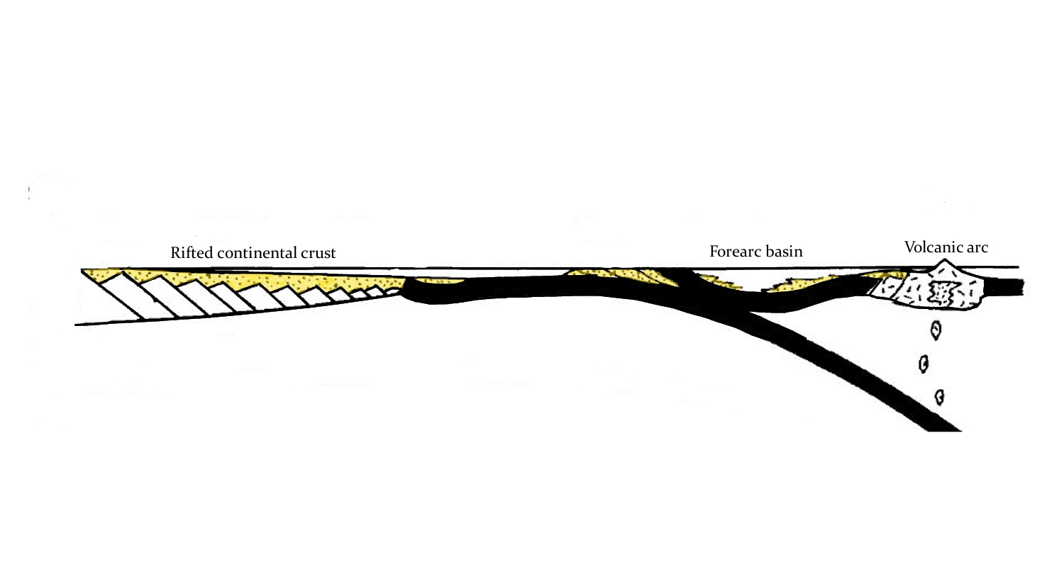
Let’s start from the left. Notice that the edge of the continent is thin and tapering – it was stretched out when the ocean basin formed. The oceanic crust attached to the continent is being stuffed down back into the deep earth. As it sinks, it is squashed and heated, starting a complex process that ends with molten rock reaching the surface. Over time this magma has formed a volcanic arc, a small piece of thickened crust.
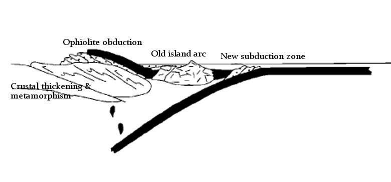
This situation can’t last for ever. Once all of the oceanic crust of the lower plate has run out, normal subduction comes to an end. The upper plate slides over the thinned continental margin and ends up lying on top of the continent – a process called obduction. The island arc and forearc basin are squashed against the continent. Like a bulldozer hitting a pile of sand, the arc collision compresses and thickens the crust. The Dalradian sediments become thoroughly deformed and heated and are now a wildly complex set of schists and marbles. This process creates a mountain belt, an event known as the Grampian orogeny.
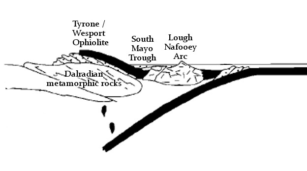
As shown in the diagram below 4, the orogeny does not stop plate convergence. The old subduction zone has been destroyed, but another one is created in the opposite direction. This process, called ‘subduction flip’ changed the tectonic stress regime; it’s believed to have led to a process of ‘orogenic collapse’ whereby the thickened crust extends and thins, bringing metamorphism to an end. The overall tectonic event was remarkably quick, around 15 million years.
Where are they now?
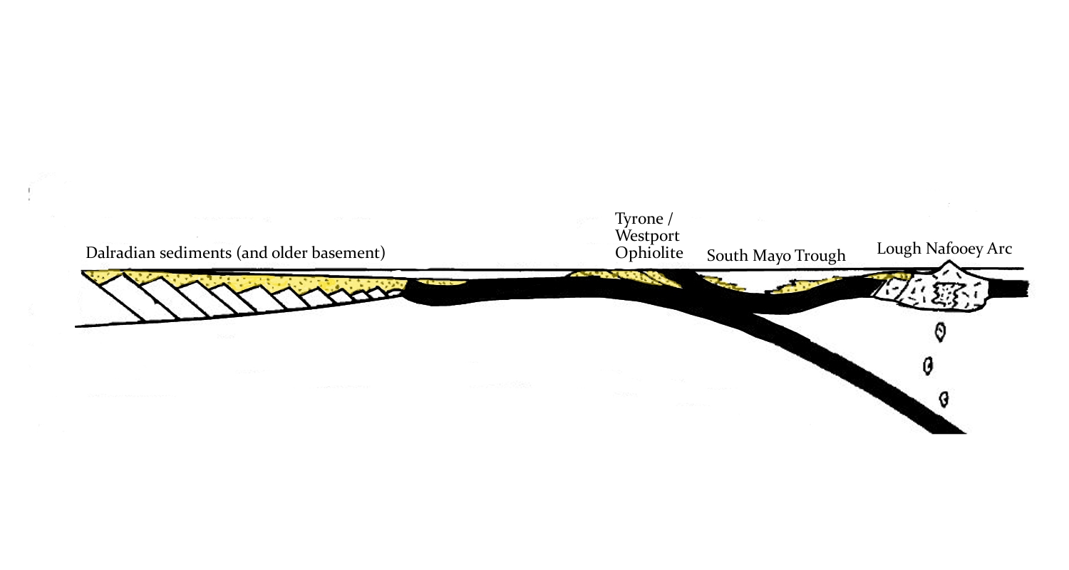
This type of orogeny can be recognised as it leaves distinctive rock types behind. Ophiolites, pieces of oceanic crust within continents are found in several places in Ireland; the largest example is the Tyrone ophiolite, but traces of oceanic crust can also be found in Mayo, near Westport, in the Clew Bay and Deerpark Complexes. The story goes that there are no snakes in Ireland because Saint Patrick, while fasting on top of Croagh Patrick, threw them down into Clew Bay. That the sea-facing side of the mountain contains a lot of green serpentinite suggests the origins of the story have a geological angle5.
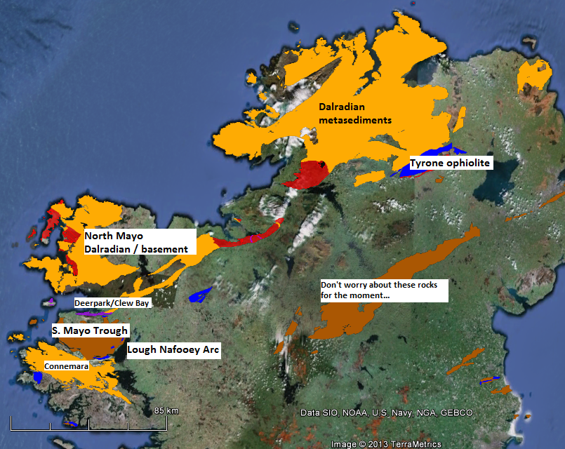
Parts of the volcanic arc can now be found around Lough Nafooey, just to the south of the South Mayo trough, which corresponds to the fore-arc basin. The Dalradian sediments and underlying older crust make up most of the land to the north west of these rocks.
Let’s revisit the cross-sections, labelling the modern day equivalents. Before the collision:
and immediately afterwards:
A wider context
Ireland was only a small section of a continental margin that stretched from rocks now in Greenland down into the eastern US and Canada. The Grampian orogeny also affected Scotland and the same arc-collision event is found in eastern Northern America where it is known as the Taconic orogeny.

Recognising the connection across the Atlantic helped geologists understand the causes of these complicated patterns in the rocks – different sections show different parts of the orogeny and synthesising research across a wider area leads to a richer understanding. The patterns are complex – more so than I’ve shown above. There were probably multiple ‘accretion events’ where different arcs collided at different times. The pattern of plates in modern day SE Asia is seen as an analogy here – they may have been multiple subduction zones and arcs within the wider ocean.
Geological is 4-dimensional, and the Grampian/Taconic orogeny reminds us of this. The timing of the various accretion events varies because the edge of the continent was not straight. Promontories (sticky-out bits) were hit by the arc sooner than parts where there was more oceanic crust to be consumed. Another complication is that continents don’t break cleanly: fragments of continental crust can end up far from the main continent (for example Rockall in the Atlantic). The arc whose collision caused the Grampian orogeny in Scotland (now found buried in the Midland Valley) is thought to sit on continental crust.
These 15 million years were a very important time for the crust of the northern half of Ireland, but are only a small part of the wider geological history of Ireland. I’ll leave the story unfinished here and tell you what happened when the new subduction zone ran out of oceanic crust in future posts.
References
RYAN, P., & DEWEY, J. (1991). A geological and tectonic cross-section of the Caledonides of western Ireland Journal of the Geological Society, 148 (1), 173-180 DOI: 10.1144/gsjgs.148.1.0173
Hollis, S., Roberts, S., Cooper, M., Earls, G., Herrington, R., Condon, D., Cooper, M., Archibald, S., & Piercey, S. (2012). Episodic arc-ophiolite emplacement and the growth of continental margins: Late accretion in the Northern Irish sector of the Grampian-Taconic orogeny Geological Society of America Bulletin, 124 (11-12), 1702-1723 DOI: 10.1130/B30619.1
Bird, A., Thirlwall, M., Strachan, R., & Manning, C. (2013). Lu-Hf and Sm-Nd dating of metamorphic garnet: evidence for multiple accretion events during the Caledonian orogeny in Scotland Journal of the Geological Society, 170 (2), 301-317 DOI: 10.1144/jgs2012-083
Hugely interesting. Thank you for your efforts, very appreciated.
a proper okay see of The Grampian / Taconic orogeny in Ireland & Pleasurable like it