This post is part of my journey into the geology of mountains.
Plate tectonics is one of the most successful scientific concepts of the Twentieth Century. It revolutionised the study of the Earth and is one of the few cases where the term paradigm shift can correctly be used.
The theory describes the earth in terms of a small number of rigid plates, whose motion can be described as a rotation on the surface of the earth. Plate boundaries, such as subduction zones or mid-ocean ridges are where these plates move relative to each other. For oceanic plates this description is well-nigh perfect; the zone of deformation at the plate boundary is narrow.
Continents are different. On the broad scale, no difference. The relative motion of Siberia with the lowlands of India can be described accurately by the relative movement of the two tectonic plates, with a rate of convergence of c. 60 mm/yr. Anywhere in between though, things are more complicated. There are major thrusts at the base of the Himalaya, that look like a classic plate boundary, but these only account for about a third of the convergence. The rest of the movement is distributed throughout the Himalayas and the Tibetan Plateau behind it. This can be confirmed by direct GPS measurements. California is another example of this. The strike-slip movement of the Pacific plate relative to North America is distributed across most of California, as confirmed by direct measurement.
So, if a plate boundary can cover 1000s of kilometres and classic plate tectonics does not describe what is going on in these diffuse plate boundaries, then it is not such a useful concept when studying mountain belts. This realisation led to the creation of the term continental tectonics in the 1980s.
Continental tectonics is a general term covering concepts that attempt to describe the behaviour of broad deforming areas of continental crust. So how to get a handle on this behaviour? One approach is to think about areas where the zone of deformation between plates is very wide. The best example is Tibet.
The Himalayas are not important – What’s the most remarkable geographic feature of the Tibet/Nepal area? You probably thought of Mount Everest (to use the western name) or the larger set of 14 peaks that are over 8000m in height across the Himalayan mountain belt. I disagree. The Himalayas are the more glamorous, but actually the Tibetan plateau is the more remarkable feature.
Here’s a cross section of the Himalayas, generated from Google Earth, looking east:
Impressive, most definitely, but here it is again in context.
Same general direction, but note the horizontal scale is 10x longer. The maximum height is lower, but more realistic. The first cross-section I deliberately aimed for the Everest region, trying to get a large height, for the second I just crossed the Himalaya at no particular point.
Not so impressive now. The big mountains are in the Himalayas, but on average they are just the front edge of the Tibetan Plateau. The geology of the Himalayas could be viewed as a narrow plate boundary (lots of thrusting, sequence from Indian through to Asian rocks). What is hard to explain is why the Tibetan Plateau exists at all. Even more mysterious is the fact that recent faults in Tibet are extensional! To see extensional faults, where things are pulling apart, in a large area within a major compressional zone is rather counter-intuitive.
Many Earth Scientists have tried to understand Tibet, some have turned to mathematics, some to plasticine.
The extrusion model – One approach is to say that the concept of rigid plates still applies, it just gets more complicated. So, perhaps the area between Siberia and the Indian plains is made up of a jostling series of microplates, a finite number of rigid portions of crust. Clearly on one level, this is true. The only explanations I’ve seen of the geography north of Tibet (moving north, the Tarim Basin and then the Tien Shan mountain range) rely on the crust underlying Tibet having different properties to that underlying the Tarim Basin. Simply put, Tibet is soft and gets deformed into mountains, whereas the Tarim Basin crust is strong and stays rigid. Recent evidence of subduction of Tarim Basin crust underneath Tibet supports this.
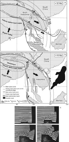
One microplate model of Tibetan Geology is inspired by physical analogue models of the India-Asia collision. Analogue models work by taking a scaled model of the crust, with similar physical properties to the crust (again scaled). The model is then deformed. This particular model the Asian plate as soft material (plasticine) and India as a rigid indentor. Critically, the eastern side of the model was left open, on the basis that the oceanic crust there does not provide any ‘resistance’. As the Indian rigid indentor was pushed into Asia (simulating the original plate collision) crust was extruded east in big flakes separated by large breaks in the material. This extrusion model is most associated with the renowned Paul Tapponier.
Look at the diagram below (source details at end of article):
The final panel shows photos from a plasticine analogue model as described above. The first two panels are a sequence, showing how material is extruded out from Tibet into South-east Asia. This extrusion process is also consistent with extension in Tibet. The crust is being compressed on a North-South axis but is simultaneously extending East-West.
An implication of this model is that these major faults are in effect mini-plate boundaries. For the model to work these faults need to cut the entire crust and to show major (1000 km) displacement. Therefore, one way of better understanding Tibet is to do a detailed investigation of a fault in Vietnam.
Searle et al. 2006 and Searle et al. 2010 tease out the detail of deformation and metamorphism around the Red River fault. This fault (near the label DNCV in the diagram above) is near metamorphic rocks and granites. Proponents of the extrusion model propose that these rocks were formed by syn-deformational shear heating along the fault, which is therefore a major crustal structure. Searle and friends refute this by detailed structural work and by deriving a Triassic age for metamorphism (which is before India hit Asia). They interpret this fault as a structure that cross-cuts older and unrelated rocks that are not caused by shear-heating.
In fact Searle and others have, for over 10 years, been arguing against the extrusion model, using various lines of evidence to show these large faults are not micro-plate boundaries.
Continuum dynamics – So, if the extrusion model doesn’t fit the evidence, how do we explain Tibet?
Another approach is to model the behaviour of Tibet using continuum dynamics. Put crudely, this takes the micro-plate idea to its logical conclusion. If you divide a rigid plate into smaller and smaller sections ad infinitum, what do you get? If every atom is free to move independently of the rest, you get something that behaves like a fluid.
Stop! Before you click away in disgust at my madness, consider the mantle. This convects, just like a fluid, does it not? Given enough time (and high enough temperatures) rock will act like a fluid, just a very very viscous one. Rocks on the surface of Tibet are cold and brittle, they are cut by faults, but most of the volume of the crust is deeply buried and quite hot. Continuum dynamics is an approach that models the entire crust and regards brittle structures on the surface as more symptom than cause.
Continuum dynamical approaches to continental deformation identify two drivers: external ‘boundary forces’ (rigid India colliding) and internal ‘body forces’ caused by gradients in crustal thickness. If these balance out then an equilibrium is achieved, if they don’t, then crust will flow. In the face of continued Indian convergence (associated with a force pushing India north) the crust thickens and the Tibetan plateau is created.
Continuum dynamics is most closely associated (at least in my mind) with the work of Phil England of Oxford, but the key papers involve many other big names in Geology.
Summary and next steps – So, in summary, continents don’t behave like oceanic plates. Portions of them behave like rigid micro-plates, but in areas like Tibet the crust can behave like a fluid. By modelling modern day topography and crustal surface flow (which can be directly measured via GPS), the viscosity of Tibetan crust has been estimated to be only 10-100 times more than convecting upper mantle. Our mental picture of a fluid planetary interior and a rigid crust above is too simple: sometimes even the crust behaves like a fluid.
This post is the second step of a journey to explain my pictures of Mount Everest. What lies ahead? I feel I ought to have a go at doing more justice to rheology and crustal structure as I’ve barely struck it a glancing blow here. These concepts will help us approach different and perhaps better models of Himalayan geology. Also I’m bound to get distracted along the way by some pleasing diversion or other. Stick with me as the journey will be worth it. Why?- “because it’s there“.
Declaration of Interest. Mike Searle and Phil England taught me, plus many proponents of the extrusion model are French. I’ve tried to be even-handed, I have, but do be aware of the tribal loyalties and ancient anti-gallic prejudices that are bubbling around in my subconscious.
Further reading & references
This post owes a lot to Searle et al. 2011 (doi: 10.1144/0016-76492010-139) which helped refresh my memory and bring my knowledge up to date. I shall be returning to it in future posts as I’ve only covered a small portion of it.
Pete Molnar’s Nature paper from 1988, Continental tectonics in the aftermath of plate tectonics is an early introduction of the distinction between continental tectonics and class plate tectonics.
Searle et al. 2006 (doi:10.1144/0016-76492005-144) and Searle et al. 2010 (doi: 10.1130/GES00580.1) are specific studies arguing against the extrusion model by looking at the Red River fault., The discussion arising from the 2006 paper gives a view from proponents of the extrusion model (doi:10.1144/0016-76492007-065).
Image credits
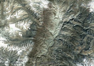
Images taken from Google Earth. Diagram taken from Searle et al. (2011) with implicit permission of the Geological Society of London and kind permission of Prof. Mike Searle.


a very interesting post. best compliments for your clear explaination of the india/asia collisional tectonics. I ask you if the mechanism you describe here can describe also tbe situation aeound the Bajkal graben. I hope that in the next future you will write with the same simplicity something about the conrinental plate limits between american and asian plates in NE China and eastern Siberia.